TR Replies
Sick, Dylan! I can see the ripping Park Glacier video but not your pictures. The bike shuttle sucked. 😅
Good to recognize those times when we get away with it, stoked for your descent of the gnar
Did you get eyes on the Park Headwall 'schrund?
Love the persistence. Congrats on getting one of the big fish, and doing it on your own terms!
Great work on the stitched together image. I'll be mentally skiing it all summer.
I'm planning to be out there this Sunday - I'll keep my eyes peeled and reply back if I find them! It'll be my first time up there - what's the hike in from the trailhead like? Worthy of hiking boots or ok with ski boots? Thx
Great report Kenji and stunning photos as usual. Way to get out there and thanks for sharing
Hi TimD, it was nice chatting with your friend Harry. Glad you enjoyed the day trip... I think in some ways it's easier to do a big push with light packs!
Certainly conditions were not nearly as good as last week, unfortunately. Recent rain & snow up high and lack of consolidation had some real mushy conditions. Luckily the highest elevations still had some decent supportive snow. It was fun to ski off of both Sherman and the Roman wall.
Inspired by Kamtron's report my friend Harry, my son Teal, and I did this route July 5. We were skeptical that a single push from sleeping in the parking lot was something mere mortals could do in a reasonable time. We left at 6am and were back 11.5 hours later. Harry stopped around 9000' and my son and I continued on to summit in good conditions. Which resulted in Harry meeting Kamtron coming down from Sherman Peak about where we had left him behind. Most...
Myself, I found great skiing above 6k ft, exept on steeper sun exposed slopes.
I skied Snowgrass flats to Johnson Pk and back. The difficulties on the trail getting to Goat Lk have probably melted out by now. When you get soft corn over frozen snow, it can all slide away.
My son and I repeated this trip July 1. We left the car at 8:37am making Camp Muir 4:45 later, or amazingly slower than the Furher Finger report. There are now substantial snow gaps on this route. We saw a pretty good avalanche on what I think is the Kautz, a calving off of a chunk of ice that piled up in a short debris fan. We saw some helicopter activity that the rangers wouldn't say much about. We saw one guy go up on a harness suspended below the helicopter and ret...
Such a cool write-up and pix, Sam, as usual : )
Congrats on the summit and ski to you and your party.
This is fantastic - thank you for sharing. So cool to see these up close.
Loo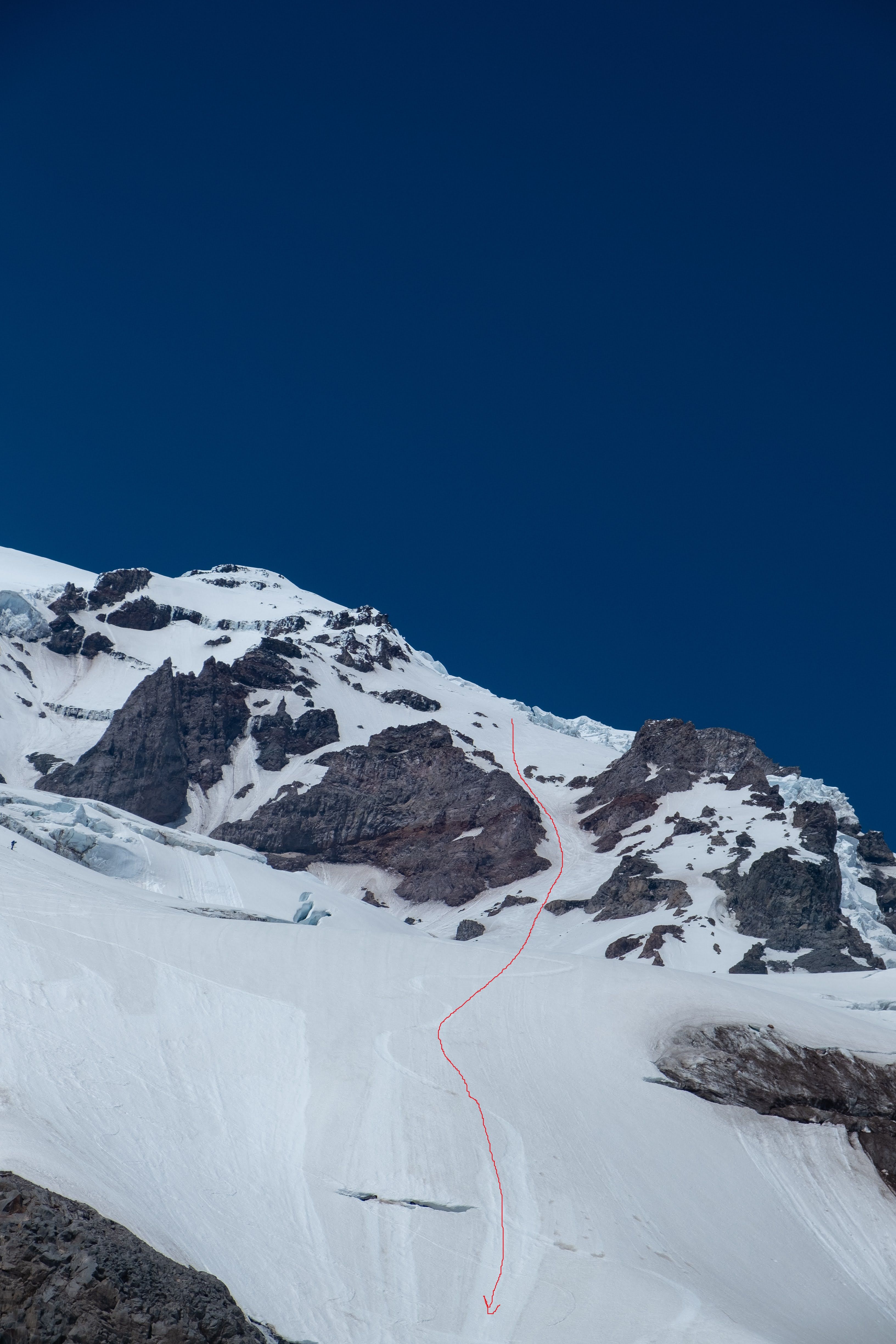
Looking back up at the line, for info on crevasses, etc.
Awesome report
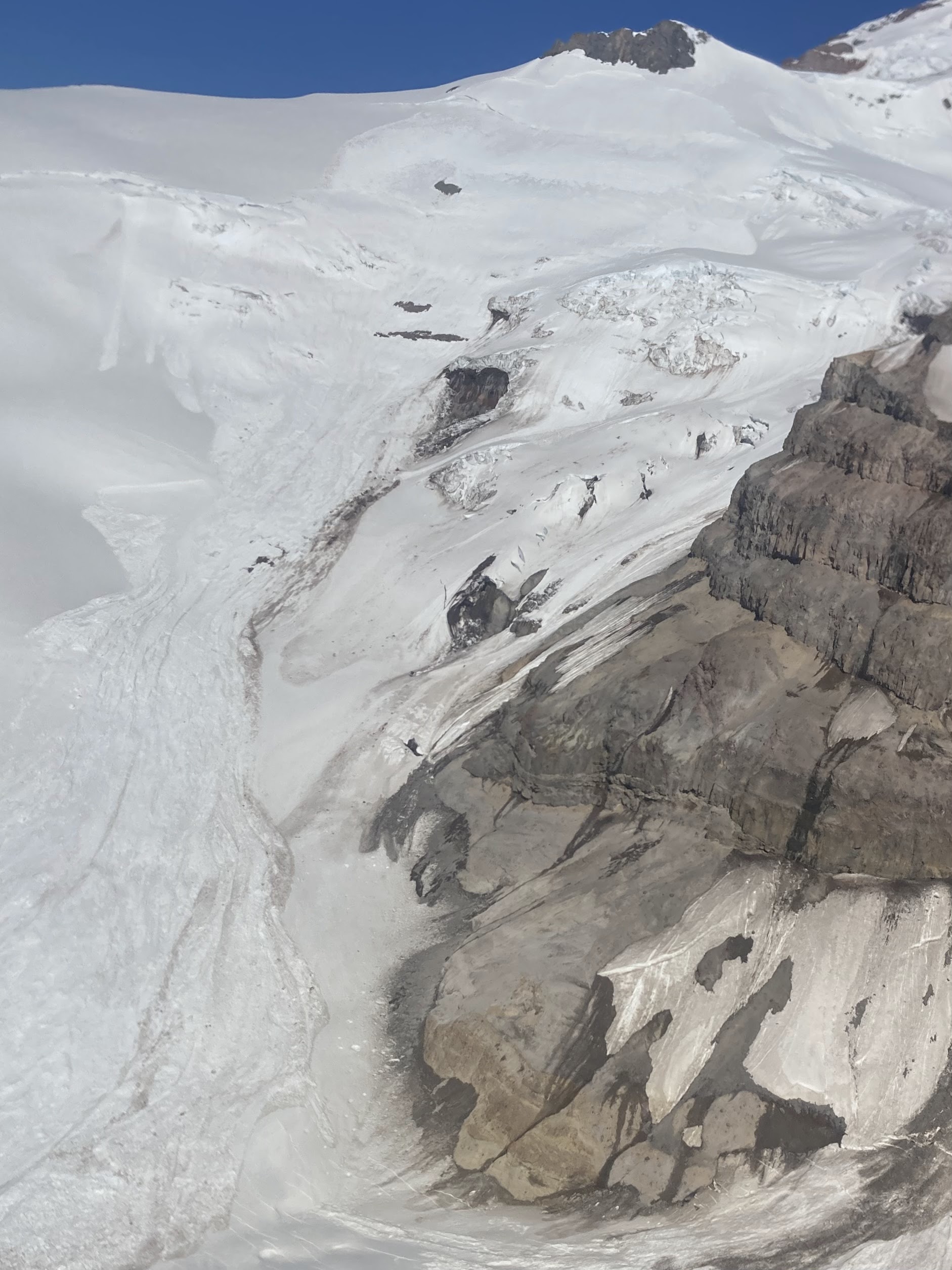
Fantastic photos. Some we have skied and others we thought about. Your photos provide the look of what it looks like from above the terrain. It was interesting to enlarge some areas.
Thank you again. 😃😊
Making (and observing) tracks is one of the fun parts about skiing, right?
Hey!! I’m the girl you helped rescue! I stumbled across this post when looking up Muir snowfield crevasses 🙈 reading this was wild, you captured the whole thing with such detail. We are forever so grateful to everyone who helped us that day, and we speak of you fondly every time we tell the story. Thank you for being there and sharing this!!
@waveshello I love it! Maybe you should write a T-themed Dr. Suess book for your daughter!
"Resort chunderfield of ice balls"... "bottomless schmoo"... Lol! This is by far my favorite type of TR--what a sufferfest. Strong work, and beautiful photos. Looks like you at least found some enviable corn conditions on Little T.
I've been...
Great trip report and photos. Your writing style is wonderful. It brings back memories.😃
@tim Nicely done! I love this tradition. Yesterday was unbelievable up there.
@kamtron I totally agree with you, but not right now. We exited Comet Falls yesterday and the trail is in rough shape. Eg the bridge over Van Trump is washed out and the water is flowing as fast as I've ever seen it. Lots of landslide damage and places to punch through snow as well.
I find exiting out the lower Nisqually is kind of f***ed up late in the day. Going down to Comet Falls is a lot less scary, recommend.
Skiing the big planar face off point Success is pretty damn fun, eh?
Nice one! Looks like a great adventure, thanks for sharing it.
Thanks Will
What's crazy is that earlier crown under Anvil is nothing compared to the more recent slab that ripped out of there some time in the last week! Climbing rangers think wet slab
Yesterday saw a poor refreeze but i also had good snow to 8k on an early lap then slightly punchy snow in Nisqually chute at 11 am
Glad people are getting it!
Decent 6/25. As mentioned windy at least down low in AM, I think this preserved snow. Excellent Corn below Anvil. Already a couple of carries above Pan Face, which is itself getting thin.
Update: It was actually pretty good today. Got real corn on the Turtle and the main slope of the Van Trump Glacier down to 8000ft, at 1pm. And below that, it wasn't so bad, slower but not sticky, aside from the most heavily cooked aspects/angles. There had been a decent refreeze overnight, even if the surfaces didn't get super hard right on top. There was also a seriously stiff breeze around 5000ft-8000ft (but calm above!), maybe that helped too.
A bit of an update on the crossing of Frying Pan Creek. The creek has changed its normal channel near the bridge. The bulk of the flow no longer goes under the bridge and instead, goes between the bridge and end of the trail. It's not really necessary to thrash through the forest and brush to go upstream to go across the log crossing in the photo in the report. Bring some crocs or let your trail runners get wet and it's possible to get to get from the trail to the bridge with a co...
In about 1978 or so I hiked the summer trail with Jeff Coburn and Rusty Dupree in July or August and skied that same lovely slope. It was the first time I ever did this sort of thing. The hikers were beyond Incredulous, as there was truly no snow in sight until right there. I submitted a photo to the Sacramento Bee and they wrote a story about it…The only one who didn’t like it was some new Ranger who thought we were going to die on a 35 degree snowfield….Good job getting the timing right - b...
Yes Zap - Sam is prolofic, a good writer and photographer, and is full of the kinds of Trip Reports everybody likes to see on this site…But you didn’t summit?😉
that is tower mountain. That is not the success couloir. Both nice lines with some spice to ski though.
A GREAT trip report with the photos plus the conditions you encountered for a BIG day.😃
Kam - we looked at it yesterday. I believe it is actually both. There is debris below it. It looks like it release on the edge of the the classic upper paradise glacier crack.
We saw a few other large crowns on steep faces below the finger skiers right of the lower Nisqually. (Kam - close to the location of the largest wet slide we've ever seen circa out 2018? finger ski)
Hopefully everything stabilizes.
@brad8379 yeah we initially missed it, but did eventually find the entrance into the alder on the west side of those slide paths. As I mentioned, we'd been relying on finding exposed, cut logs because the trail itself was still snow covered, and there is an old tread that is no longer maintained that we'd initially followed east after crossing thunder cr, but it just ends at the alder. There isn't any flagging on the thunder cr side of the maintained trail right now and all...