TR Replies
Nice work! Even after skiing that line 4 times, it still gets my heart pumping when I look down that roll looking for the exit to the lower face.
author=Oyvind_Henningsen link=topic=5066.msg21290#msg21290 date=1151991236]
a climbing party very early in the day had kicked perfect steps (thank you!!).
I strive for perfect. Glad to be off service.
Did you ski the route as climbed?
Everything turned out much smoother and easier than I ever expected 8)--would have taken heavier skis.
My many thanks to you all for a terrific trip. And yes Paul, again nice to run into you.
I'm sorry about waking you all up !!
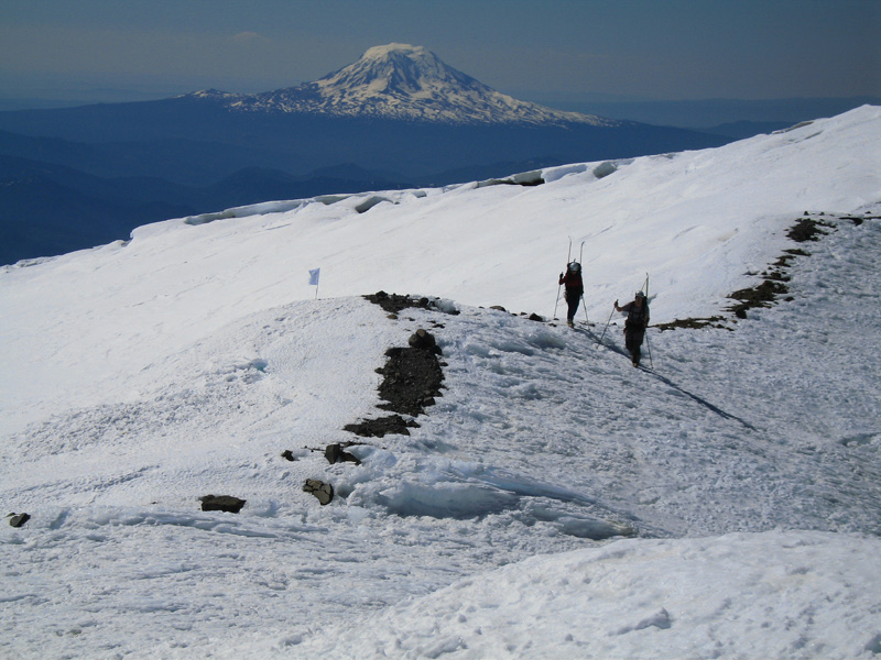
Your group sure has the photographers. Here's one of Oyvind with Adams and Helens.
I think you guys were just a bit behind us in the chutes, based on hearing rumor of your being at the summit while we lazed at the false summit.
As we did the traverse out, we saw some folks who were on a climbing traverse on a snow ramp that led back up toward the s. climb from the narrow snow exit that is past the left traverse out of the base of the chutes. I wonder how high they had to climb to find a continuous ski back down to the climb?
As we did the traverse out, we saw some folks who were on a climbing traverse on a snow ramp that led back up toward the s. climb from the narrow snow exit that is past the left traverse out of the base of the chutes. I wonder how high they had to climb to find a continuous ski back down to the climb?
I can't remember for sure, but I think it was Amar Andalkar who posted about a surprising increase in snowdepths northeast of Baker and Mt. St. Helens that he noticed in his research (right Amar?). It was also posted sometime about someone noticing markedly less snow on the northwest side of Baker. I think it is a very interesting question to explore the mesoscale precipitation variations around big, isolated relief like the volcanoes. Does not only shadowing but also con...
Yes, I was a bit surprised by how much Sunrise was melted out. However I was not surprised by the pleasent day my son had skiing for a bit with as he says "the big guys". Thanks for the tour of the runs we hit Ron,, had a great time.
CW
CW
I looked over there on Sunday, Greg. Scoped out both GR and Tamanos pretty good. GR had some skiable lines on the NNE slopes but it looked like a hell of a shwack to get into them. Pretty much the same for Tamanos; the cone is still holding snow on the N facing lines but it looks like a carry all the way in. Who knows, you might be able to shoot right up there and nail those lines... us geezers don't like to carry that far ;).
If you decide to check it out you c...
If you decide to check it out you c...
It wasn't all bad. I was annoyed to miss summit views again-- both of my visits to the summit plateau have been whited out. This time I turned back at about 14K, being too far to the north and reluctant to cross untested soft snow bridges solo (which situation was of my own making). I couldn't see slope aspects in the clouds and booted down to about 13.5K. Preparing to ski, I dropped my skin bag which promptly rolled into a crevasse >:( but then enjoyed a few good GS tur...
Nice work - sounds fun. (?)
I'm curious: how much longer do you think the Emmons will be suitable for skiing? There's a buzz about trying it in a couple of weeks if the weather and conditions allow, thus the question.
thanks,
-s
I'm curious: how much longer do you think the Emmons will be suitable for skiing? There's a buzz about trying it in a couple of weeks if the weather and conditions allow, thus the question.
thanks,
-s
Greg, I don't recall the snow coverage on Governors Ridge but it is around 6500 feet which is about the altitude of the Sunrise area. The photo gives you an idea of the type of coverage at a similar altitude.
Zap:
As you looked south, how did the Barrier Peak/Governor's Ridge basin look, in terms of snow coverage?
Nice beta; thanks...GregLange
As you looked south, how did the Barrier Peak/Governor's Ridge basin look, in terms of snow coverage?
Nice beta; thanks...GregLange
author=Zap link=topic=5066.msg21292#msg21292 date=1151996165]
Was the snow level at Cloud Cap or did you have to hike up ? Did you ski down Langille Bowl ?
Hiked up Cooper spur to 6900' and then dropped down onto remaining snow on the Elliot. Crossed over the moraine at 7500' still on snow to Cloud Cap. Coming down caught a finger more south than the main langille down to the Timberline trail. tr...
Great trip.
Jill and I are heading for Mt. Hood later this week and plan to ski Snowdome again. Was the snow level at Cloud Cap or did you have to hike up ? Did you ski down Langille Bowl ?
Thanks, Zap
Jill and I are heading for Mt. Hood later this week and plan to ski Snowdome again. Was the snow level at Cloud Cap or did you have to hike up ? Did you ski down Langille Bowl ?
Thanks, Zap
Nice trip report and photos. Your trip reminds me of my first summit on Rainier in zero visibility. That was an incredibly long day. Your trip also reminds us that not every adventure has great snow and views from the summit. It is seldom that folks talk about those trips. But most importantly it was a "roundtrip" for everyone in your group. Zap
Hello Merk- we hit patches of snow just as we entered Spray Park, where the trees end and open area begins. There are long fingers of snow to the left and right as you gain elevation, so it's hard to describe which one you give you continuous snow. That said, you should be able to find continuous snow at around 5600 feet, off to the south/hikers right of the summer trail. The hike in to Spray Park is relatively fast due to the lack of significant elevation gain, and a great trail. It t...
Looks like a fun tour you all had. How was the approach? Where did you hit continuous snow?
Nice Kam, glad you guys had a great day. No doubt, you must have heard Michael's yodel at least a few times from Rainier. :)
Nice report and good pictures. We did Tumalo a few weeks ago and it looks like the snow is holding up well (we were able to ride down to Dutchman Flats). It was pretty foul weather though, so it's nice to see what it actually looked like off the summit this year 8)
Always good to see your smilin faces. MArkhof was there too later in day. Also Julie (Olympia) fresh from summitting Everest. Four us Tom Kress , Dave Somerseth ,Alpine rose and myself summited and had a fantastic ski back down std.route. Thanks for showing Ken and Kaine the traverse out of SW chutes. The were extremely pleased. I'm working on Kaine and his girlfriend Dave's sister to sign up for GTCR class.
Our original plan was to ski two days in row but bone/muscle structures w...
Our original plan was to ski two days in row but bone/muscle structures w...
Thanks for the report Snodger. Any pictures? I'm planning on heading up there in a couple of weeks. Sounds like there will still be plenty of snow by then :D
nice work everyone! the photos are great! Michael, i thought i heard you yodel from Mt. Adams.
Nice. Plenty of P-Tex still in Kelvin's basement!
I'm totally jealous. Stupid weddings and moms! At least one of Heather's vows was to encourage Ben to ski with us more...
I agree that Vincent gets the style points for skiing that line solo. I made the traverse out of there too soon to watch you come down. As for stamina, a couple more outings and you'll probably be good to go. However, none of us will ever catch the Peacock!
The 6pm solo descent was awesome, probably to my best run lifetime. Thanks for showing me the way and for grooming out the sluff.
You guys definitely brought home how out of shape I am... Thanks for the well deserved kick in the ass.
Cent treize, c'est pas mal! C'est excellent avec le ski!
You guys definitely brought home how out of shape I am... Thanks for the well deserved kick in the ass.
Cent treize, c'est pas mal! C'est excellent avec le ski!
Mfaoro, the best way to the South Route from Seattle area is to get to Elbe like you would if you were going to Paradise (I-5, I-405, 167, 512, 161 through Puyallup South Hill to Eatonville then to the road to Elbe). At Elbe, turn south on 7 to 12, east on 12 to Randle, then south on Forest Rd 23 to Trout Lake. I just skiied the South Route this weekend (June 30-July 1) with Robie (thanks again, Robie for a great trip), and the drive to Cold Springs took 5 hours, including the side t...
author=philfort link=topic=5043.msg21232#msg21232 date=1151851433]
Up high the snowpack seems a little less than last year.
From your photos it is hard to tell, but I'd say the face has about the same, if not more snowpack on it than last year at this time. Good stuff!
Thanks for the great pictures and reports!
This was a great trip with an awesome group! I was also very happy that Corinne managed to organize a last minute baby sitter and come along. This is a route I had been wanting to do for such a long time now - great to hit it in these perfect conditions.
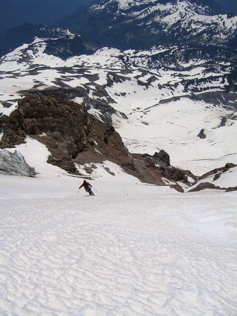
I was really impressed with the upper section of the route on the upper Nisqually, skiing was just amazing with excellent scenery.
Greg cruising the upper Nisqually:
This was a great trip with an awesome group! I was also very happy that Corinne managed to organize a last minute baby sitter and come along. This is a route I had been wanting to do for such a long time now - great to hit it in these perfect conditions.
I was really impressed with the upper section of the route on the upper Nisqually, skiing was just amazing with excellent scenery.
Greg cruising the upper Nisqually:
Thanks for the great trip report and photos guys. Really an awesome trip with great companions. Was especially glad to join you for my first ski descent from the summit (a long time goal). Congrats Greg for your first ascent of Rainier! You really hit it right with the route, weather, and conditions. Was especially nice to have such a remote feeling and direct line on this route, and to have the concerns about rock fall and too low of freezing levels turn out for the best. Oyvind and Monik...
Pin!
One of the advantages of the Mazama/Old Chute route is avoiding the shrund. A good climbing route as well as ski - no steps kicked, but in the conditions we found on the 25th it was excellent cramponing. If I was there early morning before any ice/rock fall and there was no one on the route I'd just run up the standard which is more direct, but if other parties are on it this is a very good alternative, and usually a much better ski.
One of the advantages of the Mazama/Old Chute route is avoiding the shrund. A good climbing route as well as ski - no steps kicked, but in the conditions we found on the 25th it was excellent cramponing. If I was there early morning before any ice/rock fall and there was no one on the route I'd just run up the standard which is more direct, but if other parties are on it this is a very good alternative, and usually a much better ski.
Looking at your turns and a handful more coming off of the Turtle, I don't think I've ever seen so many fresh tracks on that side of the Nisqually.
JD,
What is the date of your photos? Looks great up there. Was your alternate climbing/ski route out of the line of the schrund? Recommend it as a solid up-route?
Good Job,
Chris O'
What is the date of your photos? Looks great up there. Was your alternate climbing/ski route out of the line of the schrund? Recommend it as a solid up-route?
Good Job,
Chris O'
Howdy, Have always heard legend of this. Good Job and thanks for the incentive!
Chris O'
Chris O'
Great tour description and photos. Zap
Right on Phil, way to get after it! I had a leisurely good time at Ben's wedding in Bellingham with Sky & others.
Way to go gang! Thanks for the link to your photos and story.
Chris O'
Chris O'
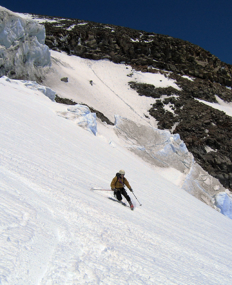
Great to have company on the route even if the 11:18 wake up call was too early, Oyvind, it was a great day of skiing. Really superior corn conditions from about 13,000 to 10,000 ft. Good thing we weren't there when that serac fall came down!
Monika and Oyvind
Paul
Monika and Oyvind
Paul
author=philfort link=topic=5043.msg21232#msg21232 date=1151851433">
Suprisingly, there was still quite a bit of snow in Phelps Creek, especially when you approach the Leroy Creek turn off.
Up high the snowpack seems a little less than last year.
Also of interest, whereas Jason Hu...
Nice adventure. Yesterday, Jill and I were returning from Camano Island with our grandsons and as we were driving south on I-5, I viewed Mt. Rainier and mentioned we would be skiing there. He pointed to Three Fingers. He must have seen you. ;)
Zap
Zap
Thanks for the beta Lowel, I've been planning to climb 3 Fingers this summer, but didn't think about taking skis - gotta get up there this week and repeat your trip!
I love seeing any skiing reports of the PNW Washington & Jefferson - having skied the New Hampshire Adams, Washington, and Jefferson, plus the PNW Adams, my goal is to ski the PNW Washington & Jefferson to complete a bicoastal Presidentials trifecta.
author=ron j link=topic=4994.msg21220#msg21220 date=1151724279]
Of course if you're after the highest score on the TP scale, do the "low left" exit. Just ski down until you run out of snow and then load up and start traversing left. this will take you across some of the most rugged drainages on this side of the mountain and make you a sure winner on the torture points scale ;D
Yes, wuhoo, that means that my brother Ben, Gape...
Thank you both! This is way helpful. I am still trying to work out the logistics with my buddies. We will see if we can work it out.
Michael 'torture point' Faoro
Michael 'torture point' Faoro
Good to see you too Telemon and glad that you enjoyed the turns. It sure is nice to get to ski from the top.
As for Michael's question about the chutes...Perhaps I'm getting lazy, but I no longer relish that traverse back to a camp above the RTM. My cohorts and I have decided that the wisest choice for a SW chutes descent is just camping at Cold Springs and going down and back in a day. When the snow continues below the chutes, there actually is quite a bit...
As for Michael's question about the chutes...Perhaps I'm getting lazy, but I no longer relish that traverse back to a camp above the RTM. My cohorts and I have decided that the wisest choice for a SW chutes descent is just camping at Cold Springs and going down and back in a day. When the snow continues below the chutes, there actually is quite a bit...
Everyone seems to have their own "right way" to do this route. And I just keep learning every time I go.
Having just done the route you seem to be contemplating if I we going to do it again this weekend I'd take the SW Chutes exit notch as high as possible skier's left (no lower than 7000) and traverse high left through a couple of tree/rock bands to a shelf overlooking a big bowl west of the Crescent Gl.
There I'd don skins again and climb up and across the...
Never mind - that was stupid - finally got home and looked at Beckeys. My memory of the route was failin' me...
It looks to me like you have to put in some serious work (and not ski down a major portion of the route) if you want to camp at 8 or 9k. The most practical thing to do is camp at Timberline and do it in a day from there.
I would still be open to hearing others experiences if you are willing to share. I am considering going with south climb scrambles who want...
Another route question - this one of the snow kind...What elevation is it best to start traversing from the SW chutes back to the climbing route? Assuming you left a tent somewhere on it...I am assuming that if you camp at lunch counter you might have to climb to get back to your tent.
What is your favorite way to do this if you are doing an overnighter?
What is your favorite way to do this if you are doing an overnighter?
Thanks for the report. Nice to hear a report from there. Was planning to do Barrett a few weeks ago but just ran out of time.