TR Replies
Heard through the grapevine that three people went for a ride in Nash Friday afternoon.
Anyone here know the details
Anyone here know the details
Too true, big lurker over here! Great day at Xtal as the kids call it. Beacons off the moment the rain came. Sweeeet!
RandoBro and Nedster over from the Kitsap Peninsula to tour at Yodelin. Long drive, 2 missed ferries, NW concrete...
TR right on, heavy, brutal conditions up and down. Took 6 of us, and 2 dogs, over three hours up from lot! Met up with SLB and boarderbro near top. Ten hearty souls!
Drop a line if headed to the Olys!
TR right on, heavy, brutal conditions up and down. Took 6 of us, and 2 dogs, over three hours up from lot! Met up with SLB and boarderbro near top. Ten hearty souls!
Drop a line if headed to the Olys!
Wendy's, not so sure. Elk burgers sound a bit wild. Veggie burger at Gustav's is the ticket.
Scott, we thought you'd be constructing your winter yurt somewhere. I sent you an email...
Scott, we thought you'd be constructing your winter yurt somewhere. I sent you an email...
Nice! The one time you ski at the pass all winter and you dont give me a call.... ;)
Elk burgers at the alpine inn.
Elk burgers at the alpine inn.
looks like fun! angus burgers eh? man those things are gross! wendy's has the good stuff.
After that much work, I had to go back again today to enjoy the team's handiwork. The skiing was just as good.
I got to tour 1 day there a few winters back... That place is seriously magical! Lucky you.
Admit it. You were just looking for an opportunity to use "discombobulations."
Kyle is working his way back, one McDonald's angus burger at a time.
Kyle is working his way back, one McDonald's angus burger at a time.
That's a groovy route. Good to hear that Kyle has overcome his discombobulations.
I guess I could only deny the touring season so long. I'm still convinced Vantage will be comfortably climbable all year too this year.
I thought you were in hibernation? Nice to see that Kyle woke your ass up.
Great photos and sounds like a great decision to keep it at the elevations you did. Can't wait to get up there. Nice report.
That place sure does draw the sledding crowd. Awesome circuitous route.
Nice tour, I have never skied that slope, but have sure looked at it, sounds like you had better conditions than across the road. Thanks for the report.
We keep thinking about going there and keep going elsewhere. It's good to hear how things are there (even if taxing!); thanks for the report.
author=kneel turner link=topic=25950.msg111312#msg111312 date=1354857460]
It.
We all know this- From NWAC: "This forecast applies to back country avalanche terrain below 7000 feet and does not apply to developed ski areas or highways."
In this case specifically, the closed area had been skied all day, and the snowpack increased 2" overnight.
But this is beside the point.
Crystal operation's reaso...
Yeah there were quite a few patience testing moments. My skinning muscles are pretty sore today but I should be feeling good the next time I get out! Thanks for the invite Luke.
author=Rusty Knees link=topic=26385.msg111345#msg111345 date=1354917521]
Looked like one of the dogs was bleeding, evidence in the skin track, and ALL of them were crapping in the skin track. Come,on, people!
Great day to be out!
My dog was the one who was bleeding a little bit but it stopped about 1/2 way up. It is only his second day touring this season. And not "ALL" of the dogs took a crap in the skin tra...
author=alpine-earth link=topic=26383.msg111374#msg111374 date=1354940929]
I was thinking about you guys when I heard about the Mission/Snoqualmie mid-week share, were you pretty psyched?
You guys skiing the lifts or doing any touring at the pass this weekend?
Didn't know about the Mission thing but am now psyched. All I know about this weekend is that some little tree is going to die.
Glenn, Pico and other dude I don't know you guys rock!
I was thinking about you guys when I heard about the Mission/Snoqualmie mid-week share, were you pretty psyched?
You guys skiing the lifts or doing any touring at the pass this weekend?
Later.
I was thinking about you guys when I heard about the Mission/Snoqualmie mid-week share, were you pretty psyched?
You guys skiing the lifts or doing any touring at the pass this weekend?
Later.
author=flowing alpy link=topic=26385.msg111356#msg111356 date=1354927871]
i cleaned the super stanker my dog dropped on the trail
Nice! Blue bag? Were you skiing with your dog on your shoulders?
i cleaned the super stanker my dog dropped on the trail
nice photos, but you left out all the good stuff. Wheres the footage from that cliff huck you were telling me about, and the summit beers?
There were a lot of people on the hill today.
The crux at Rollen was the choke point for many
(both in terms of making the switchbacks and the delay, due to people waiting their turn to get through).
On the way up (after Mofro but before the conga line) we ran into friends that had taken a look at Nash however opted out. The wind was active on the top of the mountain today, lots of wind transport snow.
We opted to ski an inside line off of the top as well. As Mofro sta...
Hi Mofro
Sounds like a good day of skiing.
Were the conditions similar to Thanksgiving Day? See much instability on Lower I?
I would imagine that most of the holes are filling in nicely and are fewer rock hazards.
Tomorrow will be busy
Sounds like a good day of skiing.
Were the conditions similar to Thanksgiving Day? See much instability on Lower I?
I would imagine that most of the holes are filling in nicely and are fewer rock hazards.
Tomorrow will be busy
We did 3 laps on the lower conga line, heavy, but good, and getting better as the day got later .
Always a pleasure to meet new people and be able to finally put name to a pair of skis.
I met tele.skier, ski mar, and Kneel Turner. My hat is off to the guy skiing down with his dog on his shoulders. Nice work! Looked like one of the dogs was bleeding, evidence in the skin track, and ALL of them were crapping in the skin track. Come...
Thank you Glenn, Michael and Pico!!
THanks for the update.
Tomorrow is gonna be a party! ;D
Tomorrow is gonna be a party! ;D
It.
We all know this- From NWAC: "This forecast applies to back country avalanche terrain below 7000 feet and does not apply to developed ski areas or highways."
In this case specifically, the closed area had been skied all day, and the snowpack increased 2" overnight.
But this is beside the point.
Crystal operation's reason for closing the terrain to the public was it's "necessary to let the snow settle".
...
What happened? Avy danger was High on Tuesday...
Thanks Silas, looks like nice skiing up top!!
I was wondering where that pic was taken from at West until I read the next report. Cool. I think I am going to head an make some turns!!
I was wondering where that pic was taken from at West until I read the next report. Cool. I think I am going to head an make some turns!!
Man, that is some sweet looking terrain (from the shot looking down at the pass)!! Thanks for posting the pics! I have to get up there!
My naming is off - we were on the southwest slopes of the ridge. We avoided the southeast slopes (which I suppose is Moonlight bowl) to play it safe and keep it simple getting back out.
Later in the day, we did see a skin track from someone coming up the east slope of the ridge. No ski/snowboard track going down it.
No doubt, out the PCT would have no coverage issues now!.
Later in the day, we did see a skin track from someone coming up the east slope of the ridge. No ski/snowboard track going down it.
No doubt, out the PCT would have no coverage issues now!.
How did you exit Moonlight via the bottom on to the Pacific Crest Trail or out the top ? If out the bottom how was the coverage. Looks much better that two weeks ago.
It was a grand old time contemplating fracture mechanics in an only somewhat soggy whiteout.
What's crackin'? The snowpack, that's what.
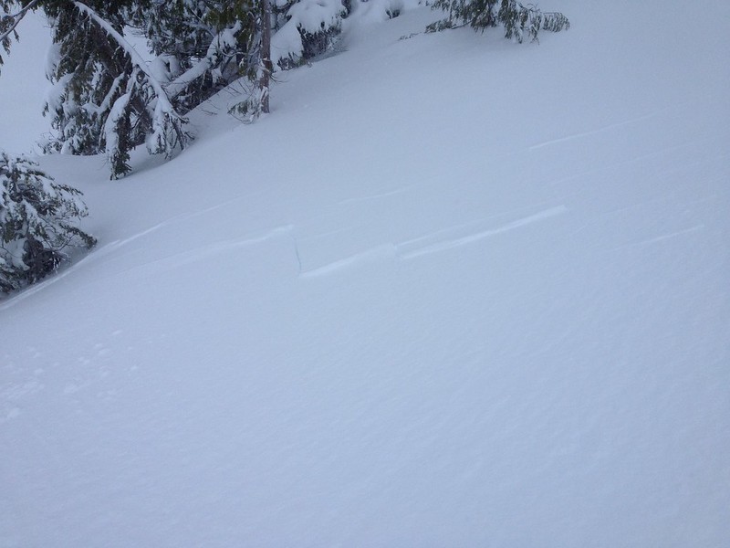
There were some decent turns to be had.

What's crackin'? The snowpack, that's what.
There were some decent turns to be had.

Thanks for the report Silas. Heading up there tomorrow, you gonna be there? Hope to see you in the snow or at least the lot! We should be there by at least 9. (It's Pat B)
Go dogs go! Quite a hound party up there first thing this morning (before "first" chair).
Good, smooth skiing on Upper Nash. Also reasonable cover on DD ridge above Sucker chute but we need at least another meter of fill-in to make lower BC terrain safe & enjoyable, especially outbound/inbound route via Source Lake.
Good, smooth skiing on Upper Nash. Also reasonable cover on DD ridge above Sucker chute but we need at least another meter of fill-in to make lower BC terrain safe & enjoyable, especially outbound/inbound route via Source Lake.
[img width=800]https://sphotos-b.xx.fbcdn.net/hphotos-ash3/9715_556511361029007_1786422736_n.jpg" />
We came back to Lower International to return to our car, the winter exit trail would be quite an adventure with the current amount of snow I think.
The Pass is called all those names. I just prefer the actual name of the park because it implies the jumping off and is generally more bad ass that Selmo Pass of Kootaney Pass.
Here are two more pictures from Dec 1., I just figured out how to post them.
Here are two more pictures from Dec 1., I just figured out how to post them.