TR Replies
Kevin Grove and a friend just recently skied a five peak traverse in like 3 hours ;-). Apparently on the same day as the above post....
http://cascadeclimbers.com/forum/ubbthreads.php?ubb=showflat&Number=1026057
http://cascadeclimbers.com/forum/ubbthreads.php?ubb=showflat&Number=1026057
I don't know if it has been skied in a day before.
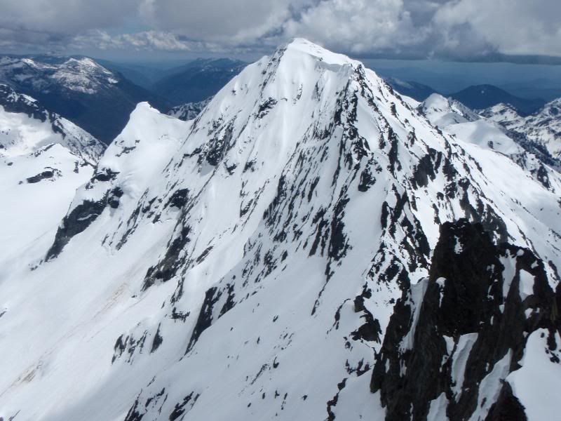
This 2009 NWMJ article by Kevin Grove described attempts to ski the route in a day. From the article, you get the impression that it hadn't been done yet at that time:
http://mountaineers.org/NWMJ/09/091_ThreeSisters.html
This 2009 NWMJ article by Kevin Grove described attempts to ski the route in a day. From the article, you get the impression that it hadn't been done yet at that time:
http://mountaineers.org/NWMJ/09/091_ThreeSisters.html
Nice! I've was sizing this one up for this season too but things never came together.
Way to ski outside the box! I've looked at this line a bunch- nice one!
its certainly been hiked more than a few times.... the Sisters 'marathon' was a pretty common summertime hike/climb among U of Oregon folk when I went to school there in the 90's.
I believe that the marathon has been done (on foot) sub-24 hours including the Sisters, The Husband, Broken Top, and Bachelor.
I believe that the marathon has been done (on foot) sub-24 hours including the Sisters, The Husband, Broken Top, and Bachelor.
Man, I am still salivating over this.
nice one fellas!
nice one fellas!
Cool guys!
I was wondering how it went for you this weekend. Glad you had a good trip.
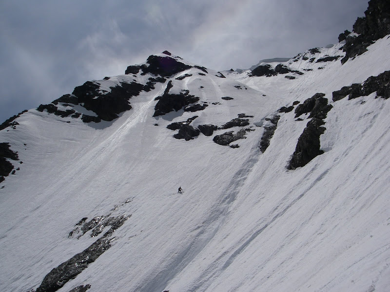
Looks like you only had a thin spot to cross through onto the lower slope before crossing the runnel? I had to scramble that section last year.
edit...
Oddly, I took a picture a week prior to riding it, that section was not yet melted out?
I was wondering how it went for you this weekend. Glad you had a good trip.
Looks like you only had a thin spot to cross through onto the lower slope before crossing the runnel? I had to scramble that section last year.
edit...
Oddly, I took a picture a week prior to riding it, that section was not yet melted out?
Thanks for the warm welcome.
Yes, I have been lurking for years. This site is inspirational, but to "turn all year" near where we live is but a dream.
Sorry about the meterage business. We were travelling light and I left the Suunto manual at home!
A link to more pictures may appear sometime soon, to inspire other lurkers to head up to Goat Rocks.
Amazing photos! Like the bike/ski combo to get in there. 8) 8)
author=telemack link=topic=21465.msg91918#msg91918 date=1310582945]
Where exactly is Columbia Peak?
SSE of Mountain Loop Highway's Barlow Pass:
http://maps.google.com/maps?q=columbia+peak,+wa&hl=en&ll=47.96648,-121.35498&spn=0.095744,0.222988&sll=37.0625,-95.677068&sspn=57.161276,114.169922&t=p&z=13
author=skiyak777 link=topic=21443.msg91810#msg91810 date=1310417008]
Road was impassable about 2 miles below the Cold Springs campground. The snowdrifts weren't that big (I'd guess you could get over them with a 4WD and they will melt quickly) but there are quite a few downed trees along the way, some of which are pretty large, so until the forest service removes them, it will require some hiking.
Hi - your post brought...
author=sierra_slider link=topic=21457.msg91878#msg91878 date=1310515410]
Skied the north face of Mt Maude on Sunday. Went up the west face and out via Ice Lakes. The snow on the north face wasn't quite soft enough to smooth out all the ripples, but it was still a fun ski. There were huge runnels on the lower half and plenty of rocks falling along the traverse (which, for that reason, we didn't take). The snow was well consolidated on all aspects--we...
amazing photos as always Jim! did you get a view of Blanca Lake, Columbia Glacier, Kyes? I was wondering if that might still be a worthwhile ski this summer given the ample snowpack still up high.
Great shots after a good adventure as usual, Jim.
Where exactly is Columbia Peak?
Where exactly is Columbia Peak?
Hey Silas, unless I missed it somewhere on here, you gotta explain the "testing Kam's skis" vid to us! Hilarious
Yes, kind of like a Facebook "wall" there on TGR?
By contrast, I sincerely do want to thank the OP and other TAY posters for their valuable beta at this time of year, given constantly changing road access, snowlines, suncups, crevasses issues, etc.
By contrast, I sincerely do want to thank the OP and other TAY posters for their valuable beta at this time of year, given constantly changing road access, snowlines, suncups, crevasses issues, etc.
author=jackal link=topic=21429.msg91765#msg91765 date=1310358861]
We went topside, to the west end off N side to the saddle. Beautiful day to just hang out on top with 360 views. Good corn but lots of runnels from saddle to Bagley Lakes. Silas you chose the primo run.
Thanks to Jackal for the great pics....
AND Silas, I apologize for not recognizing you, because you were not wearing the LEDERHOSEN that you had on Halloween, w...
Amazing and very, very inspiring! This is a very beautiful traverse...
What a fantastic TR, great pictures, and a fantastic story, so well written, and a great tribute. thanks
Nice Mack (and friends),
We would have enjoyed tagging along with you on this one. :)
I will have to say our weekend spent near sea level was interesting and satisfying. ;)
The "Deception" of what works and what doesn't is always intriguing. :D
I will be in touch,
Gary
We would have enjoyed tagging along with you on this one. :)
I will have to say our weekend spent near sea level was interesting and satisfying. ;)
The "Deception" of what works and what doesn't is always intriguing. :D
I will be in touch,
Gary
author=Jonathan_S. link=topic=21443.msg91860#msg91860 date=1310492910]
If you dare read the TGR East Coast thread, you will conclude that some people definitely can't ski (or bike, or kayak, or do pretty much anything) w/o posting!
I took your dare and was amazed at what I saw on that thread. What the hell is going on over there on the EC. Do they they post a TR about everything they do? Far worse than the TR narcissism...
author=rlsg link=topic=21416.msg91706#msg91706 date=1310244509]
What sort of open slope continous fall line-ish vertical is there to be had (not including the slog through the woods..)?
There is not much wooded terrain on the S sides; some log-hopping thru the Devastated Area.
If you connect the SE and S faces of Lassen you get a bit over 2000'. The NE face is still over 3000' from Emigrant Pass (have to access from N st...
author=alecapone link=topic=21440.msg91852#msg91852 date=1310488544]
Cool Mack!
You've been gettin down this spring.
Is it spring already? Snow level is back down to 7500' this week again. ::)
Thanks for the photos, Nick!
author=silaswild link=topic=21458.msg91886#msg91886 date=1310521835]
Welcome to TAY.
Yeah, howdy, northern neighbor. I checked your profile when I saw the elevation in meters.
5 years from registering to your first TR---don't wait that long to post the next one. ;D
Thanks for the report Chris, good to get up to date info on a great area. Snow looks nice and smooth on the ski slopes. :-)
Welcome to TAY.
Welcome to TAY.
Robie, great trip. When you say you left a 1/4 mile from the trail head does that mean that is how far you drove? When we did this a month ago there was snow almost 3 miles down the road. How far did you drive? Thanks,
author=trees4me link=topic=21457.msg91880#msg91880 date=1310515805]
beautiful!
That's a big day, how long did it take you?
530 from the car, returning at 630.
Would have been faster if we didn't waste time bushwacking across lower Leroy basin on the descent. Should have traversed across the upper basin instead of being lazy and following gravity into the jungle.
The west face couloir wa...
beautiful!
That's a big day, how long did it take you?
That's a big day, how long did it take you?
Lassen is pretty much always good. The summit is 10,500, the TH is 8,500 so that means direct access to the upper mtn. Another good thing about Lassen; there is a shoulder on the lower mtn trail that offers about 3 different sections(earlier, yields the most snow but holds snow till mid-Aug). * You can also ski the North aspect for about 700 vert and boot back up and do it again. And then you get the turns on the lower mtn, as well( back at the S side). The Park service is doing major repairs on...
Wow, thanks for all the great first-hand conditions update of the whole mountain. Looks like a good future objective..
GREAT PICS!
GREAT PICS!
Mack,
It was a great day to be out. Thanks again for pushing me to get out of town.
It was a great day to be out. Thanks again for pushing me to get out of town.
Peace brothers. Glad east coasters are reading how good it is out here.
A Mass. native and 29 year PNW resident.
A Mass. native and 29 year PNW resident.
If you dare read the TGR East Coast thread, you will conclude that some people definitely can't ski (or bike, or kayak, or do pretty much anything) w/o posting!
author=Jonathan_S. link=topic=21443.msg91857#msg91857 date=1310491076]Yes, the people who post trip reports are the only people out skiing.
I just wanted to note how proud I am as a Massachusetts resident about to fly out for a trip that will probably include the SW Chutes, that the most recent beta thereof is from a fellow Massachusetts resident.
(Get with it you PNW slackers!)
I just wanted to note how proud I am as a Massachusetts resident about to fly out for a trip that will probably include the SW Chutes, that the most recent beta thereof is from a fellow Massachusetts resident.
(Get with it you PNW slackers!)
(Get with it you PNW slackers!)
author=Dr. Telemark link=topic=21443.msg91845#msg91845 date=1310479807]
Did you skin up much of the approach, or was the snow consolidated enough to just boot up? Thinking of going this next weekend if the weather holds. Guess I won't be going solo based on the number of people already running up and down in your pics.
MT
I was able to start skinning shortly after Cold Springs (maybe 5500 feet) and kept my skis o...
I was up there the weekend of the fourth. Just to clarify what telemark said: "The schrund doesn't cross the Hogsback."
The old chute(s) is accessed from the hogsback by crossing hot crocks (a pile of rocks and dirt) and climbing straight up the slope to the summit ridge. There is no bergschrund anywhere near this route, although there is a volcanic vent that is in your fall line if you stray to far climbers right (east). There's a bootpack up to the hogsbac...
The old chute(s) is accessed from the hogsback by crossing hot crocks (a pile of rocks and dirt) and climbing straight up the slope to the summit ridge. There is no bergschrund anywhere near this route, although there is a volcanic vent that is in your fall line if you stray to far climbers right (east). There's a bootpack up to the hogsbac...
Thanks, Zap. Let's get on it somewhere locally; I enjoyed your TR from Dege (except ron j's laceration).
author=harpo-the-skier link=topic=21440.msg91843#msg91843 date=1310475849]
How is the 'shrund at the bottom of the Old Chute? Is that a different chute than people go up most years?
I am an experienced Sierra skier going solo on hood when the weather clears this Friday.
Also, if I were to drop my skis would the hogback above...
Glad to see that you checked another one off your list. ;)
Did you skin up much of the approach, or was the snow consolidated enough to just boot up? Thinking of going this next weekend if the weather holds. Guess I won't be going solo based on the number of people already running up and down in your pics.
MT
MT
How is the 'shrund at the bottom of the Old Chute? Is that a different chute than people go up most years?
I am an experienced Sierra skier going solo on hood when the weather clears this Friday.
Also, if I were to drop my skis would the hogback above crater rock be the best place to do so?
I am an experienced Sierra skier going solo on hood when the weather clears this Friday.
Also, if I were to drop my skis would the hogback above crater rock be the best place to do so?
I hiked up there that weekend! I was there. Sadly, I did not have my skis with me. Nice pics!
author=TomB link=topic=21445.msg91830#msg91830 date=1310444059]
Fun times! And for anyone wanting to perfect their ski walking technique, here you go: http://video.google.com/videoplay?docid=-4602667877924488430#
Oh. Em. Gee. Tom, that video is FULL of win!
thanks! I knew I had to trek my SLR up there, after reading previous TR's about how beautiful it is :) Now I just have to go through the other 300 pictures ! Many thanks to the Friends of HLL for such a magical place to stay
Great trip!
To me, this sort of trip represents the future of ski mountaineering. In Fifty Classic Ski Descents of North America the authors asked the contributors, "How do you see the sport evolving?" My answer (before they edited it down) was:
To me, this sort of trip represents the future of ski mountaineering. In Fifty Classic Ski Descents of North America the authors asked the contributors, "How do you see the sport evolving?" My answer (before they edited it down) was:
In the mountains of North America, or at least in the Lower-48 States, it won’t be long before most of the classic lines that can be skied will be skied. For skiers seeking new challen...