TR Replies
author=KickSteps link=topic=36718.msg149709#msg149709 date=1469766797]
Mike: Lets do some aerial photography of your engineering projects, so you get to ride in a Bell 206 - the helicopter you saw on the road. ;)
What! That sounds awesome!
About time, Silas. I thought you said you weren't going to ski anymore in July . . .
author=runningclouds link=topic=36742.msg149711#msg149711 date=1469815019]
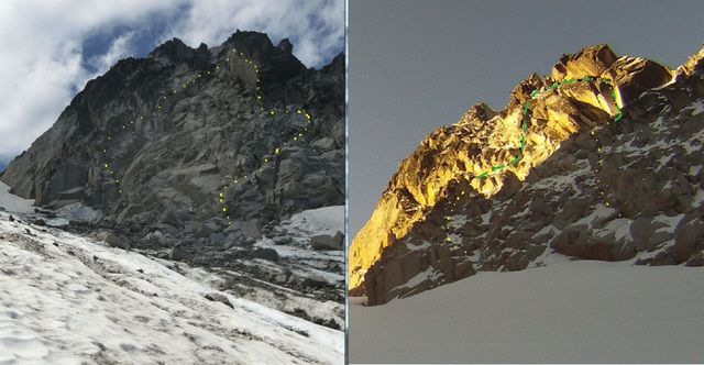
johnyutah can you post a photo with your route drawn on it?
Good timing, we arrived at Schriebers Meadows on Saturday around 3PM and it was raining and cloudy. I can hardly believe your pics, what a difference few hours make. It was a bit more festive on Sunday, there were 6 skiers on Squak and 2 on Coleman Deming. Happy skiing.
johnyutah can you post a photo with your route drawn on it?
Congrats! Any pictures anywhere? Were you able to skin up all the way Silas?
Mike: Lets do some aerial photography of your engineering projects, so you get to ride in a Bell 206 - the helicopter you saw on the road. ;)
Is that Mike on the Misery Whip!? Way to Buck! In Highschool, we did that for PE Class! and thank you for the trail maint...most appreciated!
Most excellent! Glad you finally got er done. Congrats to both of you.
No, it was closer to a month ago. They skied central Mowich, and there was also a group skiing Edmunds around the same time (RMI guides on that one).
I'd sure like to visit that side some time!
I'd sure like to visit that side some time!
author=kamtron link=topic=36742.msg149686#msg149686 date=1469549973]
Sicky-sick sick.
At least the 2nd central Mowich descent of the year---a good season!
We could make out three old tracks on the glacier below the face and thought they must have been a week old or so. ?? Is this the group you know of? did they ski the mowich or edmunds or both or just low?
a few more shots for those interested.
Wow, awesome, sounds like really great conditions.
I suppose I am a skier for most of the day :)
Here's my contribution to the photodump: https://flic.kr/s/aHskDWPkxZ.
My favourite shots of Martin:


Here's my contribution to the photodump: https://flic.kr/s/aHskDWPkxZ.
My favourite shots of Martin:
Nice report Mike. Still looks nice up there. I was up there last year earlier before my hip got totally fried (but without skis) and had a good solo trip. Went over the top and into the Chiwawa Basin by traversing down on some ledges and popped over Red Mountain. This area is one of my favorites from Wilderness Ranger days long ago.
V. nice write-up, and sweet send! Completely empathize with that leg- and will-sucking grind up the "talus" to gain the ridge after a long day...
Could you please share another pic or two of that side of the mountain, from other vantages? E.g., in addition to the nice frosty-white one from lower Ptarmigan Ridge, do you have any from higher up, or from the N Mowich Gl (presumably your camp)?
Could you please share another pic or two of that side of the mountain, from other vantages? E.g., in addition to the nice frosty-white one from lower Ptarmigan Ridge, do you have any from higher up, or from the N Mowich Gl (presumably your camp)?
Sicky-sick sick.
At least the 2nd central Mowich descent of the year---a good season!
At least the 2nd central Mowich descent of the year---a good season!
Kaston - Ha! Didn't know you'd be reading my post. I'll get it right next time :)
Martin - Funny to think I was using you post and photos as beta all while camping right next to you. You took some awesome photos!
Did you guys manage to find any tasty food on the way back? We stopped at Bob's Burgers & Brew in Burlington.
Hope to run into you both again.
Martin - Funny to think I was using you post and photos as beta all while camping right next to you. You took some awesome photos!
Did you guys manage to find any tasty food on the way back? We stopped at Bob's Burgers & Brew in Burlington.
Hope to run into you both again.
Damn that seem's like a good year. Shasta and Rainier and who knows what else !
Keep it up!
Keep it up!
Thanks for the report. All the pertinent data. I like it when it gets warm enough (for me) to swim at Peggy's Pond. You are probably tougher than me in that regard. That steep chute getting thin, I've backed off it when the thin became scary and I was afraid of falling in a hole. Probably time to start watching that.
Impressive work guys, thanks for the TR!
Thanks all. Probably a couple weeks left, go get it!
The skiing was still pretty good this weekend (23-24 July) but the glacier is not as smooth as 10 days ago, largely due to rain. As mentioned there was significant sloughing on the South portion of Roman Wall at noon. In my view this was because there is still unconsolidated water soaked layer that will benefit from few days of melt/freeze. It might get better soon.
Nice to meet fellow skiers at the summit!
https://www.flickr.com/photos/runningclouds/albums/721576714672054...
Nice to meet fellow skiers at the summit!
https://www.flickr.com/photos/runningclouds/albums/721576714672054...
Great write up - way to grab a king line in killer conditions!
I ascended along the margin of the Klickitat Glacier Sunday, too. The wild east side has shed most of its friendly winter coat.
Any SAR-connected people know where we might contribute our Sunday GPS track to the searchers? Please email/PM (This email address is being protected from spambots. You need JavaScript enabled to view it. )
Support your local SAR teams -- these big searches demand so much effort and sacrifice.
Any SAR-connected people know where we might contribute our Sunday GPS track to the searchers? Please email/PM (
Support your local SAR teams -- these big searches demand so much effort and sacrifice.
Charlie, I spoke with a SAR person who was there on Sunday. One theory is that the missing climber may have descended east/southeast in the whiteout from the summit instead of returning down the south route. But, they just don't know.
Nice meeting you all, it is a small world, or as someone on the summit said: это маленький мир!
I will post a bigger version to my Flickr later.
I will post a bigger version to my Flickr later.
Inspiring descent, and well timed. Good luck with your next trip!
Great pics! It was nice to meet you guys up there. Runningclouds and I are the two you're talking about. But don't call me a skier :)
We summited Sherman & Grant via the Squak Glacier yesterday (7/24). We used this report and runningcloud's photos as beta, but were a bit confused about the description of the icefall above 8500'. We headed left around the a large icefall right below 8000' but other than that didn't run into any issues. There were a few small cracks but nothing impassable. The roman wall similarly had some crevasses starting to form but nothing major. We did...
Certainly a fun day. Thanks for the write-up. Here is an after/before pic. The before is from November of 2011.
And a couple ski pictures. It really was fun skiing!
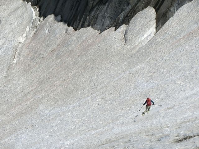

And a couple ski pictures. It really was fun skiing!
That was awesome!! Thank you for posting all those pics. Can you post the entire video? I've skiied from the summit down west crater rim all the way to the highway. Always dreamed of skiing the Sandy Headwall. What you did looks much scarier.
Great writeup! Fun to read and good photos.
Nice writeup, Jim. I especially enjoyed the old Couloir pics. Coombs!
author=mikerolfs link=topic=36728.msg149603#msg149603 date=1468687278]
I also looked at your smugmug photos. What kind of tele set-up are you using? Looks like a duck-butt with pin toes
This was super confusing for a few minutes. What type of tele-photo lens has anything that looks like a duck-butt ?? :)
Great photos as always - thanks for sharing
Erik
Excellent news. Did you ascend directly from Morrison Creek, through the campground, or drive in the morning to Cold Springs? Cheers
author=GoodVibesOnly link=topic=36734.msg149629#msg149629 date=1468899252]
We camped at Morrison Creek Thursday night to avoid the Cold Springs mayhem and drove up the final couple miles in the morning. I'm surprised more people don't do this on busy nights as the camping is soooo much nicer below. Not to mention much less car traffic rolling through at night.
I've wondered about that, too. But, I'v...
Looks like a great day in the mountains. I like the black and white spooky stair case. Looks like it could be from a fairy tale.