TR Replies
Rainy pass side is still good to go as of yesterday (might be changing now). I'd guess about a foot at the pass - road was driveable in a low clearance awd without much concern. Very brushy getting to the trialhead / lots of car scraping
a few more pictures over the next few days with better visibility


author=thatcherk1 link=topic=37073.msg150555#msg150555 date=1479573052]
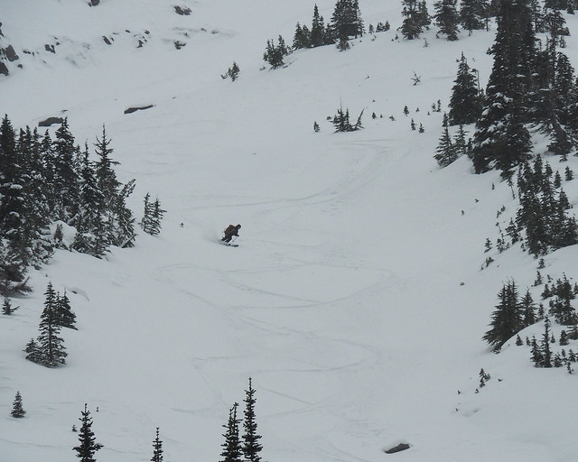
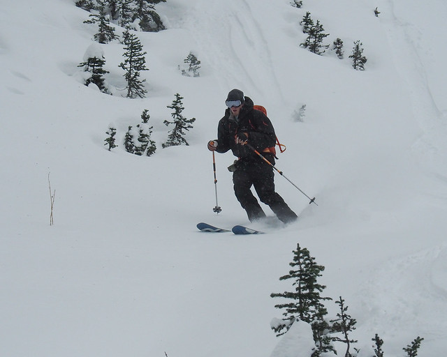
Spend the day with Jim doing a couple laps up on Heliotrope. There were stashes of really nice pow, but most of it was wind-affected. Not too bad though. All the snow was fun, and none of it was difficult, but only some of it was glorious. There was 1-2ft of fresh snow. Wind was blowing hard, and the mountain was starting to sock in around 1pm, causing us to abandon our plans to ski until...
despite the wind, it turned out to be a pretty fun day. thanks carl & jeff for breaking trail and scott for convincing us to do a third lap, which turned out to be the best. i should've brought more whiskey!
Venturing away from well traveled and established in/out routes not recommended with the low coverage.
Also, found a pair of poles - http://www.turns-all-year.com/skiing_snowboarding/trip_reports/index.php?topic=37084.0
Also, found a pair of poles - http://www.turns-all-year.com/skiing_snowboarding/trip_reports/index.php?topic=37084.0
^ yeah! inquiring minds need to know. inquiring minds who live a 5 hour drive away and want to pillage all your pow!
It was good to see other old people but you left just as the snow got better ;)
Thanks, all, for a great day out. It was very fine to sample the new season's snow. While fresh and soft, it's heavy enough to be great base material. Given the shallow height of snow, it was impressively supportive.
We didn't venture far above the treetops, but where we did, ridgetops were scoured and lee slopes held 1F windslab. At least on the long E ridge of Naches, the south side of the ridgetop was scoured, while the north side held some loading.
The s...
We didn't venture far above the treetops, but where we did, ridgetops were scoured and lee slopes held 1F windslab. At least on the long E ridge of Naches, the south side of the ridgetop was scoured, while the north side held some loading.
The s...
Looking at the timestamps of my photos, we were at the top of our last run at 2:15 when the wind was, subjectively speaking, the strongest. At 2:30 the wind has completely died down and the clouds started to move in, there was likely a short window of opportunity for another run but we were happy with the day and tired from fighting the wind. By the time we hit the treeline the visibility was down again.
My estimate for Heliotrope was 40 mph winds with gusts up to 60 mph. I wished I h...
My estimate for Heliotrope was 40 mph winds with gusts up to 60 mph. I wished I h...
author=thatcherk1 link=topic=37073.msg150569#msg150569 date=1479628393]
That dog was precious. I was sad I didn't bring my Sammy up there. Did the clouds sock in completely, or did they stay high? I really wanted to ski the skiers right side, direct up from hogsback. But we were lazy and followed a couple trail-breakers to lightning rock for a couple laps.
We just did one lap - the ceiling was dropping and the winds were blow...
It's funny, this day started out with high ambitions to very low ambitions due to the high winds and wind slab building on our objective. Then a little of Ben's fine bourbon and a few little Pow pockets, on lee trees, had our ambitions rekindled.
We ended up finding some good 1200vf protected gullies. With weak legs after a few laps our ambitions were lowering, but Alas Scott's ( with his later arrival) ambition level higher than ours, (and us not to deny his meter). So up...
We ended up finding some good 1200vf protected gullies. With weak legs after a few laps our ambitions were lowering, but Alas Scott's ( with his later arrival) ambition level higher than ours, (and us not to deny his meter). So up...
Sweet pics Scott!
Thanks for showing up and making us do another lap :)
Here is some video from the day and the day before
https://vimeo.com/192287222
Thanks for showing up and making us do another lap :)
Here is some video from the day and the day before
https://vimeo.com/192287222
That dog was precious. I was sad I didn't bring my Sammy up there. Did the clouds sock in completely, or did they stay high? I really wanted to ski the skiers right side, direct up from hogsback. But we were lazy and followed a couple trail-breakers to lightning rock for a couple laps.
Can someone explain what is the deal with the road? Will NPS keep opening it for the weekends as long as there is no snow on the ground?
I was there too - part of the group that thatcherk1 skis by towards the end of his video (we were a combined group of five, plus a dog).
Snow was much better than I thought it would be considering the wind was so strong it almost knocked me over a couple times on the way up.
We ended up cowering below the rock at the top with a bunch of hardcore Canadians while we transitioned. Apparently going goggle-free is a thing north of the border. ;)
Best skiing was straight up from Hogsback. Discostew and I started lookers right and with each run moved lookers left and every run was an improvement (i.e less wind affected, more powdery). The skiing was great but the wind was difficult; it stopped completely around 2 PM as clouds moved in. The trail had areas of verglas and few falldowns since our first trip on Oct 22. Great day to be out.
https://www.flickr.com/photos/runningclouds/albums/72157672131356284
https://www.flickr.com/photos/runningclouds/albums/72157672131356284
We were up there yesterday too. I'm the splitboarder that briefly spoke to the guy in a blue jacket with the helmet and sunglasses. Windy as balls out of the south above ~1900m. The kind of wind that makes it hard to think straight. We managed to find some not completely wind-f@#ked snow below 1900m. I was quite pleased.
https://vimeo.com/192271857
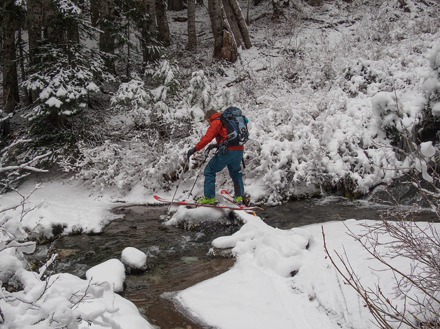
Road drivable to the trailhead with an inch of packed snow in the parking lot, s...
https://vimeo.com/192271857
Road drivable to the trailhead with an inch of packed snow in the parking lot, s...
That looks great! These early winter days when the roads are still open are so nice.
Yes, you can skin/ski all the way to the parking lot -- it's bony, but nothing a little fancy maneuvering can't handle.
Northeast wind was steady with some pretty strong gusts through Pan Point and a little beyond then stopped with complete calm for 30-45 minutes before it came in strong again from the southwest bringing in low visibility. Made it to Muir. Ate lunch. It was cold.
Before heading down, visibility drastically improved with a dramatic sky and views of...
Can you ski/skin all the way to/from the parking lot?
Wow, bottomless powder ! we were less than 1/2 mi. from you and only had boot top at 6500' to 5000' an a firm base with air pockets an rock encounters toward the bottom . Looks like you found skiers nirvana . X
Thanks for brightening up a h.s teacher's day! Stevens will be as far as I make it this weekend. Indeed, from the photo, the snow was "very nice"!
Nice score - the highway closes this morning!
"It was like the snow simply slipped vertically from the wings of angels." ah, true poetry. Dod, you have such a way with words.
I've been looking for a while, I think if you could time it right there are good options up Little Wenatchee River Rd and maybe Chiwawa but its a matter of timing mountain vs valley snow and gate closures.
Or just drive to Washington pass.
Or just drive to Washington pass.
Sweet! Early season is slim Pickens on highway 2. Even if you are willing to pay the price.
Any idea how much snow at smith brook's rainy pass? I did the west face from Smith Brook(snow Creek) side a few weeks ago. Highly recommended over the south if you can get there. 2'000'+ of perfectly pitched* slopes with nothing but grass. Bareley a rock or shrub... entry fee is less, and more enjoyable too.
Seen another set of solo tracks coming from the south rout...
2000' straight up from the car? Pretty reasonable price for the snow in those pictures! Nice work DOD!
Sunset descents up there before strict gate closures are a treat. The light can be sublime.
Thanks for sharing!
Thanks for sharing!
the best kind of walkabout :)
Really nice vid and skiing. WOW. Thanks!
Wow guys, way to get after it! Looks nice!
Awesome! I thought the road to the white river campground was closed though? Or is it not gated?
Mack:
The Ridge phone message says "weather permitting the Ridge Rd. is open 24 hrs a a day. The park web site says the road may close on short notice due to weather or unsafe road conditions. Possibly personnel changes this winter season so stay tuned!
All the warmth and rain over the last couple of weeks is taking its toll on the early snowpack especially on the high peaks on the periphery of the park, eg. Elk, Victor, etc. Having said that I was happy...
Are you from the future? Who wins the election?
Oops looks like this post doesn't say November 11 anymore....
Oops looks like this post doesn't say November 11 anymore....
Doug, good effort at HR again. I've been watching the snow level in the Olympics creep upwards.
Too much rain in the wrong places!
Your link to Google photos would not open.
Is the HR road now only open Friday through Sunday?
Too much rain in the wrong places!
Your link to Google photos would not open.
Is the HR road now only open Friday through Sunday?
Thanks snoholic, and my apologies too, runcle, for the drift. Good you both got out and got some turns. Didn't look so windy from a distance, but obviously was pretty gusty both days!
Sorry for the threaddrift Runcle. The road is passable by a Prius with slicks currently if desired. We were going for the summit and took a direct line up. The C/D route had many open creavasses, glacier gear recommended. From what I could see the more popular area of Helio was pretty filled in. Lots of people on Helio.
Snoholic, just wondering how was the road? Will fwd car with snows make it to the trailhead, or awd needed? Crevasses nice and visible? Thanks.
We had to literally crawl down the hogsback below Heliotrope today or be blown into the abyss. Skiing up high was good tho.
There are a couple shots of the trip I took with Ben last weekend up Rainier on my Instagram if you wanna have a look.
https://www.instagram.com/caseymommer/
https://www.instagram.com/caseymommer/
Second what Charlie said, TAY is a useful archive. TR value is diminished when the image links rot away. If I wanted my TRs to disappear the next day I would just post to FB.
The great thing about TAY-hosted images is that they are largely immune to link rot. You can go back to 2004, and most photos are still there.
Just upload your pictures somewhere like imgur or flickr and link them with the img tag
TAY shouldn't even offer to host images when there are plenty of free, high-quality alternatives out there.
TAY shouldn't even offer to host images when there are plenty of free, high-quality alternatives out there.