TR Replies
lrudholm, couldn't hear you scraping, but I hope you got down to Headlee before we summited. I wished I had skis for the long traverse over there! Did you see someone climbing the standard route on Sperry? We found footprints at the summit.
Hey Kyle,
What crampons are you using with your snowboard boots? BD's?
What crampons are you using with your snowboard boots? BD's?
Awesome! Thanks for posting. Makes me wish I had taken better advantage of this uncommon combination of high elevation snow pack and access.
author=JimD link=topic=14771.msg61821#msg61821 date=1260380783">
Thanks for another great TR and photos. I've taken the liberty of using one of your Sperry shots that inspired me to climb it last weekend in my TR here.
Ah ha! You guys were the ones in the subaru at the trail head. We skied Vesper that day. Maybe you heard our skis scraping down the ice from...
Nice work -- loving the blog you've got going. I'll be putting it on my list for "bored at work surfing".
Jim D-That climb looked really fun and I'm stoked that a picture of mine was an impetus! Thanks
Jim H-Yeah it was a long day for one of the shortest days of the year. It's great to be able to take advantage of this high pressure though. As soon as it snows everything will be dangerous for awhile and I'll be resting up a bit more then.
Jim H-Yeah it was a long day for one of the shortest days of the year. It's great to be able to take advantage of this high pressure though. As soon as it snows everything will be dangerous for awhile and I'll be resting up a bit more then.
Thanks for the posting! Took the day off yesterday and shot up for 3 laps. Very enjoyable given the conditions...
http://picasaweb.google.com/TrevorL.Williams/EastPeakCrystalBC#
http://picasaweb.google.com/TrevorL.Williams/EastPeakCrystalBC#
JimD - thanks for cross posting! The summit shots are great.
cons - that's a big day. Way to get at it, thanks for sharing the photos.
cons - that's a big day. Way to get at it, thanks for sharing the photos.
Thanks for another great TR and photos. I've taken the liberty of using one of your Sperry shots that inspired me to climb it last weekend in my TR here.
Thats the way I went when I toured there. Never went near Comet falls and the alternate route seems pretty avy safe.
The scree field was buried. That was where we ditched the hiking boots and bootpacked the first bit to get above the brush line, then skinned from there.
That made me shiver a little just reading it. Way to take advantage of this high pressure while it lasts. Great TR/photos.
author=Snow Bell link=topic=14715.msg61809#msg61809 date=1260347469]
Chris- Like Kyle said; with much fresh snow, there seems to be little chance of a safe route...
Burgdorfer shows an alternate route (to the left) around the terrain trap for higher avy conditions.
Ambitious for sure. I am supprised that the gate was (is?) still open. Was anyone else up there? When does it close?
I had planned to do the loop last spring but the bridge closure impaired my resolve. I hiked it this summer and have since modified my intended approach.
Jeff- I'm sure that you know but that is a long road. I had considered riding from the hwy but even in a car it keeps going and going and going. Not undoable by any means b...
Nice write up on the blog Kyle. It was fun chasing you up there. I am drinking lots of beer to carbo load for the next time we get out. ;)
Chris- Like Kyle said; with much fresh snow, there seems to be little chance of a safe route. I may wait for firm conditions again although not quite as firm as we found that day.
Chris- Like Kyle said; with much fresh snow, there seems to be little chance of a safe route. I may wait for firm conditions again although not quite as firm as we found that day.
Pretty cold weather for that one.
May I assume since you didn't mention the scree field that it is pretty well covered?
That part is just insult to injury after the hike up to it.
Thanks for the photos.
May I assume since you didn't mention the scree field that it is pretty well covered?
That part is just insult to injury after the hike up to it.
Thanks for the photos.
Looks fun.
I read an article last summer in the Oregonian that they (Forest Service) is considering banning kites from Wilderness areas. The article was about a group out of Bend Or that has been kite boarding in the 3 Sisters wilderness. The groups against kite boarding are using the mechanized travel clause that also bans bicycles from wilderness areas.
I read an article last summer in the Oregonian that they (Forest Service) is considering banning kites from Wilderness areas. The article was about a group out of Bend Or that has been kite boarding in the 3 Sisters wilderness. The groups against kite boarding are using the mechanized travel clause that also bans bicycles from wilderness areas.
This report reminds me that hope springs eternal. Even down lower at the elevation of Hyak, the mid-day sun didn't do much but bring us a little cheer as we sat and ate our lunch.
Smith Brook always gets early season snomo traffic until the snowbanks are plowed up enough to keep them from getting off the road, it seems. Pray for snow!
Great report, but a bummer to hear of the sled traffic on Smith Brook Road. I haven't been up there for a few years but cannot remember snowmobiles in the past. I do remember lots of snowshoers and it seems it used to be the most popular non-motorized non-developed access point near Stevens pass, except for Skyline Lake. It would be a shame if non-motorized users are pushed out.
Where did you get out to Jason? Did you find good snow? I saw some nice reports from the Duffey on certain aspects...
Stoked, the first shot is looking SW. The Rutherford unload is at about 4km. The trail in is a whoop fest, mixed with deep cr. crossings (enough to bend a tunnel on a 144"), glare ice, holes, and is getting icier with each passing sled. They have not yet begun grooming. Once past the emergency cabin, it's a bit icy to Appa toe, then good to go. I think it was...
Stoked, the first shot is looking SW. The Rutherford unload is at about 4km. The trail in is a whoop fest, mixed with deep cr. crossings (enough to bend a tunnel on a 144"), glare ice, holes, and is getting icier with each passing sled. They have not yet begun grooming. Once past the emergency cabin, it's a bit icy to Appa toe, then good to go. I think it was...
Juan, There had been more sled traffic north of Rainy Pass but snowmobiles had definitely been using the Smithbrook Road on the five miles between Hwy 2 and Rainy Pass. I wasn't aware that there was any type of snowmobile closure on the road there. Can you fill me in on the details?
author=telemack link=topic=14759.msg61756#msg61756 date=1260279638]
It's nice to see a report from the White Mountains. Looks like you you could use some filling in too.
ya, it's nice to spread the white's love around a bit. was back up in the ravine today skiing in a raging wind whipping snow storm. there was ok viz though. intentionally got a pocket to pull out of left gully. not too big, and didn't run too...
I've always been impressed kite skiers. Holly and I used to love watching them at the Col du Lautaret when we were over there. Here is a video we took: http://www.travelpod.com/travel-blog-entries/sethandholly/europe-2005-06/1173609240/tpod.html
Scroll down to "kite skier video". That guy would get some serious air.
Scroll down to "kite skier video". That guy would get some serious air.
Nice effort, and given the weather and snow as good a bet for decent snow as anywhere. One question: was the snowmobile traffic to the south/west of rainy pass? There's not supposed to be sled traffice from Hwy 2 up to Rainy pass....
"My highest jump on the mountains was somewhere around 50' "
SWEET!!! :D
Great report
SWEET!!! :D
Great report
The kite pictured is a 2008 Ocean Rodeo, Rise 12m^2. (you asked what size sail I used, ypu must have done some windsurfing at some point)
I have been waiting for this weather system for a while. If you look at my other post: http://pskite.org/viewtopic.php?f=3&t=4225 you will see the development of this trip, including a trip up there w/o wind. I knew I just needed to wait for a high pressure system which creates these cold artic outflows through the fraiser river val...
I have been waiting for this weather system for a while. If you look at my other post: http://pskite.org/viewtopic.php?f=3&t=4225 you will see the development of this trip, including a trip up there w/o wind. I knew I just needed to wait for a high pressure system which creates these cold artic outflows through the fraiser river val...
Way to go in the not so stellar snow conditions!
Guess this works well with artic outflow.
Can you give an estimate for windspeeds?
Guess this works well with artic outflow.
Can you give an estimate for windspeeds?
It's nice to see a report from the White Mountains. Looks like you you could use some filling in too.
Hey Toby, in the first shot, which direction is that? How far up Rutherford did you drive before unloading?
An inspired choice! I would never had guessed. Well done!
Inspiring as always! Great TR
Way to go find those few feet of good turns. Glad to hear someone got them!
Way to go find those few feet of good turns. Glad to hear someone got them!
Chrism: Yeah that was us, being our first time up there, we thought the creek would be more direct. The trees were the way to go and that's the way we went down. But going up and down the sub-peaks before the main one was the highlight of the day since skiing wasn't a highlight, and we had plenty of time, so it was a nice way up.
Trumpet: Good one!
Trumpet: Good one!
We were a group of two on tele. The only others I saw where on snowshoes though I did see one set of skinny ski tracks, but not the skier who put them down (looks like they stuck to the road rather than the "clear" cuts).
With the 'woods route' that we used the one creek was easy to cross since the water was shallow and the snow walls around it not tall yet. It's also faster than using the road the whole way and gives a chance for some steep skinning. Glad you...
With the 'woods route' that we used the one creek was easy to cross since the water was shallow and the snow walls around it not tall yet. It's also faster than using the road the whole way and gives a chance for some steep skinning. Glad you...
Great photos. You must have arrived at the ridge a bit before us, getting the best of the day's light. Were you the group who went directly up the creek to the saddle? The debris in the gully looked challenging so we stayed in the trees climber's right of the creek.
A friend and I did exactly the same thing -- good chance we were the other 2 skiers you saw on your way down. Entertaining conditions, to say the least, but it beats cleaning the garage :-)
nice..my and a buddy where there as well (were you guys the group of ~4 on tele?)
agreed with your assessment! we were also surprised by the conditions, but no complaints here. The snow quality was true blower. We found the layer underneath to be quite hard, but with the new snow the sking was enjoyable.
It was very cold for sure. We also had a few interesting creek crossings, reminding us that it is still "early season".
This was my f...
Nice report!
Other than the approach, who needs skins?
I would really like to do this someday.
What size is your sail?
How did you anticipate the wind direction for that long hike in?
What if the wind was coming downslope when you got there?
I imagine that you have to have some pretty good skill so you don't get launched off the snow 30 plus feet!
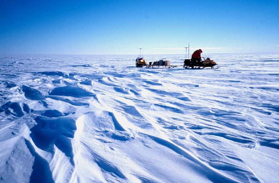
author=TobyT link=topic=14742.msg61663#msg61663 date=1260145865]We skinned up in a mixture of bubble ice, rime, knee high sastrugi, windboard, chickenheads and waist deep powder.
"sastrugi"?
explain please
I just returned from Canada as well...and my face is still thawing out. Nice work getting out there...must get to the Pemberton soon.
The last pic makes it look like you rode your sled to Nepal.
Nice TR!
Nice TR!
Thanks for the tip. I think I have figured out the general area that you are talking about for the "old lahar area". I was just talking with another guy and he said the best kiting location is the Plains of Abraham. I'll have to get up there and do some exploring and climbing.
did the walk down Mazama just a few days ago! Oh, and I cut firewood yesterday, too windy today!
There is an open area between the treeline and the steeper slopes, right around where the Loowit trail crosses the climbing route. You can see it (from above) in the second photo I posted, and in the first picture that DG posted. I think that this is between 4-5,000' and 2-3 miles in. Some map work (that I'm too lazy to do) could probably give you the exact numbers.
For what it's worth...I've never kite boarded, so I don't know how much space you need. But yo...
For what it's worth...I've never kite boarded, so I don't know how much space you need. But yo...