December 5, 2009, Longspur Peak, BC
12/5/09
Canada BC
6176
8
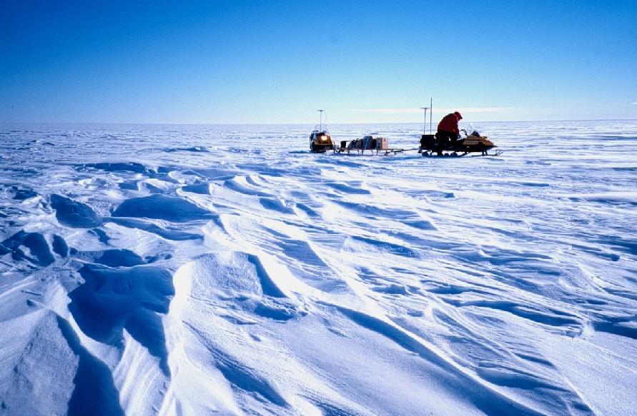
Longspur Peak juts out of the Pemberton Ice Cap and tops out at approx. 8500'. Stacy and I started out on an icy, bumpy, dangerous, sled track and got worked over in the process. When we finally made it to the alpine the day was half over. There are many, many open crevasses this early in the season even with the big snows that the region has had...In fact, just last week, a woman drove her sled into one, broke her nose and got a concussion. So, we clipped along at a modest 20-40 mph to the base of Longspur Peak. Just being out there, in that expanse, makes you feel very small. This, combined with bone chilling cold and high, gusty winds just adds to that feeling. We skinned up in a mixture of bubble ice, rime, knee high sastrugi, windboard, chickenheads and waist deep powder. Given such a late hour so far from Kansas, we forwent the rock rimed summit a mere 50 meters elevation away. Winds were gusting an estimated 50 MPH and temps. were in the single digits. The snow plumes trailing off of surrounding peaks were surreal. The ski down was everything to be expected of a high alpine peak in winter, with no new snow and howling winds. However, we did find some pockets of wind packed powder and those turns made it as good as the Brown Shugga' (American Strong Ale 9.85%) we enjoyed ...http://beeradvocate.com/beer/profile/220/2264/
Nice Toby -- great pics as usual.
The last pic makes it look like you rode your sled to Nepal.
Nice TR!
Nice TR!
I just returned from Canada as well...and my face is still thawing out. Nice work getting out there...must get to the Pemberton soon.
author=TobyT link=topic=14742.msg61663#msg61663 date=1260145865]We skinned up in a mixture of bubble ice, rime, knee high sastrugi, windboard, chickenheads and waist deep powder.
"sastrugi"?
explain please
thanks!
nice glossary link, too!
nice glossary link, too!
Hey Toby, in the first shot, which direction is that? How far up Rutherford did you drive before unloading?
Where did you get out to Jason? Did you find good snow? I saw some nice reports from the Duffey on certain aspects...
Stoked, the first shot is looking SW. The Rutherford unload is at about 4km. The trail in is a whoop fest, mixed with deep cr. crossings (enough to bend a tunnel on a 144"), glare ice, holes, and is getting icier with each passing sled. They have not yet begun grooming. Once past the emergency cabin, it's a bit icy to Appa toe, then good to go. I think it was 20 miles to the base of Longspur. If you like the looks of this picture, give it a go! I won't be back until there is more snow and grooming of the road section.
Stoked, the first shot is looking SW. The Rutherford unload is at about 4km. The trail in is a whoop fest, mixed with deep cr. crossings (enough to bend a tunnel on a 144"), glare ice, holes, and is getting icier with each passing sled. They have not yet begun grooming. Once past the emergency cabin, it's a bit icy to Appa toe, then good to go. I think it was 20 miles to the base of Longspur. If you like the looks of this picture, give it a go! I won't be back until there is more snow and grooming of the road section.
Reply to this TR
Please login first: