TR Replies
Thanks for the heads up to check this out Brian. Looks awesome!
No Leyland, no hardrock. I made that name up. Just keeping with the theme. pretty rowdy looking.
Stefan,
I seen that report when Yana posted it. She had a few good ones from the area last fall.
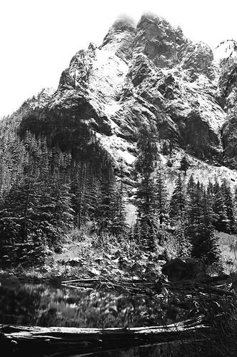
Get's a little confusing with 3 peaks, but I am not sure that is the line I was heading up. It looks like that is between the middle and north peak? wish I could have seen more.
Smooth jazz is between east and middle dropping north.
Stefan,
I seen that report when Yana posted it. She had a few good ones from the area last fall.
Get's a little confusing with 3 peaks, but I am not sure that is the line I was heading up. It looks like that is between the middle and north peak? wish I could have seen more.
Smooth jazz is between east and middle dropping north.
author=Kyle Miller link=topic=20070.msg85223#msg85223 date=1299692383]
It seems this website is getting a little bit off track so I thought I would post up some of the stuff I have been doing lately.
Yes, this is great. Back to the basics in an extraordinary way. Beautiful stuff! Thank you Kyle Miller.
Looks nice!
So there is the Jazz couloir and the Hard Rock couloir off of Baring?
Glad you made it up there.
So there is the Jazz couloir and the Hard Rock couloir off of Baring?
Glad you made it up there.
i've wanted this line too.
went up on recon to snow coated devils club. retreated to cat tracks on top of our own.
cool.
Did you guys make the notch? I've never done that east facing line. I've made squiggles down the west side. We were able to link up the white stuff from the big basin down the north side to the old road bed that the climbers trail starts on. 1998 or 99 I think.
Good work - I rode chairs for an hour ;)
Good work - I rode chairs for an hour ;)
Thanks!
you are probably more into hard rock?
Lol at MArcus. (sorry)
I remember that from last spring. I don't even have to look.
agreed re the debris. I had no intentions of going up until I seen it, among other variables. You could probably work around to the east to avoid most of the exposure at the bottum, and then cut in. Almost all the action is c...
Looks familiar!
http://www.turns-all-year.com/skiing_snowboarding/trip_reports/index.php?topic=16083.0
Bit drier and snowier in your pictures... huh. ;)
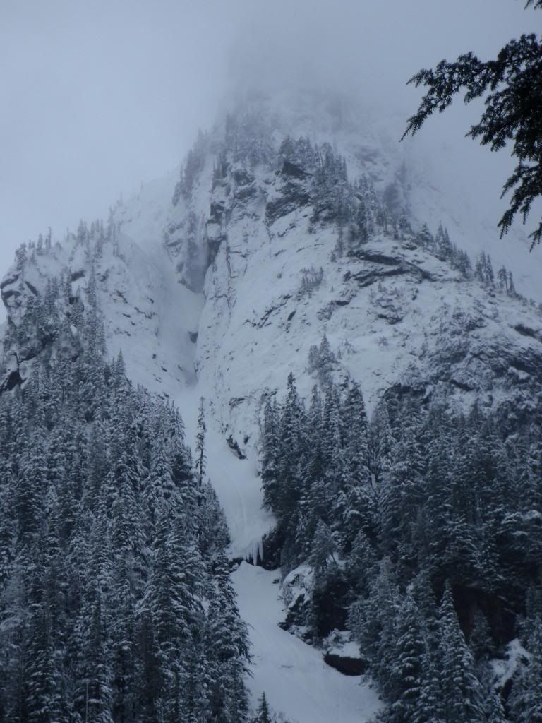
Nice work -- I wouldn't be happy heading up that gully either unless there was a huge pile of debris at the bottom, especially right now. Too bad you lost the vis -- that's one of my favorite views in...
http://www.turns-all-year.com/skiing_snowboarding/trip_reports/index.php?topic=16083.0
Bit drier and snowier in your pictures... huh. ;)
Nice work -- I wouldn't be happy heading up that gully either unless there was a huge pile of debris at the bottom, especially right now. Too bad you lost the vis -- that's one of my favorite views in...
author=Lowell_Skoog link=topic=20162.msg85789#msg85789 date=1300248066]
Perhaps you already looked there, but you can find notes about the avalanche under "Yodelin" at the following link:
http://alpenglow.org/ski-history/subjects/S-info.html#ski-areas-lost
Hmmm, I could swear I checked on alpenglow. I've visit it enough, don't know how I missed it. Thanks Lowell!
Did an 8-mile RT, 2400 vft elevation gain, ski patrol on the South District to High Hut and back; Karhu XCD Guides, vertical STs, TLT5s (with skin-saver forward lean lock block) proved ideal; new snow, conditions were great; advised a couple of senior ladies I passed on the way up of the MTTA policy to stay to the right when snowshoeing and hiking; they thanked me for the info; very friendly; said hello on the way down.
Also saw a young couple descending from High Hut (they spent at l...
Also saw a young couple descending from High Hut (they spent at l...
I could add one more detail I now remember. The rescuers (probably from Stevens Pass) had searched for a long period (24 hours) and really had little hope of finding anyone alive in the destroyed cabin. But somehow (and I don't remember much else about this) they heard voices and that led them to find the girls. The headboard of the bed had provided an air pocket as it fell or collapsed over them.
After the accident, the younger girl, who was perhaps in her early teens, was invit...
After the accident, the younger girl, who was perhaps in her early teens, was invit...
MTTA = Mount Tahoma Trails Association Mount Tahoma Ski Trail System is a non-profit, all-volunteer organization that manages "North America's Largest No Fee Hut to Hut Ski Trail". Right now they have 2 huts and 1 yurt, but it is not really hut to hut skiing; it is more like ski to a hut, then hangout (minutes to days; overnight requires reservations), and ski back to the snow park. One hut burned down but is being rebuilt. I...
Fascinating history. We actually own the closest cabin to the one where the fatalities occurred. We hired Garyback when we bought it to confirm that it was the first safe lot. Still very eerie to walk through the slide alder in the summer and find the ruined cabin with crockery and christmas lights strewn around. I didn't know, or had forgotten, that you knew the family, Gary. Would love to host a TAY party up at our place sometime.
author=jwplotz link=topic=20200.msg85759#msg85759 date=1300225834];D
This is indeed shameless...to those of us stuck in a cubicle :(
Great video.
I have not heard about Boulder Hut, these cabins are multiplying fast!
Perhaps you already looked there, but you can find notes about the avalanche under "Yodelin" at the following link:
http://alpenglow.org/ski-history/subjects/S-info.html#ski-areas-lost
http://alpenglow.org/ski-history/subjects/S-info.html#ski-areas-lost
Gary, thanks for the history. It must have been tough for you and others involved.
First Top it was indeed! The artifacts of satellite reception were checked last evening. :)
This is indeed shameless...to those of us stuck in a cubicle :(
Great vid! Thanks for posting!
Great vid! Thanks for posting!
Didn't try any (didn't look too promising given appearance and what we were skiing on) but I suspect it would have been a 2-6 inches of new, moist snow some with a wind crust on top of a breakable rain crust, probably on top of a complex snow base, potentially unstable; very uneven surface from previous melting. Our lunch spot was about 4600 feet asl (location known as Mountain View), just off the trail; when I stepped off my skis I went thru the top soft snow and then the rain crust...
Say, Andy, you must have been on the north block.. How are the turnable slopes looking up there (above and east of the hut)? Probably kind of wet, but still wondering... haven't been up there this year, although visited (and 'skiied') snobowl earlier. In a good year, I liked the route, 59 > 62 > north along rising ridge > then either mellow glades on east aspect or bowl down to below the hut, and back
Great trip report, video was the stuff of great memories.
The mid-January 1971 avalanche incident took out one cabin and damaged another. Both cabins belonged to Seattle neighbors. If you cross the highway from the Stevens Pass housing facility and take the road to the west, then follow it as the road turns north perhaps a hundred or two hundred yards, you are there. The cabins were only 50' or so west of the road.
There was an ice layer on top of which it snowed 99" in three days, warming as the storm progressed. The avalanche ha...
There was an ice layer on top of which it snowed 99" in three days, warming as the storm progressed. The avalanche ha...
Weaver! Good to see you back in the saddle - or should I say at the loom. That sounds like a good morning workout. Call me next time - I'll donate some yarns.
My very 1st and 2nd days in Washington state in the Spring of 1983 at 20-yrs-old, I solo-toured from Cayuse Pass to Paradise, skiing over ridges, glaciers, etc. I camped on the edge of the lower Ingraham Glacier, traversed to just below Anvil and then skied down to Paradise, before hitching back to my car as Stevens Canyon road opened. I haven't been back to that little region much since. Very cool to see what you're up to Kyle! Get it!
Thanks Chuck
Good thinking, it's good to hear what you were thinking. Not being there it's hard to define the conditions remotely.
Good thinking, it's good to hear what you were thinking. Not being there it's hard to define the conditions remotely.
author=Joedabaker link=topic=20140.msg85597#msg85597 date=1300080486]
Glad you used your instincts and did not go under Chair Peak.
I can appreciate your motivation, but what did you see as safe that drove your motivation further out up the drainage in the snow given forecast and visible signs of high avy danger? What made you feel it was safe enough to proceed, even with the "B" plan goal of Pineapple to Denny Creek? IMO the fog was a blessing...
Yes, now corrected. It was the 13th. This was actually my first time at WP as I usually go to Rainier or northward. It's still a pretty long drive from Elbe on hwy 7, but seems like there is potential for low elevation/low angle touring when the Park shuts down. We couldn't see much...
Wow.
We were up there skiing the trees on the west side of the creek. Saw a large group of Mazamas on skis and four climbers on snowshoes heading for Bullion on the summer trail under east peak. Hope they all got out of there safely before it cut loose.
We were up there skiing the trees on the west side of the creek. Saw a large group of Mazamas on skis and four climbers on snowshoes heading for Bullion on the summer trail under east peak. Hope they all got out of there safely before it cut loose.
Col ,
Do you have the date right ? Could it have been sunday the 13th?
Very curious about area north of white pass as a alternative when longmire gate is not open .
Thanks
Do you have the date right ? Could it have been sunday the 13th?
Very curious about area north of white pass as a alternative when longmire gate is not open .
Thanks
Come and visit anytime, we are not that far. ;)
It looks as though a The NW facing nose of East Peak slabbed overnight.
I was on the opposing side of the valley but from where I stood it looked to be 3 feet deep and hundreds of feet wide.
The summer trail was hit pretty hard by the avi debris.
I was on the opposing side of the valley but from where I stood it looked to be 3 feet deep and hundreds of feet wide.
The summer trail was hit pretty hard by the avi debris.
author=Kyle Miller link=topic=20070.msg85520#msg85520 date=1299977156]
Do you have any lessons learned from the close call?
Just because you ski cut and cornice bomb something it doesn't mean it can't slide.
I noticed that the snow in front of me was moving so I kept up my speed and did a quick traverse right into the trees. I saw that it was coming for me so I slid to the downside of a tree and hugged it for dear life. THe ava...
Great pics, looks like a wonderful place, makes me want to move to Canada.
Glad you got him out in the sun one more time! Poor guy had to ski storm snow for almost the whole trip...
Glad to see some of the photos did work out. Thank you again Scott and Brian. It was the greatest Birthday Lashing I've had. Great way to spend the day. I hope to get back out there soon, perhaps after finals...
awesome Brian!
great day for the ridge when you can't see much. Just watch out for giant man swallowing holes down lower.
where at Zack? Where you transitioning in the north side talus field?
Turns out there where a lot of people I knew up there, and a whole slough of new split boarders.
great day for the ridge when you can't see much. Just watch out for giant man swallowing holes down lower.
where at Zack? Where you transitioning in the north side talus field?
Turns out there where a lot of people I knew up there, and a whole slough of new split boarders.
Glad you used your instincts and did not go under Chair Peak.
I can appreciate your motivation, but what did you see as safe that drove your motivation further out up the drainage in the snow given forecast and visible signs of high avy danger? What made you feel it was safe enough to proceed, even with the "B" plan goal of Pineapple to Denny Creek? IMO the fog was a blessing in disguise to turn you around even if the trip was maybe kinda running the gamut. Given the conditions, i...
I can appreciate your motivation, but what did you see as safe that drove your motivation further out up the drainage in the snow given forecast and visible signs of high avy danger? What made you feel it was safe enough to proceed, even with the "B" plan goal of Pineapple to Denny Creek? IMO the fog was a blessing in disguise to turn you around even if the trip was maybe kinda running the gamut. Given the conditions, i...
I thought I saw Scott back there. Amazing the difference between North and South slopes.
You must be British with that wording! Not heard that for a while.
Hi Irena, Scott, Justin - great to see you guys up there - fun times indeed!!
Oyvind (Joe and Kevin) :)
Oyvind (Joe and Kevin) :)
Do you have any lessons learned from the close call?
Just because you ski cut and cornice bomb something it doesn't mean it can't slide.
I noticed that the snow in front of me was moving so I kept up my speed and did a quick traverse right into the trees. I saw that it was coming for me so I slid to the downside of a tree and hugged it for dear life. THe avalanche came within 5 feet of me.
As for the traverse.
There are many ways that it could be...
Thanks. I should have realized that if anyone, Skoog would know about and have done it, and written it up in detail as well. The historical accounts are eye-openers. I never realized how much ski history preceded the development of Crystal in that area.
Also, it was affirming to read about Lowell's pleasure in traversing hard snow, as I too have enjoyed those type of days: moving swiftly across great distances in the alpine with minimal elevation loss.
It looks l...
Also, it was affirming to read about Lowell's pleasure in traversing hard snow, as I too have enjoyed those type of days: moving swiftly across great distances in the alpine with minimal elevation loss.
It looks l...
Skoog's site has some good info, though he went Pardise to Cayuse (including Little T) and then Crystal to Cayuse some time later. Read for yourself:
http://www.alpenglow.org/skiing/crystal-1991/index.html
http://www.alpenglow.org/skiing/cayuse-2001/index.html
Cheers
http://www.alpenglow.org/skiing/crystal-1991/index.html
http://www.alpenglow.org/skiing/cayuse-2001/index.html
Cheers