TR Replies
Wow, way to nail a bunch of great lines in one go. Inspiring.
Killer trip in one of my favorite areas.
Where is the snowline on the road?
Where is the snowline on the road?
Great! I love it when the mid fork gets some attention. Believe it or not, Bessemer even appears in a handful of guide books for skiing (usually old ones). It was probably more popular with the skinny skis. If that only got you interested in the peculiarities of this terrain then look into the green ridge lake trail or Dingford. Plenty of miserable approaches for marginal gains but also some unique experiences like skiing thru hemlock groves and some fun cols hide in there.
... and what are those tracks (prints) in the summit photo? Look big.
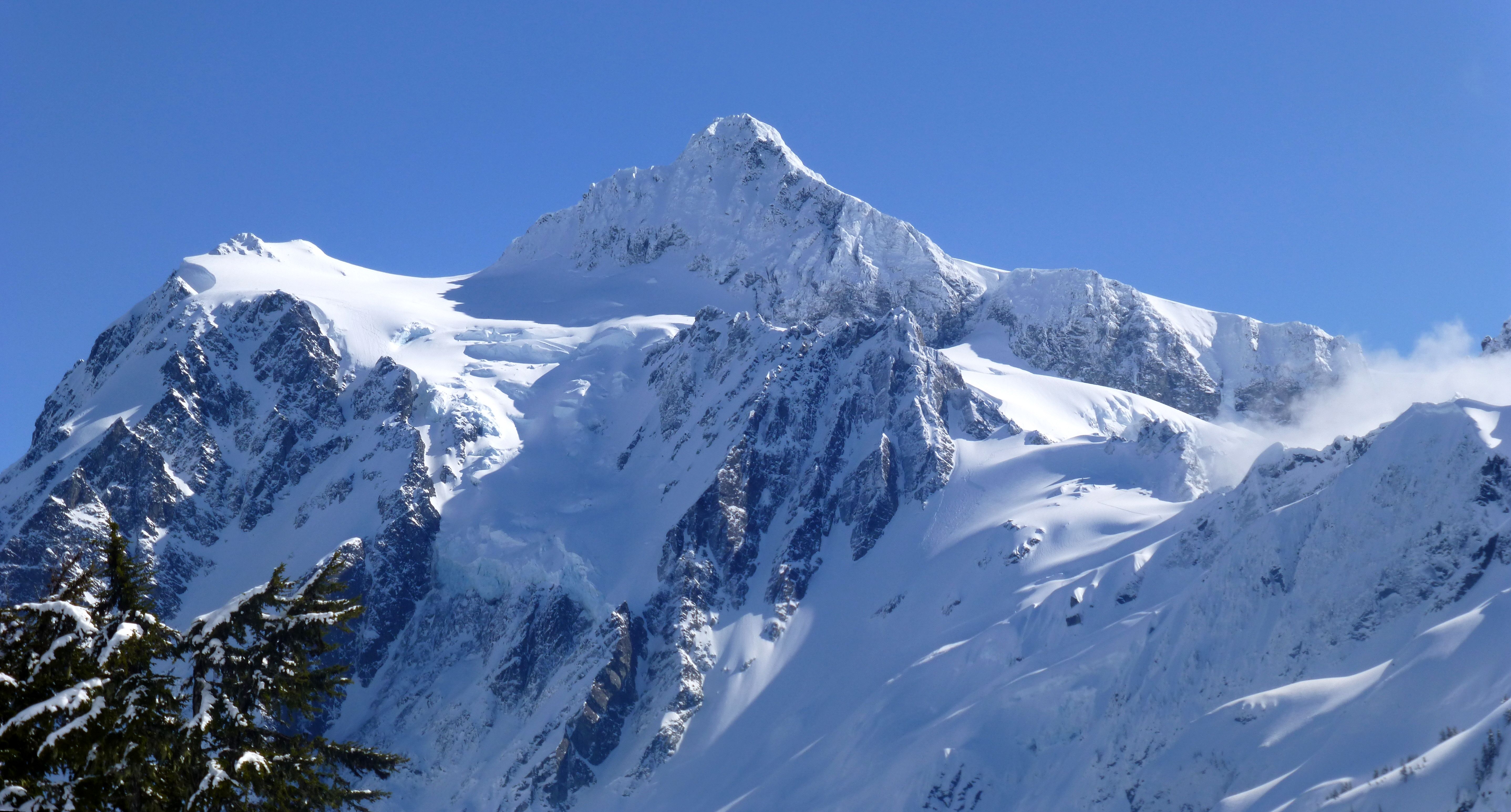
What a trip! Nice work -- that picture of Stuart's north side has me drooling for warm summer granite...
What?? No invite? Great report bro and well written. My Santa Cruz would have loved it!
Long Live the Common Man!
Sweet,
Now I know who to call for partnering up on a sufferfest!
Well done
Sweet,
Now I know who to call for partnering up on a sufferfest!
Well done
What next? Mt. Si? I don't think it's been skied... ;)
nice one! good mix of self propelled motion. could prob skip the car altogether and just do this straight out of North Bend...
nice one! good mix of self propelled motion. could prob skip the car altogether and just do this straight out of North Bend...
Megan looks like a ripper--great form!
Sunday's looking good again...
Sunday's looking good again...
Awesome -- nice work! The Middle Fork always delivers, as someone said to me. Sometimes it just delivers suffering.
Well documented..did not even need pictures just let the imagination flow!
Thanks for sharing an unknown area...at least to me.
Thanks for sharing an unknown area...at least to me.
Looks like an sweet trip! Definitely putting that pillow field on my hit list.
wow, beautiful! nice work fellas!
Yep! I just noticed that last night while comparing a couple of different photos.. awesome day you had for sure!
and thanks for posting your stoke.. that's what I wanted to see ;D
Here's a full size pano of that pic for ya
and here's one of you just out of the traver...
and thanks for posting your stoke.. that's what I wanted to see ;D
Here's a full size pano of that pic for ya
and here's one of you just out of the traver...
Ive skied there a little ,mostly out of Spruces. I started out with a Wasacth tour book and a wonderful map that was, photo one side topo the other with routes laid out. It's a huge area .
Being a ski tourist I always picked off the low hanging fruit as the avy situation is touchier there.
There might be a updated field map still. Mine is called simply "Wasatch touring map 1"
The web site you linked to is much more detailed.
Being a ski tourist I always picked off the low hanging fruit as the avy situation is touchier there.
There might be a updated field map still. Mine is called simply "Wasatch touring map 1"
The web site you linked to is much more detailed.
Thanks for the report - I'm looking forward to heading down there in a few weeks. Looks like you guys are about to get a recharge!
http://opensnow.com/dailysnow/tahoe
http://opensnow.com/dailysnow/tahoe
That site is awesome, but at first I was overwhelmed. It's got so many areas called out that it's tough to get a general sense of where to go. It's like having 40 named runs in commonwealth basin... kinda crazy. I feel like I'll never get through Rainier's book, so trying to make a to-ski list from that website is daunting!
So who's doing that for baker bc? I want a pinpoint for each blueberry chute!
So who's doing that for baker bc? I want a pinpoint for each blueberry chute!
Great TR, nice to know what was happening in other areas while we found all the drip chunder at Snoq and dust on crust at Blewett on those same days. Way to snoop it out!
Hey, these are awesome!
I think you can see Eric and I in the NWC in the first shot. I'm directly below the traverse cliff, and he's a couple hundred feet down on the skiers right side of the snowfield. The shadows seem to match up with my pictures.
our perspective
Pretty ideal conditions on Saturday, too bad it couldn't stay that way... Anyone get a final count of how many people skied it? I counted at leas...
all that talk of food only to end at Micky D's. cool tr.
author=hedonaut link=topic=27909.msg117418#msg117418 date=1363291388]
yeah Phil, I think that's the way to go if sun-warmed slopes are not a concern. For us it was partly that, and partly my lack of certainty--what looks good on paper (map) doesn't always work...so we went with the way i knew, albeit a bit spooky.
I actually don't know for sure that it goes, but it looks good in photos from the north side, and the...
Wow! Really awesome, and inspiring...thank you for sharing!
Nice, Trees. Thanks!
1166 Google Earth pinpoints within a small defined area ~ No being catish 'bout where you spent the day, eh..
HillsHaveEyes should like this, too.
1166 Google Earth pinpoints within a small defined area ~ No being catish 'bout where you spent the day, eh..
HillsHaveEyes should like this, too.
Big thanks for that cool wasatch website. I owe you a beer
July 2, 2011, is when that shot was taken--and the 2010-11 season had good snow coverage.
I imagine when the sun goes high enough to hit the face with temps. to match it melts out quite fast. I'm sure we came across the previous reports and figured it'd still be good. 2008 must have been a banner year! Or colder/cloudier...
We looked down Marble too and it had quite the stream tumbling beneath the remnant snow. Doable maybe but not worth p...
The best area in the world in my opinion!
How were the roads??
How were the roads??
author=hedonaut link=topic=27909.msg117418#msg117418 date=1363291388]
As I recall (caveat: poor memory), Sky, Phil and crew bagged it as late as June.
Great pics Hedo. Yeah, I'd like to know when Cumulus took that shot too. Sky, Marq and I skied it on July 12 of 2008. In really good conditions no less.
Thanks for the report Kyle. It was an awesome trip. I can't wait to edit through all the images. That's an adventure of its own.
so scenic, beautifully captured by legs, lungs and camera. well done fellas.
completely agree re: avoiding road skinning if possible.
great time at the tractor! nwac parties rock.
completely agree re: avoiding road skinning if possible.
great time at the tractor! nwac parties rock.
yeah Phil, I think that's the way to go if sun-warmed slopes are not a concern. For us it was partly that, and partly my lack of certainty--what looks good on paper (map) doesn't always work...so we went with the way i knew, albeit a bit spooky.
Thanks all for stoke-sharing...Kyle, you would definitely enjoy that area. You and Jason should enchain it with the Isolation or some other maniacal traverse ;)...
Wow cumulus, that looks rugged...what time of year did y...
Thanks all for stoke-sharing...Kyle, you would definitely enjoy that area. You and Jason should enchain it with the Isolation or some other maniacal traverse ;)...
Wow cumulus, that looks rugged...what time of year did y...
looks grand! was wondering where you may be given last Saturday's window
from a couple yrs ago... we got there a little too late

beautiful area!
from a couple yrs ago... we got there a little too late
beautiful area!
Awesome! Glad to see some steeps starting to go down.
Thanks for the report! Very inspirational to say the least!
Awesome work! One day I will ride that line.
author=glenn_b link=topic=27908.msg117389#msg117389 date=1363236629]
Nice pic of the Chiwaukums. Some good lines to be had there for those who don't mind a bit of an approach.
"a bit" of an understatement!
Awesome.
Regarding your approach, can't you cross the 6700ft notch to west of the Triad? From there it's easy to scoot around to the top of Kumquat. (Maybe you were trying to stay off of south slopes?).
Regarding your approach, can't you cross the 6700ft notch to west of the Triad? From there it's easy to scoot around to the top of Kumquat. (Maybe you were trying to stay off of south slopes?).
Fantastic -- that's some exposure... wonga. Thanks for posting it!
WOW ! Great trip and photos. ;)