TR Replies
Here's a photo of the west face of Jefferson, taken on May 1st from the Milk Creek Junction. A lot of good ski terrain in there, but as Tim mentioned, it's kind of a slog to get in there from the Pameila TH, and that coupled with the steep trees on the approach, at least to the SW side, make for a long day. I didn't get nearly as high as thought I would, after running into frozen conditions in a steep drainage.
author=Charlie Hagedorn link=topic=28507.msg119912#msg119912 date=1368379015]expect moats below anything steep that's not 'piste'.
For sure on that one. Cracks are in abundance on anything steep and off the beaten path. Our run out Hummocks required two raps off big trees using a short section of rope. Good times for sure!
Incredible day. The FF is in perfect shape right now with little crevasse danger (at least on the upper mountain) allowing for a direct route. The Wilson glacier approach had quite a few snow bridges that were getting soft and a little questionable. Comfortable summit temps made for a leasurly summit stay.
Do you have any pics of the current conditions?
45 min road walk. Nice conditions, but it should be mentioned that there is pretty bad pollen. You might want to bring some Goo Gone or something to clean it off.
Thanks for the report, I was just wondering what the status of the highway was, I am hoping to ski it this spring, sounds like I better get moving. Hopefully it will cool down a little and save some corn!
Hi,
We were the couple that you saw up there. We turned around just before you guys - you were right about the soft snow!
We initially tried driving up towards Rye Spring with an idea of skiing the SW face, but found it blocked within a mile of the highway. We then headed up the road towards Fourmile lake. It was plowed for 3.5 miles up from the highway (to within 2.5 miles of Fourmile lake), so we camped there and set off from that point. We ended up having some naviga...
We made it thanks to a 3-foot wide ribbon of snow a few hundred yards in ;D It's probably gone by now. About 500 feet up, coverage is still good though.
Great trip report and the photos of the dog rescue were wonderful. ;)
My last trip to South Sister required Jill and I to hike the trail to the flat and start skiing. Nice to see that you skied back down.
My last trip to South Sister required Jill and I to hike the trail to the flat and start skiing. Nice to see that you skied back down.
Awesome trip guys! Todd, you work with my sister-in-law, Jenni Schmidt. She introduced us a few weeks ago. Your blog is quite inspiring! I'd love to get out there with you some time. Until then, keep up the good work! -Robby
author=Oyvind_Henningsen link=topic=28515.msg119942#msg119942 date=1368414210]
and skied to within 52 yards of the trailhead ;-)
It's going away fast this year. And the warm downpour we're getting right now won't help.
Nice ! Went up on Thursday, a few less folks ;-) and skied to within 52 yards of the trailhead ;-)
That is one massive conga line.
That is one massive conga line.
author=Jim Oker link=topic=28515.msg119935#msg119935 date=1368410028]
So what is in the hoard that the ranger wanted to steer you away from, and were the hordes getting into it? [insert clown emoticon here]
Cornices. But in the picture seems the hoards were staying back.
There was an official of some type stationed at 4800' checking permits when I passed through. I wonder how much of the $15 per person ($7 is a 'transaction fee') is spent on enforcement.
Hopefully none of the injuries was a big deal. I saw a dog once that was putting out quite a bit of blood from an abrasion cut from spring snow, and it turned out to be a pretty small thing, mostly a sign that the dog should have either had booties or just not been out there, but not too bad (and then again, I've heard of dogs having tendons sliced by ski edges :().
author=Kuroyama link=topic=28515.msg119932#msg119932 date=1368407137]
At the...
I was one of the 683. My first time up and it was awesome! The crowds didn't both me. They did make a nice easy boot track to follow.
We did see some glide cracks but they were easily avoided. The other hazard were glissaders. I am not used to looking up hill to make sure I won't get hit but an oncoming glissader when traversing.
At the advice of the very nice climbing ranger we went lookers right of the hoards and got a spot on the rim to ourselves.
author=CascadeClimber link=topic=28515.msg119926#msg119926 date=1368398587]
The upside is that there were lots of pretty women-folk in skirts :)
i was wondering if the Mothers Day ski party on St.Helens was going to be celebrated a day early given the forecast.
The upside is that there were lots of pretty women-folk in skirts :)
Wow!
We were there on Thursday, and took a route similar to Lowell's from last week. Only saw one other person.
We were there on Thursday, and took a route similar to Lowell's from last week. Only saw one other person.
That run to annette seems to melt out fast. Thanks for the cc update. Is all the snow melted out on sliver fir and the nordic trails? I wanna carry a dura-flame log over those again.
Holy ant trail batman! Thanks for helping me appreciate having made my first trip up there back in March before it gets quite so busy! Of course if you're climbing on skis you can always chart a course away from the crowd in terrain like that.
That is a neat photo. Thanks for the conditions update!
author=silaswild link=topic=28507.msg119904#msg119904 date=1368336928]
Dusk patrol provided some of the best corn I've skied this month! The slopes are smoother every day, but the heat of the past week has opened surprising cracks here and there.
Seconded - expect moats below anything steep that's not 'piste'. Can still ski within 6-10' of the patio, creek coverage down low is more than sufficient. Lower...
author=shred link=topic=28513.msg119909#msg119909 date=1368374099">
Did you see DOD and Jessica?
Tbill! Indeed we saw you on the carry section, and hoped you enjoyed your day too! We agree with your excellent logistic report on road and pollen. It was the Silver Peak Pollen Party! made the road downhill a-pole-kick-glide-pole-pole-sticky...
Thanks for the report T. Did you see DOD and Jessica? They said they saw a knuckle dragger running around up there. :)
Thanks for road update !
Bummer on the pollen . Rain might make it go away?
Bummer on the pollen . Rain might make it go away?
Was a blast last night with everyone and finally got to put some faces to folks on TAY.
Dusk patrol provided some of the best corn I've skied this month! The slopes are smoother every day, but the heat of the past week has opened surprising cracks here and there. https://vimeo.com/66031590
I wondered where you were today, Robie. I looked all over Paradise for you guys...
Ditto!
Using Silas's recommendation instead of driving to Paradise.
Dave and I did two laps on lower half and thought the skiing was excellent for time and place . One note- I skied very close to some of the big trees and picked up some pollen on our second run. Not enough to be notable while skiing but would have caused trouble on the next up. Went to beer at noon.
Getting into the couloir from the bottom isn't obvious. We missed it in 2009, coming from Beverly Creek. Might be easier to see from Longs.
http://www.turns-all-year.com/skiing_snowboarding/trip_reports/index.php?topic=13080.0
http://www.turns-all-year.com/skiing_snowboarding/trip_reports/index.php?topic=13080.0
Thanks!! At least I know I was eyeing the right thing now. Looking at my pictures, the bottom is definitely much more melted out now, but I'm sure the line is still skiable just fine. I should have gone for it. Oh well, I guess if I wasn't feeling it, no sense in second guessing. :)
author=JoshK link=topic=28467.msg119873#msg119873 date=1368202617]
but I saw what looked like at least one mandatory downclimb around a waterfall.
As Brian's pic shows, you gotta bail out of there before the waterfall.
I was wearing liner socks. My feet held up surprisingly well until the bushwack/trail with sweat-saturated socks.
author=JoshK link=topic=28467.msg119873#msg119873 date=1368202617]You guys don't happen to one of your pictures with your route drawn in, do you? I'm pretty sure I was looking at the right couloir, but it's been years since I've been on that side of the mountain, so it would be nice to confirm.
Here ya go!

Liner socks will keep that from getting so bad.
Anyone lose an Iphone at the base of chair 2 around this time? Friend found one the next day 09May2013. PM and I'll send you contact info.
B)
B)
So I went up to give Ulrich's a go yesterday. It's pretty amazing how much melt can occur in 5 days on south slopes in that part of the range! It probably can still be skied, for the most part, but I saw what looked like at least one mandatory downclimb around a waterfall. Being solo, the view from Long's pass was depressing enough to drain my enthusiasm. :'( I thought about Cascadian, which looked better up high but required a minimum of hundreds of feet of walking on...
all snow is good snow (and all skis are rock skis) but it was 55 F at P at 5 a.m. today and I think I'll skip skiing and go biking :-)
No pollen here. Just a lot of dirt on the skis. We're you the skier I talked to on the ridge?
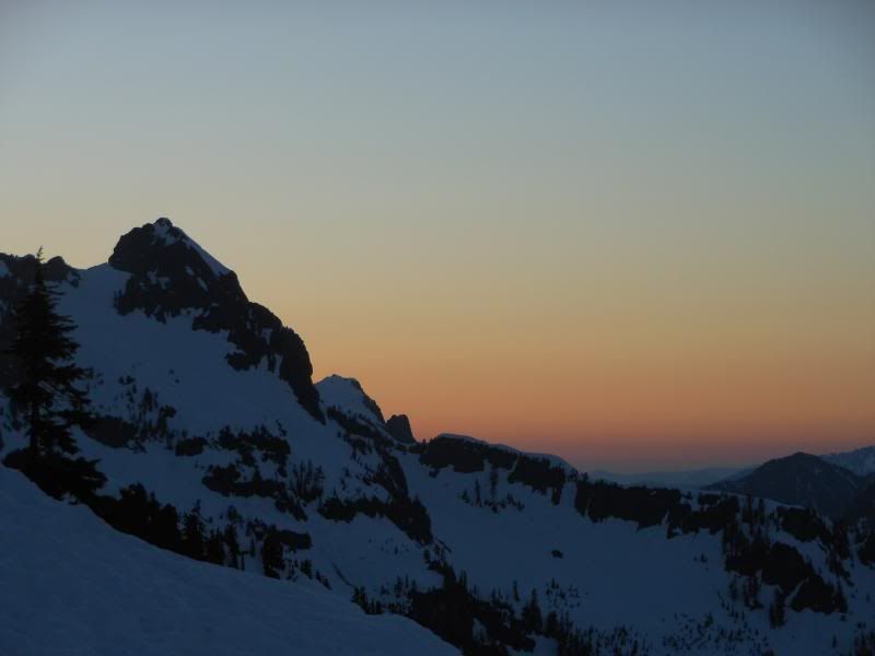
What was really cool was seeing where the sun set last night. In a totally different spot than I'd seen it before.
What was really cool was seeing where the sun set last night. In a totally different spot than I'd seen it before.

read the full version of your TR.... great write up! congrats on the traverse
author=wolfs link=topic=28496.msg119857#msg119857 date=1368131702]
Today's dusk tour experiment: packed some summit mead rather than traditional summit beer. Meh, like beer better, but for those that care you can get decent quality mead in a can now (Blue Dog, Oregon).
Stick to summit beer, that's what we did! Good to see you again Wolfs! Try out the new Fremont Organic Pale Ale they made for Seattle Beer Week that sta...
Love the pics! A master behind the lens!
Not any serious pollen issues, but did have some issues with skins picking up silver grease from either the cats or the from chair.

We had a snow cave that covered us to about mid-thigh, and a 2-3' deep trench extending beyond that. We guyed our poncho/tarp to trekking pole halves, and we buried the boundary under snow blocks. A vertical trekking pole pushing the tarp up near the entrance made it somewhat taut, and a backpack plus a pile of boots closed off the entrance.
Inside, I had the bottom of my sleeping bag stuffed in my pack - very effective at insulation and protection from snow above an...
Inside, I had the bottom of my sleeping bag stuffed in my pack - very effective at insulation and protection from snow above an...