TR Replies
Yeah, Kam! Way to score! Your stove malfunction, reminds of a time gone by, of a little game called stove soccer. Three Fingers lookout is a bad place to have a stove flair up... word is, there's a...maybe useable Whisperlite, at the base of the East face. :)
Hey Garrett, the conditions on the face are pretty good right now. You will be able to pass the schrund climbers left. It's actually easily visible from the road, so you can't miss it, right at the bottom of the face where the slope angle goes from ~30 to ~40+
sounds like fun!
sadly i've been consumed by trying to get my van running with its new engine and haven't been back out since i ran into you up on the fryingpan. considering that i was introduced to the sport that day i will enlighten the uninitiated--"bottleering" is like mountaineering except that instead of technical climbing gear you have bottles of home brewed cider, and instead of risking your life on steep, exposed faces you are sitting in the sun and...
sadly i've been consumed by trying to get my van running with its new engine and haven't been back out since i ran into you up on the fryingpan. considering that i was introduced to the sport that day i will enlighten the uninitiated--"bottleering" is like mountaineering except that instead of technical climbing gear you have bottles of home brewed cider, and instead of risking your life on steep, exposed faces you are sitting in the sun and...
author=runningclouds link=topic=34310.msg141617#msg141617 date=1432760794]good question.
Thanks for the TR, it would be nice to see a pic of Emmons. What is bottleering?
You summed of the season very well with the gear reference.
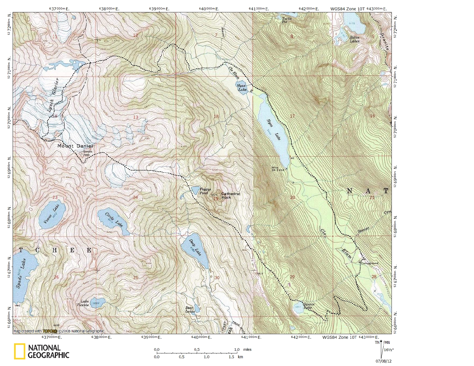
Thanks for the inspiring post, Lowell. That is such a beautiful area to ski that it makes one forget all the dirt-walking involved in getting there. Were you able to skin much from Squaw Lake to Cathedral Pass? Below is a nice pano of me and James H. when we were there 3 years ago. It appears that now TWO people with last-name Freeman have skied Lynch. Maybe there are more. I've been thinking that a great trip would be to camp for a few nights at Lynch Dr...
Thanks for the TR Kam! I've been looking at that face all season, wondering when it would be safely consolidated enough to ski. Nice job tackling that one solo!
When you talk about passing the bergschrund "on the left" - I assume this is climber's left? At about what elevation was this?
Glad you didn't blow yourself up while making dinner!
When you talk about passing the bergschrund "on the left" - I assume this is climber's left? At about what elevation was this?
Glad you didn't blow yourself up while making dinner!
"Having a pair of skis with Dynafits is like having a chair lift in your pocket."
That is a true fact!
That is a true fact!
Thanks for the TR, it would be nice to see a pic of Emmons. What is bottleering?
Great TR! Thanks for sharing.
Here is a 13 MB low-quality cell phone panorama taken from Fortune Pk. in the Teanaway at 11:06 on May 24th showing the clouds spilling through the gaps in the Cascade crest.
Nice. Looked pretty good over your way from Fortune/Ingalls this weekend.
author=ps44 link=topic=34305.msg141581#msg141581 date=1432597919">I would be interested in more details on the "cross-country route out of the Cle Elum River valley" approach - would you mind to elaborate?Dunno how Lowell went, but there are a couple ways, e.g., our descent route...
I have been using mountain-forecast.com. It shows forecasts for different elevations which I find helpful for a quick go to for wind and was actually useful for cloud level too a couple weekends ago. It showed sun for Rainier at 8k and above when I went up to the prow a few weekends ago. Same for this weekend, but I didn't get a chance to get out this weekend to see if it was true. It has been pretty accurate when I've used it! http://www.mountain-forecast.com/peaks/Mount-Rainier
Great TR, route, and photos :)! We were adventuring in the clouds nearby.
Just wanted to add one number (we didn't ski, but the number's been hard to find); skiable snowline on the SE side of Chickamin was ~5200' Sunday/Monday.
Just wanted to add one number (we didn't ski, but the number's been hard to find); skiable snowline on the SE side of Chickamin was ~5200' Sunday/Monday.
I started a new thread that describes what I look for to predict cloud top elevation:
http://www.turns-all-year.com/skiing_snowboarding/trip_reports/index.php?topic=34309.0
http://www.turns-all-year.com/skiing_snowboarding/trip_reports/index.php?topic=34309.0
search for "cloud water"
http://www.atmos.washington.edu/mm5rt/rt/gfsinit.d3.html
then, pick the elevation you're looking for.
or, just do the "column integrated" option and you'll see the full picture.
note: this forecasting tool is a crapshoot too. i look at it and then start grabbing the grains of salt...
http://www.atmos.washington.edu/mm5rt/rt/gfsinit.d3.html
then, pick the elevation you're looking for.
or, just do the "column integrated" option and you'll see the full picture.
note: this forecasting tool is a crapshoot too. i look at it and then start grabbing the grains of salt...
for sure! would be great if they could try to nail down cloud deck elevation!? I've never been able to find such info. please post if someone knows of any.
I had a similar experience last week, forecast was for cloud-rain, but Paradise was well above that.
I had a similar experience last week, forecast was for cloud-rain, but Paradise was well above that.
We also went up to Green Lakes for Memorial Day weekend. Found some nice bare ground to camp on. Tried getting to the east side of South Sister the first evening but didn't want to remove my boots to cross the creek (lazy I know) so we headed up Broken Top for an evening mashed potato harvest. The next day we continued on past Green Lakes and off trailed it to the saddle between South Sister and Broken Top. Was eyeing two sets of tracks and went and added a third set of tracks and followed...
author=EricW link=topic=34260.msg141544#msg141544 date=1432240460]
Which route did you take from the Devils lake campground? Moraine lake or Green Lake? I am trying to figure out where the snow line is on the Moraine lake route. How far will I be carrying my skis before I can put them to use?
Thanks!
We went into Green Lakes over Memorial day weekend. Patchy snow starts around 6,000 feet, continuous snow is now found a...
That black and white is my favorite. Lowell you take great pictures.
Did you drive all the way to the trail head?
Did you drive all the way to the trail head?
...go!
Agree with the others, nice photography. Well-played, timed trip. Also curious to see your route.
Agree with the others, nice photography. Well-played, timed trip. Also curious to see your route.
Wow that is a bit more crazy than the Frying Pan...LOL. I would be worried the dang stuff would let go in one big massive slide in those dang chutes. Amazing pictures. Happy you made it back for the fun ski a couple weeks ago despite it being just plain old wonderful corn!
Very good timing of a window in that pesky weather we have been having lately. The clouds must have been fascinating to watch.
I would be interested in more details on the "cross-country route out of the Cle Elum River valley" approach - would you mind to elaborate? How was snow?
I would be interested in more details on the "cross-country route out of the Cle Elum River valley" approach - would you mind to elaborate? How was snow?
Nice work Lowell! Thanks for posting. There's high likelihood I'll be there or on baker or both this coming long weekend for myself.
Way to channel your rehab energy Ben! That's one heckava trip
author=shred link=topic=34305.msg141576#msg141576 date=1432585662]
Some really nice set of shots there, Lowell!
Way to sneak in a neat looking trip, with gloomy, doomy forecasting keeping most of us sidelined into domestic affairs. Bravo!
Thanks Jeff. We saw your group's entry in the Mt Daniel summit register on May 20. I was surprised that there had been no other entries yet this year.
Inspirational! Don't know if you don't...
Some really nice set of shots there, Lowell!
Way to sneak in a neat looking trip, with gloomy, doomy forecasting keeping most of us sidelined into domestic affairs. Bravo!
Way to sneak in a neat looking trip, with gloomy, doomy forecasting keeping most of us sidelined into domestic affairs. Bravo!
author=EricW link=topic=34260.msg141544#msg141544 date=1432240460]
Which route did you take from the Devils lake campground? Moraine lake or Green Lake? I am trying to figure out where the snow line is on the Moraine lake route. How far will I be carrying my skis before I can put them to use?
Thanks!
We went the usual summer trail which heads towards moraine lake, though we didn't actually take the side trail over...
Awesome write up as usual Ben! I can't wait to see the rest...and to get back to AK!!!
Thanks for for the full meal deal tr...monumental for sure!!!!!!!!!!!
Ben, Kam, Roger, and Tara, my inspiration! Thanks for sharing.
author=Kyle Miller link=topic=34290.msg141484#msg141484 date=1431951185">

sick!
thanks for posting; i've been wanting to see more photos from your travels this spring.
throughout our trip, we utilized many sources of information to familiarize ourselves with this new and imposing environment. we benefited from a ski guidebook, extensive cell phone topo maps, and saign's winter of research. but our most valuable resource of all was the sage advice of an experienced alaskan snowboarder named jaime. posting under the moniker "snowsavage" jaime has been regaling the internet for years with well written and superbly photographed tales of adventure...
optimism and excitement were running high as we entered the second half of our trip. the forecast looked great for the rest of the week, but as we were learning, the chugach weather predictions are a bit more of a gamble than the precision modeling that we are used to in washington.
this was the exact opposite of what we expected to see driving up to the pass from camp. in fact, we decided to write off the day and go explore by car to see if we could find some interesting...
this was the exact opposite of what we expected to see driving up to the pass from camp. in fact, we decided to write off the day and go explore by car to see if we could find some interesting...
that night we headed further north, down the inland side of the pass to the rendezvous heli ski lodge. with bar that offers $5 showers, it seemed like an ideal place to wait out a storm. the lot across the street seemed like a perfect dirtbag camp spot, and i was slowly getting used to the fact that it's generally acceptable to camp on the side of the highway at thompson pass. i dubbed this location "campsite 12-3".
![]()
We skied from the sub-peak above Gallagher Head lake first then cruised around to the true summit.
Not sure, just skiing the best of what we could see ::)
Awesome vid! Hawkins is a go-to spot for us in winter, but I can't seem to figure out where you were skiing. Were you dropping in on the far skier's right (west) of the N side, above the Gallagher col?
Which route did you take from the Devils lake campground? Moraine lake or Green Lake? I am trying to figure out where the snow line is on the Moraine lake route. How far will I be carrying my skis before I can put them to use?
Thanks!
Thanks!
Yes, the road is clear of snow and bikable to Obstruction Point. However, the gate is close so there is no car access past Waterhole as of Thursday May 21. I could open any time though so I would call the park prior to making the drive over.
DH
DH
The twofer ski report was great, just sorry the sking was not great as well. Thanks for the post.
author=ps44 link=topic=34287.msg141519#msg141519 date=1432057468]
The solo skier was me - nice to meet you all.
I should have asked! Great pics, and I agree - some diurnal freezing & thawing are in order.
Hey! Nice write up Jamie! It truly was the experience of a life time to experience the Birthday Tour in all it's naturalness.
Good times for sure!
Good times for sure!
The solo skier was me - nice to meet you all. I was hoping for a corn situation higher on the Fryingpan glacier but gave up at about 8200'. Even there the snow was amazingly saturated with water. Water skiing comes to mind. From what I could see, Fryingpan Glacier looks really nice; smooth and clean. It should be in prime after a few cold nights and warm days.
Meany Crest
Meany Crest