TR Replies
The title in BOLD really makes your TR stand out.
author=nordique link=topic=12359.msg51720#msg51720 date=1235089646]
The one time I was avalanched was also in a fog situation, in the Canadian Rockies, above Bow Summit. As we ascended, conditions were fine, but then the fog developed incredibly fast. We were far above Peyto Lake and decided to descend back to the car, so headed south and east--and skied off a cornice in the fog, landing on a slope that then avalanched, carrying the two of us down about f...
author=telemack link=topic=12374.msg51736#msg51736 date=1235105171">
We tele-folks bust the variable crust one leg at a time, ya know? Sit back a bit and ease the front ski into the choss.
I probably would've biffed like the other geezers, but I would have been in good company.
Jeanette should had more consideration for her backcountry brothers and sisters and warned you all of the extreme hazard we encountered, and informed...
Thought I was following some dog tracks up the trail on Sunday. Looks like some good powder to be had, we went up Lundin and had some good turns as well.
We tele-folks bust the variable crust one leg at a time, ya know? Sit back a bit and ease the front ski into the choss.
I probably would've biffed like the other geezers, but I would have been in good company.
I probably would've biffed like the other geezers, but I would have been in good company.
Good show Silas! Turns don't get much prettier than these.
crap! that's what i missed today.
nice photos.
nice photos.
A few more photos:
This is what the northeast side looks like, by the way...
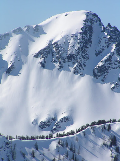
Stuart

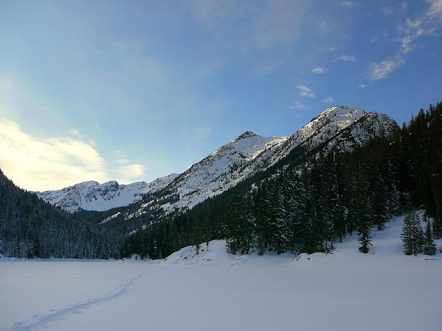
8 Mile from 8 mile lake
Not all of us make it...
This is what the northeast side looks like, by the way...
Stuart
8 Mile from 8 mile lake
Not all of us make it...
The one time I was avalanched was also in a fog situation, in the Canadian Rockies, above Bow Summit. As we ascended, conditions were fine, but then the fog developed incredibly fast. We were far above Peyto Lake and decided to descend back to the car, so headed south and east--and skied off a cornice in the fog, landing on a slope that then avalanched, carrying the two of us down about fifty feet--below the fog line, to the top of a cliff that fell a very long way down to Pe...
author=JibberD link=topic=12374.msg51702#msg51702 date=1235066826]
So do you have any idea what this "snare line" was?
Yep it was a buried "semi" breakable crust layer.
What a great stretch of weather and skiing! We spent the last five days up there too and did the Young's traverse the day after you on Tuesday, 2/17. The other highlight was the Little Sifton traverse on Sunday with some beautiful cloud watching. Saturday we toured below Sir Donald, Monday above Balu Pass and yesterday a short run in the NRC gullies before heading out. Our third trip to Rogers Pass and they just keep getting better.
So do you have any idea what this "snare line" was?
Sounds like a classic day for you guys, although I don't think I've ever seen the Mad_Dog yardsale. ronj, yardsale, yes, I've seen that once or twice. An arm's length from the fury is recommended when it happens... ;)
Sounds like a classic day for you guys, although I don't think I've ever seen the Mad_Dog yardsale. ronj, yardsale, yes, I've seen that once or twice. An arm's length from the fury is recommended when it happens... ;)
You're welcome, Ryan, Skiguitarist.
I found that situation interesting and thought immediately at the time, "Whoa, I'm in avalanche terrain!" Then the reasoning part came into play and that part told me that in this snowpack, the situation was not particularly threatening. I merely descended to lower angled terrain. But it sure shows to go ya how easy it would be to get in trouble in flat light.
I recall a couple (few) years ago a guided party in Canada...
Wow! The range behind you in the summit ridge photo is stunning. I hope I can get up there soon.
author=skierguitarist link=topic=12363.msg51663#msg51663 date=1235009607]
What is the name of that place in Revelstoke?
most of the motels in Revelstoke had lodging/ticket combo packages...the Days Inn had some rooms that slept 6 and that was the best deal we found.
"shralp the gnar-gnar bro bra!"
highly amusing vignettes!
highly amusing vignettes!
Try this link:
http://picasaweb.google.com/GreggCronn/TheEggBrothersGoSkiingOnPresidentsDay#5303971734968888962
http://picasaweb.google.com/GreggCronn/TheEggBrothersGoSkiingOnPresidentsDay#5303971734968888962
...finally got to dealing with my pics.
Thanks to REI for a head injury (don't buy a Novara bike) I can't get to
things sometimes.
The first pic I took the following day taking in some blissful pow runs I didn't get my fix of the day before :)
Anyway Oyvind and I climbed that second diagonal line on the lower curtis. It runs parallel to the first one.&n...
Have any pics? Pics are good..even face shots.......
Nice turns!!!!! What is the name of that place in Revelstoke?
Appreciate your thoughts and words.....THANKS SO MUCH!
Pretty sweet Pete- looks beautiful! I think I'll have to make it up there one of these days.
I didn't quite finish my thoughts on this.
Even though we were never more than about 30-40 yards off route, we still ended up in a couple of places in avalanche terrain. One of those locations was only recognized because small sunballs had come down, indicating a longer steep slope above. With the problems of vertigo and the poor visibility it is very hard in such conditions to avoid such encounters. It is hard to imagine that even with the best modern navigation GPS and maps tha...
Even though we were never more than about 30-40 yards off route, we still ended up in a couple of places in avalanche terrain. One of those locations was only recognized because small sunballs had come down, indicating a longer steep slope above. With the problems of vertigo and the poor visibility it is very hard in such conditions to avoid such encounters. It is hard to imagine that even with the best modern navigation GPS and maps tha...
Bob,
Good to here from you. I might have to make it up there first week of April again. Still want to ski the spearhead traverse. Pretty locked into the whole job thing right now. But i got to be a ski bum for 3 days so no complaints.
Norwthwest,
Damn, that's alot of vertical. Definately had that kid with the hand in the cookie jar feeling. It was 4:00 on my last day and I was getting ready to head back to the car and then...
Great job of creating your own tour - "Der Skyline Haute Route"!
Hey, Frank, when are you going to come back to B.C.? We are due for a great March after a slow start to the ski season.
Bob
Bob
Yeeehaw!! I smile everytime I think about that run. What a day. Thanks for fliming it. ny chance you can upload that video to YouTube? It seems to have disappeared in Picasa. Word! ;D
Mike and have I skied the West part quite a bit - easy approach via the road but just long enough for it to probably remain unpopular. Oddly enough, a season or two back the road was plowed in the middle of winter so we could just park near the base of the big slide paths and ski right back to the car, there were unmarked govt suvs cruising up the road past us. I have no idea what they were about back there but we could see their headlights going a fair way out to the bowls beyond that are usual...
I think the sign said Rainy Creek, but not certain. If I were to go again I would be tempted to go up the forest just to the right (west) side of the drainage. If there was more snow, I would prefer to be on the right side of the avalanche path most of the way.
You could walk on snow to just within about 100 yards of the iron horse trail. John found a nice open path for his downtrack between iron horse and tinkham road as well.
Peter
You could walk on snow to just within about 100 yards of the iron horse trail. John found a nice open path for his downtrack between iron horse and tinkham road as well.
Peter
I was there on Friday 13. It was one of those days that felt like you were sneaking cookies from the cookie jar. Too good to be true. I'm sure the next two days just continued to get even better. I wish I would have run across your tracks, I was solo and worked after 9 days and 40,000 ft. Did you camp at the snow park?
author=Schrub link=topic=12337.msg51558#msg51558 date=1234894334]
Another really fun tour, John. Mini report and pictures up on the hiking site sometime this evening.
Link:
http://www.nwhikers.net/forums/viewtopic.php?t=7973253&sid=0383ce58b662d6e9d2b9358c6e6a5982
author=garyabrill link=topic=12301.msg51608#msg51608 date=1234935176]
John, you mentioned a bushwhack on your route, is this a minor thing or are we talking a significant brush bash?
Hi Gary,
It's minor.
The key is to take the Iron Horse trail west to the creek crossing (1st culvert railroad grade viaduct) that drains the basin. It is signed with a name but I cannot remember it. Reverse back 100 yards wh...
Sounds like a good long day. We had good fresh with odd crusts and layers also on Jim Hill.
Don's pack had lots of foam and fluff in it; maybe that's what it takes to make the butt look small?
John, you mentioned a bushwhack on your route, is this a minor thing or are we talking a significant brush bash?
That was the best snow I have seen out there in awhile. No wind buff and 3" of new on top of 12-15 of dry, creamy powder. A bliss filled Presidents Day. Still, its such a long hike out there. ;)
Gregg
Gregg
WOW! awesome silas, looks fantastic!!! it's about time we got some snow in these parts...enjoy it while you're here! :)
author=trumpetsailor link=topic=12346.msg51586#msg51586 date=1234921197">
Believe it when GFS says so in the 2 day forecast, not the 10. Garth (in SABNW) is not so optimistic. Happy Cali turns 'till then!
It snowed pretty hard at Crystal today and was still snowing when I left at 3:30.
Way to take advantage of your retirement , Silas.
Hi Dan
Yes, the climbers rightmost of the two gulleys we climbed and skied. There is still one more very nice line that is even further right and it looked very skiable and would be coming down Hells Highway and taking a slight left and continuing down (might be crevassed at the top). We talked about taking this line up, but did not feel comfortable going down this way since it was whiteout and we had not climbed it.
The Hourglass - yes connecting the upper Curtis to the Su...
author=silaswild link=topic=12346.msg51581#msg51581 date=1234918281">
Sounds like some may be due in the Cascades soon?
Believe it when GFS says so in the 2 day forecast, not the 10. Garth (in SABNW) is not so optimistic. Happy Cali turns 'till then!
Jason - hope you had a good weekend. I understand the route highlighted in your picture as the West Face; I think the hourglass feature Oyvind describes is the snow/ice connection between the upper Curtis and the Sulphide (west of the summit pyramid).
googling it, i found a recent tr with some pics
http://cascadeclimbers.com/forum/ubbthreads.php?ubb=showflat&Number=865748
googling it, i found a recent tr with some pics
http://cascadeclimbers.com/forum/ubbthreads.php?ubb=showflat&Number=865748
I skied the coulior on the left about 15 years ago in late spring, on Rosi Nepals with Silvereta 404's and Dynafit tourlite boots. Snow coverage that day was getting thin and there were quite a few rocks embedded in the surface. There was a short down climb about mid way. There wouldn't have been a need to down climb had I been there a few weeks earlier. The narrowest spot was about one and ahalf ski lengths. I climbed it directly; to scout the route. Although one could tra...
Dan, do you mean this route?

The Curtis Glacier has always caught my eye. Very cool you guys went up there to check it out.

The Curtis Glacier has always caught my eye. Very cool you guys went up there to check it out.
author=alpymarr link=topic=12343.msg51575#msg51575 date=1234911726]
Anyone skied that cooly off Lane Peak? Beta?
The straight, narrow chute on the N face of Lane has long been know locally as the 'Zipper'. It's way past me meager talents, but I've heard tales of 50+ degrees, two ski lengths wide. Reputedly done quite a few times since at least the 60's by the Whitaker's, guides, & other hotshots...
author=alpymarr link=topic=12343.msg51575#msg51575 date=1234911726]
Anyone skied that cooly off Lane Peak? Beta?
A little beta here - on climbing it anyways.
http://cascadeclimbers.com/forum/ubbthreads.php?ubb=showflat&Number=867575
I agree. It needs some ski tracks.