TR Replies
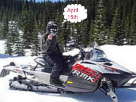
I think he is pickin his nose. Or he might be smelling his finger after pulling it out of his.. Uh.. Nevermind, we aren't supposed to talk like that on TAY right... ;)
author=LeeLau link=topic=13076.msg54600#msg54600 date=1240420449]
Jim - I don't actually know the price. Something like $40? They raised the price because a lot of people were abusing the honour system and skiing inbounds on it.
You can buy the tickets at customer service at Blackcomb or Whistler Base. You have to show you have avalanche gear (nothing about how to use it though or training) and then sign a waiver. I understand it takes some...
I was going to toss my 2 cents worth into the pot just before Amar put up the homestead, so I guess I'm glad i didn't as I would have ended up in the soup line. I was, however, going to say that I believe the NWS does a very good job, particularily given the very complex terrain of the PNW. Forecasting is a probabilistic endeavor. It's not surprising that people may feel the forecast was 'wrong' when the 30% chance of rain (a relative low chance - yet n...
author=snoqpass link=topic=13055.msg54605#msg54605 date=1240424285]
Picture isn't very clear...
Is that some kind of hand signal?
Or maybe some obscure Hyak gang sign?
Thanks Lee. Great info. We'll build some extra time into our schedule to deal with the ticket.
Thanks again for the TR, here and on TGR (full audio, extended re-mix version...crank it up). Awesome as usual.
Thanks again for the TR, here and on TGR (full audio, extended re-mix version...crank it up). Awesome as usual.
author=gravitymk link=topic=13055.msg54594#msg54594 date=1240415045]
Their rules state no snowmobiles.
Their permit expires on April 15th, at which point they suspend operations.
Thanks Amar. I'm planning a return trip to the Cambria icefields next year weather -depending of course
yea that was some nasty weather up there last weekend, good job getting to 12k!
we skiied a shot down to the carbon over the weekend, and i skiied gib chute from the summit yesterday - windy up high, but nothing like what you guys experienced
we skiied a shot down to the carbon over the weekend, and i skiied gib chute from the summit yesterday - windy up high, but nothing like what you guys experienced
Jim - I don't actually know the price. Something like $40? They raised the price because a lot of people were abusing the honour system and skiing inbounds on it.
You can buy the tickets at customer service at Blackcomb or Whistler Base. You have to show you have avalanche gear (nothing about how to use it though or training) and then sign a waiver. I understand it takes some time
edit - i put more pictures and description at TGR to not violate forum rules
You can buy the tickets at customer service at Blackcomb or Whistler Base. You have to show you have avalanche gear (nothing about how to use it though or training) and then sign a waiver. I understand it takes some time
edit - i put more pictures and description at TGR to not violate forum rules
Still wondering where you saw the forecast of 10mph winds . . . although now I suspect that it might have been the point forecast linked from TAY.
I really have developed a personal dislike of those point forecasts, based on seeing outrageous and dead-wrong predictions numerous times. And because they give such a false sense of precision and accuracy, yet have no disclaimer letting users know that in fact they offer no such thing. Perhaps it's some internal NWS/NOAA politics whic...
I really have developed a personal dislike of those point forecasts, based on seeing outrageous and dead-wrong predictions numerous times. And because they give such a false sense of precision and accuracy, yet have no disclaimer letting users know that in fact they offer no such thing. Perhaps it's some internal NWS/NOAA politics whic...
Thanks Amar for all the useful explanations.
I've delved into the prediction models before and have come across consistent comments and reports describing the accuracy that you summed up:
0-3 days Good Predictor,
4-7 days Decent,
7+ days Worthless.
An aside, it's really fun to look at the long-term 3 to 6-month out watershed predictions and see that they have 0 correlation in terms of predicting an average, above average or below average ye...
The ski area has a seasonal use permit for the nordic center.
While the permit is effective, they set the rules.
Their rules state no snowmobiles.
Their permit expires on April 15th, at which point they suspend operations.
At which point their rules no longer apply.
The area in question is USFS.
It is not wilderness or watershed and as such is technically not off limits to motorized travel.
author=arcticcat2 link=topic=13055.msg54585#msg54585 date=1240377862]
I live at the pass, and snomoblie, and ski tour alot, and everyone has a different opinion on this I have run into alot of poeple that work at the ski area that are on a power trip and say no, but I see people all summer on forest service roads on dirt bikes. In my opinion snomobiling is legal at silver peak and you need to stop posting this on line so I can continue to high point the bow...
Articatt, is it your opinion that it is legal or is it the area actually open (by means of legal mandate) to snowmobiles?
author=Robie link=topic=13091.msg54580#msg54580 date=1240365333]
Here is the new experimental forcast link with pointable map. I believe Mike Gauthier had some involvement in its coming to life. ..
I believe this link was recommended/publicized earlier this winter on the Rainier climbing blog started by Gator.
Thanks for the excellent tutorial, Amar! I'd subscribe if you ever decide to get into the forecasting bus...
Great info here - thanks Amar, and thanks to the folks who reported from being up there so I could live vicariously through you. It was relatively calm at Crystal on Sunday. The lenticular clouds were amazing all day. It was great fun to watch them change from one lift ride to the next. By later in the afternoon there was one big one that had a nearly perfect flying saucer shape with remarkably defined edges, beautiful symmetry, and really cool backlighting from the sun toward the west. The clou...
author=Robie link=topic=13091.msg54580#msg54580 date=1240365333">
Here is the new experimental forcast link with pointable map. I believe Mike Gauthier had some involvement in its coming to life. Ive been using it since mid winter along with other products like the recreational forcast.
http://www.wrh.noaa.gov/forecast/wxtables/index.php?lat=46.78436955219954&lon=-121.7406177520752&table=custom&duration=7&interv...
I live at the pass, and snomoblie, and ski tour alot, and everyone has a different opinion on this I have run into alot of poeple that work at the ski area that are on a power trip and say no, but I see people all summer on forest service roads on dirt bikes. In my opinion snomobiling is legal at silver peak and you need to stop posting this on line so I can continue to high point the bowl and tour the south and east side
Thanks for the great info on the forecasts, Amar. Here is Mt R with a stack of lenticulars moving off to north, from University Bridge, Seattle, Sunday afternoon 4/19/09.
Stefan - sorry I am on Norwegian calendar - quite progressive over there you know. thanks - changed the date.
Monika - have sent you tpo file - could not figure out how to attach
Monika - have sent you tpo file - could not figure out how to attach
Here is the new experimental forcast link with pointable map. I believe Mike Gauthier had some involvement in its coming to life. Ive been using it since mid winter along with other products like the recreational forcast.
http://www.wrh.noaa.gov/forecast/wxtables/index.php?lat=46.78436955219954&lon=-121.7406177520752&table=custom&duration=7&interval=6
Thanks for the tips and links Amar. Is this what you call a automated point forcast or i...
http://www.wrh.noaa.gov/forecast/wxtables/index.php?lat=46.78436955219954&lon=-121.7406177520752&table=custom&duration=7&interval=6
Thanks for the tips and links Amar. Is this what you call a automated point forcast or i...
Thanks for the great explanation Amar. I would also like to cast my interest vote.
author=Amar Andalkar link=topic=13091.msg54577#msg54577 date=1240359550]
If there is interest (and if I feel like it), I could try to post a primer on how to quickly find the most useful and relevant forecast output within the vast sea of model output linked from that page. It would take a while to write something like that, though.
Interest? Yes.
(And thank you for what you have provided so far.)
Well, I'll try. One forecast (the Mount Rainier Recreational Forecast, which predicts 71 mph winds) is a mountain-specific forecast prepared by a human being twice a day, using critically important inputs such as upper air data. The other (the point forecast, which claims 18 mph winds) is an automatically-generated forecast based on a grid of data points for which forecasters adjust parameters across broad regions. It is intended (and works best) for lowland locations such as cities and tow...
I skied Granite Mt on Monday April 20, bluebird day, 60+ deg, light breeze. I'd est it will be good at least another week perhaps longer, esp with cooler temps coming. I got to 3000’ on foot via trail, where I started heading N on skins thru the trees, stayed W of that first drainage, making my way in and out of trees, slush snow, esp in sun areas, worked hard on good skinning tech. About time I got out on the S exposure, saw a boarder and skier coming down E side of drainage staying h...
pretty good coverage in those flats. I think it should be skiable for at least the next couple weeks or longer. Lots of folks tracking the place out though.
We arrived at Muir at about 9pm Staurday night after an uneventful skin up from Paradise. We thought things were looking good until about 9000' when the wind picked up quite a lot. There were no more bunks so we tented behind what seemed at the time to be a sufficient wall of snow to keep the wind at bay. The wind seemed to be consistently above 30-40 mph throughout the night, not the ideal conditions to be in a tent. We got up, then delayed, then delayed some more,...
Nice trip. Ive been scoping that terrain for awhile and I am sooo Jealous
Any estimates on how much longer Granite will be skiable?
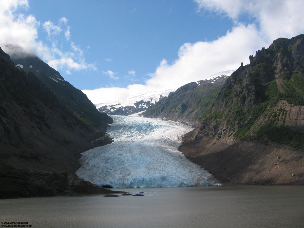
It's right on Hwy 37A between Meziadin Junction and Stewart, BC, near the border with southeastern Alaska, about 1450 km (900 mi) from Vancouver. An amazing place, I was lucky enough to stop by there in August 2002 while driving to Alaska, but haven't found time to return during the skiable season. Here's a summertime view of Bear Glacier and Strohn Lake:

Great trip!
But I got a question. How did you manage to do the trip on "JUNE" 18-19?
By my records, that hasn't occurred yet. Do you have a different calendar than all of us?
But I got a question. How did you manage to do the trip on "JUNE" 18-19?
By my records, that hasn't occurred yet. Do you have a different calendar than all of us?
Could someone clue me in as to where this wonderful place is? I must go there!
Wow. Slack-country extraordinaire. Thanks for the stoke.
What does a Backcountry Access ticket cost these days?
Also, What's the easiest way to pick one up? Can you get one at the Blackcomb Base or do you have to find someone at a Guest Relations office somewhere else?
Thanks in advance for the advice. I suddenly need to visit Whistler again this spring.
What does a Backcountry Access ticket cost these days?
Also, What's the easiest way to pick one up? Can you get one at the Blackcomb Base or do you have to find someone at a Guest Relations office somewhere else?
Thanks in advance for the advice. I suddenly need to visit Whistler again this spring.
author=daveb link=topic=13091.msg54555#msg54555 date=1240342926]
Thanks again Amar for your expert knowledge. Someone pay this man something ;)
I suspect a great many of us will, as soon as the book emerges. Get that sucker on shelves, man!
(My own thoughts on the weather: The predictive power of the forecast models is impressive. It's rare that they're completely wrong; timing seems harder, but my own meta-a...
Thanks again Amar for your expert knowledge. Someone pay this man something ;)
author=CoachingEndurance.com link=topic=13091.msg54516#msg54516 date=1240290977">
the weather looked perfect. 10 mph winds and 15 degree temps forecasted at the summit for sunday, with partly cloudy.
. . .
i'm pissed at the weather man.
Matt, thanks for the report. We met in the parking lot on Sunday morning beside your van. I don't mean to be critical of you, but I'm completely baffled as t...
Nice trip! Those are some sweet lines for sure!
Nice! Looks great
No need to apologize Monika. Never forget that you were a member of the Champion Kokanee Hut Brainiac Team.
"Go team brain injury"!!!!!
"Go team brain injury"!!!!!
West bowl is pretty cool....You get more skiing in than just blasting down the south face.
Too bad the trip didn't work out. I had some friends go to Muir on saturday and they said the wind was very strong above about 9k.
On the weather:
Are you not from the PNW? The weather man is rarely correct.
I've threatened for years to setup a random weather forecast website and compare that to forecasts made by the news, noaa, etc. We could see if there was any improved correlation between a random prediction and the weather man......
That's a great looking tour! Way to use the last few days of the lift to its full advantage ;)
Monika - i'll draw it up - cool to cover 3 usgs maps in one trip! sorry for the rambling.
Welcome to the board.
Watch out for what the little birdie tells you.
Sexy skis.
Watch out for what the little birdie tells you.
Sexy skis.
author=Eli3 link=topic=13077.msg54456#msg54456 date=1240204441]
Interesting that it wasn't THAT windy on the Muir snowfield - we were across the nisqually having a go at the finger and got to about 9,400 feet before we could barely stand up.
That is why I ski on heavy skis and boots. It helps keep me bottom side down. ;D
The wind was a bit much. I was curious to check the telemetry recordings and see just how strong...