TR Replies
Sounds like today was better. We got a late start and made it up Pan Point easily with ski crampons. Kept crampons on until above Pebble Creek, then it was great gliding to camp and no crampons needed if you picked a good line.
Good chalky skiing until about 8000, then a bit uneven and grabby. Easy to connect edgable snow with only a few ice patches that were easily crossed. Fun skiing down pan face, heard heading down the other side towards Fourth Crossing was good as well.
Good chalky skiing until about 8000, then a bit uneven and grabby. Easy to connect edgable snow with only a few ice patches that were easily crossed. Fun skiing down pan face, heard heading down the other side towards Fourth Crossing was good as well.
Some friends and I visited Paradise Glacier basin on Friday, and I brought some ashes to scatter. Thanks to Steve for holding the camera.
Remembering my wife Steph, in body and spirit, November 20, 2015, Mount Rainier National Park.

Remembering my wife Steph, in body and spirit, November 20, 2015, Mount Rainier National Park.
;)
author=GnarBLane link=topic=34840.msg143244#msg143244 date=1448218270]
I'd never been to white pass but heard good things. Figured since I had 2 dogs for the weekend I'd venture up to White Pass and check it out.
What a great day, maybe 5/6 people total all day. Skinned up past chair 6 to high point on the west ridge. Great snow, cold fluffy powder. Really great early season turns.
https://vimeo.com/146556001
In the summer of 1995 I biked around the island on the Ring Road, back then it was more than 70% gravel. It was one of the best trips of my life, despite the not so great weather. A return to Iceland has been in my head for a long time and your trip report brought all that back to forefront. I just need go and experience that beautiful virtually treeless landscape again. Great photos! Thanks for TR!
Skier dude was OK. Watched the group scoot out the valley.
Fun seeing you too Norseman. I'm glad I avoided all ice-capers via the 4th crossing.
Tabski, you must be cynical because you were at work.
Tabski, you must be cynical because you were at work.
Kinda cynical TR for a sunny day on the big one -- at least that's what is reads like to someone who was at work ;-)
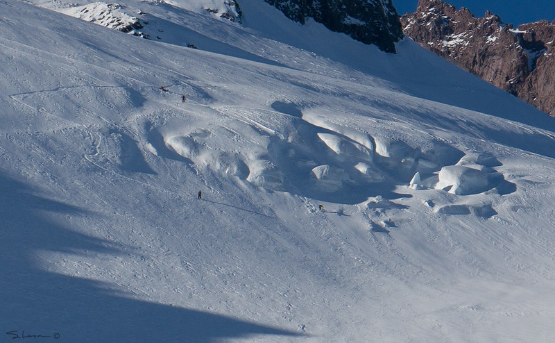
What's the deal with that fallen glacier skier? Hope he was ok. If Norseman's final image isn't heaven I don't know what is.
What's the deal with that fallen glacier skier? Hope he was ok. If Norseman's final image isn't heaven I don't know what is.
I'd never been to white pass but heard good things. Figured since I had 2 dogs for the weekend I'd venture up to White Pass and check it out.
What a great day, maybe 5/6 people total all day. Skinned up past chair 6 to high point on the west ridge. Great snow, cold fluffy powder. Really great early season turns.
https://vimeo.com/146556001
What a great day, maybe 5/6 people total all day. Skinned up past chair 6 to high point on the west ridge. Great snow, cold fluffy powder. Really great early season turns.
https://vimeo.com/146556001
Ice-capades indeed...
Here's my contribution to that theme: group leader falling and tumbling off the ice cliff while threading his inexperienced party through the early season bridges out on the Paradise
... otherwise, skiing was quite enjoyable on sheltered slopes. Good to see ya out there, Kamtron.

Here's my contribution to that theme: group leader falling and tumbling off the ice cliff while threading his inexperienced party through the early season bridges out on the Paradise
... otherwise, skiing was quite enjoyable on sheltered slopes. Good to see ya out there, Kamtron.
author=cascadekid link=topic=34848.msg143227#msg143227 date=1448143833]
I gave up trying to post photos. This site sucks to use.
1. Point your browser to http://www.imgur.com (if you're on a mobile device, imgur offers an app for all platforms)
2. Upload your photos there, you don't even need an account
3. For each image you want to share, put it inside a pair of img tags
Mazama ridge was a nice alternative. It was fun seeing everyone
Thanks for the confirmation of my fears - and that 50 miles on the bike in the sun was a good option,
author=the_flying_v link=topic=34840.msg143231#msg143231 date=1448164213]
All the young, hard charging White Passers stay in the back bowls and don't post about it. That way all the suits stay at Crystal; it's better that way.
-SM
ouch. I appreciate the post filbo. I wonder the same thing all the time. "Why am I the only one here?" Keep it up!
All the young, hard charging White Passers stay in the back bowls and don't post about it. That way all the suits stay at Crystal; it's better that way.
-SM
-SM
author=filbo link=topic=34840.msg143217#msg143217 date=1448077871]
Where are all the young hard charging snow fanatics?
Hey Phil, sounds like you're the hard charger for WP. Here's hoping for Good season!
Another vote to rotate the chart 90deg clockwise. Life makes a lot more sense to most people with time moving left to right on the y-axis
I think i might have gotten highest on the road on Saturday, but it came at the cost of having to pull the guy out in front of me a few times while people parked lower down passed us skinning up the road.
Saturday was rad, but definitely a crowd up there. Everything felt really stable then, but with 2 weaker layers, I don't doubt everything moved with higher temps.
Talked to the dude who's truck it is on when we were driving down. They were trying to go get it at 5:30pm in...
Saturday was rad, but definitely a crowd up there. Everything felt really stable then, but with 2 weaker layers, I don't doubt everything moved with higher temps.
Talked to the dude who's truck it is on when we were driving down. They were trying to go get it at 5:30pm in...
Thanks Lee for the timely update, I was just wondering whether it would be worth going back this weekend, sunny forecast and all. Maybe, maybe not.
Bummer about the truck, the cost of pulling it out might be more than the truck is worth; I just hope nobody got hurt.
Bummer about the truck, the cost of pulling it out might be more than the truck is worth; I just hope nobody got hurt.
Took a lap up there yesterday, Nov 18th. The highest any vehicle made it was the big curve @ 3450' that left them with a ~2mi walk to TH. Looks like someone's T100 is up there for the winter about 1mi from TH unless they can work some magic before the next storm.
Could skin/ski most of trail still but rain definitely washed some of it away down low. Stout rain crust with a skiff of new snow up to 6000' and probably higher. Best skiing in E'ly low angle concave fea...
Could skin/ski most of trail still but rain definitely washed some of it away down low. Stout rain crust with a skiff of new snow up to 6000' and probably higher. Best skiing in E'ly low angle concave fea...
author=ErikT link=topic=34792.msg143138#msg143138 date=1447800005]
nerdery; dig it. where did you make the chart? matlab?
Gnuplot ( http://gnuplot.info )
@Leichty - thanks!
Great pictures and that chart is sweet!
More awesomeness. Thanks for sharing, guys!
author=Sidecut link=topic=34767.msg143073#msg143073 date=1447644973]
Nice work! We're thinking of heading to Winthrop next weekend - are there any relatively easy to access areas for backcountry turns if the 20 stays closed?
WSDOT often plows up to Delancy Ridge in the early season. You can tour right up from the snowpark if that's the case. You could also bring beer and a tow rope and barter for a tow up to...
nerdery; dig it. where did you make the chart? matlab?
That looks really cool, Charlie. Here are my suggestions:
1) use a different color palette;
2) put F scale on the top (set x2tics ...) (could put m on the right, too);
3) animated .gif that adds the points one-by-one.
:-)
1) use a different color palette;
2) put F scale on the top (set x2tics ...) (could put m on the right, too);
3) animated .gif that adds the points one-by-one.
:-)
The data come from a Garmin Fenix and an associated wireless temperature sensor on the back of my pack. It's affected by sun (so is snow!), but on cloudy days like Sunday, it's a consistent measure of air temperature.
Units-wise, I've become convinced that celsius is the right unit system for anything involving water. Having zero at the most important phase transition is a good idea...
Units-wise, I've become convinced that celsius is the right unit system for anything involving water. Having zero at the most important phase transition is a good idea...
Charlie, the chart is fun. Where does the data come from? A personal weather monitor? It looks cool, and I like the Celsius. Would be even better if you go fully metric ;)
Personally, as a dumb American, prefer Fahrenheit . I don't really like military time, but if you are going to use it, would be better written with 4 digits, ie. 1430 or 1200.
I come for the photos Silas ;) lets see em
Thanks for all your thoughts!
Photomatt: The horizontal colorbar is a great idea; I think left-to-right, too. Automated arrows sound like an interesting challenge.
Brent: The cool thing about plotting with height is that you can see the 'lapse rate' , the decrease of temperature with height. Imagine what the plot might look like if I'd climbed out of an inversion.... I'll see if there's a clean way to roll both approaches into one plot.
G...
looks like a psychedelic dinosaur with a gopro. Cool!
Way to say it, John. Today was my first day and I couldn't possibly hit the fine point any better. A long lost friend indeed. And the sunrise over Shuksan and the North Fork peaks told me "we never went away."
I think the amount of people this weekend at the area is only a prelude to what will happen on powder days this year. With Mt. Baker ski area opening this Thursday, I can bet first tracks on the main runs will be finished within 15 minutes! To those riding the lifts on a big powdery day, enjoy your powder minutes!
I like the idea of combining time, altitude and temperature. I suppose in some way they are necessarily confounded. To me, it would be easier to read intuitively if time was on the x-axis and temperature and altitude were plotted as independent traces on the y axis.
Thanks for the photos and TR! Cool plot, but it did take me a few seconds to figure out how to interpret it. A few suggestions to make it more intuitive:
- rotate the colorbar horizontally. I think of time running horizontally instead of vertically.
- re-label the times as hours. E.g. "1 pm" instead 13, etc.
- you could automatically add some arrow/text annotations, e.g. "car" at the beginning/end, "top" at the high...
Cooooooooooooool Photos!
You captured the essence of autumn transitioning into winter. Sounds like a great solo meditation.
I like the beta infographics too!
You captured the essence of autumn transitioning into winter. Sounds like a great solo meditation.
I like the beta infographics too!
100+ cars in November before the ski area is open? That's nuts.
Welcome to the Wash-atch. ::)
Welcome to the Wash-atch. ::)
Thanks for your post. Climate change is THE BIGGEST DEAL & challenge for our planet! We need to tell our elected reps to Vote for the Environment or we will vote for some one else. Sorry for the thread jack.....
Awesome, thanks for the update!
We parked 1.8 miles down the road from the trailhead, making it farther than any other cars (and helping 2 folks who got stuck). There is ~ 2' on the road and, needless to say, we could skin and ski the whole trail :-)
author=avajane link=topic=34791.msg143090#msg143090 date=1447706955]
The backcountry will be more in the backcountry.
:D Not bad at all!
Thanks kamtron! How was the road? Can you skin form the parking lot yet?
Yesterday was awesome up there. There were many groups getting laps in the bowl. No noticeable instabilities, although there was evidence that steep slopes to the S end of the first bowl slid in the storm. It's deep out there---felt like 2.5'. Faceshots readily available.
The backcountry will be more in the backcountry.