TR Replies
Cool tour! Thanks for posting.
Corn skiing was pretty good, though the snow pack melting out fast up there this season, some lines no longer go (already).
My observation at about 4k on North facing was roughly between 2~3' snow depth.
Git'r while you can.
My observation at about 4k on North facing was roughly between 2~3' snow depth.
Git'r while you can.
I was also in this area on 4-30 and 5-1. What an amazing weather window for spring skiing! I camped at about 6K feet on 4-30, and skied Iron Peak on 5-1. If anyone wants to see photos of the bear cub foot prints in he snow, I can got some good photos of them. You can view them in my photo album below:
https://www.facebook.com/the808/media_set?set=a.10153662835212613.107374...
https://www.facebook.com/the808/media_set?set=a.10153662835212613.107374...
Great day to be on Silver Peak. Almost did not happen! The road prior to the cut off to Mt Catherine has a significant amount of snow making it impossible continue. Was turning around when I met Art. Not wanting to go alone we teamed up to give it a try. Walked the first hundred yards then skinned up when the snow appeared to be continuous. Let our shoes behind (big mistake) then continued on. The road cleared at the Mt Catherine trail head and we continued on in ski boots for close to 1....
I'd never seen Bear tracks follow a skiers skin track before.
Saw a cub two weeks ago SW of Earl. I've seen Cougar tracks in my skin track from the previous day.
Everything like an easy walk - or snack.
Saw a cub two weeks ago SW of Earl. I've seen Cougar tracks in my skin track from the previous day.
Everything like an easy walk - or snack.
The NPS has issued citations to friends of mine who biked the Summerland closed (by a sign)road. beware. not sure if this is a current practice.
Cayuse pass is open ,Chinook still closed .White river road gated at 410. Supposed to open May 16 per Park website.
Am I interpreting correctly that you cannot drive the White River road? Where is it gated?
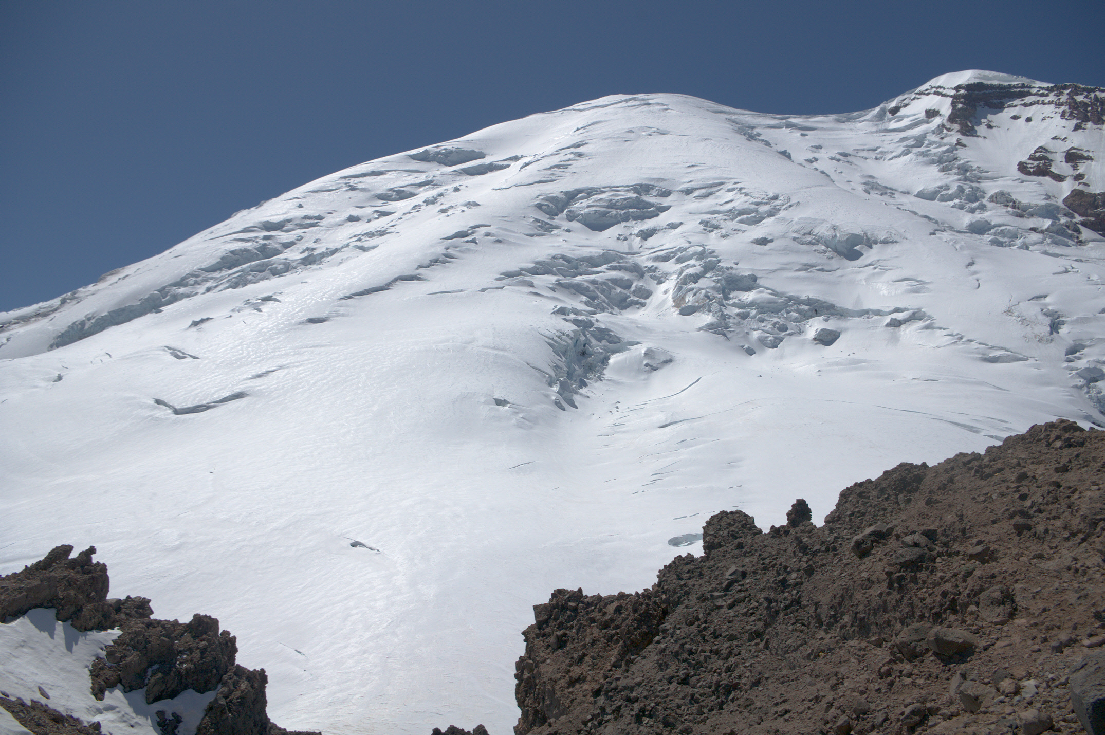
Emmons from the prow: big photo
A party of two skied up to Camp Schurman yesterday to go for the Emmons route today. And I came across another group of two climbers along the trail on my way down, not sure what their plans were.
A party of two skied up to Camp Schurman yesterday to go for the Emmons route today. And I came across another group of two climbers along the trail on my way down, not sure what their plans were.
Jealousy is high. Any shots of the Emmons?
we made it in an Outback with no problem. there are a two minor wash outs where you could get high centered if not careful.
" Gonna try north facing tatoosh tomorrow even if I have to sneaker walk ."
The sneaker walk. This is an exercise for the young. ;)
The sneaker walk. This is an exercise for the young. ;)
Very nice reporting on multi discipline touring.
Thanks for inspiring report! Great pics as usual.
how was driving Sunrise Mine Rd? A recent report on WTA.org made it sound like there were some washouts that only a high-clearance vehicle could handle- curious if you think an Outback would have any problems.
Beast!
Yeah one of these days I need to do a big line to be "cool like Carl"😄
Yeah one of these days I need to do a big line to be "cool like Carl"😄
http://www.wta.org/go-hiking/trip-reports/trip_report.2016-05-04.0050882937
Edit: ^ he beat me to it.
Edit: ^ he beat me to it.
wta.org has recent trip reports from Ellinor.
I don't know but I have that same question about Silver Peak. The chute is cool on Ellinor but I kind of like the summer trail route for a more wide open shred. Respectively we may just have to go and find out!
great photos and report!
Indeed! You just made my heart beat faster... I've looked at all of those peaks, longing to ski. Some day soon!!!
Oh man, That was funny... and
1. I have a new favorite song
2. The yellow bird out of nowhere was amazing!
1. I have a new favorite song
2. The yellow bird out of nowhere was amazing!
Thank you, Dan! I have some ideas how to do even it better ;) For starters, spend 4 days to a week. Skip Deception and just ski all around - so much incredible terrain. The slopes in Deception Basin, Fricaba, Hal Foss, and Mystery peaks looked fantastic. This place is a gem and the views are incredible.
Amazingly Kül!!! I love that place and you two did it right. Thanks for the beta.
Charlie, I am not sure if I understand your statements about the deproach route. Did you head out via the valley below the N. side of Ragged Ridge past Kitling Peak and Lake, but not all the way around to the Easy Pass trail, just straight out to the road? I have wondered about cornice hazards on the back of the ridge in there.
Any chance you, or anyone else up on Silver Star last weekend, retrieved an ice axe left at the top? I didn't realize I forgot to reattach it to my bag until I got back to the car. If you found it, PM me. Thanks.
Zap, after what happened last time, you go skiing in the rain/fog, in a known pollen area! I am beginning to question your judgement, buddy. I may head over to the the Teanaway area next couple days (will still bring pollen kit, which is basically a small bottle of Goo Gone and some rags), but have not heard of any pollen there. Obama is trying to get funding for the pollen early warning system, but can't get it through congress.
author=LangleyBackcountry link=topic=36419.msg148505#msg148505 date=1462470435]
Wow. What did the snow level look like on the S side of Ingalls Creek (N side of Teanaway peaks) and around Ingalls Lake and Headlight Basin/Fortune? Trying to decide on a destination for the weekend next week.
Coverage looked pretty decent a week ago. It looked like most northern aspects still had snow down to Ingalls Creek. We didn't get a view...
Wow. What did the snow level look like on the S side of Ingalls Creek (N side of Teanaway peaks) and around Ingalls Lake and Headlight Basin/Fortune? Trying to decide on a destination for the weekend next week.
I have a theory on The overnight hikers that fucked the parking In LoT4.
I think they were told to park, front of car along snow wall. My guess is their leader figured 150 cars lined up side by side front facing would make towing away difficult.
So they lined em up along the entire wall instead of lumping the cars next to the trail.
Summit Corp. was useless in assistance to it's guests.
Thanks Glenn...that's what I meant...the nw slope that empties into bean basin. I'm hoping I can still cross the creek there where the upper basin opens up.
Erin and Kurt - this is a good trip!
Thanks for the report. I finally have a chance to get out for a few days next week and I was hoping to do some skiing in that area so this is very helpful.
author=androolus link=topic=36431.msg148481#msg148481 date=1462401891]Skied the NW shoulder Monday before dropping into the basin on continuous if mushy snow(skied off the summit ~4:15). It's going fast. We had to hike more than an hour(Oh, the humanity!) from the trail head before hitting skiable snow where the upper basin opens up.
How does the SW face of Earl peak look? Does it still have snow?
Well considering there were a lot of people who appeared to be using crampons for the first time I would say not that difficult. Around 15 steps on all fours with crampons and axe. There is a nice trough at the base to provide some added comfort.
Haha, this post just changed my day for the better. Man I needed that laugh. Think the soundtrack may be my favorite.
How does the SW face of Earl peak look? Does it still have snow?
I never be able to listen to that song the same way again 8)
I love that area! I went in there a couple years ago. Sounds like conditions are similar to when I went in. I am looking for a destination for the weekend of the 14th and am thinking this might be too cooked out.
My report from 2014 is here: https://langleybackcountry.com/2014/05/18/delayed-gratification/
My report from 2014 is here: https://langleybackcountry.com/2014/05/18/delayed-gratification/
author=ADappen link=topic=36413.msg148473#msg148473 date=1462388336]
Looked like a beautiful day, though maybe warmer than ideal?
Actually, the temperature was quite comfortable (it was breezy), and the snow didn't over-soften too much. For early May, I think the snow this year is more consolidated than normal.
... and I showed that guy how to open a beer with another beer after which he asked, "What do you do when you only have one beer left?" Obviously you go to the store for more!
Glad you and the other uphill-inclined folks enjoyed the Lot 4 festivities. The group returning from an overnight glacier skills course was less enthusiastic about being parked in...
Glad you and the other uphill-inclined folks enjoyed the Lot 4 festivities. The group returning from an overnight glacier skills course was less enthusiastic about being parked in...
author=slien link=topic=36413.msg148443#msg148443 date=1462324767]
We weren't sure exactly where the summit of Big C was, but getting up there without some serious technical climbing didn't look possible.
I think the Volken guidebook is wrong in its description of Big Chiwaukum. Once you pass the east spur of Point 7804, there is no route up the east side of Big C that doesn't involve serious technical climbing. Plus, mos...
Nice effort all. Looked like a beautiful day, though maybe warmer than ideal?
I just logged into my TAY account for the first time in four years to let you know that you bros are A DAMNED INSPIRATION. Thank you for making my day!
Congratulations on the historic feat. Has Pit Viper called to offer sponsorship yet? (Seriously)