TR Replies
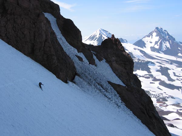
I thought a bit about Ben Thompson while looking across the Thunder Glacer from camp. The following morning, looking down the Deming I thought of him again. That's a mighty steep gorge! Their perseverance must have been remarkable to wait out the storm in Kulshan Cabin and then continue on to cross this. I wonder why he chose this route - the Colfax saddle is clearly the easiest way. If they had chosen this route, they perhaps would have completed the traverse. &nbs...
Parked about a quarter mile from the TH.
Hiked to about 6500' and skinned from there to the top.
I used ski crampons/ice axe on the climb from the Lunch Counter to the False Summit.
Hiked to about 6500' and skinned from there to the top.
I used ski crampons/ice axe on the climb from the Lunch Counter to the False Summit.
Nice job Kam and friends. Looks like a great time with a good weather window. ;D
It was the Olympia branch of the Mountaineers, basic climbing class.
Thanks for the report, Brent.
Sounds like you parked fairly close to Cold Springs?
Sounds like you parked fairly close to Cold Springs?
Good info, Marmot.
Thanks.
What group was doing the crevasse rescue class?
Thanks.
What group was doing the crevasse rescue class?
Good words, JWman.
As I recall, Mad Dog, that Ranger that gave us a ride last year was female. So what am I getting at? Uh, oh well, I think I'd better drop this before I get into trouble ;D
She probably just felt sorry for us.
Here's a shot of the world famous Jerry of JW Designs, crankin' out corn on the Foss:

As I recall, Mad Dog, that Ranger that gave us a ride last year was female. So what am I getting at? Uh, oh well, I think I'd better drop this before I get into trouble ;D
She probably just felt sorry for us.
Here's a shot of the world famous Jerry of JW Designs, crankin' out corn on the Foss:
Nice TR Matt. It was an amazing trip, one that I was glad to be a part of, even though the one day push seemed to go on forever and ever and there were many nerve racking moments. This trip did teach me much about ski-mountaineering and I also now have a new found respect for Mount Baker from traversing/skiing the magnificant Mazama and Park glaciers.
One more thing, I highly recommend ski crampons for those that have compatible bindings.
Joshua
One more thing, I highly recommend ski crampons for those that have compatible bindings.
Joshua
Nice report, Matt. It's great to hear of people doing imaginative trips.
You mentioned the 1932 partial orbit led by Ben Thompson. It's hard to overstate the importance of that trip. It was, as far as I can tell, the first real alpine ski traverse done in the Northwest. It was years ahead of its time, I think. I've found no other written references to ski mountaineers carrying multi-day packs and camping out on snow above timberline for days in a row in the Cascades until the 1940s, and e...
You mentioned the 1932 partial orbit led by Ben Thompson. It's hard to overstate the importance of that trip. It was, as far as I can tell, the first real alpine ski traverse done in the Northwest. It was years ahead of its time, I think. I've found no other written references to ski mountaineers carrying multi-day packs and camping out on snow above timberline for days in a row in the Cascades until the 1940s, and e...
Wow. I am truly inspired. Thanks for the great TR.
Scotteryx,
Nice report. Sounds like a really fun climb. Nice job holding out for 17 hours!...gotta love those long and hard days.
-kam
Nice report. Sounds like a really fun climb. Nice job holding out for 17 hours!...gotta love those long and hard days.
-kam
It was another great day in the PNW and yet another great "corn" harvest alright!! Don't know why I could get that ride, it's worked before, even got a lift from the Park Ranger ;D
We did have a good day on Sunday, and it won't be much longer until Foss will have to wait until next year. Sounds like you had a good day also.
Nice report Kam, sounds like you camped about where we did. See you soon 8) JW
Cool.
Isn't this a great forum.
Thanks, Jon, for the update.
Kam, did I miss Jerry's report somewhere? >:(
Charles, you done good coming up with this forum.
It's a great tool.
Thanks.
Isn't this a great forum.
Thanks, Jon, for the update.
Kam, did I miss Jerry's report somewhere? >:(
Charles, you done good coming up with this forum.
It's a great tool.
Thanks.
The log was removed by Sunday afternoon. The road should be passable to the trailhead by this wknd.
Hey Ron,
Thanks for the kind words. I didn't see the tree, only heard about it from other skiers. You know me, I prefer the less traveled route...bush whacking!;D I'm sure the road will be clear by this weekend though if you decide to head that way.
Say, nice turns on Foss Peak with Jerry and Mad Dog!
-kam
Thanks for the kind words. I didn't see the tree, only heard about it from other skiers. You know me, I prefer the less traveled route...bush whacking!;D I'm sure the road will be clear by this weekend though if you decide to head that way.
Say, nice turns on Foss Peak with Jerry and Mad Dog!
-kam
Nice report, Kam.
Thanks.
Great viddy too.
Looked like a great trip.
How big was the fallen tree that blocked the road?
Thanks.
Great viddy too.
Looked like a great trip.
How big was the fallen tree that blocked the road?
I've not done it, but a friend of mine did the tour earlier, like as soon as the road was clear (several years back). The transition zone in the woods sucked on the ski out, but otherwise he said it was great, especially with the boulder field well-covered. He did it as a long sick day trip, and so was travelling pretty light up the approach. But for what it's worth, he won't go back to do it again with me.
Micheal,
Sometime try accessing Eldorado from Sibley Creek with the Triad bypass. A lot less pain and mucho more views. There's one tricky part bypassing the Triad, but otherwise fairly straightforward.
Bill G
Sometime try accessing Eldorado from Sibley Creek with the Triad bypass. A lot less pain and mucho more views. There's one tricky part bypassing the Triad, but otherwise fairly straightforward.
Bill G
Great photos, thanks for sharing. You really lucked out with the weather for all your trips.
Those chutes were in especially great form that day. The best snow I've seen in there in a long time. Would have been fun to meet you guys and finally put a face with the name. Maybe next time.
Well, I should let the guilty party speak for himself, but he didn't mention needing any aloe vera for a raspberry. He did say something about needing to change his diaper, though!
Yep, that was us.
You guys looked real good on your boards -- really had your way with that chute... nice job.
Except it looked like one of you fell and slid about half way down.
There was a really long fresh butt glissade track when we skied it. Musta been the rookie of the group, huh?
;D
You guys looked real good on your boards -- really had your way with that chute... nice job.
Except it looked like one of you fell and slid about half way down.
There was a really long fresh butt glissade track when we skied it. Musta been the rookie of the group, huh?
;D
Hey Mad Dog & Ron - guess we were the 4 snowboarders you spoke of - I dropped in first - wow, what a wonderful ski, eh?
Were you the folks hanging on the rocks at the entrance when we dropped in? I think I remember hearing voices over there, but my mind was kind of occupied...and hearing voices is nothing new.
Were you the folks hanging on the rocks at the entrance when we dropped in? I think I remember hearing voices over there, but my mind was kind of occupied...and hearing voices is nothing new.
Yep. That's one of my faves.
Nice report.
Nice report.
Man, yet another excellent photo Amar! These photos seem to be guidebook quality! ;D Thanks for posting these, it's definately putting a smile on my face before work.
Reflecting back on that day, this tour has got to be noted for the unbelievable sensation of climbing what seems like a medium sized random peak and then cresting over the ridge to see one of the most classic and unbelievable views in America.
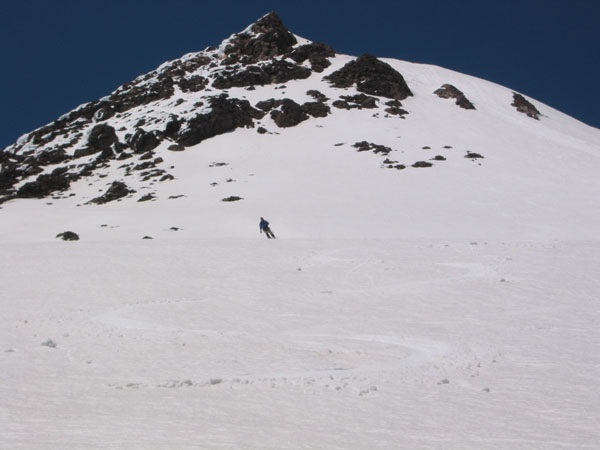
Sky launches down the moderate 40-45 degree slopes of the main chute above the Prouty Glacier, after our traverse left out of the much steeper southern chute. In the background are Middle and North Sisters.
Click here for a double-size version of this photo.
Click here for a double-size version of this photo.
Nice photo, man. That shows the line we skied perfectly. As I said before, my next trip here will be a 2-3-4 day venture either ultra-light or with a basecamp to ski all those lines on the other side of the photo.
Ahh, so nice to think back on last week. It seems you have still been busy this week right Amar? After 4 days of mostly laziness except for work, I'm itching to go ski another peak. I'm out this weekend, but am totally free the next 3. I'll get in touch with y'all, I have some ideads, I'm sure you do too.
The Northwest Bowl of Mt Washington from Big Lake, with the middle portion of our ski descent shown in red. The upper portion of our route followed the narrow snow finger above the red line, and then the leftward angling snowfield to the North Ridge (see the larger photo). The lower portion of the ski route is down in the woods.

Corey skiing the perfect corn on the lower part of the Wyeast Face near 9000 ft. We skied through the gap between the two rightmost large rock outcroppings. The sluffs we set off on the steep upper face are visible at right.
Click here for a double-size version of this photo.
Click here for a double-size version of this photo.
The southwest side of Diamond Peak from a clearcut on Road 2149, about 5 minutes hike from where we were car-camped at 5800 ft. I finally managed to stagger awake around 10 am, and this photo was taken at 10:35 am, just after Corey and Cyril reached the summit. You can see them up there, but they're really small! I also drove around that day to get photos from the north and east sides of the peak, and there is much more snow on those other sides. Although the approaches a...
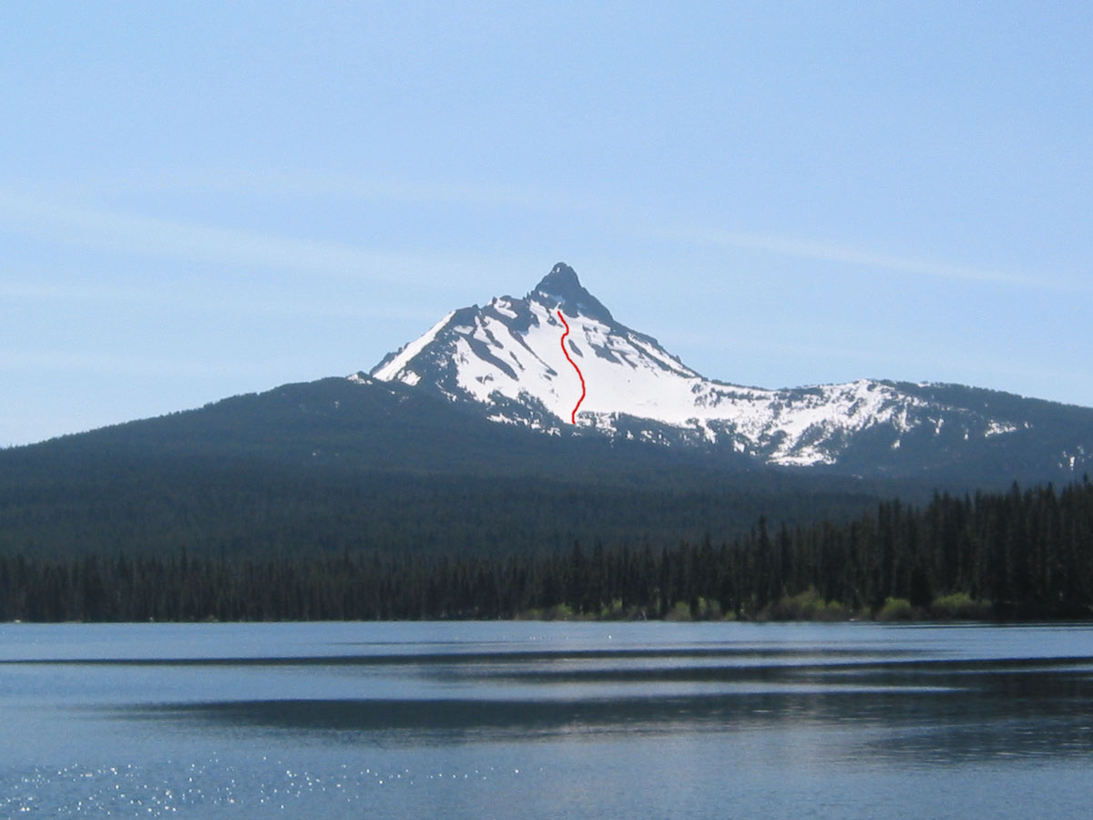
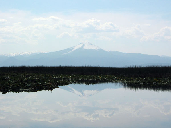
Mount Scott mirrored in the waters of Klamath Marsh, located just east of Hwy 97. This photo was taken the day after our ski descent, unfortunately late in the afternoon (it should have been a morning shot). The view looks west, and the Southeast Chute is the prominent showy chute angling down and left below the summit.
The Northeast Face of Lassen Peak from the Devastated Area Trailhead, taken after our ski descent. Our ski route up to the North Ridge is shown in blue (the upper part is hidden behind the right skyline), with the ski descent shown in red. The debris from the massive sluffs we set off is easily visible to the right of our descent route (skier's left).
Our ski route down the West Face is shown in red, including the downhill traversing exit from Hidden Valley back towards Horse Camp. This photo was taken at 8 pm the evening before the ski descent, from the Abrams Lake Road overpass on I-5 just north of Shasta City.
Click here for a double-size version of this photo.

Click here for a double-size version of this photo.
I've decided to go back and add a photo to each of my recent trip reports, since it might be a long time before I get around to posting a full trip report with photos on my website.
This is kind of a blank and featureless photo, but it shows the sweet turns on the morning corn, heading down from the true summit of Mt St Helens.
This is kind of a blank and featureless photo, but it shows the sweet turns on the morning corn, heading down from the true summit of Mt St Helens.
Gnarly.
I'm impressed.
Nice Job.
Great report, great pictures. Keep up the good work.
I'm impressed.
Nice Job.
Great report, great pictures. Keep up the good work.
Sky,
Great TR,photos and ENTHUSIASM ! ;) Zap
Great TR,photos and ENTHUSIASM ! ;) Zap
In May, 1987 I skiied to Primus Peak with a visiting California skiier. then returned to Eldorado and exited via the west side of the ridge to Quien Sabe Glacier (not completely straightforward, requiring a rappel), and down the Boston Basin trail to the road. I'm not sure why we didn't cross Sahale Mtn and go down Sahale Arm. That seems like it would be a better exit. Is it possible to easily cross from Boston Glacier back over to the west side of the ridge?
This, along with the region s...
This, along with the region s...
Guess I should have put the pic in a new post so the thread would come up again so everyone interested could see Steve's pic. Oh, well, this'll do it :)
Thanks Phil. I guess we got reliable information from the RS about the 2329 on the Takhlakh side, but not the northern approach (we were told snow blocked the 2329 at about Keenes Horse Camp, which would be at least 2 miles from the Killen Creek TH). Still, we probably would have choosen Takhlakh since it led more directly to our desired base camp.
We met up with Sam & Bill on Saturday afternoon. We were able to drive all the way to the trailhead from the north. Continuous snow started at around 5000ft if I recall (after about a mile of walking on the trail).
Yes Charles, correct on both counts. ÊI'd try going in at four corners towards Potato Hill and travel the margin between the lava flow and Muddy Fork R. ÊThanks for the additional info on the Garden. ÊPerhaps its more of an April or May trip.
David
David
Apparently, most of the pollen particles don't stick to skis, most of the time.
Mark, this is a good way to state my basic conclusion. I've been thinking about starting a thread where we could gather people's observations and theories in one place, and maybe gain more insight into this problem (edit: the thread can be found here). My experience i...
Is the northern lava flow skiable at this time of year or at any time for that matter, similar to the Aiken flow? I've been interested in making that tour from the four corners.
Thanks for the informative report.
David Lowry
Thanks for the informative report.
David Lowry
Thanks for a great report, Charles. The pleasure you take in being on the snow and in the mountains, and the curiosity with which you approach the world in general, is clear with each paragraph. Very refreshing.
Pollen issues have been puzzling me each spring, but I don't usually spend long enough skiing a confined area at different times of day to notice the sorts of striking differences that you did. I'd always assumed there were localized patterns of pollen deposits,...
Pollen issues have been puzzling me each spring, but I don't usually spend long enough skiing a confined area at different times of day to notice the sorts of striking differences that you did. I'd always assumed there were localized patterns of pollen deposits,...