TR Replies
The exit hike saw my eyelids the heaviest they've ever been at the end of a big day. I kept thinking how it seemed quite likely I could close my eyes and stumble down the bank into the creek during the bonus 3.5 mile exit to the bridge.
What were we thinking?
Thanks for the entertaining report, Sky. I'm glad you managed to avoid the creek.
Are you saying that this was your hardest-core trip yet, or did you just get soft the last c...
Thanks, that's great news. Here's a more direct link to the MBSNF website, Schriebers Meadow is CLOSED to snowmobiles [updated 4-28-2004">.
Only open when the snow depth exceeds 24 inches at the trail head. It is the snowmobile drivers responsibility to observe this requirement. The"NO WHEELED VEHICLES BEYOND THIS POINT" signs must be obeyed regar...
Only open when the snow depth exceeds 24 inches at the trail head. It is the snowmobile drivers responsibility to observe this requirement. The"NO WHEELED VEHICLES BEYOND THIS POINT" signs must be obeyed regar...
http://www.turns-all-year.com/skilinksfr.html
According to the above: Schreiber's Meadow is now closed to Snomobiles.
Sorry the URL does not work. But it is a link that can be reached from this website in the "access links" section.
Go to "winter recreation" and "more information about snomobiling". Or take my word for it.
According to the above: Schreiber's Meadow is now closed to Snomobiles.
Sorry the URL does not work. But it is a link that can be reached from this website in the "access links" section.
Go to "winter recreation" and "more information about snomobiling". Or take my word for it.
Jeff, Thanks for the photo of the Mammoth Crest. It is a beautiful area. I just compared notes of the trip with another mature skier and we agreed that it is a long slog. But then we're 58 and 60 :)
After retiring 4 years ago, I have become irresponsible. More people should retire early while they are still healthy and "above ground". Jeff, I look forward to placing some signatures on a montain with you. Zap
After retiring 4 years ago, I have become irresponsible. More people should retire early while they are still healthy and "above ground". Jeff, I look forward to placing some signatures on a montain with you. Zap
MW8888, Thanks for the great photo of Mt. Tom. The Rock Creek road is now open to Mosquito Flats, about 10,200' A great place to start skinning.
Ron, I do have a digital camera and have also used my video camera to film the trip's ascents,descents and surrounding terrain. I just have been too lazy to learn how to post any of the photos. Is there a Cliff Notes version on how to post photos ? You have to remember that I am Polish :)
Zap
Ron, I do have a digital camera and have also used my video camera to film the trip's ascents,descents and surrounding terrain. I just have been too lazy to learn how to post any of the photos. Is there a Cliff Notes version on how to post photos ? You have to remember that I am Polish :)
Zap
Right on, nice enduro-trip! Brings back memories of trying to climb Jack. Big, broad mt. Jack is. After spending the better part of a day just getting to the base of the actual climb, we gave up neither wanting the 23 hour day nor knowing exactly where we were due to thick clouds and fog. I'll have to go back someday to bag the summit, but I'm not sure you're description inspires me to bring my skis.
Ross wrote me about doing this last week. I didn't hear back, which was probably a good thing. Rad line man. Way to go get it.
Burly......Sounds like a no jack-off adventure. Nice job!!
I've gained the NE ridge from the bowl/cirque on the eastern aspect. I used a right slanting gully which I acessed via this bowl. I followed the stream above the tiny lake down at the foot of the basin up into the first/lower eastern bowl. Then headed up the arm and found the gully. I belive you can't see the acess gully from down in the bowl, you can just see the shelf on which it's located(running on a tilt to the south). This may either help you or confuse you. Good luck.
Nice report. I happen to know the people in the Mountaineer group you saw that day. Forwarded them your post. They got a kick out of it and added that they thought you guys were pretty weird as well. They did add that the guy who opted to go without snowshoes was utterly exhausted at the end of that trip. He paid dearly for his poor judgement that day.
I was up there with some friends as well this past weekend. The trucks in question didn't appear to be blocking the road. :)
That's cool. I don't belive I've ever seen it filled in. I'm assuming you can drop in from the top of the col on a normal year? You have any info on the 2 chutes that run off the northeast ridge just off from the summit?? It looks like those are doable
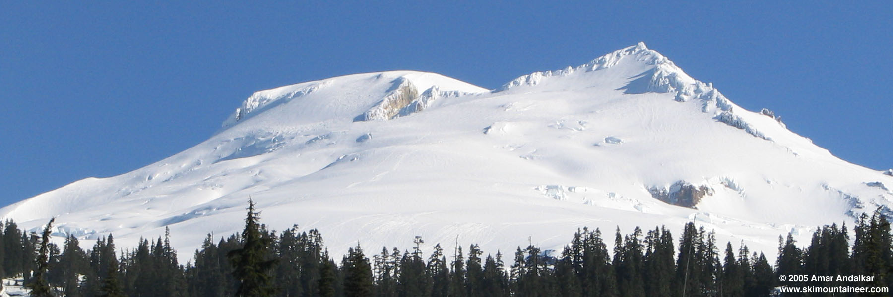
I've been asked what the current crevasse conditions are like on Mt Baker, so I might as well post a photo here if it will help others. This photo shows glacier conditions above 6500 ft on the south side (upper parts of Deming, Easton, Squak Glaciers).
It appears that on the Deming, Easton, and Squak Glaciers, crevasse conditions are more like mid-June of a typical year. The route appears to be conti...
It appears that on the Deming, Easton, and Squak Glaciers, crevasse conditions are more like mid-June of a typical year. The route appears to be conti...
Thanks Mark. I should look at cc.com more often, although any "inbreeding between web sites" would likely result in catching some horrible STD.
If that Blazer has been there since before March 22, it must have gotten buried 3-4 ft deep over the next few weeks. Although it looks partly melted out again in the second small photo attached to that thread. It's too bad it got vandalized and all his remaining stuff probably stolen.
If that Blazer has been there since before March 22, it must have gotten buried 3-4 ft deep over the next few weeks. Although it looks partly melted out again in the second small photo attached to that thread. It's too bad it got vandalized and all his remaining stuff probably stolen.
On the hike in I passed two trucks stuck and mostly buried in snow on Road 500 about half-way to the south trailhead. They won't be melting out for another couple weeks.
Thanks for the report, I'm glad it cleared up enough for you to do a moonlight ski.
Do you mean to say those trucks got stuck before the last major snowstorms buried them? How badly are they blocking the road, in case the owners don't arrive promptly to remove them as the...
Bergdorfer (or whoever) to the rescue again! Sauk is a fun little mountain, with easy road access and perfectly reasonable skiing on a variety of aspects. I like to save it for afternoon skiing during the long days of spring, since I can make it down from Bellingham in less than an hour and a half. A couple of runs down the back side to the lake and maybe one short shot southeast into the trees before dropping back down the summer trail to the road. That southwest face melts out early (it was...
A rope would be a good idea. We brought one the other day and almost whipped it out just to be sporty but decided to explore the northeast ridgeline instead. In a good year that line will completely fill in but we never actually looked at the top of it so I can't say for sure.
Zap - someone needs to buy you a digital camera.... <snip>
I second that, Zap. It's a shame not to have such great travels chronicled in pictures.
Nonetheless, I'm certainly happy for you and all your travels. What a great way to spend winter and spring. I wanna be just like you guys when I grow up!
Zap - someone needs to buy you a digital camera. I would love to compare snowpack with you. Enjoy Bishop - here's a view of Tom 4/2/05 as you hit Tom's Place: a little eye candy for you to think about on the drive south.
View from our campsite:

View from our campsite:
Zap, ZAP, this is utterly absurd!! You've been in the Sierra for like 2 months straight now -- how are you able to do this? Don't you have *some* sort of responsibity you must attend to?
It was a long tour due to the flat terrain to Lake Mary but the views and powder in Red Cone Bowl will linger a long time.The views are still stuck in my head 3 years later. If you don't mind me adding a photo to your TR, the view of the Mammoth Crest on th...
pictures!
http://spcmanspiff.users.poppinfresh.net/images/saukmtn042405/
http://spcmanspiff.users.poppinfresh.net/images/saukmtn042405/
That wind guage is on your list, buddy! Remember Heliotrope with 70mph? Plus, your rich and drive a ferrari. I am collecting photos for circumnavigation, I'll show them to you soon...
Can you get down the top part of the Col without a rope. My memory is that you can't.
Good point on Ingalls/Fortune. It looked good up high, but we didn't see the approach slopes.
We were on the late shift - we started our first run down at about 2 or so, I think.
It is indeed funny we were both there again, though it's a pretty short window for Bean if you want to drive to the TH, and we were clearly well rewarded last year, it was 30% POP east vs 70% at the crest on Sunday, and all the reports from the crest had been reporting bottomless mush, so I'm not wildly s...
Thanks for the info. I wanted to ski up there about a month ago, but the weather wasn't cooperative enough to make the drive and subsequent hike worth it.
I love my TM-EX's! On many more than one run in all types of conditions, they have performed awesomely. They handle ice, slush, powder, glop, nasty breakable windcrust, and everything else I've thrown at them. Skis that let you hit it with confidence are a definite bonus.
I love my TM-EX's! On many more than one run in all types of conditions, they have performed awesomely. They handle ice, slush, powder, glop, nasty breakable windcrust, and everything else I've thrown at them. Skis that let you hit it with confidence are a definite bonus.
I skied from Colchuck Col yesterday in surprisingly pleasant conditions. The primary objective of the trip was to climb Colchuck Peak via the N. Buttress Couloir. However, this climb would also give me a chance to baptize my new skis. At last I possess a pair that is fat enough to keep me afloat. Until this season, my backcountry skiing experience has been limited to a few trips to Muir and the Tattoosh; this year I bought some used Dynafit boots and bindings, but my skis are pretty narrow f...
. . . the sufferfest that was Sat. on the snowfield . . .
:D
When we arrived back at the Paradise lot at dusk in a driving rain on Saturday eve, Amar Andalkar's comment was, "I think I can honestly say that was the worst skiing I've ever experienced . . . "
The rumor has it that the Ingalls TH has some kind of washout or rockslide half mile shy of TH, but that's not too great a deterrent even if so. I still might go check it out soon. I'd be more concerned that a lot of the slopes on Ingalls and Fortune are relatively large talus blocks, where shallow cover might damage skier as well as ski bases, but perhaps in practice those are easy to avoid. Jim, we never saw your descent tracks; we had town commitments that meant we were out of basin at 1:30 a...
It was too bad you couldn't join us Toby...hopefully you'll make a trip real soon! We could have used your Brunton Weather Instrument (have you purchased that wind gage yet?!?!?!). VELVET is a great description of the conditions last year...perfection. The summit climb was much less intense this year...perfect pigeon holing snow. This time we went straight up to the summit ridge via a narrow snow chute...instead of veering left. Next year we should circumnavigate the summit pyramid...I'm sure yo...
Seriously ,I wish I was in the area this week I'd do this tour and take in the clustersmozzel up at Muir Snowfield.
We thought briefly about that tour as we headed eastward toward a longer trudge to snow (albeit with many avalanche lillies to see, beautiful as they mocked our timing) at Bean Creek Basin, but kept on driving. I salute you for exploring FR 9070 to discover that it is in typical early June condition! It's kind of nice to avoid the slog up the ski area and over Nordic Pass, eh?
Skip (not TAY Skip, a mere lurker) and I were also up there and saw your tracks. We were headed up the same way, but as we got partway up that snowy slope with the rocks just under the surface, we looked around to see if there was a better choice than guaranteed core shots, and decided to traverse around Bean Basin to get onto the more northerly slopes (Mary's maybe??) where we found ample cover, and got in a few laps of maybe 800-100 vf each. Those nice gullies on Earl just didn't get enough sn...
the twin lakes area is unreal!
i was there around the same time:
april 16-19
few skiers and plenty of snow.
lots of corn though the timing
was tricky on mt. walt.
we toured around twin lakes
for 3 days & tahoe for 2.
needless to say
i wannna go back!


i was there around the same time:
april 16-19
few skiers and plenty of snow.
lots of corn though the timing
was tricky on mt. walt.
we toured around twin lakes
for 3 days & tahoe for 2.
needless to say
i wannna go back!
Nice picture, I'm glad you put it up. South facing was better eh? We were a little leary of it but ended up skiing slopes just as steep.
I agree ,Cold clear nights where the snow refreezes is what we need for corn. It just won't happen without it. Idealy one should be able to boot up or even need crampons in the morning,Get on top,have a nice snack/lunch and then ski down on a sun warmed cream. linger to long and the cream turns to deep mush.in a normal season Corn conditions can last till S...
I agree ,Cold clear nights where the snow refreezes is what we need for corn. It just won't happen without it. Idealy one should be able to boot up or even need crampons in the morning,Get on top,have a nice snack/lunch and then ski down on a sun warmed cream. linger to long and the cream turns to deep mush.in a normal season Corn conditions can last till S...
Glad to hear you had a great day. I bailed out of consideration for the two of you. I knew if I came there would be no chance of sunshine...;)
Ahhh, too bad Matt, but I could have told you those would be the conditions... Last years stellar trip still enters my mind frequently....Velvet corn from top to bottom! Sounds like the Pyramid was in easier shape than last time...A little less intense?
Original plan had been to ski one of the gullies off Earl but none of these looked like they had enough cover, maybe would have gone but with a lot of base damage and rock-checks. Other than the north facing slopes we skied that are basically on the 'wrong' side of the basin (toward Ingalls Ck), the only other line that looked good that actually drained into the basin was coming off of Mary's and following a curving line into a pair of gladed tracks that ended in the upper basin flat. As we clim...
I've got to say no. Without the refreeze part of the cycle the snow from March and April is likely to wash away as meltwater and sloughs. Usually this process would begin with the first sunny warm days and cold nights of late winter/early spring. We didn't have the snow back then and now that we've got the snow, it's not cold enough at night. This year's corn harvest looks to be mighty low at least at lower elevations where the snowpack we got largely melted out by Feb.
I once made the mistake of sitting near a large congregation of ladybugs while belaying a fellow climber. I had assumed that these creatures preferred aphids and the like.
Well let me say that on bare rock, high in the mountains, they will try to eat anything, including you!
Alan
Well let me say that on bare rock, high in the mountains, they will try to eat anything, including you!
Alan
if it's clear at night, and a bit cooler, that should do the trick.
Five of us were there on Sat and found lots of mush, but quite skiable. South face of Naches was decent. We did a run o east side bowl where we found lots of sluffing on steeper rollovers, but nothing serious. 35+ slopes were showing lots of natural activity. Climbed back up for a second run down south face as it began to spit rain, then skied out to the car. We parked down from hwy junction for easey access to snow and a...
Five of us were there on Sat and found lots of mush, but quite skiable. South face of Naches was decent. We did a run o east side bowl where we found lots of sluffing on steeper rollovers, but nothing serious. 35+ slopes were showing lots of natural activity. Climbed back up for a second run down south face as it began to spit rain, then skied out to the car. We parked down from hwy junction for easey access to snow and a...
So I'm a bit new to spring skiing and the PNW (3rd summer,) and I've got a question. If we get the sunny and warm weather predicted for this week, will that be good for the consolidation of this snowpack, and turn chinook pass to better corn skiing?
And here was are, in the PNW, trying to beat the suncups to the slush. You Sierra guys are killing me, here!
Zap, I'm really enjoying your TR's. When is the book coming out? ;D
Zap, I'm really enjoying your TR's. When is the book coming out? ;D
I was up Friday afternoon to scout out a chute we had been looking at for a few years -- the only skiable chute off the Mazama Plateau between Alasken Amber
(The Upper Hourglass) and Herman Saddle. It is usually blocked by a cornice at the top, but I figured that the cornice might have softened enough to allow entry to one whose skies never leave the snow. By 6 PM I had skinned to the bottom and booted 1/3 the way up. I decided that the slope was too slushy to ski that afternoon, but it loo...
(The Upper Hourglass) and Herman Saddle. It is usually blocked by a cornice at the top, but I figured that the cornice might have softened enough to allow entry to one whose skies never leave the snow. By 6 PM I had skinned to the bottom and booted 1/3 the way up. I decided that the slope was too slushy to ski that afternoon, but it loo...
There are many good to excellent lines to ski off of Forgotten given proper coverage (bowls, chutes, tree runs). The only problem I see is that most would require hiking back up (solved by better fitness) as connecting back to the "trail" or finding a way to get back toward Perry Ck. looks to be a challenge, the final parts of any shortcuts often being blocked by cliffs and cornices.
I took my kids up there in Feb. as well and had written off lugging skis in until next year. Two...
I took my kids up there in Feb. as well and had written off lugging skis in until next year. Two...
I've lurked long enough. :)
Although I'm from California, I enjoy checking out everyone's TR and snow conditions.
Zap, enjoy your road trip.
Here's a pic of Crater Crest and Twin Peaks from about 7 weeks ago for you PNW's.


This one from two weekends ago-going up to the Twin Peaks glacier.

Although I'm from California, I enjoy checking out everyone's TR and snow conditions.
Zap, enjoy your road trip.
Here's a pic of Crater Crest and Twin Peaks from about 7 weeks ago for you PNW's.
This one from two weekends ago-going up to the Twin Peaks glacier.
I was up there in february without the skiis and very little coverage. On the traverse from the meadows we had crossed over to the west side of the ridge about halfway where there was a huge open bowl and generally open west facing slopes - I had imagined that with more coverage it would have been a good ski provided low slide danger (A nice open gully led to the base of the rock). The glades in the perry creek drainage looked like fun (good open forest structure would only take a few feet to co...
Zap, this brings me to think of the Big Thoughts that area brought me to realize. This is one of my favorite areas on the planet....Soaking in tubs, viewing your ski tracks from the tubs, thinking of tomorrows lines while pruning up in the tubs. Ahhhhh, and it's in California?? One would never know.....