TR Replies
Eldorado is a great peak, nice trip!
Fwiw, what you refer to as the "Roush Creek Snowfield" is actually glacier higher up. In the right season it is more heavily crevassed than the flat and uncrevassed upper sections of the Inspiration glacier.
Fwiw, what you refer to as the "Roush Creek Snowfield" is actually glacier higher up. In the right season it is more heavily crevassed than the flat and uncrevassed upper sections of the Inspiration glacier.
WOw! Very well written.
Thanks for being a gracious, safe, knowledgeable partner. It was a very good day.
Thanks for being a gracious, safe, knowledgeable partner. It was a very good day.
Back in the mid 70's I worked in a small bakery with a guy named Karl Ritchie who had a cabin/home on Sunland DR, just East of the White Pine road. He has long passed, I assume, unless he is in his early 100's. He used regale stories of hiking and skiing the Chiwaukum and Stevens Pass areas in the 40's. Way before there were any lifts, maybe a rope tow or T-bar at Stevens.
I was always amazed by this stout old euro with his sagging barrel chest and thick accent. His back ach...
I was always amazed by this stout old euro with his sagging barrel chest and thick accent. His back ach...
good seeing you guys out there. we ended up traversing pretty high across the talus field on the descent then just bushwhacked down to the trail from there. slow-going but could of been a lot worse.
here are some shots i got of you guys on the way up:
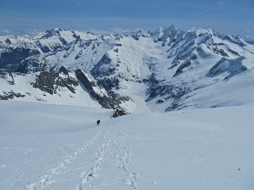
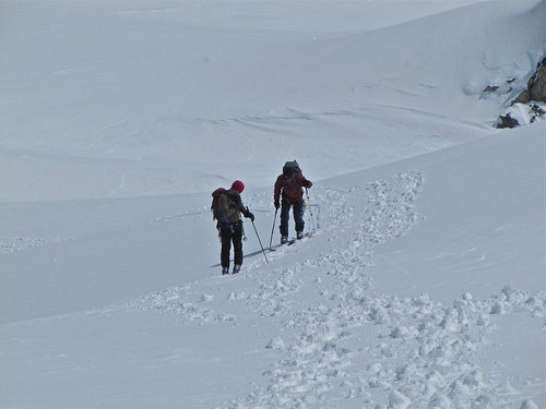

here are some shots i got of you guys on the way up:
Nice work getting out there Kyle et al. At least it is more successful than our last trip there. Too bad i couldn't join you, but warmer weather beckoned!
SkierY,
Thanks for that interesting bit of history!
Thanks for that interesting bit of history!
Nice write-up of a gnarly trip. Clearly you two are going to need to be separated...
Great day, nice to hook up with you guys again. - Russ
Cool! Man, either I gotta get my jealousy under control or Scott has to get a job. This is killing me!
Great effort but....7,000 feet is a long way to go to pull up just short of the summit???
Great effort but....7,000 feet is a long way to go to pull up just short of the summit???
Scott,
By the Grouse route being "out" do you mean the ski up via that drainage? I hope you don't mean that the crossing of the creek to the trail is out of service like a couple of years ago. I don't want to have to do that log-of-death thing again.
Any estimate of how long till the road will be clear? Probably a meaningless assessment since it was a pretty short hike for you, but if the road gets more snowfall on it it would be good to know the...
Great turns and nice to meet you all,
Doug
Doug
author=chmnyboy link=topic=16410.msg68616#msg68616 date=1271730973]
Joe, if I understand correctly, the new policy of the park is that if they don't need to plow the road, they'll leave the gate open; GaryJan might be able to clarify.
For the month of April, the road is open "As weather, road conditions and staffing permit". Hopefully this will mean continued extended open hours unless it storms. After M...
Thanks for all the comments. Joe, if I understand correctly, the new policy of the park is that if they don't need to plow the road, they'll leave the gate open; GaryJan might be able to clarify. I called the wilderness info center the day before and they clarified the road would be open all night. The winds have been strange this year, and I'm noticed certain lines filling in differently than in the past, which may explain why you didn't see it last year. That 'zelda�...
Nice trip Kyle! Thanks for the link to Oyvind's report too. I have been wondering if any TAYers have been getting to the Big Chiawaukum chutes. The route home looks to make it a classic 1 or 2 day tour! Back in the 80's and early 90's I did several weekend trips up Wildhorse creek after Stevens would close and usuallly skied both sides of Deadhorse pass. Those trips were on "toothpicks and tennis shoes" so the chutes were not even considered. ...
Yeah, when we were there late Feb. early March, we has unstable conditions. We had a storm give us ~6" just before we arrived and skied safe pockets for a week. Good fun. Nice, new, clean camp. Warm tents.
Just got back from Joffre area near Pemberton, BC. Got to watch the spring avy cycle spring into action from safe valley bottoms. Snuck out for four days.
Just got back from Joffre area near Pemberton, BC. Got to watch the spring avy cycle spring into action from safe valley bottoms. Snuck out for four days.
Hey Scott and crew. That was I on the snowmobile. I caught a photo of one of the powder clouds coming off the Colfax Icefall. The wind was sure loading it up! The Headwall above the Thunder Gl. was pretty nice powder snow, transitioning to a mixed bag near the Thunder Gl. Icefall, then corn below and down into the basin. Great corn on Marmot Ridge near the Warm Cr. chutes heading back to Grouse Ridge.
Winner winner, chicken dinner!
Don't forget your skins and backpack next time you're in Seattle.
Don't forget your skins and backpack next time you're in Seattle.
Thanks for posting the trip Don! Just looking at this picture makes the crosseyed vertigo come back.
Update 4/18. An invisible hand has placed a huge boulder 1/2 mi before TH. You can drive around it but then there is a patch of snow only a truck with very high clearance can cross, and after it brown and more snow. First couple of miles you have to alternate between skin and carry all the time (or skin on brown). I broke a pole crossing one of the avalanche swaths, pushed on for another mile, and turned back. Funny how much extra work a missing pole adds... WMD is right: staying low at creek le...
Always nice to see stuff for the Hurricane area! :)
Sounds like a good day Tyler.
Are they done locking the gate at night now? 6:00 sounds early for a gate keeper. Or do you have special privileges? 8)
That looks like a tight line on Angeles. I don't recall seeing that one when I was over there last season.
I do recall skiing what I think may be your Legend of Zelda (?) line if it the one I am thinking of. Maybe near or a bit east of where you took the shot of Mt. Angeles? There...
Thanks for sharing wmd. (I also love WMD's)
Bring back pictures next time.
Bring back pictures next time.
Good gettin guys!
Way to represent the split boarders.
Great pictures Kyle. It definately looks good up there.
So I have free-based Gu but never snorted it. Sounds straight off eight mile. ;)
Is it worth dehydrating?
Way to represent the split boarders.
Great pictures Kyle. It definately looks good up there.
So I have free-based Gu but never snorted it. Sounds straight off eight mile. ;)
Is it worth dehydrating?
Funny to think that there was bottomless pow conditions 2 weeks ago.
Nice Job Oyvind! We did Josephine that day. Looking to do Cutthroat tomorrow. Have a great day if you get out.
Thanks, WMD! I was having some misgivings about my chosen destination for tomorrow and your TR enabled me to reconsider my choices since Ruth was on my short list anyway. N
Nice job milking the Snoqualmie powder season!
"I call BS"
I got in front by accident, and then Kyle couldn't get around me. No burgers, but we did have some smoked salmon and summer sausage up top... and then snorted some dehydrated gu.
It really was an awesome route. Thanks to Kyle for doing a great job at planning this out.
From our vantage I would say the summit looked obtainable, but somewhat technical. it was corniced and getting alot of sun.
Good work. I am curious if you topped out on the actual true summit of Big C? If not what would your impression be of continuing on from where you reached your high point.
Thanks,
Eric
Thanks,
Eric
author=Joedabaker link=topic=16396.msg68519#msg68519 date=1271467336]
That is such awesome terrain up there. I spent many summers hiking as a youngster up there. Glad you got a piece of that action, always wanted to ski that prominent chute and the Swath.
I am surprised how much snow there is in the Swath with the bad season and all.
Great work!
JOe The Swath needs to be hit. Call me ;)
Amazing Kyle, great p...
That is such awesome terrain up there. I spent many summers hiking as a youngster up there. Glad you got a piece of that action, always wanted to ski that prominent chute and the Swath.
I am surprised how much snow there is in the Swath with the bad season and all.
Great work!
I am surprised how much snow there is in the Swath with the bad season and all.
Great work!
Cool pics and nice one guys! Although I do call BS on your comment, "Scott took the lead..." booting up the couloir, unless there were smoked burgers waiting for him at the top.
Thanks Andy ,that's helpful. We need some cold nights.
wow! amazing helmut cam on the ridge! looks like a big drop skiers right.
Very well done! Kick-ass fantastic. I've always wanted to snowboard up there. Incredible terrain with a trailhead within 30 minutes of my house.
Dude, nice pics and way to nail it you guys! Great pics Kyle! Did you guys eat some delicious breakfast sandwiches to help you on your way? ;)
Way to get it out E. Looks like you're fighting some thin cover!
Looks like the sledders were working on the sidehill, digging out a bit to get past the debris.
author=Darryl link=topic=16359.msg68417#msg68417 date=1271282147]
Not only does she win rando races, she skis with a cat on her back!
and not only that, but she should have been the Lange girl too. Still think it's a crime that she didn't win....
Cool trip, I was wondering about that last week.
From your pics, it looks like you hit it about right, anymore snow and the approach is long. We did it about 8 years ago mid winter with very low snow elevation and the approach was tough, but well worth it.
From your pics, it looks like you hit it about right, anymore snow and the approach is long. We did it about 8 years ago mid winter with very low snow elevation and the approach was tough, but well worth it.
author=CookieMonster link=topic=16323.msg68303#msg68303 date=1271134497]
I'm not trying to be snarky, but CascadeClimber made these posts with the convenience of hindsight. This doesn't make him look smart or experienced ... it makes him look awfully sanctimonius.
This is your assumption. I'd be willing to bet CC didn't just read a Seattle Times article and think it was dangerous out there. A 5 year...
like the ridge ski with the sun....it was great with the music!
MY personel rule of thumb.
DO the the trees run all the way up to the ridge line? Is there a starting zone above the trees?
I'm of the opinion that the ups and downs of temperature of our marine climate causes tree bombs which in turn helps stabilize stands of old growth. All bets are off if there has been sustained deep cold or heavy rain .
The issue is not the trees but how they relate to the terrain. You can ski to Pineapple Basin and trigger small avalanches in the trees that have nowhere to go because of the configuration of the slope. Are the trees below a large path, above an unsupported slope of out in the middle or a bowl? Context will inform you how safe the tree skiing is.
The accidents occurred near or in actual avalanche paths, so does that make the trees a poor choice? That depends on how the terrain relates...
The accidents occurred near or in actual avalanche paths, so does that make the trees a poor choice? That depends on how the terrain relates...