- Posts: 635
- Thank you received: 0
HUGE storm cycle brings 4-14 ft snow Feb6-25,2014!
- Amar Andalkar
-
 Topic Author
- User
-

Less
More
12 years 2 months ago - 12 years 1 month ago #220185
by Amar Andalkar
HUGE storm cycle brings 4-14 ft snow Feb6-25,2014! was created by Amar Andalkar
[size=small]Note: Original thread title: Next major storm to bring 4-6 ft snow this week!
Title edited on 02/07/14 to include dates: Next major storm brings 4-6 ft snow Feb 6-14,2014!
Title updated on 02/14/14 to better reflect how this storm cycle has evolved: HUGE storm cycle brings 4-12 ft snow Feb6-21,2014!
Title updated on 02/21/14 to reflect unexpected continuation of this storm cycle: HUGE storm cycle brings 4-14 ft snow Feb6-25,2014![/size]
[hr]
Next major storm cycle to bring 4-6 ft of snow over the next week, primarily to Oregon and northern California, with 3-4 ft in Washington!
See also earlier threads:
First major storm cycle of the 2013-14 season brings 4-8 ft of snow (January 7-14, 2014)
Another major storm cycle brings 2-5 ft of snow this week (January 28-February 1, 2014)
During the past few days, weather models have started predicting another major change in the weather pattern over the West Coast during the rest of this week and throughout much of next week, to what appears to be a sustained period of typical wintertime weather: a series of storm systems driven by strong westerly flow over the North Pacific. The anomalously strong and persistent ridge of high pressure which has lingered just off the West Coast for much of the last 4 months is no longer a factor as of now, having retreated far to the south where it typically lies during the winter months. Model predictions were varying somewhat the past few days, but subsequent runs now appear to be trending towards greater precip and snowfall amounts, so the predicted large snowfall totals are more likely to actually occur.
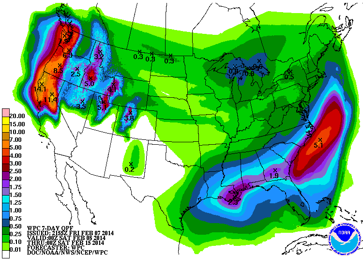
The NWS's GFS model and their Quantitative Precipitation Forecasts are showing up to 8-12" of precip over the next week for the mountains of Oregon and northern California, with 3-4" extending north through Washington. Here is total precipitation in inches predicted over the next 7 days through the afternoon of February 13:
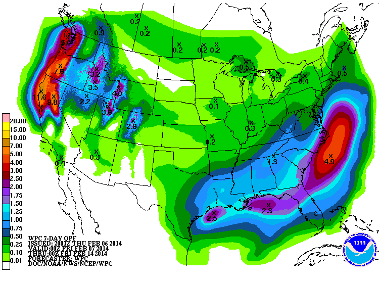
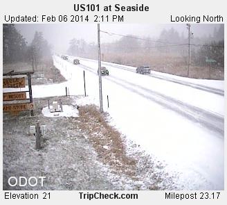
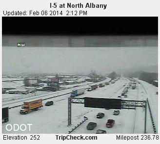
If those predictions verify, it would be by far the wettest storm cycle of this entire winter in southern Oregon and California. The first system in the storm cycle has already moved ashore into Oregon and northern California earlier this morning (February 6), with several inches of snow down to near sea level for parts of the Oregon Coast and the Willamette Valley due to the cold air already in place:
The high-resolution UW WRF-GFS model is showing total snowfall amounts up to 4-6 ft or more over the next week for the mountains of Oregon and northern California, with 3-4 ft in Washington. Snowfall during the first 3 days of the storm cycle through 4am Sunday is predicted to be 3-6 ft over the volcanic peaks of the southern Oregon Cascades and California Cascades, plus much of the Sierra Nevada as far south as Mammoth Mountain, and also most of the Wasatch Range in Utah:
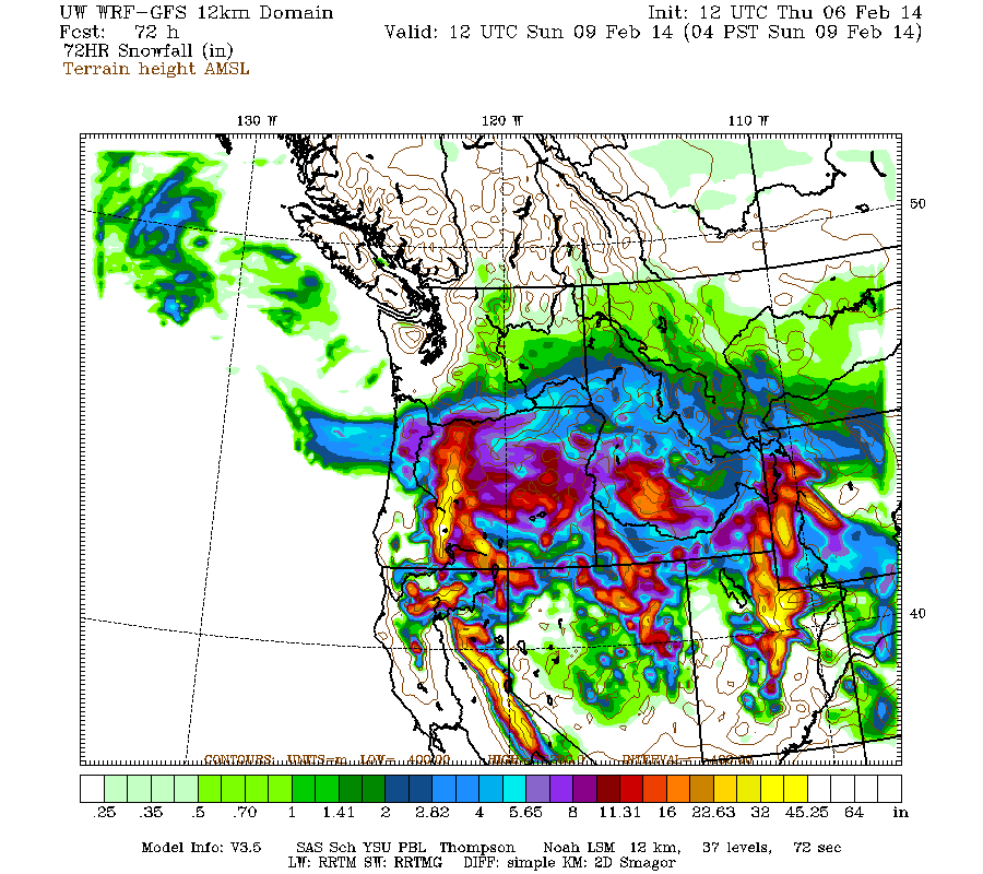
Higher resolution version of that, showing the Pacific Northwest and also zoomed in on Oregon:
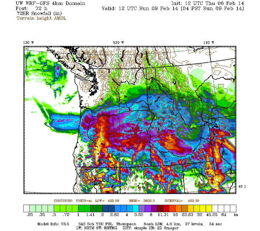
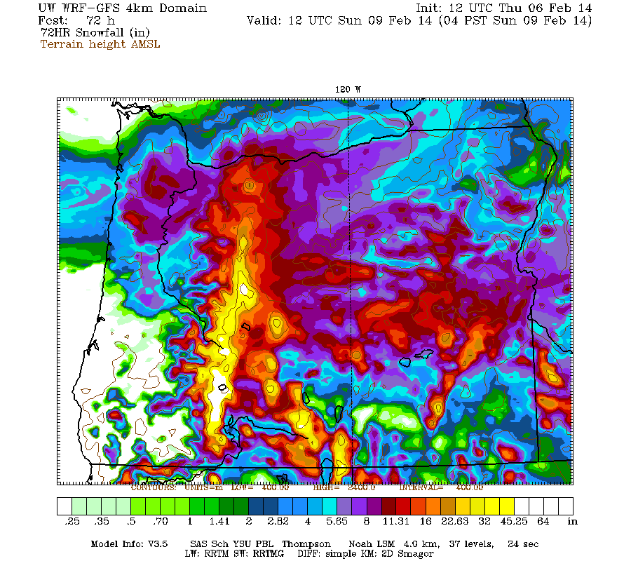
Maximum amounts of 4-6 ft (marked by white inside yellow) are shown in the Three Sisters region and much of the Cascade Crest from Willamette Pass south past Crater Lake, along with Mount Shasta and Lassen Peak in California.
The snowpack situation in southern Oregon is grim: Crater Lake is normally one of the snowiest locations in Oregon with over 520" of average annual snowfall at Park Headquarters (6470 ft), but as of today it has received only 75" this winter (26% of the normal of 296" by this date), while snowdepth is only 17" (18% of the normal depth of 95" on this date). The February 1 snowdepth of 15" was an all-time record low for the date (previous low was 16" in February 1977) and only 16% of the normal depth of 94", with records extending back to 1920.
Yet the situation is FAR WORSE on Mount Shasta, where there is ZERO snowpack at both the Sand Flat (6800 ft) and Horse Camp (7900 ft) monthly snow course sites as of the February 1 snow survey (measured on January 30 this year) -- easily an all-time record low for the date, the previous lowest amounts were 11" and 13" at the two sites in the February 1991 survey. The normal February 1 snowdepths are 74" at Sand Flat and 89" at Horse Camp, with records extending back to 1945 and 1930 respectively. The Old Ski Bowl telemetry site at 7600 ft on the south side of Shasta may have about 4" on the ground now, while its normal depth is about 90". On Lassen Peak, the snow course at 8250 ft near Lake Helen (by far the snowiest measurement site in California, with normal snowdepths roughly equal to Mount Rainier Paradise and Mount Baker Ski Area) has only 12" as of the January 28 survey, also a record low at only 10% of the normal of 122" (period of record back to 1930) and half the previous low of 24" in the February 1977 survey. These areas need 4-6 ft of new snowfall very badly, probably more than anyplace else in the world!
This loop shows how the model predictions for snowfall during the 3-day period through 4am Sunday have evolved between 10 subsequent runs over the last 5 days, known in the jargon as D(model)/D(t). Lots of major changes in everything during the early model runs several days ago, but then settling into a fairly consistent picture over the last 4 runs during the past 2 days:
www.atmos.washington.edu/~ovens/wxloop.c...2+v2014020912///+-st
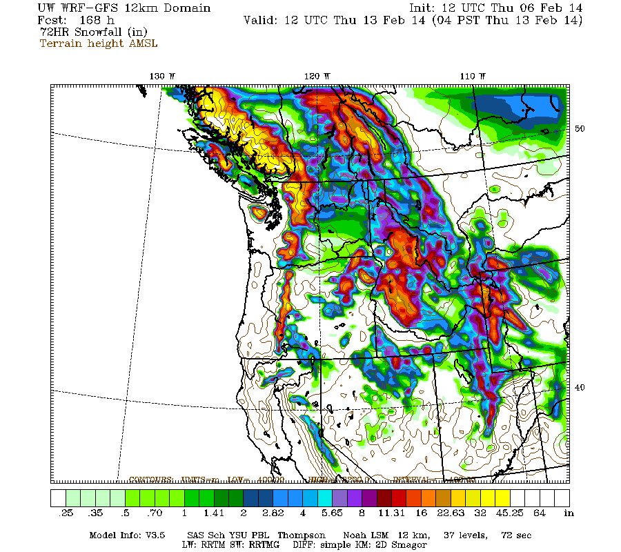
There is a minor lull between systems predicted for Sunday, then the next system in the cycle is expected to move ashore into Monday, this time aiming farther north towards northern Oregon, Washington, and southwestern British Columbia. Snowfall during the 4-7 day period, the 3 days ending 4am next Thursday, is predicted to be 3-4 ft over the west slopes and volcanic peaks of the Washington and northern Oregon Cascades, with 3-5 ft in southwestern BC.
Title edited on 02/07/14 to include dates: Next major storm brings 4-6 ft snow Feb 6-14,2014!
Title updated on 02/14/14 to better reflect how this storm cycle has evolved: HUGE storm cycle brings 4-12 ft snow Feb6-21,2014!
Title updated on 02/21/14 to reflect unexpected continuation of this storm cycle: HUGE storm cycle brings 4-14 ft snow Feb6-25,2014![/size]
[hr]
Next major storm cycle to bring 4-6 ft of snow over the next week, primarily to Oregon and northern California, with 3-4 ft in Washington!
See also earlier threads:
First major storm cycle of the 2013-14 season brings 4-8 ft of snow (January 7-14, 2014)
Another major storm cycle brings 2-5 ft of snow this week (January 28-February 1, 2014)
During the past few days, weather models have started predicting another major change in the weather pattern over the West Coast during the rest of this week and throughout much of next week, to what appears to be a sustained period of typical wintertime weather: a series of storm systems driven by strong westerly flow over the North Pacific. The anomalously strong and persistent ridge of high pressure which has lingered just off the West Coast for much of the last 4 months is no longer a factor as of now, having retreated far to the south where it typically lies during the winter months. Model predictions were varying somewhat the past few days, but subsequent runs now appear to be trending towards greater precip and snowfall amounts, so the predicted large snowfall totals are more likely to actually occur.
The NWS's GFS model and their Quantitative Precipitation Forecasts are showing up to 8-12" of precip over the next week for the mountains of Oregon and northern California, with 3-4" extending north through Washington. Here is total precipitation in inches predicted over the next 7 days through the afternoon of February 13:
If those predictions verify, it would be by far the wettest storm cycle of this entire winter in southern Oregon and California. The first system in the storm cycle has already moved ashore into Oregon and northern California earlier this morning (February 6), with several inches of snow down to near sea level for parts of the Oregon Coast and the Willamette Valley due to the cold air already in place:
The high-resolution UW WRF-GFS model is showing total snowfall amounts up to 4-6 ft or more over the next week for the mountains of Oregon and northern California, with 3-4 ft in Washington. Snowfall during the first 3 days of the storm cycle through 4am Sunday is predicted to be 3-6 ft over the volcanic peaks of the southern Oregon Cascades and California Cascades, plus much of the Sierra Nevada as far south as Mammoth Mountain, and also most of the Wasatch Range in Utah:
Higher resolution version of that, showing the Pacific Northwest and also zoomed in on Oregon:
Maximum amounts of 4-6 ft (marked by white inside yellow) are shown in the Three Sisters region and much of the Cascade Crest from Willamette Pass south past Crater Lake, along with Mount Shasta and Lassen Peak in California.
The snowpack situation in southern Oregon is grim: Crater Lake is normally one of the snowiest locations in Oregon with over 520" of average annual snowfall at Park Headquarters (6470 ft), but as of today it has received only 75" this winter (26% of the normal of 296" by this date), while snowdepth is only 17" (18% of the normal depth of 95" on this date). The February 1 snowdepth of 15" was an all-time record low for the date (previous low was 16" in February 1977) and only 16% of the normal depth of 94", with records extending back to 1920.
Yet the situation is FAR WORSE on Mount Shasta, where there is ZERO snowpack at both the Sand Flat (6800 ft) and Horse Camp (7900 ft) monthly snow course sites as of the February 1 snow survey (measured on January 30 this year) -- easily an all-time record low for the date, the previous lowest amounts were 11" and 13" at the two sites in the February 1991 survey. The normal February 1 snowdepths are 74" at Sand Flat and 89" at Horse Camp, with records extending back to 1945 and 1930 respectively. The Old Ski Bowl telemetry site at 7600 ft on the south side of Shasta may have about 4" on the ground now, while its normal depth is about 90". On Lassen Peak, the snow course at 8250 ft near Lake Helen (by far the snowiest measurement site in California, with normal snowdepths roughly equal to Mount Rainier Paradise and Mount Baker Ski Area) has only 12" as of the January 28 survey, also a record low at only 10% of the normal of 122" (period of record back to 1930) and half the previous low of 24" in the February 1977 survey. These areas need 4-6 ft of new snowfall very badly, probably more than anyplace else in the world!
This loop shows how the model predictions for snowfall during the 3-day period through 4am Sunday have evolved between 10 subsequent runs over the last 5 days, known in the jargon as D(model)/D(t). Lots of major changes in everything during the early model runs several days ago, but then settling into a fairly consistent picture over the last 4 runs during the past 2 days:
www.atmos.washington.edu/~ovens/wxloop.c...2+v2014020912///+-st
There is a minor lull between systems predicted for Sunday, then the next system in the cycle is expected to move ashore into Monday, this time aiming farther north towards northern Oregon, Washington, and southwestern British Columbia. Snowfall during the 4-7 day period, the 3 days ending 4am next Thursday, is predicted to be 3-4 ft over the west slopes and volcanic peaks of the Washington and northern Oregon Cascades, with 3-5 ft in southwestern BC.
Please Log in or Create an account to join the conversation.
- bwalt822
-
- User
-
Less
More
- Posts: 48
- Thank you received: 0
12 years 2 months ago #220187
by bwalt822
Replied by bwalt822 on topic Re: Next major storm to bring 4-6 ft snow this week!
I really like these analyses, may I suggest putting the dates of the storm in the title of the thread similar to your links above? It will make it easier to distinguish them and to go back to them later. I.e. Next major storm to bring X to Y ft of snow Feb 9-13!
Please Log in or Create an account to join the conversation.
- flowing alpy
-
- User
-
Less
More
- Posts: 1272
- Thank you received: 0
12 years 2 months ago #220188
by flowing alpy
Replied by flowing alpy on topic Re: Next major storm to bring 4-6 ft snow this week!
pretty pics amar.
b
b
Please Log in or Create an account to join the conversation.
- Pete A
-
- User
-
Less
More
- Posts: 431
- Thank you received: 0
12 years 2 months ago #220189
by Pete A
Replied by Pete A on topic Re: Next major storm to bring 4-6 ft snow this week!
yeah! Amar the weather oracle brings good news ")
Please Log in or Create an account to join the conversation.
- Amar Andalkar
-
Topic Author
- User
-
Less
More
- Posts: 635
- Thank you received: 0
12 years 2 months ago - 12 years 2 months ago #220190
by Amar Andalkar
Thanks, that's a good suggestion, although hard to implement within the TAY software's overly restrictive 50-character limit on topic titles. Especially when writing trip reports, I've so often wished that the limit were about 80 characters instead, which would give much more freedom and flexibility in titling posts. Anyway, I've taken your suggestion and edited the titles of all three threads to include the date as best possible within the limit. It would be nice to include the year also, but there appears to be no way to do so for some of the threads without removing important words from the title -- I re-edited this thread's title to do so.
Update #1 to be posted shortly, later today.
Replied by Amar Andalkar on topic Re: Next major storm to bring 4-6 ft of snow Feb 6-13!
I really like these analyses, may I suggest putting the dates of the storm in the title of the thread similar to your links above? It will make it easier to distinguish them and to go back to them later. I.e. Next major storm to bring X to Y ft of snow Feb 9-13!
Thanks, that's a good suggestion, although hard to implement within the TAY software's overly restrictive 50-character limit on topic titles. Especially when writing trip reports, I've so often wished that the limit were about 80 characters instead, which would give much more freedom and flexibility in titling posts. Anyway, I've taken your suggestion and edited the titles of all three threads to include the date as best possible within the limit. It would be nice to include the year also, but there appears to be no way to do so for some of the threads without removing important words from the title -- I re-edited this thread's title to do so.
Update #1 to be posted shortly, later today.
Please Log in or Create an account to join the conversation.
- Amar Andalkar
-
Topic Author
- User
-
Less
More
- Posts: 635
- Thank you received: 0
12 years 2 months ago - 12 years 2 months ago #220191
by Amar Andalkar
Replied by Amar Andalkar on topic Re: Next major storm brings 4-6 ft snow Feb 6-14,2014!
Update: 24 hours later, models are still predicting 4-6 ft of snow over the next week for Oregon and northern California, but also now for Washington!
A day later, and 2 subsequent runs of the UW WRF-GFS model at 12-hour intervals continue to predict large snowfall amounts. The predicted amounts for both precip and snowfall have actually increased significantly, for both northern California and Oregon during the first part of the storm cycle over the next 2-3 days through Sunday, and for Washington during the second part over the subsequent 5 days through Friday, February 14.
The NWS's GFS model and their Quantitative Precipitation Forecasts are now showing up to 10-14" of precip over the next week for the mountains of northern California, with 6-8" in Oregon and even into Washington now. Here is total precipitation in inches predicted over the next 7 days through the afternoon of February 14:
As of Friday morning, February 7, up to 4-12" of new snow has already fallen since the storm cycle began 24 hours earlier, throughout the Oregon Cascades and into Washington as far north as Mount Rainier, even including many areas in the foothills and lowlands due to the cold air already in place. Up to 4-8" has also fallen in the California Cascades and the northern Sierra Nevada as far south as Mammoth Mountain.
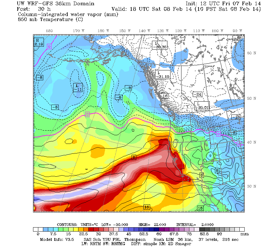
The next part of this storm cycle is actually a major atmospheric river event, a "Pineapple Express" aimed at northern California. These type of events during wintertime provide the majority of California's annual precipitation, and 10-14" of precip will make a significant improvement to the currently unprecedented drought situation in northern California. This image shows the predicted plume of moisture streaming out of the subtropics near Hawaii towards northern California as of Saturday morning:
The current water vapor satellite image (see www.nrlmry.navy.mil/sat-bin/epac_westcoast.cgi ) shows the plume already forming as of Friday afternoon:

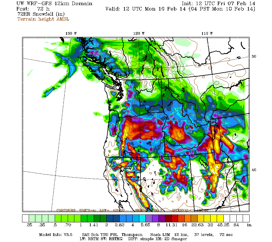
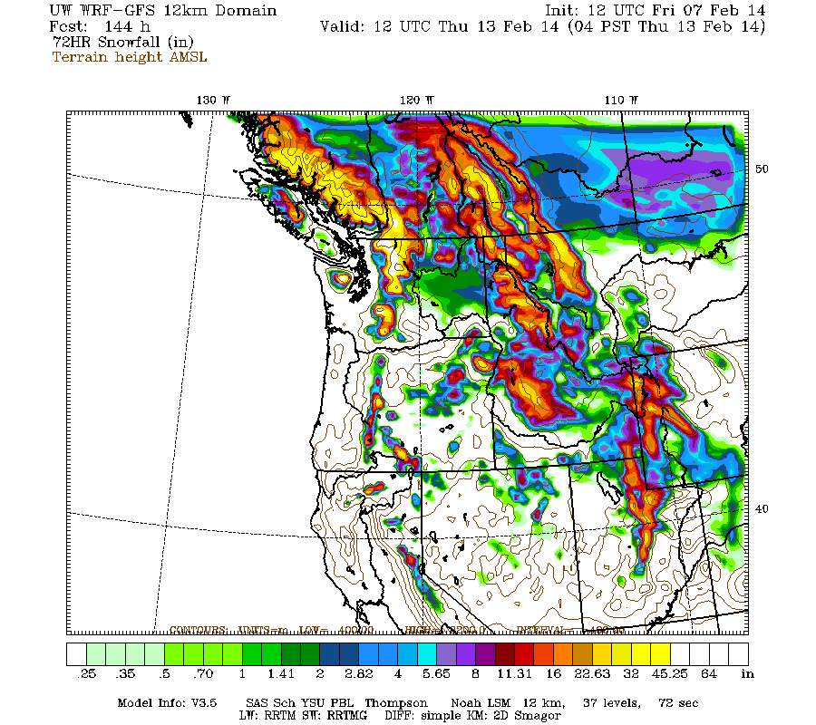
Very heavy precipitation and snowfall above 4-5000 ft will begin overnight into Saturday morning for northern California and southern Oregon, and continue through Sunday, with snow levels rising by late Saturday to 6000 ft in southern Oregon and northernmost California, and 8000 ft farther south near Lake Tahoe. Additional snowfall during the next 3 days through 4am Monday is predicted to be 3-6 ft over the volcanic peaks of the southern Oregon Cascades and California Cascades, plus much of the Sierra Nevada as far south as Mammoth Mountain, and also most of the Wasatch Range in Utah:
Higher resolution version of that, showing the Pacific Northwest and also zoomed in on Oregon:
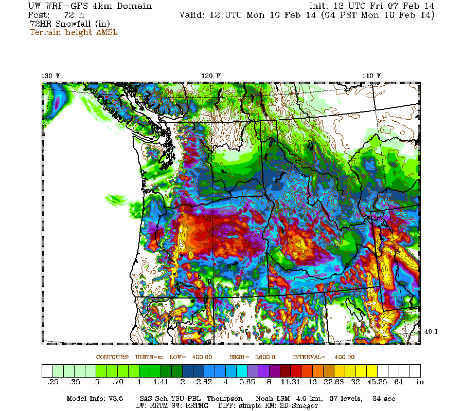
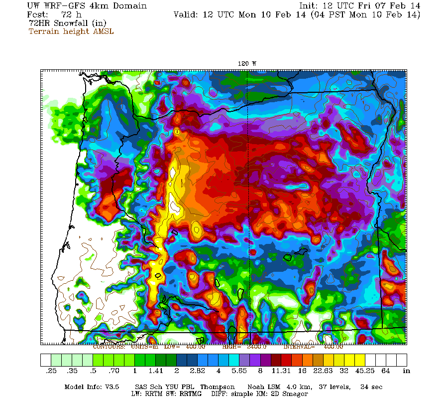
Maximum amounts of 4-6 ft (marked by white inside yellow) are shown on Mount Jefferson, the Three Sisters region, and parts of the Cascade Crest from Willamette Pass south past Crater Lake, along with Mount Shasta and Lassen Peak in California.
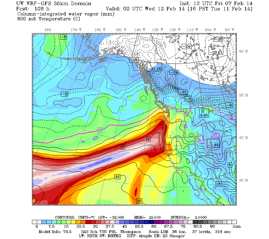
There is still a minor lull between systems predicted for late Sunday, then the next system in the cycle is expected to move ashore into Monday, this time aiming farther north towards northern Oregon, Washington, and southwestern British Columbia. The next much stronger system comes ashore in the same region Monday night into Tuesday, evolving into another atmospheric river event by Tuesday afternoon, aimed a few hundred miles farther north than the first. This image shows the predicted plume of moisture streaming out of the subtropics near Hawaii towards Oregon as of Tuesday afternoon:
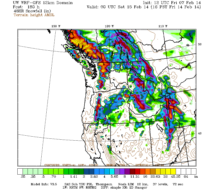
Snowfall during the 3-6 day period, the 3 days ending 4am next Thursday, is predicted to be 3-5 ft over the west slopes and volcanic peaks of the Washington and northern Oregon Cascades, the Olympics, and southwestern BC.
Beyond that point, it appears that this storm cycle is likely to continue to bring additional systems ashore every 1-2 days, producing continued precip and heavy snowfall through next week. There is another partial lull on Wednesday, then the next system may arrive on Thursday. Additional snowfall during the 2 day period ending 4pm next Friday is predicted to be 2-3 ft over the west slopes and volcanic peaks of the Washington and Oregon Cascades plus southwestern BC.
Details may certainly change as that period draws closer, as it is currently 5-7 days out, near the limit of accurate numerical weather prediction.
A day later, and 2 subsequent runs of the UW WRF-GFS model at 12-hour intervals continue to predict large snowfall amounts. The predicted amounts for both precip and snowfall have actually increased significantly, for both northern California and Oregon during the first part of the storm cycle over the next 2-3 days through Sunday, and for Washington during the second part over the subsequent 5 days through Friday, February 14.
The NWS's GFS model and their Quantitative Precipitation Forecasts are now showing up to 10-14" of precip over the next week for the mountains of northern California, with 6-8" in Oregon and even into Washington now. Here is total precipitation in inches predicted over the next 7 days through the afternoon of February 14:
As of Friday morning, February 7, up to 4-12" of new snow has already fallen since the storm cycle began 24 hours earlier, throughout the Oregon Cascades and into Washington as far north as Mount Rainier, even including many areas in the foothills and lowlands due to the cold air already in place. Up to 4-8" has also fallen in the California Cascades and the northern Sierra Nevada as far south as Mammoth Mountain.
The next part of this storm cycle is actually a major atmospheric river event, a "Pineapple Express" aimed at northern California. These type of events during wintertime provide the majority of California's annual precipitation, and 10-14" of precip will make a significant improvement to the currently unprecedented drought situation in northern California. This image shows the predicted plume of moisture streaming out of the subtropics near Hawaii towards northern California as of Saturday morning:
The current water vapor satellite image (see www.nrlmry.navy.mil/sat-bin/epac_westcoast.cgi ) shows the plume already forming as of Friday afternoon:
Very heavy precipitation and snowfall above 4-5000 ft will begin overnight into Saturday morning for northern California and southern Oregon, and continue through Sunday, with snow levels rising by late Saturday to 6000 ft in southern Oregon and northernmost California, and 8000 ft farther south near Lake Tahoe. Additional snowfall during the next 3 days through 4am Monday is predicted to be 3-6 ft over the volcanic peaks of the southern Oregon Cascades and California Cascades, plus much of the Sierra Nevada as far south as Mammoth Mountain, and also most of the Wasatch Range in Utah:
Higher resolution version of that, showing the Pacific Northwest and also zoomed in on Oregon:
Maximum amounts of 4-6 ft (marked by white inside yellow) are shown on Mount Jefferson, the Three Sisters region, and parts of the Cascade Crest from Willamette Pass south past Crater Lake, along with Mount Shasta and Lassen Peak in California.
There is still a minor lull between systems predicted for late Sunday, then the next system in the cycle is expected to move ashore into Monday, this time aiming farther north towards northern Oregon, Washington, and southwestern British Columbia. The next much stronger system comes ashore in the same region Monday night into Tuesday, evolving into another atmospheric river event by Tuesday afternoon, aimed a few hundred miles farther north than the first. This image shows the predicted plume of moisture streaming out of the subtropics near Hawaii towards Oregon as of Tuesday afternoon:
Snowfall during the 3-6 day period, the 3 days ending 4am next Thursday, is predicted to be 3-5 ft over the west slopes and volcanic peaks of the Washington and northern Oregon Cascades, the Olympics, and southwestern BC.
Beyond that point, it appears that this storm cycle is likely to continue to bring additional systems ashore every 1-2 days, producing continued precip and heavy snowfall through next week. There is another partial lull on Wednesday, then the next system may arrive on Thursday. Additional snowfall during the 2 day period ending 4pm next Friday is predicted to be 2-3 ft over the west slopes and volcanic peaks of the Washington and Oregon Cascades plus southwestern BC.
Details may certainly change as that period draws closer, as it is currently 5-7 days out, near the limit of accurate numerical weather prediction.
Please Log in or Create an account to join the conversation.