- Posts: 165
- Thank you received: 1
HUGE storm cycle brings 4-14 ft snow Feb6-25,2014!
- JPH
-

- User
-

Less
More
12 years 1 month ago #220662
by JPH
It's called meteorological reverse psychology.....and it worked!
Replied by JPH on topic Re: HUGE storm cycle brings 4-12 ft snow Feb6-21,2014!
I really do love it when all the gloom-and-doom whiners, those complaining about how bad the early-season snowpack is and how that means the season will be a total bust, turn out to be utterly and completely wrong.
It's called meteorological reverse psychology.....and it worked!
Please Log in or Create an account to join the conversation.
- Jason4
-
- User
-
Less
More
- Posts: 178
- Thank you received: 0
12 years 1 month ago #220664
by Jason4
I very much appreciate the info and detail that you take so much time to prepare and share with us but I think we have very different ideas of what "the entire winter" is. I don't see how the incredible second half of February makes all of November, December, and January any better than it already was.
I am very happy that this big dump will save our spring skiing and am looking forward to checking out the condition the glaciers are in close to home. I'm also happy that some of the lower elevation approaches are less bushwacky.
Thanks again for all the share analysis.
Replied by Jason4 on topic Re: HUGE storm cycle brings 4-12 ft snow Feb6-21,2014!
I really do love it when all the gloom-and-doom whiners, those complaining about how bad the early-season snowpack is and how that means the season will be a total bust, turn out to be utterly and completely wrong. At least in Washington, northern Oregon, and southwestern BC, it appears certain that they will be wrong very shortly, and the entire season will be saved and set to go, with a substantial snowpack deep enough to last through spring as usual.
I very much appreciate the info and detail that you take so much time to prepare and share with us but I think we have very different ideas of what "the entire winter" is. I don't see how the incredible second half of February makes all of November, December, and January any better than it already was.
I am very happy that this big dump will save our spring skiing and am looking forward to checking out the condition the glaciers are in close to home. I'm also happy that some of the lower elevation approaches are less bushwacky.
Thanks again for all the share analysis.
Please Log in or Create an account to join the conversation.
- Amar Andalkar
-
Topic Author
- User
-
Less
More
- Posts: 635
- Thank you received: 0
12 years 1 month ago #220665
by Amar Andalkar
Replied by Amar Andalkar on topic Re: HUGE storm cycle brings 4-14 ft snow Feb6-25,2014!
Update #13: 360 hours (15 days) after initial post, 2-12 ft of snow has already fallen along the coast from Alaska to California,
with an additional 1-3 ft predicted through Tuesday including the possibility of lowland snowfall in western Washington!
The final stage of this lengthy storm cycle has arrived, following the most intense period of snowfall thus far in the 2013-14 season in the Pacific Northwest over the past 6 days, with several feet of new powder at lowering snow levels! The last systems of this storm cycle are expected to come over the weekend and into the start of next week, providing a final burst of snowfall for Washington and northern Oregon over the weekend into Tuesday.
Another day later, and 2 more subsequent runs of the UW WRF-GFS model at 12-hour intervals continue to predict a surprising conclusion to this storm cycle: TWO MORE shots of snow over the weekend into next week, including a significant chance of lowland snowfall in western Washington both times. The TV news has quickly latched onto this possibility, and panic may be about to set in once again in this region.
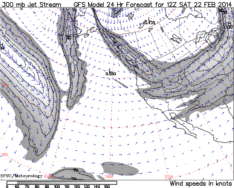
The jet stream (see Days 1-5 Jet Stream Analysis & Forecasts ) is still the key to what is likely to happen. By Saturday, the tail end of the strong jet stream which brought so much snowfall this week will have shifted eastward over the BC coast and be coming in from the north-northwest directly over Washington state, bringing the first shot of snow down from that direction (compare with the same image in Update #11 above, this image is almost identical to the prediction 3 days earlier):
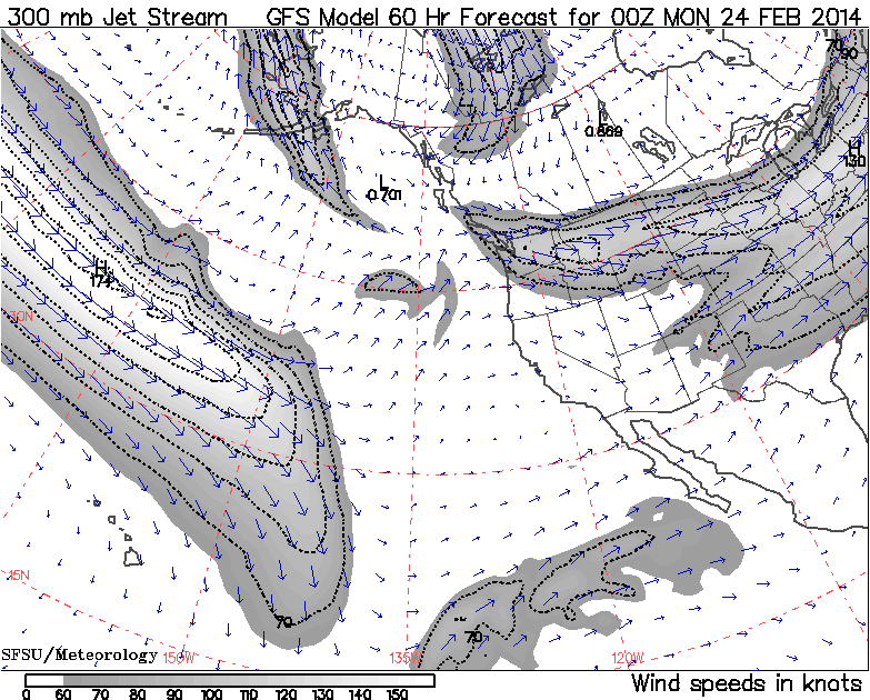
By late Sunday and into Monday, the jet stream pattern will have evolved and shifted south and east over the central part of the continent, with only the entrance region of the jet over the Northwest, allowing another system to develop in that region and entrain some moisture from the southwest, providing a second shot at snow at that time:
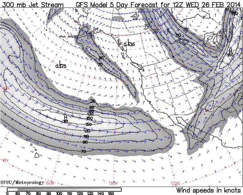
By Wednesday, that jet has departed, this storm cycle is long over, and a new jet is about to land in California, where jets bearing large quantities of moisture are currently most welcome to land:
This large animated GIF image (47 frames like the image above, 2.6 MB) shows the entire evolution of the jet stream during this storm cycle at 12-hour intervals, from February 3 a few days before it started through today, plus predictions for the next 5 days through Wednesday, February 26. I think it's a fascinating way to watch how this entire complicated storm cycle originated and then played out:
www.skimountaineer.com/TR/Images2014/jetstream_pac-Feb2014.gif
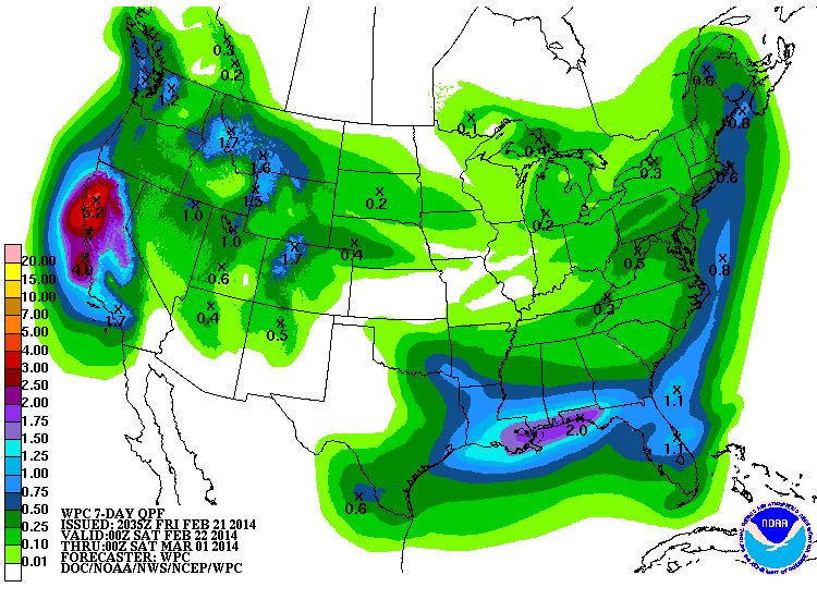
The NWS's GFS model and their Quantitative Precipitation Forecasts are now showing up to 4-5" of precip in California from that new storm cycle next week, which is great news for that severely drought-stricken region. Here is total precipitation in inches predicted over the next 7 days through Friday afternoon, February 28, with almost all of that shown in the Pacific Northwest falling in the next 3+ days though Monday in Washington and early Tuesday in Oregon, and all of that in California during the 5-7 day period from Wednesday onward:
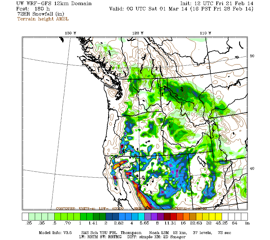
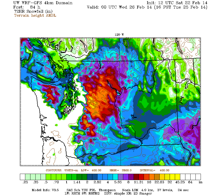
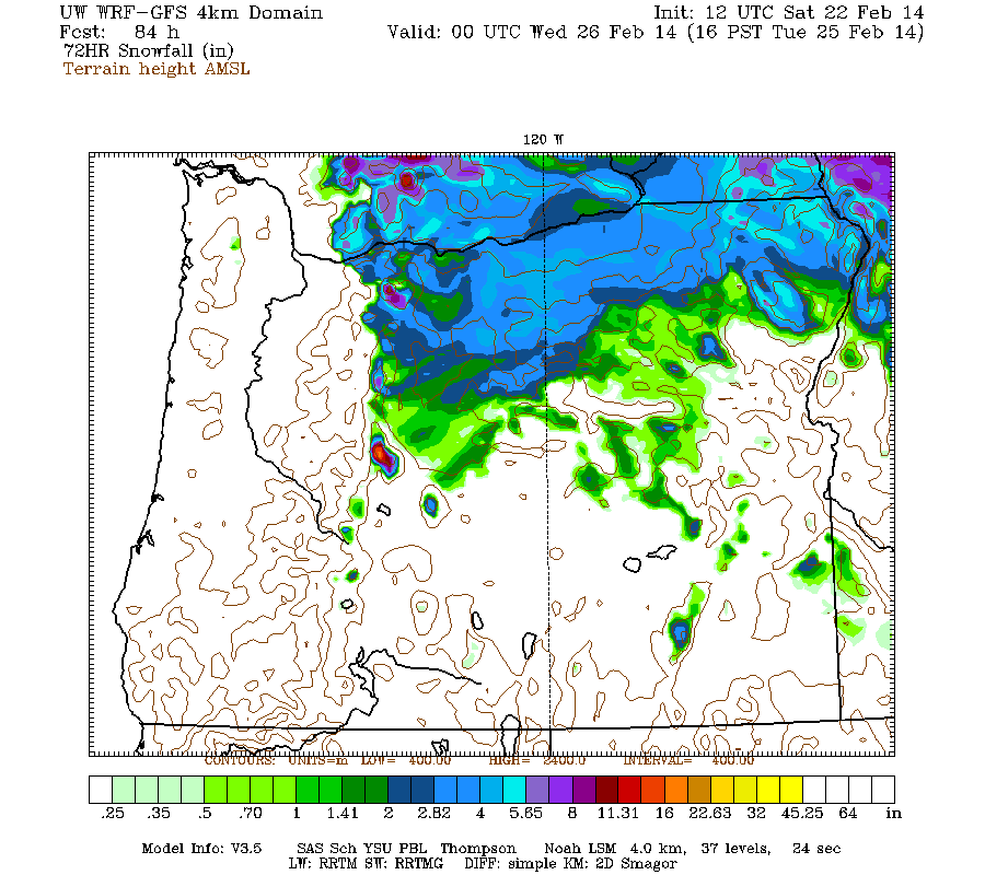
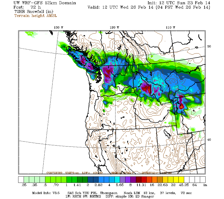
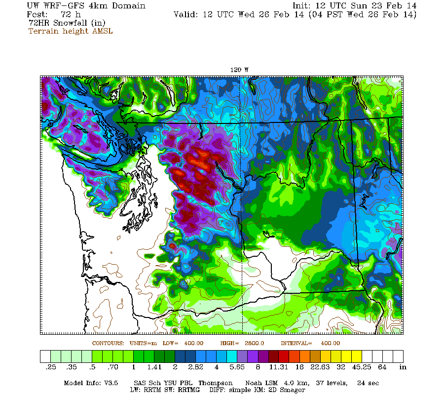
Snowfall during the next 3 days through 4pm Monday (which catches all but the tail end of the weekend systems) is predicted to be about 1 ft over most of the Washington Cascades and Olympics (more like 1-3 ft in the central Cascades and Mount Rainier), with several inches over southwestern BC and the northern Oregon Cascades:
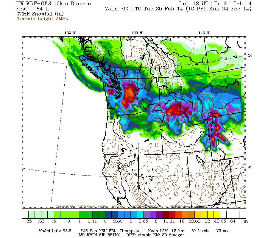
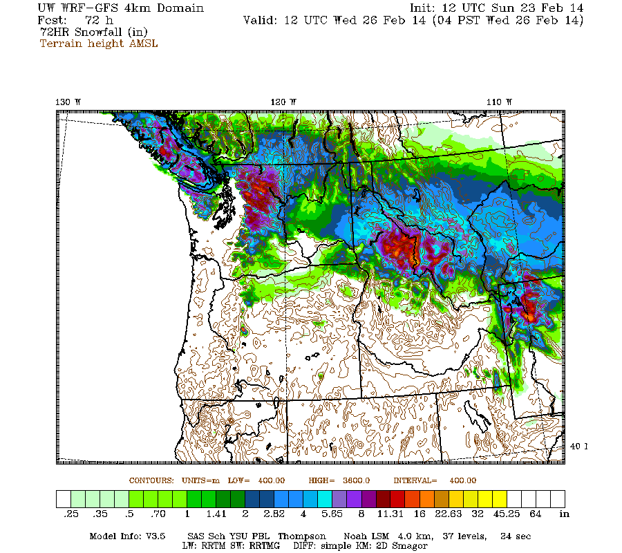
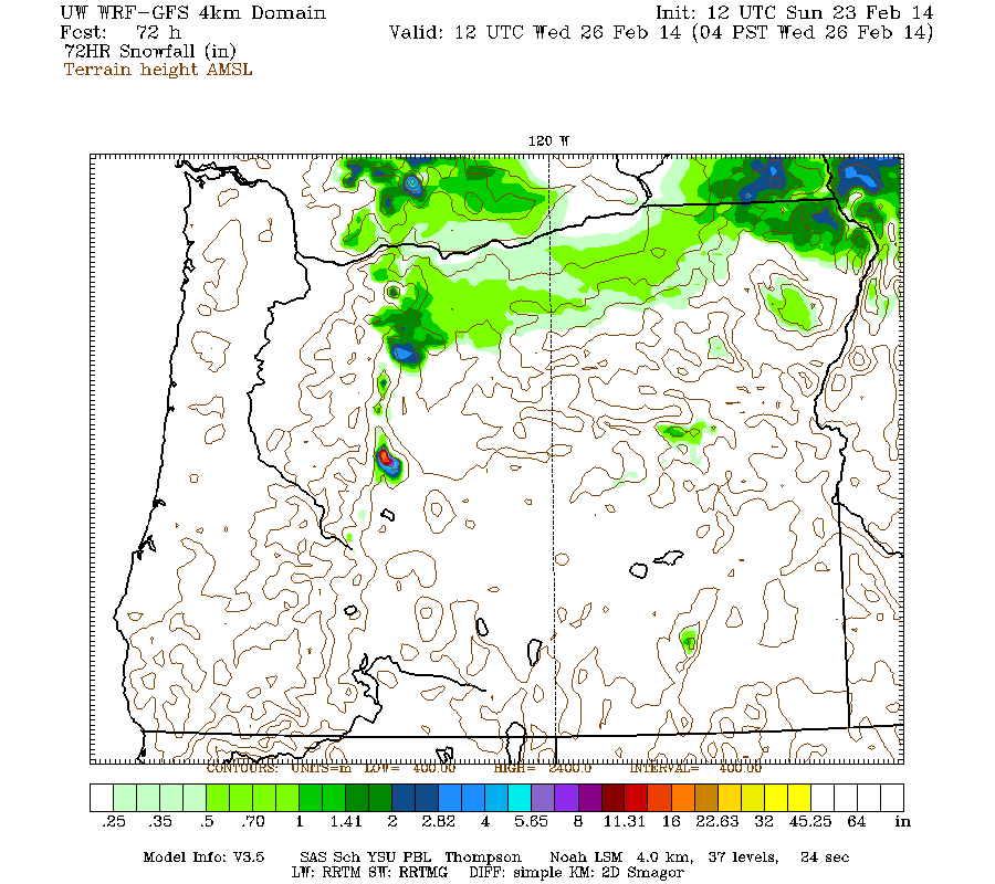
Higher resolution version of that, showing the Pacific Northwest and also zoomed in on Washington and Oregon:
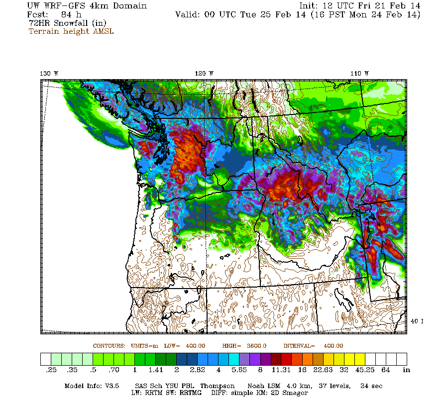
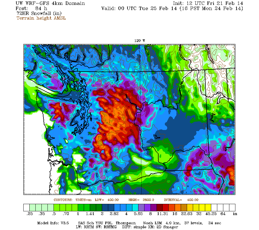
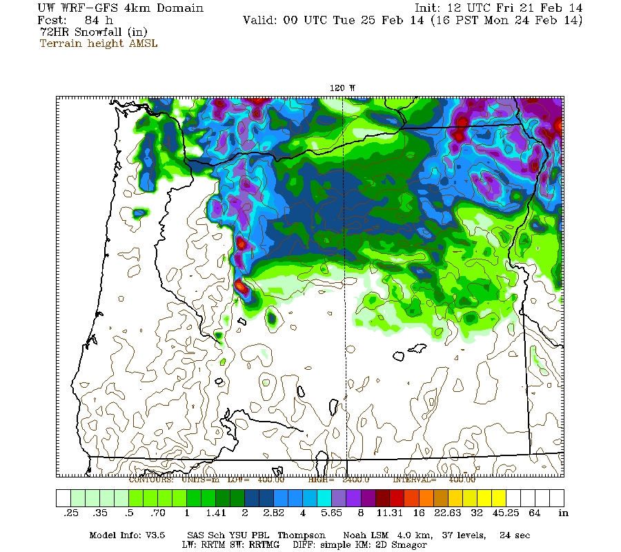
Maximum snowfall amounts of about 2-3 ft are shown on Mount Rainier, with large areas of 1-2 ft in the central WA Cascades and also high up on Mount Jefferson and the Three Sisters in Oregon.
The most unusual thing about the Washington image is the large area of lowland snowfall predicted over most of western Washington. This snowfall is expected in two shots, on Saturday from roughly Seattle northward throughout the northern Puget Sound, San Juan Islands, Bellingham area, Vancouver, and the Strait of Georgia, with amounts ranging up to several inches, and then a second shot farther south on Sunday night into Monday for the Seattle area and southwest Washington. It will be interesting to see if these predictions verify, since lowland snowfall is notoriously difficult to predict accurately in this region. Forecasts for lowland snow can go haywire at any time here.
This loop shows how the model predictions for snowfall during the 3-day period through 4pm Monday have evolved between 10 subsequent runs over the last 5 days, the D(model)/D(t). Unlike most of these loops shown previously in this thread (but similar to yesterday's), this one has varied wildly in its predictions, especially several days ago, but has become much more consistent in the most recent runs. That reflects the uncertainty over how this storm cycle would end, and the unexpected final systems now predicted over the weekend and into week:
www.atmos.washington.edu/~ovens/wxloop.c...2+v2014022500///+-st
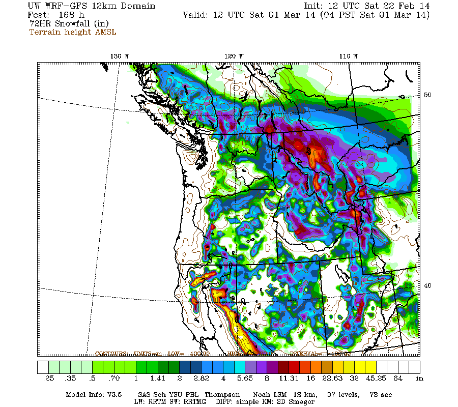
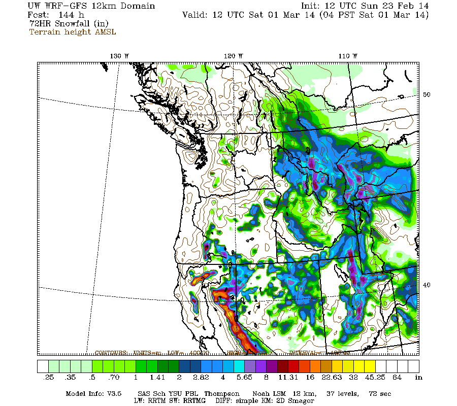
The next storm cycle is predicted to begin on Wednesday, with systems arriving from the southwest into northern California and southern Oregon over the rest of next week. It's another Pineapple Express type of atmospheric river event, although perhaps not as intense as the one which kicked off this storm cycle. Snowfall from that new storm cycle during the 3-day period ending 4pm next Friday is predicted to be up to 3-4 ft at higher elevations of the California Cascades, Trinity Alps, and Sierra Nevada, with lesser amounts in Oregon and very little extending north into Washington over that time period:
But that's a story for another storm cycle thread (maybe, maybe not -- I'm not sure if I'll actually bother writing about that one). And it's still 5-7 days out, near the limit of accurate numerical weather prediction, so that storm cycle is no sure thing quite yet.
with an additional 1-3 ft predicted through Tuesday including the possibility of lowland snowfall in western Washington!
The final stage of this lengthy storm cycle has arrived, following the most intense period of snowfall thus far in the 2013-14 season in the Pacific Northwest over the past 6 days, with several feet of new powder at lowering snow levels! The last systems of this storm cycle are expected to come over the weekend and into the start of next week, providing a final burst of snowfall for Washington and northern Oregon over the weekend into Tuesday.
Another day later, and 2 more subsequent runs of the UW WRF-GFS model at 12-hour intervals continue to predict a surprising conclusion to this storm cycle: TWO MORE shots of snow over the weekend into next week, including a significant chance of lowland snowfall in western Washington both times. The TV news has quickly latched onto this possibility, and panic may be about to set in once again in this region.
The jet stream (see Days 1-5 Jet Stream Analysis & Forecasts ) is still the key to what is likely to happen. By Saturday, the tail end of the strong jet stream which brought so much snowfall this week will have shifted eastward over the BC coast and be coming in from the north-northwest directly over Washington state, bringing the first shot of snow down from that direction (compare with the same image in Update #11 above, this image is almost identical to the prediction 3 days earlier):
By late Sunday and into Monday, the jet stream pattern will have evolved and shifted south and east over the central part of the continent, with only the entrance region of the jet over the Northwest, allowing another system to develop in that region and entrain some moisture from the southwest, providing a second shot at snow at that time:
By Wednesday, that jet has departed, this storm cycle is long over, and a new jet is about to land in California, where jets bearing large quantities of moisture are currently most welcome to land:
This large animated GIF image (47 frames like the image above, 2.6 MB) shows the entire evolution of the jet stream during this storm cycle at 12-hour intervals, from February 3 a few days before it started through today, plus predictions for the next 5 days through Wednesday, February 26. I think it's a fascinating way to watch how this entire complicated storm cycle originated and then played out:
www.skimountaineer.com/TR/Images2014/jetstream_pac-Feb2014.gif
The NWS's GFS model and their Quantitative Precipitation Forecasts are now showing up to 4-5" of precip in California from that new storm cycle next week, which is great news for that severely drought-stricken region. Here is total precipitation in inches predicted over the next 7 days through Friday afternoon, February 28, with almost all of that shown in the Pacific Northwest falling in the next 3+ days though Monday in Washington and early Tuesday in Oregon, and all of that in California during the 5-7 day period from Wednesday onward:
Snowfall during the next 3 days through 4pm Monday (which catches all but the tail end of the weekend systems) is predicted to be about 1 ft over most of the Washington Cascades and Olympics (more like 1-3 ft in the central Cascades and Mount Rainier), with several inches over southwestern BC and the northern Oregon Cascades:
Higher resolution version of that, showing the Pacific Northwest and also zoomed in on Washington and Oregon:
Maximum snowfall amounts of about 2-3 ft are shown on Mount Rainier, with large areas of 1-2 ft in the central WA Cascades and also high up on Mount Jefferson and the Three Sisters in Oregon.
The most unusual thing about the Washington image is the large area of lowland snowfall predicted over most of western Washington. This snowfall is expected in two shots, on Saturday from roughly Seattle northward throughout the northern Puget Sound, San Juan Islands, Bellingham area, Vancouver, and the Strait of Georgia, with amounts ranging up to several inches, and then a second shot farther south on Sunday night into Monday for the Seattle area and southwest Washington. It will be interesting to see if these predictions verify, since lowland snowfall is notoriously difficult to predict accurately in this region. Forecasts for lowland snow can go haywire at any time here.
This loop shows how the model predictions for snowfall during the 3-day period through 4pm Monday have evolved between 10 subsequent runs over the last 5 days, the D(model)/D(t). Unlike most of these loops shown previously in this thread (but similar to yesterday's), this one has varied wildly in its predictions, especially several days ago, but has become much more consistent in the most recent runs. That reflects the uncertainty over how this storm cycle would end, and the unexpected final systems now predicted over the weekend and into week:
www.atmos.washington.edu/~ovens/wxloop.c...2+v2014022500///+-st
The next storm cycle is predicted to begin on Wednesday, with systems arriving from the southwest into northern California and southern Oregon over the rest of next week. It's another Pineapple Express type of atmospheric river event, although perhaps not as intense as the one which kicked off this storm cycle. Snowfall from that new storm cycle during the 3-day period ending 4pm next Friday is predicted to be up to 3-4 ft at higher elevations of the California Cascades, Trinity Alps, and Sierra Nevada, with lesser amounts in Oregon and very little extending north into Washington over that time period:
But that's a story for another storm cycle thread (maybe, maybe not -- I'm not sure if I'll actually bother writing about that one). And it's still 5-7 days out, near the limit of accurate numerical weather prediction, so that storm cycle is no sure thing quite yet.
Please Log in or Create an account to join the conversation.
- Amar Andalkar
-
Topic Author
- User
-
Less
More
- Posts: 635
- Thank you received: 0
12 years 1 month ago - 12 years 1 month ago #220687
by Amar Andalkar
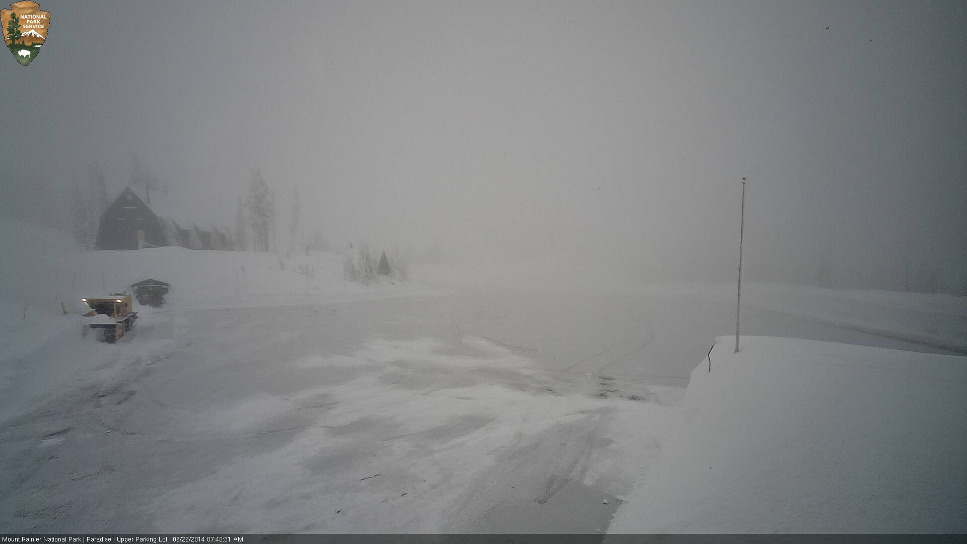
As expected, the road did open to the public on Saturday just after 10am . If the weather had been nicer, I probably would have gone up there for a look-see, but the thick clouds and whiteout nixed that idea.
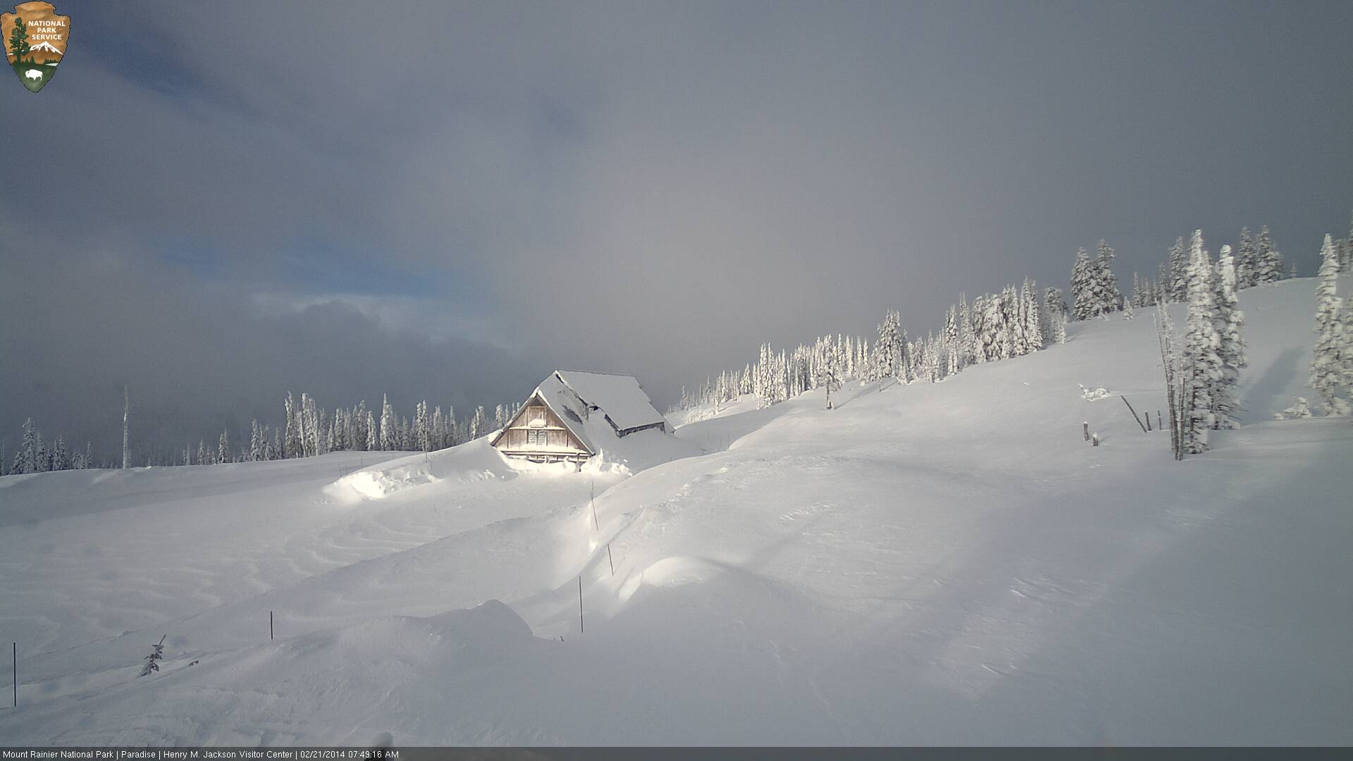
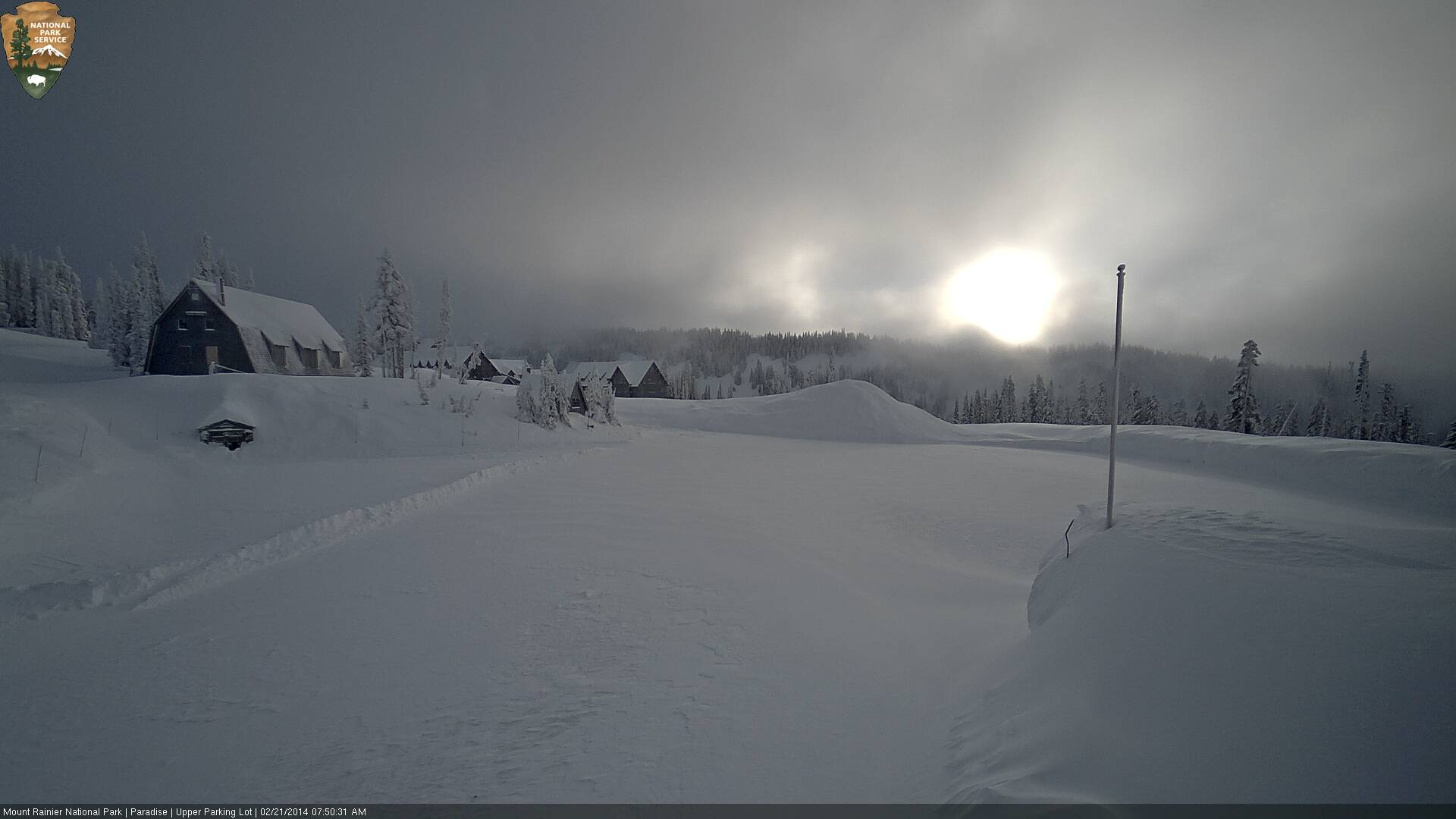
As of Friday morning, the Paradise parking lot had been partially plowed the day before, then refilled that evening and overnight due to additional snowfall and wind-drifitng:
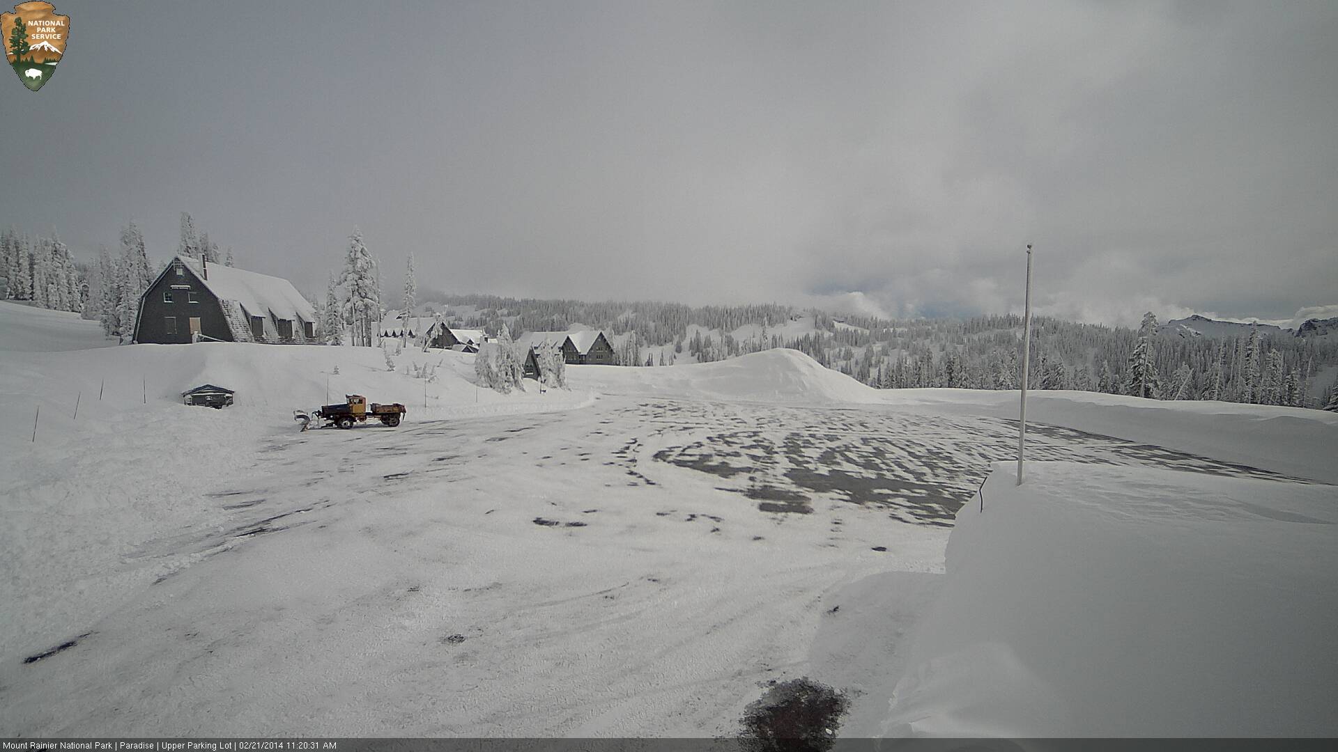
The lot was re-plowed almost completely before noon on Friday, but then plowing operations stopped as apparently it had been decided not to open the road that day. It certainly appears that the road could have opened Friday afternoon (not counting law enforcement staffing and other concerns):
The final bits were plowed out early Saturday, and the road opened a few hours later:
It's nice to have access once again to what is now by far the deepest road-accessible snowpack in North America, probably in the world, with 168" (14 ft) as of this morning following some settlement from the maximum value of 178" on February 20. Unless someplace in the snow belt on the west side of the Japanese Alps or Hokkaido currently has more. This table of Japanese ski resort snow depths shows several areas reporting over 430 cm / 169" today, but it's unclear if the depths listed in this table are at their bases or a higher station. A quick check of the Geto Kogen website reveals that the 540 cm / 213" depth is actually at their summit, with only 405 cm / 159" at the base, and similarly for Charmant Hiuchi . Here are the largest snowdepths as of February 22 at any Japanese ski resorts:
[tt]
Summit Summit Base Base
Elevation Snow Depth Elevation Snow Depth
Geto Kogen 3500 ft 540 cm / 213" 2100 ft 405 cm / 159"
Charmant Hiuchi 3300 ft 460 cm / 181" 1650 ft 363 cm / 143"
Kiroro Snow World 3850 ft 450 cm / 177" 1850 ft (only 1 depth listed)
Seki Onsen 3950 ft 450 cm / 177" 2950 ft (only 1 depth listed)
Sapporo Kokusai 3600 ft 430 cm / 169" 2050 ft (only 1 depth listed)
Tanigawadake 4900 ft 430 cm / 169" 2450 ft (only 1 depth listed)
[/tt]
I do not know if any Japanese national parks or highway passes currently have greater snow depths, this would be useful information to know where to find on the web.
[hr]Lots of lenticulars:
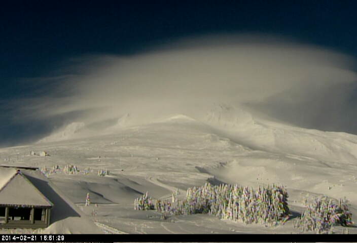
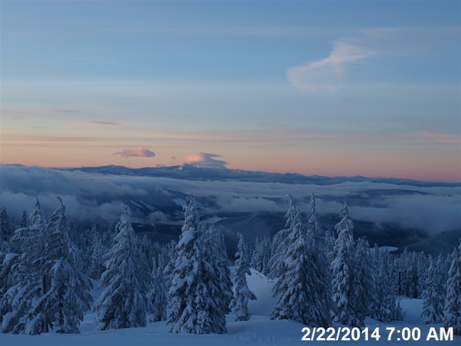
On another note, there were lots of interesting lenticular clouds out and visible during the lull between systems on Friday afternoon and Saturday morning, produced by the strong northwesterly winds aloft as the jet stream moved over the BC coast and aimed directly down into Washington and northern Oregon. February 21:
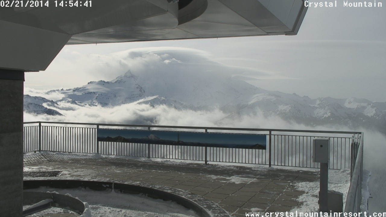
[size=small]Several complex lenticulars crown Mount Rainier on Friday afternoon, as seen from atop Crystal Mountain .[/size]
[size=small]Several complex lenticulars crown Mount Hood too on Friday afternoon, looking up from Timberline Lodge .[/size]
February 22:
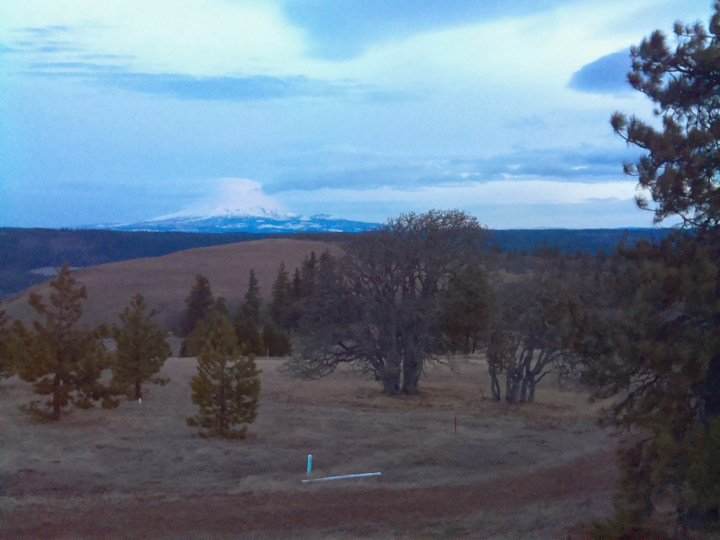
[size=small]Lenticulars at dawn on Mount Adams, looking NW from a high plateau above the Klickitat River canyon near Lyle (2014-02-22 6:48am).[/size]
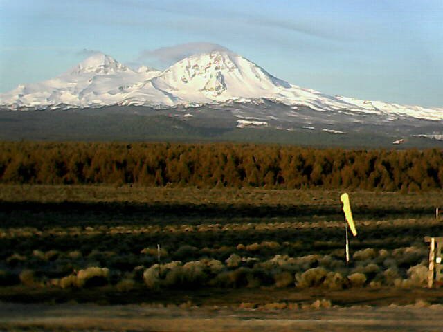
[size=small]Sunrise lenticulars on Mount Jefferson, looking south from Timberline Lodge on Mount Hood .[/size]
[size=small]Thin wispy lenticulars forming at sunrise on North Sister and Middle Sister, as seen on the Cascade Flyers webcam between Bend and Sisters (2014-02-22 7:09am).[/size]
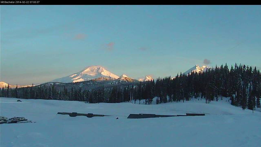
[size=small]Thin wispy lenticulars forming at sunrise on South Sister, Middle Sister, North Sister, and maybe even Broken Top (left to right) as seen from Mount Bachelor .
Same time as previous image, looking from the SE instead of the NE.[/size]
Replied by Amar Andalkar on topic Re: HUGE storm cycle brings 4-12 ft snow Feb6-21,2014!
As usual, a nice, detailed report, Amar. The big question is: Will Mt. Rainier open the road to Paradise this month?
I really shouldn't speculate about the road opening, that is not something that any computer model can yet forecast! But here goes:
This month: the road will open for certain again in February, barring some type of catastrophe.
This week: not likely on any weekday given 1-3 ft of new snow expected each day through Thursday.
But the storm cycle fades out around Friday, so a weekend opening seems reasonable (and Friday is perhaps possible).
As expected, the road did open to the public on Saturday just after 10am . If the weather had been nicer, I probably would have gone up there for a look-see, but the thick clouds and whiteout nixed that idea.
As of Friday morning, the Paradise parking lot had been partially plowed the day before, then refilled that evening and overnight due to additional snowfall and wind-drifitng:
The lot was re-plowed almost completely before noon on Friday, but then plowing operations stopped as apparently it had been decided not to open the road that day. It certainly appears that the road could have opened Friday afternoon (not counting law enforcement staffing and other concerns):
The final bits were plowed out early Saturday, and the road opened a few hours later:
It's nice to have access once again to what is now by far the deepest road-accessible snowpack in North America, probably in the world, with 168" (14 ft) as of this morning following some settlement from the maximum value of 178" on February 20. Unless someplace in the snow belt on the west side of the Japanese Alps or Hokkaido currently has more. This table of Japanese ski resort snow depths shows several areas reporting over 430 cm / 169" today, but it's unclear if the depths listed in this table are at their bases or a higher station. A quick check of the Geto Kogen website reveals that the 540 cm / 213" depth is actually at their summit, with only 405 cm / 159" at the base, and similarly for Charmant Hiuchi . Here are the largest snowdepths as of February 22 at any Japanese ski resorts:
[tt]
Summit Summit Base Base
Elevation Snow Depth Elevation Snow Depth
Geto Kogen 3500 ft 540 cm / 213" 2100 ft 405 cm / 159"
Charmant Hiuchi 3300 ft 460 cm / 181" 1650 ft 363 cm / 143"
Kiroro Snow World 3850 ft 450 cm / 177" 1850 ft (only 1 depth listed)
Seki Onsen 3950 ft 450 cm / 177" 2950 ft (only 1 depth listed)
Sapporo Kokusai 3600 ft 430 cm / 169" 2050 ft (only 1 depth listed)
Tanigawadake 4900 ft 430 cm / 169" 2450 ft (only 1 depth listed)
[/tt]
I do not know if any Japanese national parks or highway passes currently have greater snow depths, this would be useful information to know where to find on the web.
[hr]Lots of lenticulars:
On another note, there were lots of interesting lenticular clouds out and visible during the lull between systems on Friday afternoon and Saturday morning, produced by the strong northwesterly winds aloft as the jet stream moved over the BC coast and aimed directly down into Washington and northern Oregon. February 21:
[size=small]Several complex lenticulars crown Mount Rainier on Friday afternoon, as seen from atop Crystal Mountain .[/size]
[size=small]Several complex lenticulars crown Mount Hood too on Friday afternoon, looking up from Timberline Lodge .[/size]
February 22:
[size=small]Lenticulars at dawn on Mount Adams, looking NW from a high plateau above the Klickitat River canyon near Lyle (2014-02-22 6:48am).[/size]
[size=small]Sunrise lenticulars on Mount Jefferson, looking south from Timberline Lodge on Mount Hood .[/size]
[size=small]Thin wispy lenticulars forming at sunrise on North Sister and Middle Sister, as seen on the Cascade Flyers webcam between Bend and Sisters (2014-02-22 7:09am).[/size]
[size=small]Thin wispy lenticulars forming at sunrise on South Sister, Middle Sister, North Sister, and maybe even Broken Top (left to right) as seen from Mount Bachelor .
Same time as previous image, looking from the SE instead of the NE.[/size]
Please Log in or Create an account to join the conversation.
- Amar Andalkar
-
Topic Author
- User
-
Less
More
- Posts: 635
- Thank you received: 0
12 years 1 month ago - 12 years 1 month ago #220690
by Amar Andalkar
Replied by Amar Andalkar on topic Re: HUGE storm cycle brings 4-14 ft snow Feb6-25,2014!
Update #14: 384 hours (16 days) after initial post, 2-12 ft of snow has already fallen along the coast from Alaska to California,
with an additional 1-3 ft predicted through Tuesday including the (diminishing) possibility of lowland snowfall in western Washington!
Just a brief update this time. Another day later, and 2 more subsequent runs of the UW WRF-GFS model at 12-hour intervals still continue to predict an additional 1-3 ft of snowfall over the Washington Cascades through Tuesday morning. However, the chance of any more lowland snow in western Washington either today or Monday has diminished to nearly zero in the recent runs, so a general panic may no longer be necessary in this region.
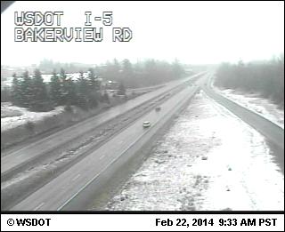
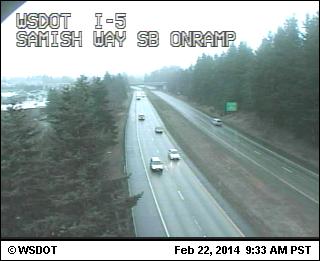
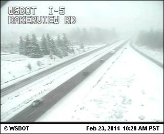
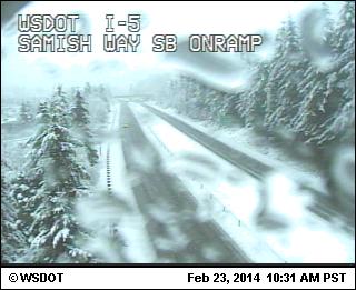
As predicted, following Friday's lull a system did arrive in northwesterly flow on Saturday morning, including a bit of lowland of snow in northwestern Washington. Amounts were minimal at generally less than 1", the areas that got snow were discontinuous, and scenes like this were typical, with snowy and bare areas interspersed over just a few miles of I-5 from MP 258 to 246 near Bellingham (elevations of these webcams are about 200 ft, 200 ft, and 560 ft at I-5 at Lake Samish Park and Ride in the last image):
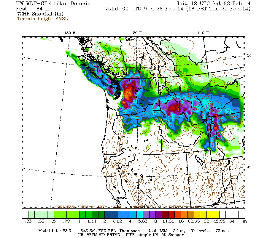
Snowfall in the Washington Cascades is expected to intensify later today and into Sunday morning, with the next system arriving almost immediately afterward on Sunday afternoon and continuing into Monday, while moving southward into northern Oregon. Snowfall during the next 3 days through 4pm Tuesday (which catches all the remaining parts of the weekend systems) is predicted to be about 1 ft over most of the Washington Cascades and Olympics (more like 1-3 ft in the central Cascades and Mount Rainier), with several inches over Vancouver Island and the northern Oregon Cascades, and very little over the mainland of southwestern BC:
Higher resolution version of that, showing the Pacific Northwest and also zoomed in on Washington and Oregon:
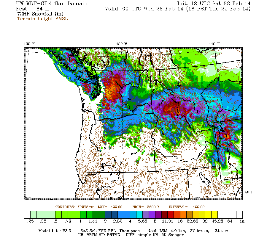
Maximum snowfall amounts of about 2-3 ft are shown on Mount Rainier, with large areas of 1-2 ft in the central WA Cascades and also high up in the Three Sisters in Oregon. The lowland snowfall has almost completely vanished from the Washington image compared to 24 hours earlier (see Update #13 above), not unexpectedly at all. The remaining areas of lowland snow are mainly limited to the San Juan Islands and along the Strait of Juan de Fuca. There's still a chance that later model runs might once again predict more widespread lowland snow for Sunday-Monday, or that it might snow anyway in other areas despite model predictions stating that it won't.
This loop shows how the model predictions for snowfall during the 3-day period through 4pm Tuesday have evolved between 10 subsequent runs over the last 5 days, the D(model)/D(t). Very consistent in the overall picture throughout although with minor variations, which shows that the model had locked on to the solution predicting additional storms this weekend by about 4-5 days ago:
www.atmos.washington.edu/~ovens/wxloop.c...2+v2014022600///+-st
The next storm cycle is still predicted to begin on Wednesday, with the first system arriving from the southwest into northern California and southern Oregon that morning and then a stronger system on Friday into Saturday. Snowfall from that new storm cycle during the 3-day period ending 4am next Saturday is still predicted to be up to 3-4 ft at higher elevations of the California Cascades and Trinity Alps and 3-5 ft in the Sierra Nevada, with lesser amounts in Oregon and Washington:
Although that's still 4-7 days out and near the limit of accurate numerical weather prediction, the consistency between subsequent model runs indicates that this critically-needed major storm cycle for California is increasingly likely to actually occur.
with an additional 1-3 ft predicted through Tuesday including the (diminishing) possibility of lowland snowfall in western Washington!
Just a brief update this time. Another day later, and 2 more subsequent runs of the UW WRF-GFS model at 12-hour intervals still continue to predict an additional 1-3 ft of snowfall over the Washington Cascades through Tuesday morning. However, the chance of any more lowland snow in western Washington either today or Monday has diminished to nearly zero in the recent runs, so a general panic may no longer be necessary in this region.
As predicted, following Friday's lull a system did arrive in northwesterly flow on Saturday morning, including a bit of lowland of snow in northwestern Washington. Amounts were minimal at generally less than 1", the areas that got snow were discontinuous, and scenes like this were typical, with snowy and bare areas interspersed over just a few miles of I-5 from MP 258 to 246 near Bellingham (elevations of these webcams are about 200 ft, 200 ft, and 560 ft at I-5 at Lake Samish Park and Ride in the last image):
Snowfall in the Washington Cascades is expected to intensify later today and into Sunday morning, with the next system arriving almost immediately afterward on Sunday afternoon and continuing into Monday, while moving southward into northern Oregon. Snowfall during the next 3 days through 4pm Tuesday (which catches all the remaining parts of the weekend systems) is predicted to be about 1 ft over most of the Washington Cascades and Olympics (more like 1-3 ft in the central Cascades and Mount Rainier), with several inches over Vancouver Island and the northern Oregon Cascades, and very little over the mainland of southwestern BC:
Higher resolution version of that, showing the Pacific Northwest and also zoomed in on Washington and Oregon:
Maximum snowfall amounts of about 2-3 ft are shown on Mount Rainier, with large areas of 1-2 ft in the central WA Cascades and also high up in the Three Sisters in Oregon. The lowland snowfall has almost completely vanished from the Washington image compared to 24 hours earlier (see Update #13 above), not unexpectedly at all. The remaining areas of lowland snow are mainly limited to the San Juan Islands and along the Strait of Juan de Fuca. There's still a chance that later model runs might once again predict more widespread lowland snow for Sunday-Monday, or that it might snow anyway in other areas despite model predictions stating that it won't.
This loop shows how the model predictions for snowfall during the 3-day period through 4pm Tuesday have evolved between 10 subsequent runs over the last 5 days, the D(model)/D(t). Very consistent in the overall picture throughout although with minor variations, which shows that the model had locked on to the solution predicting additional storms this weekend by about 4-5 days ago:
www.atmos.washington.edu/~ovens/wxloop.c...2+v2014022600///+-st
The next storm cycle is still predicted to begin on Wednesday, with the first system arriving from the southwest into northern California and southern Oregon that morning and then a stronger system on Friday into Saturday. Snowfall from that new storm cycle during the 3-day period ending 4am next Saturday is still predicted to be up to 3-4 ft at higher elevations of the California Cascades and Trinity Alps and 3-5 ft in the Sierra Nevada, with lesser amounts in Oregon and Washington:
Although that's still 4-7 days out and near the limit of accurate numerical weather prediction, the consistency between subsequent model runs indicates that this critically-needed major storm cycle for California is increasingly likely to actually occur.
Please Log in or Create an account to join the conversation.
- Amar Andalkar
-
Topic Author
- User
-
Less
More
- Posts: 635
- Thank you received: 0
12 years 1 month ago - 12 years 1 month ago #220713
by Amar Andalkar
Replied by Amar Andalkar on topic Re: HUGE storm cycle brings 4-14 ft snow Feb6-25,2014!
[size=small]Wasn't planning to write an update today as I was intending to ski. But feeling a bit sick for the last couple of days, with a sore throat and now a cough, the first time I've had a cold in a very long time. So unfortunately I'm choosing to miss out on the fine ski conditions. At least I can sit here and watch the snow continue to pile up, deeper and deeper, and keep writing about it too:[/size]
Update #15: 408 hours (17 days) after initial post, 2-12 ft of snow has already fallen along the coast from Alaska to California,
with an additional 1-1.5 ft predicted through Tuesday including the (diminishing) possibility of lowland snowfall in western Washington!
Another brief update in the waning days of this storm cycle. Another day later, and 2 more subsequent runs of the UW WRF-GFS model at 12-hour intervals still continue to predict up to an additional 1-1.5 ft of snowfall over the Washington Cascades through Tuesday morning. However, the chance of any lowland snow in western Washington south of Bellingham on Sunday night into Monday has diminished to nearly zero over the last 2 days of model runs.
As of Sunday morning, about 3-15" of new snow has been received over the past 24 hours from about Whistler south to Mount Rainier, with only an inch or two farther south to Mount Hood, and clear skies beyond that on Mount Bachelor and into California. The largest new snowfalls were on the North Shore of Vancouver and in parts of the North Cascades with over 1 ft, topped by 15" at Mount Seymour, 13" at Cypress Mountain, 12" at Grouse Mountain, over 15" at the Chilliwack River BCRFC site (5300 ft in the BC Cascades just north of the US border near Mount Baker), 12" at Mount Baker Ski Area, and 14" at Holden Village. This area of maximum snowfall was definitely farther north than the model had predicted, as it had shown 1 ft amounts in the Central Cascades with only a few inches on Mount Baker or the North Shore of Vancouver.
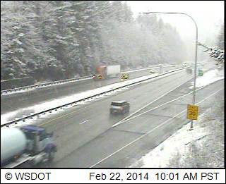
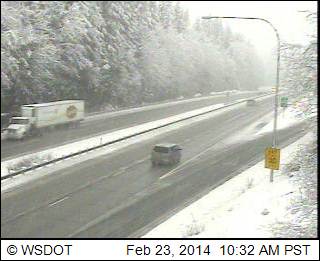
There was a bigger dose of lowland of snow in northwestern Washington overnight and this morning than on Saturday morning, with amounts up to a few inches this time. Definitely more snow and much more continuous snow on these same 3 webcams than yesterday, along I-5 from MP 258 to 246 near Bellingham (elevations of these webcams are about 200 ft, 200 ft, and 560 ft at I-5 at Lake Samish Park and Ride in the last image):
Snowfall in the Washington Cascades is again expected to intensify later Sunday afternoon and continue through Monday, while moving southward into northern Oregon. Snowfall during the next 3 days through 4am Wednesday (which catches all the remaining parts of the weekend systems) is predicted to be up to 1-1.5 ft over most of the Washington Cascades north of Mount Rainier, with several inches over Vancouver Island, parts of the mainland of southwestern BC, the Olympics, the southern Washington Cascades, and the parts of the northern Oregon Cascades:
Higher resolution version of that, showing the Pacific Northwest and also zoomed in on Washington and Oregon:
Maximum snowfall amounts of about 1-1.5 ft are shown on Mount Rainier and large areas of the central WA Cascades and also high up in the Three Sisters in Oregon. The lowland snowfall is still almost completely absent from the Washington image similar to 24 hours earlier (see Update #14 above), with the remaining areas of lowland snow still limited to northwest Washington, the San Juan Islands, and along the Strait of Juan de Fuca. There's still a small chance that it might snow anyway in other areas despite model predictions stating that it won't, but temperatures are likely to remain just too warm farther south than that area.
This loop shows how the model predictions for snowfall during the 3-day period through 4am Wednesday have evolved between 10 subsequent runs over the last 5 days, the D(model)/D(t). Very consistent in the overall picture throughout although with minor variations, which shows that the model had locked on to the solution predicting additional storms this weekend by about 5 days ago. The biggest change has been a sharp reduction in snowfall amounts for northern Oregon over the most recent runs, which is primarily due to greater warming down there rather than a large reduction in predicted precip amounts:
www.atmos.washington.edu/~ovens/wxloop.c...2+v2014022612///+-st
The next storm cycle is still predicted to begin on Wednesday, with the first system arriving from the southwest into northern California and southern Oregon that morning and then another system on Friday into Saturday and Sunday. Snowfall from that new storm cycle during the 3-day period ending 4am next Saturday is now predicted to be up to 2-3 ft at higher elevations of the California Cascades, Trinity Alps, and Sierra Nevada, a fairly significant reduction from 24 hours ago:
It still appears likely that this critically-needed major storm cycle for California will actually occur, but details and timing continue to change substantially on subsequent model runs, as do the total snowfall amounts as seen in the D(model)/D(t) for this period, including 4 runs over the last 2 days:
www.atmos.washington.edu/~ovens/wxloop.c...2+v2014030112///+-st
Update #15: 408 hours (17 days) after initial post, 2-12 ft of snow has already fallen along the coast from Alaska to California,
with an additional 1-1.5 ft predicted through Tuesday including the (diminishing) possibility of lowland snowfall in western Washington!
Another brief update in the waning days of this storm cycle. Another day later, and 2 more subsequent runs of the UW WRF-GFS model at 12-hour intervals still continue to predict up to an additional 1-1.5 ft of snowfall over the Washington Cascades through Tuesday morning. However, the chance of any lowland snow in western Washington south of Bellingham on Sunday night into Monday has diminished to nearly zero over the last 2 days of model runs.
As of Sunday morning, about 3-15" of new snow has been received over the past 24 hours from about Whistler south to Mount Rainier, with only an inch or two farther south to Mount Hood, and clear skies beyond that on Mount Bachelor and into California. The largest new snowfalls were on the North Shore of Vancouver and in parts of the North Cascades with over 1 ft, topped by 15" at Mount Seymour, 13" at Cypress Mountain, 12" at Grouse Mountain, over 15" at the Chilliwack River BCRFC site (5300 ft in the BC Cascades just north of the US border near Mount Baker), 12" at Mount Baker Ski Area, and 14" at Holden Village. This area of maximum snowfall was definitely farther north than the model had predicted, as it had shown 1 ft amounts in the Central Cascades with only a few inches on Mount Baker or the North Shore of Vancouver.
There was a bigger dose of lowland of snow in northwestern Washington overnight and this morning than on Saturday morning, with amounts up to a few inches this time. Definitely more snow and much more continuous snow on these same 3 webcams than yesterday, along I-5 from MP 258 to 246 near Bellingham (elevations of these webcams are about 200 ft, 200 ft, and 560 ft at I-5 at Lake Samish Park and Ride in the last image):
Snowfall in the Washington Cascades is again expected to intensify later Sunday afternoon and continue through Monday, while moving southward into northern Oregon. Snowfall during the next 3 days through 4am Wednesday (which catches all the remaining parts of the weekend systems) is predicted to be up to 1-1.5 ft over most of the Washington Cascades north of Mount Rainier, with several inches over Vancouver Island, parts of the mainland of southwestern BC, the Olympics, the southern Washington Cascades, and the parts of the northern Oregon Cascades:
Higher resolution version of that, showing the Pacific Northwest and also zoomed in on Washington and Oregon:
Maximum snowfall amounts of about 1-1.5 ft are shown on Mount Rainier and large areas of the central WA Cascades and also high up in the Three Sisters in Oregon. The lowland snowfall is still almost completely absent from the Washington image similar to 24 hours earlier (see Update #14 above), with the remaining areas of lowland snow still limited to northwest Washington, the San Juan Islands, and along the Strait of Juan de Fuca. There's still a small chance that it might snow anyway in other areas despite model predictions stating that it won't, but temperatures are likely to remain just too warm farther south than that area.
This loop shows how the model predictions for snowfall during the 3-day period through 4am Wednesday have evolved between 10 subsequent runs over the last 5 days, the D(model)/D(t). Very consistent in the overall picture throughout although with minor variations, which shows that the model had locked on to the solution predicting additional storms this weekend by about 5 days ago. The biggest change has been a sharp reduction in snowfall amounts for northern Oregon over the most recent runs, which is primarily due to greater warming down there rather than a large reduction in predicted precip amounts:
www.atmos.washington.edu/~ovens/wxloop.c...2+v2014022612///+-st
The next storm cycle is still predicted to begin on Wednesday, with the first system arriving from the southwest into northern California and southern Oregon that morning and then another system on Friday into Saturday and Sunday. Snowfall from that new storm cycle during the 3-day period ending 4am next Saturday is now predicted to be up to 2-3 ft at higher elevations of the California Cascades, Trinity Alps, and Sierra Nevada, a fairly significant reduction from 24 hours ago:
It still appears likely that this critically-needed major storm cycle for California will actually occur, but details and timing continue to change substantially on subsequent model runs, as do the total snowfall amounts as seen in the D(model)/D(t) for this period, including 4 runs over the last 2 days:
www.atmos.washington.edu/~ovens/wxloop.c...2+v2014030112///+-st
Please Log in or Create an account to join the conversation.