- Posts: 25
- Thank you received: 0
HUGE storm cycle brings 4-14 ft snow Feb6-25,2014!
- andybrnr
-

- User
-

Less
More
12 years 2 months ago #220349
by andybrnr
Replied by andybrnr on topic Re: Next major storm brings 4-6 ft snow Feb 6-14,2014!
Just chatted with David, the snow products will now only be offline between June 30th and September 1st. The 700mb temps/winds/heights should be plotted out to 180 hours for the extended forecasts starting with the next run.
Please Log in or Create an account to join the conversation.
- Amar Andalkar
-
Topic Author
- User
-
Less
More
- Posts: 635
- Thank you received: 0
12 years 2 months ago #220350
by Amar Andalkar
Replied by Amar Andalkar on topic Re: Next major storm brings 4-6 ft snow Feb 6-14,2014!
Excellent! Thanks.
Please Log in or Create an account to join the conversation.
- Amar Andalkar
-
Topic Author
- User
-
Less
More
- Posts: 635
- Thank you received: 0
12 years 2 months ago - 12 years 2 months ago #219924
by Amar Andalkar
Replied by Amar Andalkar on topic Re: Next major storm brings 4-6 ft snow Feb 6-14,2014!
Update #7: 168 hours after initial post, 2-6 ft has already fallen in southwest BC, Washington, Oregon, and California,
with an additional 4-8 ft of snow (or more) predicted over the next week for WA, OR, and southwest BC!
Another day later, and 2 more subsequent runs of the UW WRF-GFS model at 12-hour intervals continue to predict large snowfall amounts of 4-8 ft (and perhaps much more) over the next week for Washington, Oregon, and southwest BC, along with about 3-5 ft in northern California. This is in addition to 2-6 ft of snow which has already fallen over the past 7 days at most mountain sites from Bella Coola, BC, all the way south to Mammoth Mountain, a span of about 1100 miles as the crow flies (and well over 1500 miles by car). The predicted amounts for both precip and snowfall over the next week remain similar to those predicted during the last 3-5 days, a good sign of stability in the model's predictions, with a continuing increase in overall totals as further storm systems come into view this weekend and into next week. If these predictions verify and the storm cycle continues as expected for another week, this will end up solidly in the HUGE storm cycle category with 10-day snowfall totals exceeding 10 ft at many sites especially above 4000-5000 ft in the Washington and northern Oregon Cascades plus southwestern BC.
The first stage of this storm cycle, aimed primarily at the Sierra Nevada (an atmospheric river) and also at Oregon and southern Washington (frontal snowfall along the boundary between a modified Arctic air mass and warmer air to the south), began early on Thursday, February 6, and ended during the day Monday, February 10. The second stage of this storm cycle started early Monday morning and will extend throughout this weekend into next week, featuring a series of fronts and systems every 1-2 days in strong westerly and southwesterly flow over the north Pacific, aimed primarily at Oregon, Washington, and southwestern British Columbia. The first system of the second stage came ashore Monday morning, and the next much stronger system arrived in the same region on Tuesday afternoon, including another atmospheric river event aimed at Oregon, a few hundred miles farther north than the first atmospheric river aimed at the central Sierra Nevada. This atmospheric river is expected to stay in place for another 2-3 days while slowly shifting southward, weakening slightly today and more significantly by Saturday afternoon as it eventually shifts a couple hundred miles farther south into northern California, which will bring some more precipitation to that area over the weekend, before it finally fades away on Sunday.
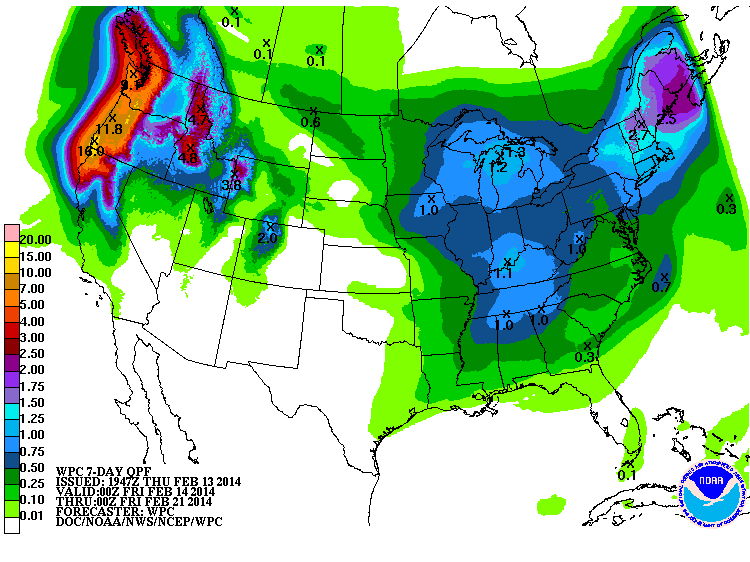
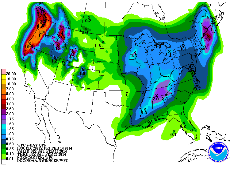
The NWS's GFS model and their Quantitative Precipitation Forecasts continue to show up to 8-16" of precip over the next week for the mountains of southwestern BC, Washington, Oregon, and northwestern California, with much smaller amounts of only 1-3" extending farther south into the northern Sierra. Here is total precipitation in inches predicted over the next 7 days through the afternoon of Thursday, February 20:
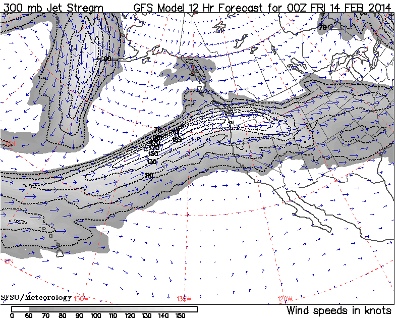
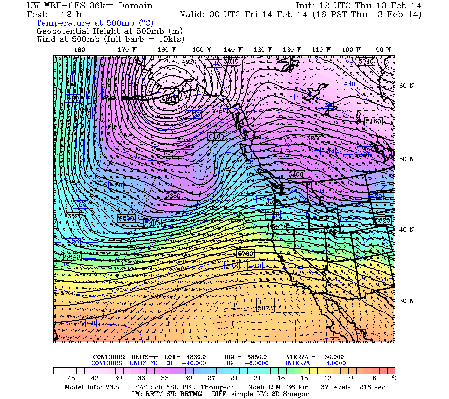
The fire hose of the jet stream (see Days 1-5 Jet Stream Analysis & Forecasts ) will be aimed directly into the Pacific Northwest the rest of this week and into the middle of next week, still peaking in intensity at almost 190 knots (about 220 mph) today. Here is the jet stream for 4pm Thursday afternoon:
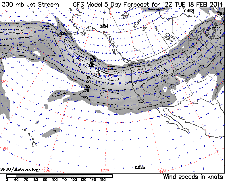
By Sunday the jet stream pattern is expected to have evolved and shifted, now approaching directly from the west, and remain that way through Tuesday, February 18 -- a much better direction for large snowfall totals at much lower snow levels:

Following a minor lull between systems during the day Wednesday in Washington (not much of a lull in Oregon), the next slightly cooler system arrived later Wednesday evening and overnight through Thursday. The system Wednesday night again featured very high winds, with maximum gusts of over 100 mph at Mission Ridge, White Pass, and Mt Hood Meadows (Top of Cascade Express), and over 90 mph atop Alpental.
As of Thursday morning, February 13, another 3-12" of new snow has fallen over the previous 24 hours at higher elevations throughout the Washington and northern Oregon Cascades, Olympics, and southwestern BC extending north past Whistler. Snow levels overnight into early Thursday were about 3000 ft near Whistler, 4000 ft in the North Cascades, 4500 ft near Stevens and Snoqualmie Passes, 5000 ft from Crystal and Mount Rainier south to White Pass, 6000 ft in the northern Oregon Cascades, and 7000 ft in the southern Oregon Cascades, but were already beginning to drop quickly by Thursday morning. This time the largest snowfall amounts were about 12" new at Brown Top SNOTEL (North Cascades) and Washington Pass, 10" in Mazama, about 9-12" at the Squamish River (4550 ft, west of Whistler), Spuzzum Creek (3950 ft, east of Harrison Lake), and Chilliwack River (5300 ft in the BC Cascades just north of the US border) BCRFC sites, 9" at Mount Washington (4500 ft) on Vancouver Island (which reopens today after being closed for the past 2 weeks due to insufficient snowpack), over 10" atop Alpental, and 9-11" at Mount Bachelor (6300 and 7300 ft). Mount Hood received over 2" of precipitation with about 3" new snow at Timberline at 5900 ft, but snowfall amounts of 1-1.5 ft were likely above 6500 ft.
Throughout the Cascade Range, Olympics, and southwestern BC, snow totals thus far since the storm cycle began early on February 6 range from 2 ft at the Burnt Bridge Creek BCRFC site (4400 ft, east of Bella Coola), 3 ft at Squamish River , 2 ft at Whistler, 3.5 ft at Spuzzum Creek , 3 ft at Mount Washington on Vancouver Island, 1.5 ft at Hurricane Ridge and 2.5 ft at Buckinghorse SNOTEL in the Olympics, 3 ft at Mount Baker, 3.5 ft at Brown Top SNOTEL and Washington Pass, 2-3 ft in much of the North Cascades, 3 ft at Stevens Pass, 2 ft at Snoqualmie Pass (with 4 ft atop Alpental), 1.5 ft at Mission Ridge, 2-2.5 ft at Crystal, 3 ft at Mount Rainier Paradise, 3.5 ft at White Pass, 4 ft at Mount Hood (with perhaps 6 ft above 7000 ft), 2.5 ft at Santiam Pass, 5-5.5 ft on Mount Bachelor, 3 ft at Willamette Pass, 2.5-3 ft at Crater Lake, 1.5-2.5 ft on Mount Shasta, and roughly 2-4 ft on Lassen Peak (actual totals there are unknown due to a long-term outage at the 8250 ft Lake Helen telemetry site, plus the complete wintertime closure of the visitor center at the park's 6700 ft southwest entrance due to budget concerns, where daily snowfall measurements are normally taken). In the Sierra Nevada, snowfall totals as of the end of the first stage of this storm cycle on February 10 were about 5-7 ft at many ski area upper stations near Lake Tahoe above 8000 ft, with more like 1-2 ft total at the 6000 ft level. Areas farther south such as Yosemite and Mammoth received much less snowfall, only about 2-3 ft even at 9000 ft, and only 2" total at 9000 ft on June Mountain located just north of Mammoth in the rain shadow of the Sierra Crest. See the table in the next post below for more complete snow and precip totals at over 180 measurement sites.
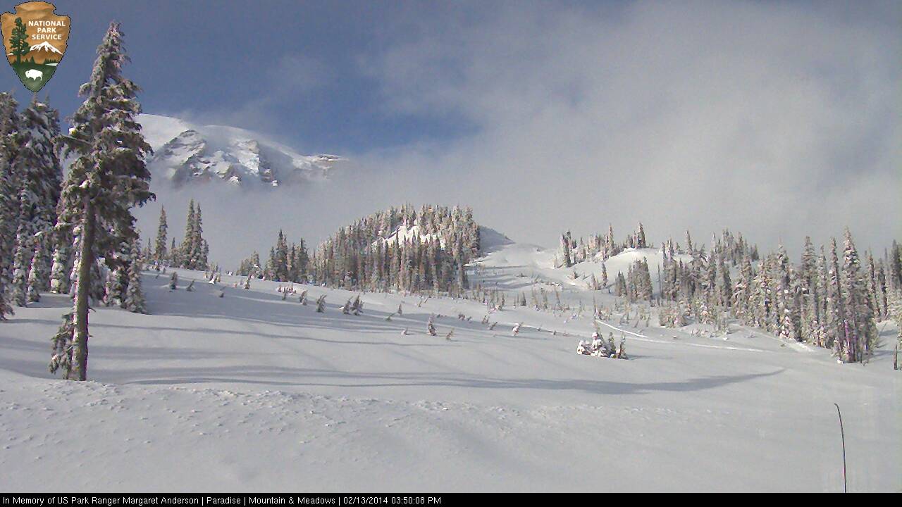
[size=small]The Mountain comes out AGAIN on Thursday afternoon during a lull between systems, but no lenticular this time unlike yesterday.[/size]
There is another minor lull between systems on Thursday afternoon and evening, then the next stronger system arrives by midnight and continues through Friday. Yet more systems are in the pipeline for Saturday afternoon and Sunday afternoon. The current stage of this storm cycle is also producing heavy snowfall in southeast Alaska, today and again over the weekend, all due to various low-pressure systems spawned from the same parent low in the Gulf of Alaska which has been associated with this entire storm cycle. Here is a wider view from the 36km resolution, showing several feet of snowfall in southeast Alaska through Sunday:
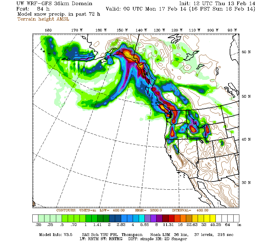
[size=small](This is actually model snow precip and not snowfall, but that distinction is unimportant for this image.)[/size]
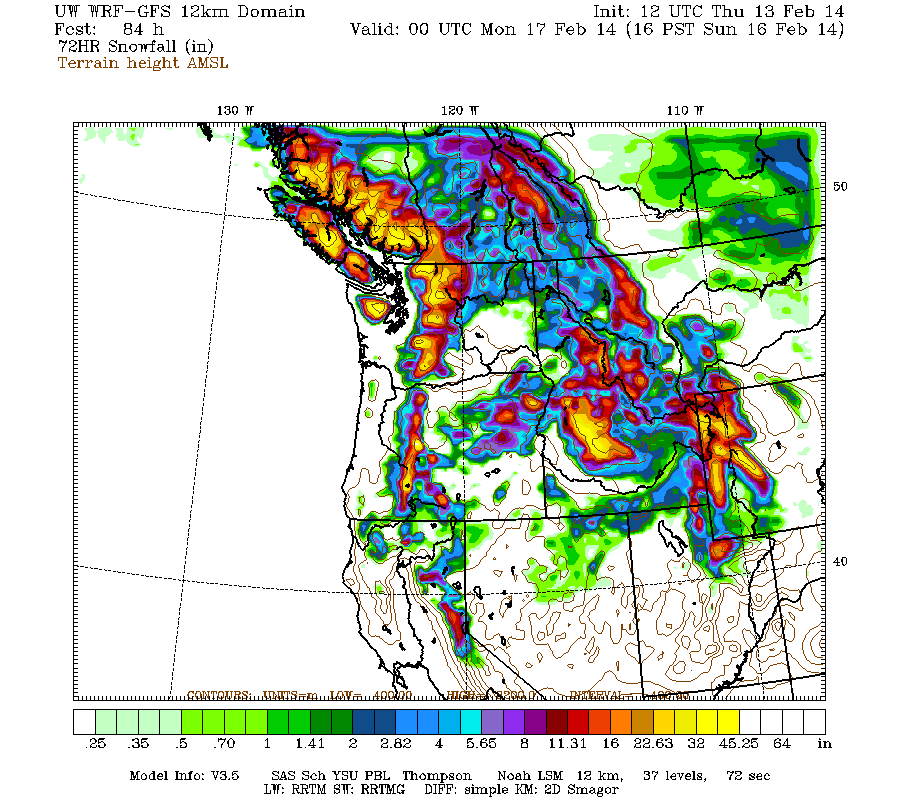
Snowfall during the next 3 days through 4pm Sunday is predicted to be 3-5 ft over the west slopes and volcanic peaks of the Washington and northern Oregon Cascades, the Olympics, and southwestern BC, with perhaps up to 1 ft extending into the California Cascades and northern Sierra Nevada on Saturday and Sunday:
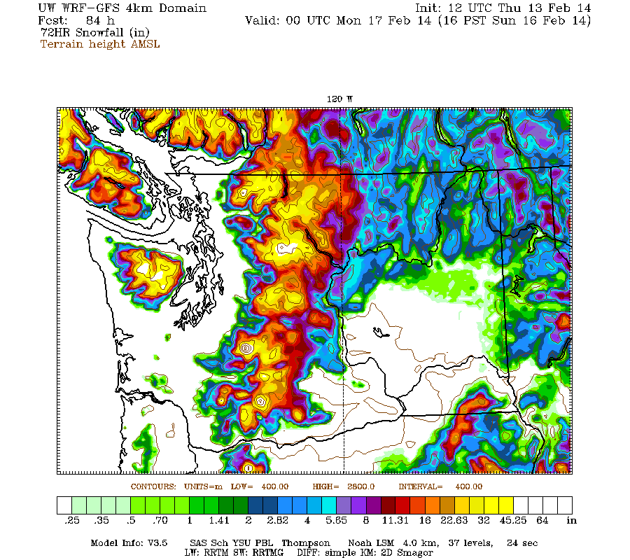
Higher resolution version of that, showing the Pacific Northwest and also zoomed in on Washington and Oregon:
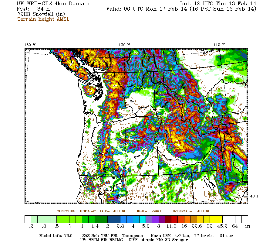
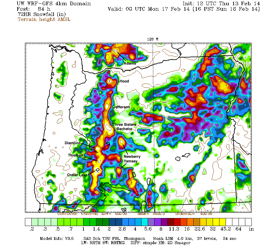
Maximum snowfall amounts of 4-5 ft (marked by white inside yellow) are shown along the west slopes of the Olympics and the volcanic peaks of the Washington and Oregon Cascades. In Oregon, even Newberry Volcano and Yamsay Mountain (another large shield volcano east of Crater Lake, the highest volcano in the eastern Cascade chain at 8196 ft) are shown with 3-4 ft expected, shocking given that both are 30 miles east of the Cascade Crest and normally quite rain-shadowed! Some major volcanoes have been labeled on the last graphic for clarity.
This loop shows how the model predictions for snowfall during the 3-day period through 4pm Sunday have evolved between 8 subsequent runs over the last 4 days, the D(model)/D(t). Very consistent in the overall picture throughout, with snowfall amounts increasing and decreasing a bit, but no major changes except for a trend towards more snowfall in the California Cascades on the latest runs:
www.atmos.washington.edu/~ovens/wxloop.c...2+v2014021700///+-st
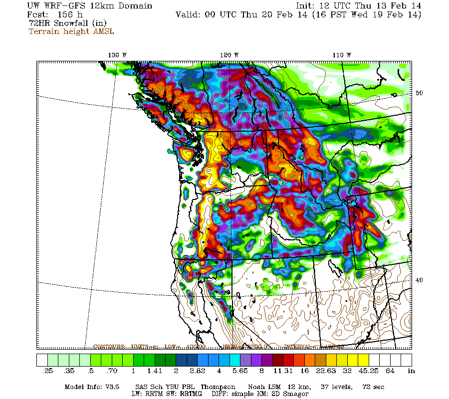
Additional snowfall during the subsequent 3 days ending 4pm next Wednesday is predicted to be another 3-6 ft over the west slopes and volcanic peaks of the Washington and Oregon Cascades plus the Olympics, with 2-3 ft extending north into southwestern BC and south into the California Cascades and Trinity Alps. These systems from Sunday through early next week are also likely to feature somewhat lower snow levels than the systems thus far this week.
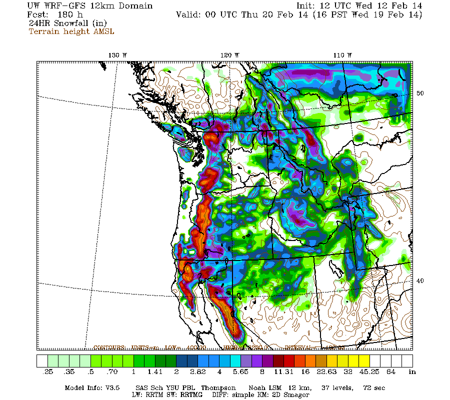
Beyond that point, it appears that this storm cycle is likely to continue to bring additional systems ashore every 1-2 days through next Thursday or Friday. Additional snowfall during the 1 day period ending 4pm next Thursday is predicted to be 1-2 ft over the Washington, Oregon, and California Cascades, along with the Klamath Mountains and much of the Sierra Nevada.
Details may certainly change as that period draws closer, as it is currently 6-7 days out, near the limit of accurate numerical weather prediction. But it puts the predicted 7.5-day snowfall totals (once again!) at roughly 7-14 ft (!!) over the west slopes and volcanic peaks of the Washington and Oregon Cascades, with about 5-10 ft in the Olympics, 4-8 ft in southwestern BC, and perhaps 3-5 ft in the California Cascades and northern Sierra Nevada, all of that on top of the 2-6 ft that have already fallen. Tremendous!
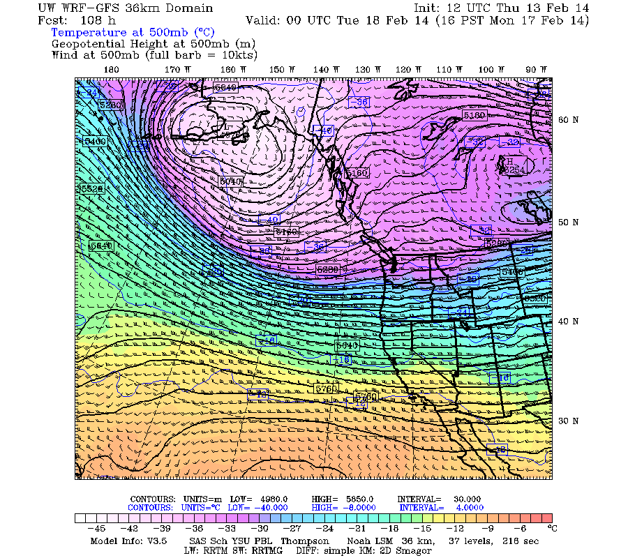
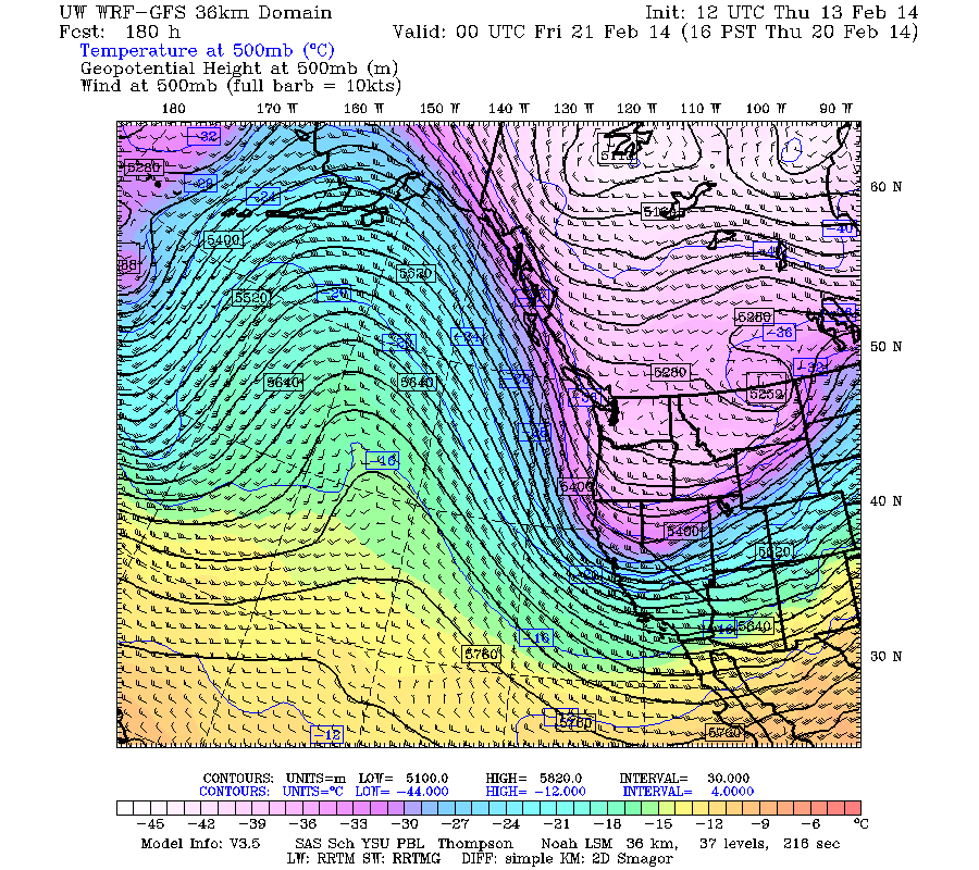
What about the longer term? A definite end to this storm cycle is not yet certain, but it appears likely that the parent low in the Gulf of Alaska may fade away by next Thursday, replaced by a ridge of high pressure building far out there over the North Pacific. That would bring the daily parade of storm systems to an end along with the heavy snowfall. It's easiest to see this process in the 36 km, 500 mb temp-winds-heights loop ( www.atmos.washington.edu/~ovens/wxloop.c..._500t+2014021312///3 ). These three frames from that loop show the current upper low in the Gulf of Alaska, a still-active and strong low 4 days from now on Monday, and then the low completely vanished 7 days from now next Thursday, replaced by an upper-level ridge:
But unlike after the first major storm cycle of the 2013-14 season (January 7-14, 2014) , there are no indications of a sustained period of high pressure and fair weather over the entire West Coast after this much-larger storm cycle. The extended GFS model out to 384 hours (16 days) shows additional weaker storm systems throughout the 8-16 day period. This is the predicted 24-hour precip throughout that period, click "Loop All" to see all the graphics (3 hour intervals up to 192 hours, 12 hour intervals beyond that):
GFS, North Pacific, 02/13/2014 12UTC, precip_p24
[hr]Primary data sources for the table below (numerous sites):
USDA NRCS SNOTEL (easily view data: SNOTEL Data Viewer Script )
Northwest Avalanche Center (easily view data: NWAC Data Viewer Script )
California Cooperative Snow Surveys
British Columbia River Forecast Centre (easily view data: British Columbia Snow Telemetry )
National Climatic Data Center
Environment Canada Climate Data
Supplementary data sources (one or a few sites):
Whistler Blackcomb Ski Resort
Mount Washington Alpine Resort
Hoodoo Ski Resort
Mount Bachelor Ski Resort
Crater Lake National Park
Mount Shasta Avalanche Center
Mammoth Mountain Ski Area
with an additional 4-8 ft of snow (or more) predicted over the next week for WA, OR, and southwest BC!
Another day later, and 2 more subsequent runs of the UW WRF-GFS model at 12-hour intervals continue to predict large snowfall amounts of 4-8 ft (and perhaps much more) over the next week for Washington, Oregon, and southwest BC, along with about 3-5 ft in northern California. This is in addition to 2-6 ft of snow which has already fallen over the past 7 days at most mountain sites from Bella Coola, BC, all the way south to Mammoth Mountain, a span of about 1100 miles as the crow flies (and well over 1500 miles by car). The predicted amounts for both precip and snowfall over the next week remain similar to those predicted during the last 3-5 days, a good sign of stability in the model's predictions, with a continuing increase in overall totals as further storm systems come into view this weekend and into next week. If these predictions verify and the storm cycle continues as expected for another week, this will end up solidly in the HUGE storm cycle category with 10-day snowfall totals exceeding 10 ft at many sites especially above 4000-5000 ft in the Washington and northern Oregon Cascades plus southwestern BC.
The first stage of this storm cycle, aimed primarily at the Sierra Nevada (an atmospheric river) and also at Oregon and southern Washington (frontal snowfall along the boundary between a modified Arctic air mass and warmer air to the south), began early on Thursday, February 6, and ended during the day Monday, February 10. The second stage of this storm cycle started early Monday morning and will extend throughout this weekend into next week, featuring a series of fronts and systems every 1-2 days in strong westerly and southwesterly flow over the north Pacific, aimed primarily at Oregon, Washington, and southwestern British Columbia. The first system of the second stage came ashore Monday morning, and the next much stronger system arrived in the same region on Tuesday afternoon, including another atmospheric river event aimed at Oregon, a few hundred miles farther north than the first atmospheric river aimed at the central Sierra Nevada. This atmospheric river is expected to stay in place for another 2-3 days while slowly shifting southward, weakening slightly today and more significantly by Saturday afternoon as it eventually shifts a couple hundred miles farther south into northern California, which will bring some more precipitation to that area over the weekend, before it finally fades away on Sunday.
The NWS's GFS model and their Quantitative Precipitation Forecasts continue to show up to 8-16" of precip over the next week for the mountains of southwestern BC, Washington, Oregon, and northwestern California, with much smaller amounts of only 1-3" extending farther south into the northern Sierra. Here is total precipitation in inches predicted over the next 7 days through the afternoon of Thursday, February 20:
The fire hose of the jet stream (see Days 1-5 Jet Stream Analysis & Forecasts ) will be aimed directly into the Pacific Northwest the rest of this week and into the middle of next week, still peaking in intensity at almost 190 knots (about 220 mph) today. Here is the jet stream for 4pm Thursday afternoon:
By Sunday the jet stream pattern is expected to have evolved and shifted, now approaching directly from the west, and remain that way through Tuesday, February 18 -- a much better direction for large snowfall totals at much lower snow levels:
Following a minor lull between systems during the day Wednesday in Washington (not much of a lull in Oregon), the next slightly cooler system arrived later Wednesday evening and overnight through Thursday. The system Wednesday night again featured very high winds, with maximum gusts of over 100 mph at Mission Ridge, White Pass, and Mt Hood Meadows (Top of Cascade Express), and over 90 mph atop Alpental.
As of Thursday morning, February 13, another 3-12" of new snow has fallen over the previous 24 hours at higher elevations throughout the Washington and northern Oregon Cascades, Olympics, and southwestern BC extending north past Whistler. Snow levels overnight into early Thursday were about 3000 ft near Whistler, 4000 ft in the North Cascades, 4500 ft near Stevens and Snoqualmie Passes, 5000 ft from Crystal and Mount Rainier south to White Pass, 6000 ft in the northern Oregon Cascades, and 7000 ft in the southern Oregon Cascades, but were already beginning to drop quickly by Thursday morning. This time the largest snowfall amounts were about 12" new at Brown Top SNOTEL (North Cascades) and Washington Pass, 10" in Mazama, about 9-12" at the Squamish River (4550 ft, west of Whistler), Spuzzum Creek (3950 ft, east of Harrison Lake), and Chilliwack River (5300 ft in the BC Cascades just north of the US border) BCRFC sites, 9" at Mount Washington (4500 ft) on Vancouver Island (which reopens today after being closed for the past 2 weeks due to insufficient snowpack), over 10" atop Alpental, and 9-11" at Mount Bachelor (6300 and 7300 ft). Mount Hood received over 2" of precipitation with about 3" new snow at Timberline at 5900 ft, but snowfall amounts of 1-1.5 ft were likely above 6500 ft.
Throughout the Cascade Range, Olympics, and southwestern BC, snow totals thus far since the storm cycle began early on February 6 range from 2 ft at the Burnt Bridge Creek BCRFC site (4400 ft, east of Bella Coola), 3 ft at Squamish River , 2 ft at Whistler, 3.5 ft at Spuzzum Creek , 3 ft at Mount Washington on Vancouver Island, 1.5 ft at Hurricane Ridge and 2.5 ft at Buckinghorse SNOTEL in the Olympics, 3 ft at Mount Baker, 3.5 ft at Brown Top SNOTEL and Washington Pass, 2-3 ft in much of the North Cascades, 3 ft at Stevens Pass, 2 ft at Snoqualmie Pass (with 4 ft atop Alpental), 1.5 ft at Mission Ridge, 2-2.5 ft at Crystal, 3 ft at Mount Rainier Paradise, 3.5 ft at White Pass, 4 ft at Mount Hood (with perhaps 6 ft above 7000 ft), 2.5 ft at Santiam Pass, 5-5.5 ft on Mount Bachelor, 3 ft at Willamette Pass, 2.5-3 ft at Crater Lake, 1.5-2.5 ft on Mount Shasta, and roughly 2-4 ft on Lassen Peak (actual totals there are unknown due to a long-term outage at the 8250 ft Lake Helen telemetry site, plus the complete wintertime closure of the visitor center at the park's 6700 ft southwest entrance due to budget concerns, where daily snowfall measurements are normally taken). In the Sierra Nevada, snowfall totals as of the end of the first stage of this storm cycle on February 10 were about 5-7 ft at many ski area upper stations near Lake Tahoe above 8000 ft, with more like 1-2 ft total at the 6000 ft level. Areas farther south such as Yosemite and Mammoth received much less snowfall, only about 2-3 ft even at 9000 ft, and only 2" total at 9000 ft on June Mountain located just north of Mammoth in the rain shadow of the Sierra Crest. See the table in the next post below for more complete snow and precip totals at over 180 measurement sites.
[size=small]The Mountain comes out AGAIN on Thursday afternoon during a lull between systems, but no lenticular this time unlike yesterday.[/size]
There is another minor lull between systems on Thursday afternoon and evening, then the next stronger system arrives by midnight and continues through Friday. Yet more systems are in the pipeline for Saturday afternoon and Sunday afternoon. The current stage of this storm cycle is also producing heavy snowfall in southeast Alaska, today and again over the weekend, all due to various low-pressure systems spawned from the same parent low in the Gulf of Alaska which has been associated with this entire storm cycle. Here is a wider view from the 36km resolution, showing several feet of snowfall in southeast Alaska through Sunday:
[size=small](This is actually model snow precip and not snowfall, but that distinction is unimportant for this image.)[/size]
Snowfall during the next 3 days through 4pm Sunday is predicted to be 3-5 ft over the west slopes and volcanic peaks of the Washington and northern Oregon Cascades, the Olympics, and southwestern BC, with perhaps up to 1 ft extending into the California Cascades and northern Sierra Nevada on Saturday and Sunday:
Higher resolution version of that, showing the Pacific Northwest and also zoomed in on Washington and Oregon:
Maximum snowfall amounts of 4-5 ft (marked by white inside yellow) are shown along the west slopes of the Olympics and the volcanic peaks of the Washington and Oregon Cascades. In Oregon, even Newberry Volcano and Yamsay Mountain (another large shield volcano east of Crater Lake, the highest volcano in the eastern Cascade chain at 8196 ft) are shown with 3-4 ft expected, shocking given that both are 30 miles east of the Cascade Crest and normally quite rain-shadowed! Some major volcanoes have been labeled on the last graphic for clarity.
This loop shows how the model predictions for snowfall during the 3-day period through 4pm Sunday have evolved between 8 subsequent runs over the last 4 days, the D(model)/D(t). Very consistent in the overall picture throughout, with snowfall amounts increasing and decreasing a bit, but no major changes except for a trend towards more snowfall in the California Cascades on the latest runs:
www.atmos.washington.edu/~ovens/wxloop.c...2+v2014021700///+-st
Additional snowfall during the subsequent 3 days ending 4pm next Wednesday is predicted to be another 3-6 ft over the west slopes and volcanic peaks of the Washington and Oregon Cascades plus the Olympics, with 2-3 ft extending north into southwestern BC and south into the California Cascades and Trinity Alps. These systems from Sunday through early next week are also likely to feature somewhat lower snow levels than the systems thus far this week.
Beyond that point, it appears that this storm cycle is likely to continue to bring additional systems ashore every 1-2 days through next Thursday or Friday. Additional snowfall during the 1 day period ending 4pm next Thursday is predicted to be 1-2 ft over the Washington, Oregon, and California Cascades, along with the Klamath Mountains and much of the Sierra Nevada.
Details may certainly change as that period draws closer, as it is currently 6-7 days out, near the limit of accurate numerical weather prediction. But it puts the predicted 7.5-day snowfall totals (once again!) at roughly 7-14 ft (!!) over the west slopes and volcanic peaks of the Washington and Oregon Cascades, with about 5-10 ft in the Olympics, 4-8 ft in southwestern BC, and perhaps 3-5 ft in the California Cascades and northern Sierra Nevada, all of that on top of the 2-6 ft that have already fallen. Tremendous!
What about the longer term? A definite end to this storm cycle is not yet certain, but it appears likely that the parent low in the Gulf of Alaska may fade away by next Thursday, replaced by a ridge of high pressure building far out there over the North Pacific. That would bring the daily parade of storm systems to an end along with the heavy snowfall. It's easiest to see this process in the 36 km, 500 mb temp-winds-heights loop ( www.atmos.washington.edu/~ovens/wxloop.c..._500t+2014021312///3 ). These three frames from that loop show the current upper low in the Gulf of Alaska, a still-active and strong low 4 days from now on Monday, and then the low completely vanished 7 days from now next Thursday, replaced by an upper-level ridge:
But unlike after the first major storm cycle of the 2013-14 season (January 7-14, 2014) , there are no indications of a sustained period of high pressure and fair weather over the entire West Coast after this much-larger storm cycle. The extended GFS model out to 384 hours (16 days) shows additional weaker storm systems throughout the 8-16 day period. This is the predicted 24-hour precip throughout that period, click "Loop All" to see all the graphics (3 hour intervals up to 192 hours, 12 hour intervals beyond that):
GFS, North Pacific, 02/13/2014 12UTC, precip_p24
[hr]Primary data sources for the table below (numerous sites):
USDA NRCS SNOTEL (easily view data: SNOTEL Data Viewer Script )
Northwest Avalanche Center (easily view data: NWAC Data Viewer Script )
California Cooperative Snow Surveys
British Columbia River Forecast Centre (easily view data: British Columbia Snow Telemetry )
National Climatic Data Center
Environment Canada Climate Data
Supplementary data sources (one or a few sites):
Whistler Blackcomb Ski Resort
Mount Washington Alpine Resort
Hoodoo Ski Resort
Mount Bachelor Ski Resort
Crater Lake National Park
Mount Shasta Avalanche Center
Mammoth Mountain Ski Area
Please Log in or Create an account to join the conversation.
- Amar Andalkar
-
Topic Author
- User
-
Less
More
- Posts: 635
- Thank you received: 0
12 years 2 months ago - 12 years 2 months ago #220357
by Amar Andalkar
Replied by Amar Andalkar on topic Re: Next major storm brings 4-6 ft snow Feb 6-14,2014!
Table of total snowfall and precip, February 6-13, 2014:
This table shows the total snowfall and precip over the 7 day period from February 6 through Thursday afternoon, February 13, along with the increase in snowdepth from February 6 up to the maximum depth reached during this storm cycle thus far (most maxima occurred on February 8, 9, or 10 in CA and OR, but February 12 or 13 farther north). Some amounts are estimated and approximate, including all snowfall totals at SNOTEL, BCRFC, and CCSS sites (they have only a total snowdepth sensor, not a 24-hour snowfall sensor like most NWAC sites).
[tt]
Increase in
Total Snowdepth Total
Measurement Site Elevation Snowfall Feb6 >>> Max Precip Notes
==== British Columbia ====
---- Coast Mountains
Burnt Bridge Creek BCRFC 4360 ft 2 ft 55" >>> 75" 2" (way north, E of Bella Coola)
Tenquille Lake BCRFC 5480 ft 1.5 ft 53" >>> 67" 1.5" (N of Whistler, all snow)
Pemberton Airport 670 ft 1 ft 2" >>> 14" 1.2"
Whistler Village 2200 ft 1.5 ft 5" >>> 21" 1.5" (incomplete data)
Blackcomb Sliding Center 3100 ft 1.5 ft 16" >>> 31" 1.5"
Whistler Mountain 5400 ft 2 ft 50" >>> 70" --
Callaghan Valley 2900 ft 2.5 ft 21" >>> 48" 5" (W of Whistler)
Squamish River BCRFC 4550 ft 3 ft 57" >>> 85" 3.5" (W of Whistler, all snow)
Spuzzum Creek BCRFC 3930 ft 3.5 ft 50" >>> 83" 4" (E of Harrison Lake)
BC Cascades
Chilliwack River BCRFC 5320 ft 4 ft 97" >>> 124" 6"?? (NE of Mt Baker, all snow)
Hope Slide 2260 ft 1 ft 4" >>> 9" 2" (on Hwy 3, SE of Hope)
Blackwall Peak BCRFC 6350 ft 3 ft 54" >>> 77" 3" (Manning Park, all snow)
---- Vancouver Island ----
Mount Washington 4460 ft 3 ft 24" >>> 48" -- (W of Courtenay)
Jump Creek BCRFC 3720 ft 3 ft 14" >>> 33" 4.5" (N of Cowichan Lake)
======= Washington =======
--- Olympic Mountains ----
Hurricane Ridge 5250 ft 1.5 ft 31" >>> 44" 2"
Waterhole SNOTEL 5010 ft 2 ft 31" >>> 49" 3" (N side of Olympics)
Buckinghorse SNOTEL 4870 ft 3 ft 29" >>> 53" 6" (central Olympics)
Mount Crag SNOTEL 3960 ft 1.5 ft 13" >>> 27" 2.5" (E side of Olympics)
Cascade Range
Mt Baker, MF Nooksack SNOTEL 4970 ft 2 ft 78" >>> 89" 3.5" (NW side of Mt Baker)
Mt Baker Ski Area 4200 ft 3 ft 80" >>> 104" 4" (snowdepth flaky +/- 5")
Mt Baker, Marten Ridge SNOTEL 3520 ft 3 ft 54" >>> 75" 5" (E side of Mt Baker)
Mt Baker, Elbow Lake SNOTEL 3040 ft 2 ft 31" >>> 42" 5" (SW side of Mt Baker)
Brown Top SNOTEL 5830 ft 3.5 ft 79" >>> 110" 4" (E of Mox Peaks, all snow)
Beaver Pass SNOTEL 3630 ft 3 ft 40" >>> 65" 4"
Thunder Basin SNOTEL 4320 ft 2 ft 39" >>> 55" 3.5" (N of Mt Buckner)
Park Creek Ridge SNOTEL 4600 ft 3.5 ft 46" >>> 73" 5" (SE ridge of Mt Buckner)
Swamp Creek SNOTEL 3930 ft 2 ft 38" >>> 55" 3" (Hwy 20, W of Rainy Pass)
Rainy Pass SNOTEL 4890 ft 3.5 ft 44" >>> 74" 4" (almost all snow)
Washington Pass 5450 ft 3.5 ft 49" >>> 79" -- (all snow)
Harts Pass SNOTEL 6500 ft 3 ft 57" >>> 81" 3" (all snow)
Mazama 2200 ft 2.5 ft 10" >>> 31" 2"
Stehekin 1250 ft 2 ft 4" >>> 20" 3"
Holden Village 3220 ft 2.5 ft 20" >>> 39" 3"
Lyman Lake SNOTEL 5980 ft 3 ft 76" >>> 99" 3" (almost all snow)
Trinity SNOTEL 2930 ft 3.5 ft 38" >>> 62" 5"
Alpine Meadows SNOTEL 3500 ft 1 ft 46" >>> 53" 4" (Tolt River headwaters)
Stevens Pass, Skyline 5250 ft 3 ft 82" >>> 98" 5" (precip from 4370 ft)
Stevens Pass, Grace Lakes 4800 ft 3 ft 85" >>> 107" --
Stevens Pass NWAC 3950 ft 3 ft 59" >>> 76" 4"
Stevens Pass SNOTEL 3950 ft 3 ft 62" >>> 79" 4.5"
Berne Snow Camp 2700 ft 1.5 ft 13" >>> 27" 3.5"
Lake Wenatchee 1930 ft 1.5 ft 7" >>> 21" 2.5"
Leavenworth 1130 ft 1.5 ft 4" >>> 16" 2"
Sasse Ridge SNOTEL 4340 ft 3 ft 49" >>> 67" 4.5" (E of Salmon La Sac Rd)
Blewett Pass SNOTEL 4240 ft 1.5 ft 21" >>> 32" 3" (near old Blewett Pass)
Blewett Pass NWAC 4100 ft 1 ft 13" >>> 21" 1"xx (precip gage not heating)
Grouse Camp SNOTEL 5390 ft 1.5 ft 28" >>> 41" 2.5" (between Blewett & Mission)
Mission Ridge 5160 ft 1.5 ft 22" >>> 35" 2"
Top of Alpental 5470 ft 4 ft 107" >>> 127" -- (snowdepth may be suspect?)
Alpental Base 3100 ft 2 ft 51" >>> 68" 6"
Snoqualmie Pass 3000 ft 2 ft 42" >>> 60" 6"
Stampede Pass SNOTEL 3850 ft 2 ft 37" >>> 52" 6"
Corral Pass SNOTEL 5800 ft 2 ft 50" >>> 63" 3.5" (N of Crystal Mtn)
Crystal Mtn, Green Valley 6230 ft 2.5 ft 66" >>> 83" --
Crystal Mtn Base 4570 ft 2 ft 26" >>> 39" 2.5"
Morse Lake SNOTEL 5400 ft 3 ft 51" >>> 76" 4.5" (just S of Crystal Mtn)
Cayuse Pass SNOTEL 5240 ft 2.5 ft 55" >>> 76" 4" (on SR 410 above Cayuse Pass)
Mt Rainier, Sunrise 6400 ft 2 ft 43" >>> 56" --
Mt Rainier, Paradise 5400 ft 3 ft 99" >>> 117" 3.5"
Mt Rainier, Paradise SNOTEL 5130 ft 3 ft 90" >>> 109" 5" (SW of Paradise)
Mt Rainier, Longmire 2700 ft 0.7 ft 6" >>> 12" 1"
Bumping Ridge SNOTEL 4610 ft 2.5 ft 34" >>> 51" 3.5" (SE of Chinook Pass)
White Pass Ski Area (top) 5800 ft 3 ft 85" >>> 105" 4"
Pigtail Peak SNOTEL 5800 ft 3 ft 84" >>> 104" 5" (top of White Pass Ski Area)
White Pass E.S. SNOTEL 4440 ft 2 ft 28" >>> 42" 4"
Green Lake SNOTEL 5920 ft 2.5 ft 39" >>> 55" 3" (E of Goat Rocks)
Lost Horse SNOTEL 5120 ft 2 ft 16" >>> 32" 2.5" (NE of Mt Adams)
Mt Adams, Potato Hill SNOTEL 4510 ft 2 ft 41" >>> 53" 4" (N side of Mt Adams)
Mt Adams RS, Trout Lake 1950 ft 1.5 ft 2" >>> 13" 3" (incomplete data)
Surprise Lakes SNOTEL 4290 ft 3 ft 43" >>> 61" 6" (Indian Heaven, SW of Adams)
Mt St Helens, Spirit Lake 3520 ft 0.5 ft 7" >>> 9" 3.5" (windswept & rain-shadowed)
Mt St Helens, Swift Creek 4440 ft 3 ft 40" >>> 55" 6" (S side of Mt St Helens)
Mt St Helens, Sheep Canyon 3990 ft 2 ft 31" >>> 40" 6" (W side of Mt St Helens)
Mt St Helens, June Lake 3440 ft 2 ft 30" >>> 41" 7" (SE side of Mt St Helens)
Indian Rock SNOTEL 5360 ft 2.5 ft 17" >>> 34" 5" (W of Satus Pass)
Satus Pass SNOTEL 3960 ft 1.5 ft 11" >>> 24" 3" (at former ski area site)
========= Oregon =========
Cascade Range
Blazed Alder SNOTEL 3650 ft 2 ft 29" >>> 40" 8.5" (NW of Mt Hood)
Mt Hood, Red Hill SNOTEL 4410 ft 3 ft 39" >>> 59" 9" (N side of Mt Hood)
Mt Hood, Timberline Lodge 5880 ft 4 ft 76" >>> 97" 11"
Mt Hood, Test Site SNOTEL 5370 ft 3 ft 67" >>> 85" 8" (just S of Timberline)
Mt Hood, Meadows Ski Area 5380 ft 3.5 ft 58" >>> 81" 10"
Mt Hood, Government Camp 3980 ft data not yet received at NCDC (S side of Mt Hood)
Mt Hood Ski Bowl (prec 3660) 5010 ft 2.5 ft 28" >>> 46" 7" (snowdepth flaky +/- 5")
Mud Ridge SNOTEL 4070 ft 2 ft 26" >>> 41" 6" (S of Mt Hood)
Hogg Pass SNOTEL 4790 ft 3 ft 19" >>> 42" 6" (at Santiam Pass)
Hoodoo Ski Area 5010 ft 3 ft 26" >>> 51" --
Sisters 3180 ft 1.5 ft 7" >>> 18" 3" (incomplete data)
Bear Grass SNOTEL 4720 ft 3 ft 33" >>> 58" 10" (W of Mt Washington)
McKenzie SNOTEL 4770 ft 3 ft 40" >>> 67" 11.5" (near Obsidian Trailhead)
Three Creeks Meadow SNOTEL 5690 ft 3 ft 18" >>> 41" 8" (E of Three Sisters)
Mt Bachelor, Mid-Mountain 7300 ft 5.5 ft 74" >>> 120" -- (top of Sunrise Express)
Mt Bachelor, West Village 6300 ft 5 ft 64" >>> 91" --
Irish Taylor SNOTEL 5540 ft 3 ft 41" >>> 66" 6.5" (SW of Mt Bachelor)
Cascade Summit SNOTEL 5100 ft 3 ft 32" >>> 54" 7.5" (just S of Willamette Pass)
New Crescent Lake SNOTEL 4910 ft 2.5 ft 9" >>> 26" 7" (E of Diamond Peak)
Diamond Peak, Summit Lake 5610 ft 3 ft 27" >>> 52" 5" (S side of Diamond Peak)
Diamond Lake SNOTEL 5280 ft 1.5 ft 4" >>> 12" 7" (extreme rain-shadowed site)
Silver Creek SNOTEL 5740 ft 1.5 ft 4" >>> 18" 3.5" (NE flank of Yamsay Mtn)
Crater Lake, Rim 7050 ft 3 ft 35" >>> 61" -- (S rim of caldera)
Crater Lake, Park HQ 6470 ft 2.5 ft 16" >>> 41" -- (S of caldera rim)
Crater Lake, Lagoon 6370 ft ? ft 30" >>> ??" 5" (near Park HQ)
Crater Lake, Annie Springs 6000 ft 2.5 ft 19" >>> 38" 6.5" (near S entrance of Park)
Sevenmile Marsh SNOTEL 5700 ft 2.5 ft 13" >>> 29" 7.5" (S of Crater Lake)
Pelican Butte, Cold Springs 5940 ft 2 ft 16" >>> 27" 6" (NW side of Pelican Butte)
Mt McLoughlin, Fourmile Lake 5970 ft 2 ft 13" >>> 25" 6" (E side of Mt McLoughlin)
Mt McLoughlin, Billie Creek 5280 ft 1.5 ft 15" >>> 22" 4.5" (SE side of Mt McLoughlin)
Mt McLoughlin, Fish Lake 4660 ft 0.5 ft 7" >>> 10" 3" (SW side of Mt McLoughlin)
Swan Lake Mtn SNOTEL 6830 ft 1.5 ft 8" >>> 16" 3.5" (NE of Klamath Falls)
--- Siskiyou Mountains ---
Big Red Mountain SNOTEL 6050 ft 0.5 ft 2" >>> 7" 3" (SW of Ashland)
======= California =======
Cascade Range
Medicine Lake 6700 ft 1.5 ft 0" >>> 13" 3" (in Med Lake Volcano caldera)
Mt Shasta, Old Ski Bowl 7600 ft 2.5 ft 4" >>> 26" 3" (S side of Mt Shasta)
Mt Shasta, Sand Flat 6750 ft 1.5 ft 2" >>> 16" 3" (SW side of Mt Shasta)
Stouts Meadow (Grizzly Peak) 5400 ft 2 ft 4" >>> 22" 8.5" (SE of Mt Shasta and McCloud)
Snow Mountain 5950 ft 1.5 ft 0" >>> 10" 9" (between Shasta and Lassen)
Blacks Mountain 7050 ft 1.5 ft 0" >>> 10" 2.5" (well NE of Lassen Peak)
Lassen Peak, Lake Helen 8250 ft data outage, depth 12" on Jan28 (SW side of Lassen Peak)
Lassen, Harkness Flat 6200 ft 1.5 ft 0" >>> 16" -- (well E of Lassen Peak)
Humbug 6500 ft 1 ft 0" >>> 8" 6" (SW of Lake Almanor)
--- Klamath Mountains ----
Mt Eddy, NE side 6510 ft 1 ft 0" >>> 10" -- (W of Shasta across I-5)
Mt Eddy, Peterson Flat 7150 ft 2 ft 0" >>> 17" 3.5" (SW side of Mt Eddy)
Scott Mountain 5900 ft 1 ft 0" >>> 6" 4" (W of Mt Eddy)
Mumbo Basin 5650 ft 2 ft 0" >>> 14" 4" (S of Mt Eddy)
Big Flat 5100 ft 1 ft 0" >>> 7" 3.5" (NW of Trinity Lake)
Red Rock Mountain 6700 ft 2 ft 2" >>> 19" -- (NW of Trinity Lake)
Shimmy Lake 6400 ft 2 ft 0" >>> 15" -- (NW of Trinity Lake)
Bonanza King 6450 ft 2 ft 0" >>> 15" 4" (N of Trinity Lake)
Highland Lakes 6030 ft 2 ft 0" >>> 18" 5.5" (NE of Trinity Lake)
Slate Creek 5700 ft 1.5 ft 0" >>> 12" 5" (NE of Trinity Lake)
Sierra Nevada
Rattlesnake 6100 ft 0.5 ft 0" >>> 4" 2.5" (SE of Lake Almanor)
Kettle Rock 7300 ft 1.5 ft 0" >>> 10" 3" (well SE of Lake Almanor)
Bucks Lake 5750 ft 2 ft 0" >>> 18" 12" (NE of Lake Oroville)
Four Trees 5150 ft 2.5 ft 0" >>> 22" 17" (NE of Lake Oroville)
Pilot Peak 6800 ft 1.5 ft 0" >>> 12" 5" (S of SR 70 & Quincy)
Robinson Cow Camp 6480 ft 1.5 ft 0" >>> 13" 6" (N of SR 49 & Sierra City)
Meadow Lake 7200 ft 3 ft 20" >>> 47" -- (N of I-80, MP 168)
Independence Lake SNOTEL 8350 ft 5 ft 15" >>> 50" 7" (N of I-80, MP 180)
Central Sierra Snow Lab 6850 ft 3 ft 14" >>> 34" 10" (along I-80, MP 174)
Huysink 6600 ft 2 ft 9" >>> 21" 16" (S of I-80, MP 165)
Blue Canyon 5280 ft 1.5 ft 0" >>> 14" 13" (along I-80, MP 155)
Big Meadow SNOTEL (Nevada) 8250 ft 2.5 ft 14" >>> 31" 3" (S of I-80, Nevada MP 3)
Mt Rose Ski SNOTEL (Nevada) 8800 ft 5 ft 22" >>> 58" 8" (along SR 431, Nevada)
Marlette Lake SNOTEL (Nevada) 7880 ft 4 ft 22" >>> 53" 6.5" (E of Lake Tahoe, Nevada)
Squaw Valley G.C. SNOTEL 8030 ft 6 ft 13" >>> 60" 11" (Squaw Valley Ski Area)
Ward Creek #3 SNOTEL 6650 ft 1.5 ft 13" >>> 23" 12" (S of Alpine Mdws Ski Area)
Greek Store 5600 ft 1.5 ft 4" >>> 19" 12" (well W of Lake Tahoe)
Rubicon #2 SNOTEL 7700 ft 1.5 ft 17" >>> 27" 6" (W of Lake Tahoe above SR 89)
Heavenly Valley SNOTEL 8580 ft 5 ft 18" >>> 52" 6" (bottom of Sky Express)
Hagan's Meadow SNOTEL 7780 ft 1.5 ft 12" >>> 25" 5" (W side of Freel Peak)
Horse Meadow SNOTEL 8550 ft 5 ft 15" >>> 52" 6" (SE side of Freel Peak)
Echo Peak SNOTEL 7670 ft 6 ft 22" >>> 66" 10" (W of Echo Summit, US 50)
Forni Ridge 7600 ft 4 ft 10" >>> 40" 9" (US 50, W of Sierra-at-Tahoe)
Silver Lake 7100 ft 2 ft 13" >>> 28" 8" (SR 88, W of Kirkwood)
Caples Lake 8000 ft 4.5 ft 13" >>> 44" 6" (SR 88, E of Kirkwood)
Carson Pass SNOTEL 8350 ft 5 ft 21" >>> 57" 6" (SR 88, E of Kirkwood)
Forestdale Creek SNOTEL 8020 ft 5.5 ft 21" >>> 61" 8" (just E of Carson Pass)
Burnside Lake Creek SNOTEL 8130 ft 4.5 ft 17" >>> 53" 5.5" (E of Carson Pass)
Monitor Pass SNOTEL 8310 ft 1 ft 17" >>> 22" 1" (way E on SR 89)
Blue Lakes SNOTEL 8050 ft 3 ft 17" >>> 43" 7.5" (SE of Carson Pass)
Ebbetts Pass SNOTEL 8770 ft 5 ft 29" >>> 63" 6.5" (along SR 4)
Stanislaus Meadow 7750 ft 6 ft 15" >>> 67" 8" (SR 4, SW of Ebbetts Pass)
Bloods Creek 7200 ft 4 ft 17" >>> 51" -- (SR 4, S of Bear Valley)
Black Springs 6500 ft 1.5 ft 6" >>> 16" 9.5" (SR 4, NE of Arnold)
Lobdell Lake SNOTEL 9230 ft 1 ft 12" >>> 19" 1" (way E of US 395)
Deadman Creek 9250 ft 3 ft 24" >>> 47" 3.5" (SR 108, W of Sonora Pass)
Sonora Pass SNOTEL 8830 ft 2.5 ft 20" >>> 39" 3" (SR 108, E of Sonora Pass)
Leavitt Lake SNOTEL 9620 ft 4.5 ft 42" >>> 73" 5.5" (S of Sonora Pass)
Gianelli Meadow 8400 ft 5 ft 24" >>> 61" 8" (E of Dodge Ridge Ski Area)
Slide Canyon 9200 ft 4 ft 32" >>> 66" -- (NE part of Yosemite NP)
Paradise Meadow 7650 ft 3 ft 8" >>> 33" 7" (N part of Yosemite NP)
Virginia Lakes Ridge SNOTEL 9450 ft 1 ft 15" >>> 22" 1" (NE of Yosemite near US 395)
Tenaya Lake 8150 ft 2.5 ft 20" >>> 37" 3" (on SR 120 in Yosemite NP)
Tuolumne Meadows 8600 ft 1.5 ft 10" >>> 21" 2"
Please Log in or Create an account to join the conversation.
- Amar Andalkar
-
Topic Author
- User
-
Less
More
- Posts: 635
- Thank you received: 0
12 years 2 months ago - 12 years 2 months ago #220371
by Amar Andalkar
Replied by Amar Andalkar on topic Re: Next major storm brings 4-6 ft snow Feb 6-14,2014!
Update #8: 192 hours after initial post, 2-7 ft of snow has already fallen in southwest BC, Washington, Oregon, and California,
with an additional 4-8 ft (or more) predicted over the next week for WA, OR, and southwest BC!
The climax of this storm cycle is about to arrive in the Pacific Northwest! The period of maximum sustained snowfall for Washington and Oregon is expected to extend from Sunday into the middle of next week...
Another day later, and 2 more subsequent runs of the UW WRF-GFS model at 12-hour intervals continue to predict large snowfall amounts of 4-8 ft (and perhaps much more) over the next week for Washington, Oregon, and southwest BC, along with about 3-5 ft in northern California. This is in addition to 2-7 ft of snow which has already fallen over the past 8 days at most mountain sites from Bella Coola, BC, all the way south to Mammoth Mountain, a span of about 1100 miles as the crow flies (and well over 1500 miles by car). The predicted amounts for both precip and snowfall over the next week remain similar to those predicted during the last 3-6 days, almost monotonously and repetitively similar on each of the last few updates -- but that's an excellent sign of stability in the model's predictions, with a continuing increase in overall totals as further storm systems come into view this weekend and into next week. If these predictions verify and the storm cycle continues as expected for another week, this will end up solidly in the HUGE storm cycle category with 10-day snowfall totals exceeding 10 ft at many sites especially above 4000-5000 ft in the Washington and northern Oregon Cascades plus southwestern BC.
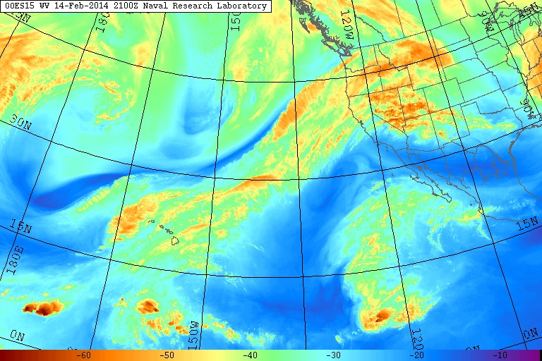
The first stage of this storm cycle, aimed primarily at the Sierra Nevada (an atmospheric river) and also at Oregon and southern Washington (frontal snowfall along the boundary between a modified Arctic air mass and warmer air to the south), began early on Thursday, February 6, and ended during the day Monday, February 10. The second stage of this storm cycle started early Monday morning and will extend throughout this weekend into next week, featuring a series of fronts and systems every 1-2 days in strong westerly and southwesterly flow over the north Pacific, aimed primarily at Oregon, Washington, and southwestern British Columbia. The first system of the second stage came ashore Monday morning, and the next much stronger system arrived in the same region on Tuesday afternoon, including another atmospheric river event aimed at Oregon, a few hundred miles farther north than the first atmospheric river aimed at the central Sierra Nevada. This atmospheric river is expected to stay in place for another 1-2 days while slowly shifting southward, weakening slightly today and more significantly by Saturday afternoon as it eventually shifts a couple hundred miles farther south into northern California, which will bring some more precipitation to that area over the weekend, before it finally fades away on Sunday. This event has already produced very high precipitation amounts exceeding 10" on Mount Hood in the last 4 days. The water vapor satellite image from Friday afternoon (see www.nrlmry.navy.mil/sat-bin/epac_westcoast.cgi ) shows the plume of moisture still aimed at Oregon, although less sharply defined than in the image from Update #6 two days earlier:
The NWS's GFS model and their Quantitative Precipitation Forecasts still show up to 8-11" of precip over the next week for the mountains of Washington, Oregon, and northwestern California, with 4-5" in southwestern BC and much smaller amounts of only 1-2" extending south into the northern Sierra. Here is total precipitation in inches predicted over the next 7 days through the afternoon of Friday, February 21:
Following another minor lull between systems on Thursday afternoon and evening, the current storm system arrived around midnight Thursday-Friday and will continue through Friday evening, most intensely in Oregon. As of midday Friday, February 14, another 4-14" of new snow has fallen over the previous 24 hours at higher elevations throughout the Washington and Oregon Cascades, Olympics, and southwestern BC extending north past Whistler, with heavy snowfall continuing at many sites into Friday afternoon. Snow levels rose somewhat overnight into midday Friday to about 3000 ft near Whistler, 4000 ft in the North Cascades, 4500 ft from Snoqualmie Pass to Mount Rainier, 5000 ft from White Pass through Mount Hood, 6000 ft in the central Oregon Cascades, and 7000 ft in the southern Oregon Cascades. The largest snowfall amounts are in the Oregon Cascades today, with around 1 ft of dense new snow as of noon at Timberline on Mount Hood and on Mount Bachelor, which continues to have the largest storm total snowfall of any measurement site in the Northwest with about 6.5 ft now. Given continued heavy snowfall throughout the day, there is no point in trying to update the storm totals at this time from the values listed above in the previous post.
There is yet another lull between systems on Friday night, then the next system arrives by Saturday afternoon into Sunday morning, followed quickly by another stronger system on Sunday afternoon through Monday. Another strong system is expected on Tuesday. The current stage of this storm cycle is also producing heavy snowfall in southeast Alaska, for the past day and again over the weekend, all due to various low-pressure systems spawned from the same parent low in the Gulf of Alaska which has been associated with this entire storm cycle. Here is a wider view from the 36km resolution, showing several more feet of snowfall in southeast Alaska through Monday:
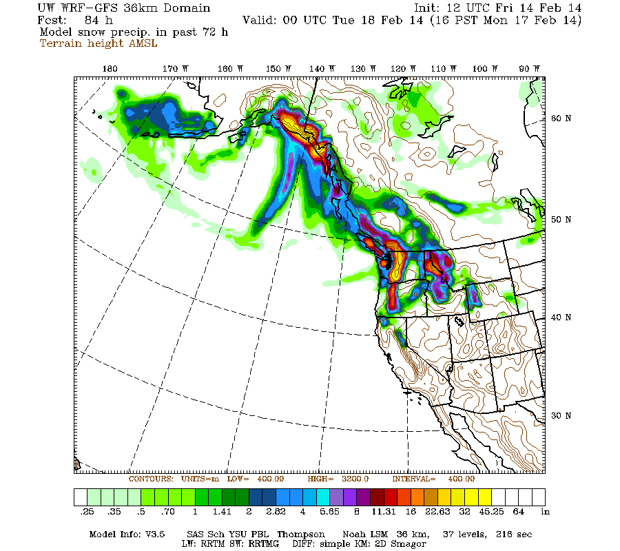
[size=small](This is actually model snow precip and not snowfall, but that distinction is unimportant for this image.)[/size]
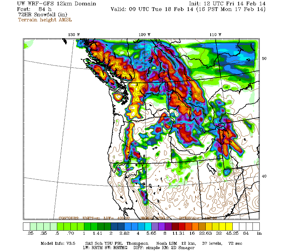
Snowfall during the next 3 days through 4pm Monday is predicted to be 3-7 ft over the west slopes and volcanic peaks of the Washington and Oregon Cascades, the Olympics, and southwestern BC, with perhaps up to 1-3 ft extending into the California Cascades, Trinity Alps, and northern Sierra Nevada on Saturday and Sunday:
Higher resolution version of that, showing the Pacific Northwest and also zoomed in on Washington and Oregon:
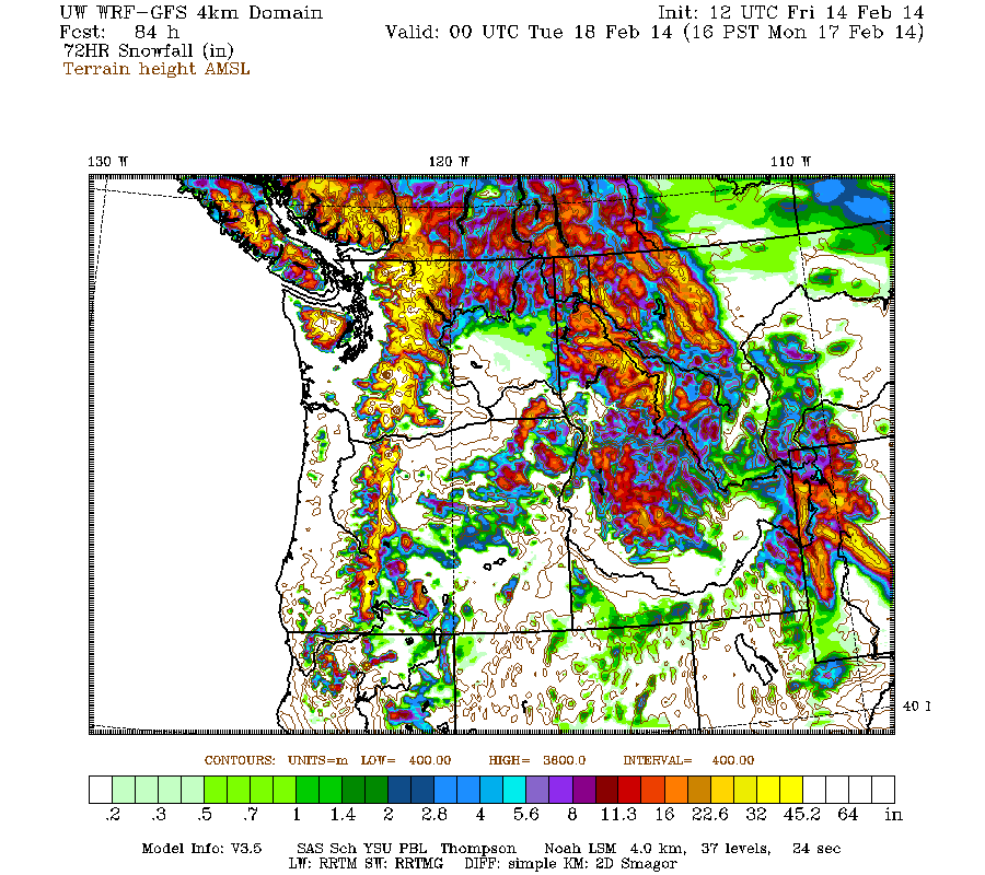
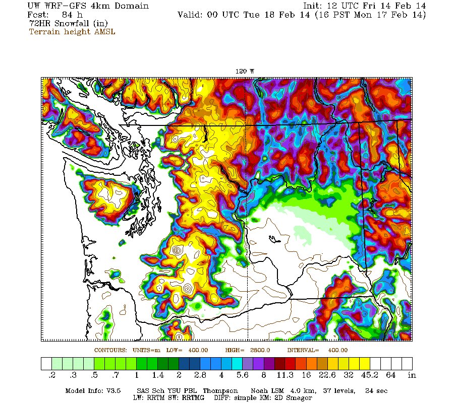
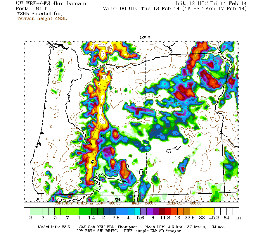
Maximum snowfall amounts of 4-7 ft (marked by white inside yellow) are shown along the west slopes and volcanic peaks of the Washington and Oregon Cascades plus the Olympics. Notably, the Washington graphic above has the largest area with 3-day totals over 4 ft shown in any 3-day graphic in any previous update in this thread, or either of the two earlier storm threads. So this is expected to be the largest 3-day snowfall in Washington state thus far in the 2013-14 season. The most intense portion of that is Sunday through early Monday, when even the 24-hour totals are predicted to exceed 4 ft on Mounts Rainier, Adams, and Saint Helens above about 5000 ft:

It will be very interesting to see if such an extreme snowfall prediction actually verifies, especially since that is currently 2-3 days out. The UW model has become very good over the past several years of development, but extreme predictions often tend not to actually occur, and real 24-hour snowfall amounts may end up in the more reasonable 2-3 ft range.
This loop shows how the model predictions for snowfall during the 3-day period through 4pm Monday have evolved between 10 subsequent runs over the last 5 days, the D(model)/D(t). Very consistent in the overall picture throughout, with snowfall amounts increasing and decreasing a bit especially in northern California, but no major changes:
www.atmos.washington.edu/~ovens/wxloop.c...2+v2014021800///+-st
Additional snowfall during the subsequent 3 days ending 4pm next Thursday is predicted to be another 3-6 ft over the west slopes and volcanic peaks of the Washington and Oregon Cascades, with 2-3 ft in the Olympics, southwestern BC, and extending south into the California Cascades, Trinity Alps, and northern Sierra Nevada. These systems from Sunday through early next week are also likely to feature somewhat lower snow levels than the systems thus far this week.
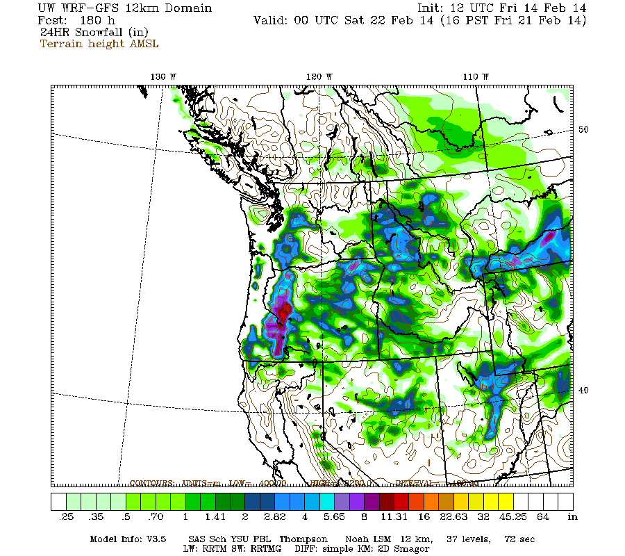
Beyond that point, it appears that this storm cycle is likely to include at least one more system next Thursday-Friday before it eventually tapers off. Additional snowfall during the 1 day period ending 4pm next Friday is predicted to be 1-2 ft over the Oregon Cascades, with less than 1 ft extending north into Washington. Details may certainly change as that period draws closer, as it is currently 6-7 days out, near the limit of accurate numerical weather prediction.
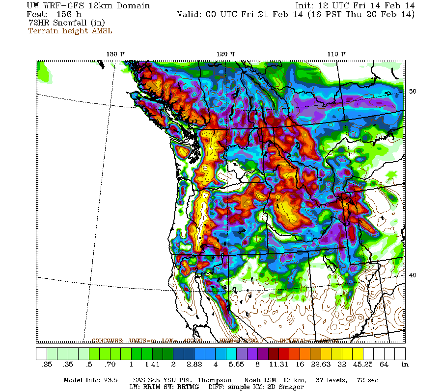
The predicted 7.5-day snowfall totals still remain astronomical at roughly 7-14 ft (!!) over the west slopes and volcanic peaks of the Washington and Oregon Cascades, with about 5-10 ft in the Olympics, 4-8 ft in southwestern BC, and perhaps 3-5 ft in the California Cascades and northern Sierra Nevada, all of that on top of the 2-7 ft that have already fallen. Fantastic!
It appears increasingly likely that this storm cycle will finally dissipate and come to an end roughly one week from now. But unlike after the first major storm cycle of the 2013-14 season (January 7-14, 2014) , there are no indications of a sustained period of high pressure and fair weather over the entire West Coast after this much-larger storm cycle. The extended GFS model out to 384 hours (16 days) shows additional weaker storm systems throughout the 8-16 day period. This is the predicted 24-hour precip throughout that period, click "Loop All" to see all the graphics (3 hour intervals up to 192 hours, 12 hour intervals beyond that):
GFS, North Pacific, 02/14/2014 12UTC, precip_p24
with an additional 4-8 ft (or more) predicted over the next week for WA, OR, and southwest BC!
The climax of this storm cycle is about to arrive in the Pacific Northwest! The period of maximum sustained snowfall for Washington and Oregon is expected to extend from Sunday into the middle of next week...
Another day later, and 2 more subsequent runs of the UW WRF-GFS model at 12-hour intervals continue to predict large snowfall amounts of 4-8 ft (and perhaps much more) over the next week for Washington, Oregon, and southwest BC, along with about 3-5 ft in northern California. This is in addition to 2-7 ft of snow which has already fallen over the past 8 days at most mountain sites from Bella Coola, BC, all the way south to Mammoth Mountain, a span of about 1100 miles as the crow flies (and well over 1500 miles by car). The predicted amounts for both precip and snowfall over the next week remain similar to those predicted during the last 3-6 days, almost monotonously and repetitively similar on each of the last few updates -- but that's an excellent sign of stability in the model's predictions, with a continuing increase in overall totals as further storm systems come into view this weekend and into next week. If these predictions verify and the storm cycle continues as expected for another week, this will end up solidly in the HUGE storm cycle category with 10-day snowfall totals exceeding 10 ft at many sites especially above 4000-5000 ft in the Washington and northern Oregon Cascades plus southwestern BC.
The first stage of this storm cycle, aimed primarily at the Sierra Nevada (an atmospheric river) and also at Oregon and southern Washington (frontal snowfall along the boundary between a modified Arctic air mass and warmer air to the south), began early on Thursday, February 6, and ended during the day Monday, February 10. The second stage of this storm cycle started early Monday morning and will extend throughout this weekend into next week, featuring a series of fronts and systems every 1-2 days in strong westerly and southwesterly flow over the north Pacific, aimed primarily at Oregon, Washington, and southwestern British Columbia. The first system of the second stage came ashore Monday morning, and the next much stronger system arrived in the same region on Tuesday afternoon, including another atmospheric river event aimed at Oregon, a few hundred miles farther north than the first atmospheric river aimed at the central Sierra Nevada. This atmospheric river is expected to stay in place for another 1-2 days while slowly shifting southward, weakening slightly today and more significantly by Saturday afternoon as it eventually shifts a couple hundred miles farther south into northern California, which will bring some more precipitation to that area over the weekend, before it finally fades away on Sunday. This event has already produced very high precipitation amounts exceeding 10" on Mount Hood in the last 4 days. The water vapor satellite image from Friday afternoon (see www.nrlmry.navy.mil/sat-bin/epac_westcoast.cgi ) shows the plume of moisture still aimed at Oregon, although less sharply defined than in the image from Update #6 two days earlier:
The NWS's GFS model and their Quantitative Precipitation Forecasts still show up to 8-11" of precip over the next week for the mountains of Washington, Oregon, and northwestern California, with 4-5" in southwestern BC and much smaller amounts of only 1-2" extending south into the northern Sierra. Here is total precipitation in inches predicted over the next 7 days through the afternoon of Friday, February 21:
Following another minor lull between systems on Thursday afternoon and evening, the current storm system arrived around midnight Thursday-Friday and will continue through Friday evening, most intensely in Oregon. As of midday Friday, February 14, another 4-14" of new snow has fallen over the previous 24 hours at higher elevations throughout the Washington and Oregon Cascades, Olympics, and southwestern BC extending north past Whistler, with heavy snowfall continuing at many sites into Friday afternoon. Snow levels rose somewhat overnight into midday Friday to about 3000 ft near Whistler, 4000 ft in the North Cascades, 4500 ft from Snoqualmie Pass to Mount Rainier, 5000 ft from White Pass through Mount Hood, 6000 ft in the central Oregon Cascades, and 7000 ft in the southern Oregon Cascades. The largest snowfall amounts are in the Oregon Cascades today, with around 1 ft of dense new snow as of noon at Timberline on Mount Hood and on Mount Bachelor, which continues to have the largest storm total snowfall of any measurement site in the Northwest with about 6.5 ft now. Given continued heavy snowfall throughout the day, there is no point in trying to update the storm totals at this time from the values listed above in the previous post.
There is yet another lull between systems on Friday night, then the next system arrives by Saturday afternoon into Sunday morning, followed quickly by another stronger system on Sunday afternoon through Monday. Another strong system is expected on Tuesday. The current stage of this storm cycle is also producing heavy snowfall in southeast Alaska, for the past day and again over the weekend, all due to various low-pressure systems spawned from the same parent low in the Gulf of Alaska which has been associated with this entire storm cycle. Here is a wider view from the 36km resolution, showing several more feet of snowfall in southeast Alaska through Monday:
[size=small](This is actually model snow precip and not snowfall, but that distinction is unimportant for this image.)[/size]
Snowfall during the next 3 days through 4pm Monday is predicted to be 3-7 ft over the west slopes and volcanic peaks of the Washington and Oregon Cascades, the Olympics, and southwestern BC, with perhaps up to 1-3 ft extending into the California Cascades, Trinity Alps, and northern Sierra Nevada on Saturday and Sunday:
Higher resolution version of that, showing the Pacific Northwest and also zoomed in on Washington and Oregon:
Maximum snowfall amounts of 4-7 ft (marked by white inside yellow) are shown along the west slopes and volcanic peaks of the Washington and Oregon Cascades plus the Olympics. Notably, the Washington graphic above has the largest area with 3-day totals over 4 ft shown in any 3-day graphic in any previous update in this thread, or either of the two earlier storm threads. So this is expected to be the largest 3-day snowfall in Washington state thus far in the 2013-14 season. The most intense portion of that is Sunday through early Monday, when even the 24-hour totals are predicted to exceed 4 ft on Mounts Rainier, Adams, and Saint Helens above about 5000 ft:
It will be very interesting to see if such an extreme snowfall prediction actually verifies, especially since that is currently 2-3 days out. The UW model has become very good over the past several years of development, but extreme predictions often tend not to actually occur, and real 24-hour snowfall amounts may end up in the more reasonable 2-3 ft range.
This loop shows how the model predictions for snowfall during the 3-day period through 4pm Monday have evolved between 10 subsequent runs over the last 5 days, the D(model)/D(t). Very consistent in the overall picture throughout, with snowfall amounts increasing and decreasing a bit especially in northern California, but no major changes:
www.atmos.washington.edu/~ovens/wxloop.c...2+v2014021800///+-st
Additional snowfall during the subsequent 3 days ending 4pm next Thursday is predicted to be another 3-6 ft over the west slopes and volcanic peaks of the Washington and Oregon Cascades, with 2-3 ft in the Olympics, southwestern BC, and extending south into the California Cascades, Trinity Alps, and northern Sierra Nevada. These systems from Sunday through early next week are also likely to feature somewhat lower snow levels than the systems thus far this week.
Beyond that point, it appears that this storm cycle is likely to include at least one more system next Thursday-Friday before it eventually tapers off. Additional snowfall during the 1 day period ending 4pm next Friday is predicted to be 1-2 ft over the Oregon Cascades, with less than 1 ft extending north into Washington. Details may certainly change as that period draws closer, as it is currently 6-7 days out, near the limit of accurate numerical weather prediction.
The predicted 7.5-day snowfall totals still remain astronomical at roughly 7-14 ft (!!) over the west slopes and volcanic peaks of the Washington and Oregon Cascades, with about 5-10 ft in the Olympics, 4-8 ft in southwestern BC, and perhaps 3-5 ft in the California Cascades and northern Sierra Nevada, all of that on top of the 2-7 ft that have already fallen. Fantastic!
It appears increasingly likely that this storm cycle will finally dissipate and come to an end roughly one week from now. But unlike after the first major storm cycle of the 2013-14 season (January 7-14, 2014) , there are no indications of a sustained period of high pressure and fair weather over the entire West Coast after this much-larger storm cycle. The extended GFS model out to 384 hours (16 days) shows additional weaker storm systems throughout the 8-16 day period. This is the predicted 24-hour precip throughout that period, click "Loop All" to see all the graphics (3 hour intervals up to 192 hours, 12 hour intervals beyond that):
GFS, North Pacific, 02/14/2014 12UTC, precip_p24
Please Log in or Create an account to join the conversation.
- bfree32
-
- User
-
Less
More
- Posts: 62
- Thank you received: 0
12 years 2 months ago #220399
by bfree32
Replied by bfree32 on topic Re: HUGE storm cycle brings 4-12 ft snow Feb6-21,2014!
Thanks for the updates Amar. Has anyone else notice the MM5 forecasts not loading properly in Chrome? It hangs on "loading images". I've noticed this on a couple computers lately, and it works fine in firefox or explorer.
Please Log in or Create an account to join the conversation.