- Posts: 635
- Thank you received: 0
HUGE storm cycle brings 4-14 ft snow Feb6-25,2014!
- Amar Andalkar
-
 Topic Author
- User
-

Less
More
12 years 1 month ago - 12 years 1 month ago #220761
by Amar Andalkar
Replied by Amar Andalkar on topic Re: HUGE storm cycle brings 4-14 ft snow Feb6-25,2014!
Update #16: 432 hours (18 days) after initial post, 2-12 ft of snow has already fallen along the coast from Alaska to California,
perhaps up to 14-15 ft or more in spots, with an additional 0.5-1 ft predicted through Tuesday!
Another brief update on the last day of significant snowfall during this storm cycle, as 2 more subsequent runs of the UW WRF-GFS model at 12-hour intervals continue to predict up to an additional 0.5-1 ft of snowfall over the Washington Cascades through Tuesday morning. The lowland snowfall in northwestern Washington over the past 2 days is expected to change over to all rain soon.
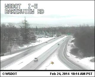
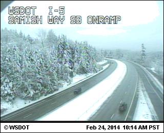
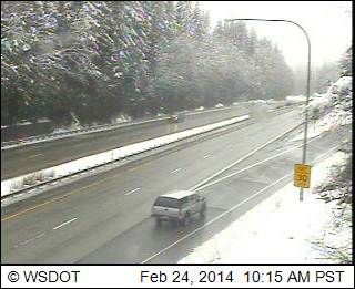
As of Monday morning, another 3-15" of new snow has fallen over the past 24 hours from about Whistler south to White Pass (bringing 2-day totals up to 1-2 ft at many sites), with only an inch or two farther south to Mount Hood and Bachelor followed by rain as the snow level rose to 7000 and even 8000 ft, and still sunny skies from southern Oregon into California. There is an amazing contrast and sharp north-south gradient in snow levels this morning, ranging from sea level near Bellingham, to 1000-2000 ft at Stevens and Snoqualmie Passes (assisted by easterly pass flow), to 6000 ft at Mount Rainier and 8000 ft on Mount Hood, due to a weird combo of cold Fraser River outflow, cold easterly pass flow, and warm air being pulled up from the southwest.
The largest new snowfalls were in parts of southwestern BC and the North Cascades with about 1 ft, topped by 15" at Whistler (surprisingly, its largest 24-hour snowfall of the entire storm cycle), 13" at Holden Village (on top of 14" yesterday, bringing its storm total snowfall up to 128", astounding given that it's several miles east of the Cascade Crest), and 10" at Mount Baker Ski Area and Stevens Pass. Large parts of the lowlands of northwest Washington and the San Juan Islands also got up to 6-12" of new snow, as cold air flowing out of the Fraser River valley kept temperatures cool enough for snow. This area of maximum snowfall was once again farther north than the model had predicted, as it had shown 1 ft amounts in the Central Cascades with only a few inches on Mount Baker or southwestern BC, and the large amounts in the lowlands exceeded model predictions too.
Here are the same 3 webcams shown the past 2 days in Updates #14 and #15 above, along I-5 from MP 258 to 246 near Bellingham, still showing snowfall but getting close to changing to rain (elevations of these webcams are about 200 ft, 200 ft, and 560 ft at I-5 at Lake Samish Park and Ride in the last image):
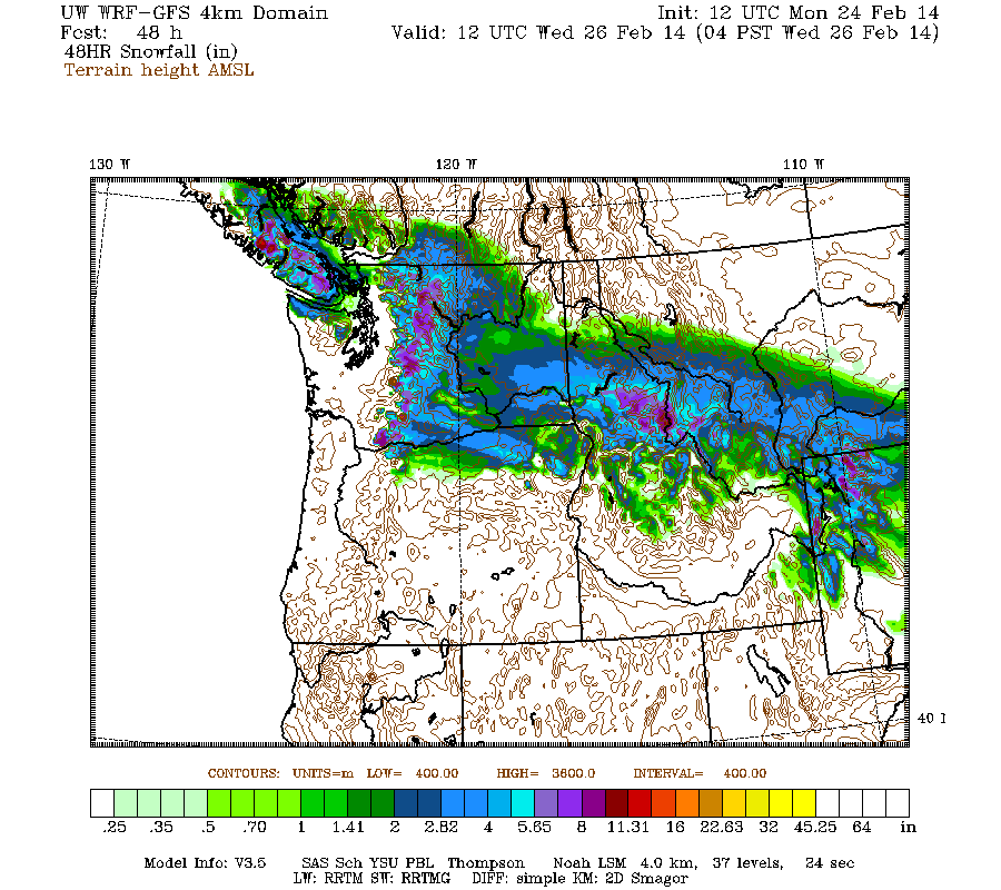
Snowfall in the Washington Cascades is again expected to intensify midday Monday through the afternoon, and continue into early Tuesday. Snowfall during the next 2 days through 4am Wednesday (which catches all the last bits of this storm cycle) is predicted to be up to 0.5-1 ft over most of the Washington Cascades north of Mount Rainier and central Vancouver Island, with several inches over parts of the mainland of southwestern BC, the Olympics, southern Washington Cascades, and Columbia Gorge:
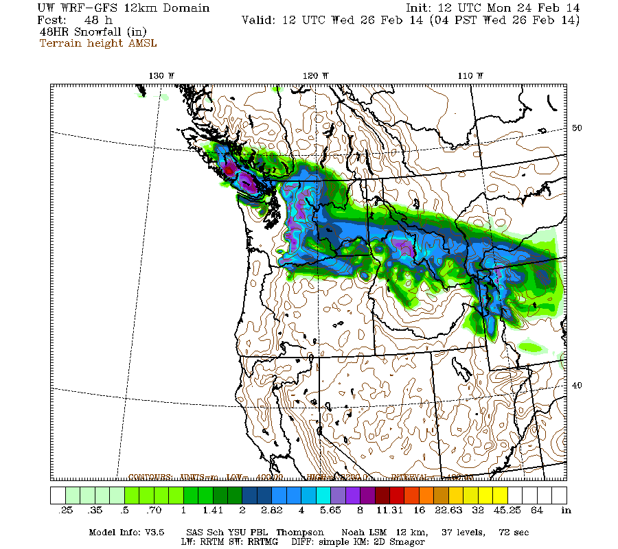
Higher resolution version of that, showing the Pacific Northwest and also zoomed in on Washington:
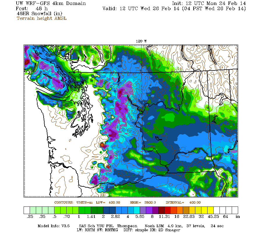
Maximum snowfall amounts of over 1 ft are still shown on Mount Rainier, but this is looking increasingly doubtful at least at any measurement sites like Paradise since snow levels have risen to 6000 ft. Almost no more snow is expected in the Oregon Cascades due to very high snow levels, except along the Columbia Gorge where easterly flow will keep temps cold enough for snow.
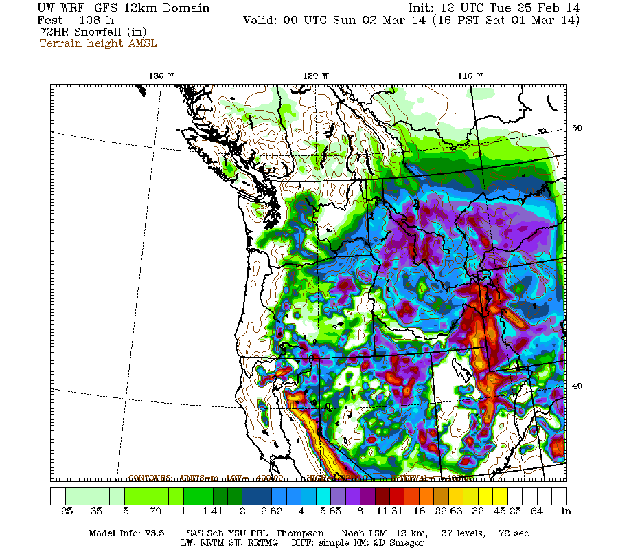
The next storm cycle is still predicted to begin on Wednesday, although the timing has continued to look slightly later than it did a few days ago, with the first system arriving from the southwest into northern California and southern Oregon midday Wednesday through Thursday, with another system on Friday into Saturday and Sunday. Snowfall from that new storm cycle during the 3-day period ending 4pm next Saturday is still predicted to be up to 2-3 ft at higher elevations of the California Cascades, Trinity Alps, and Sierra Nevada, similar to 24 hours ago with perhaps a slight increase:
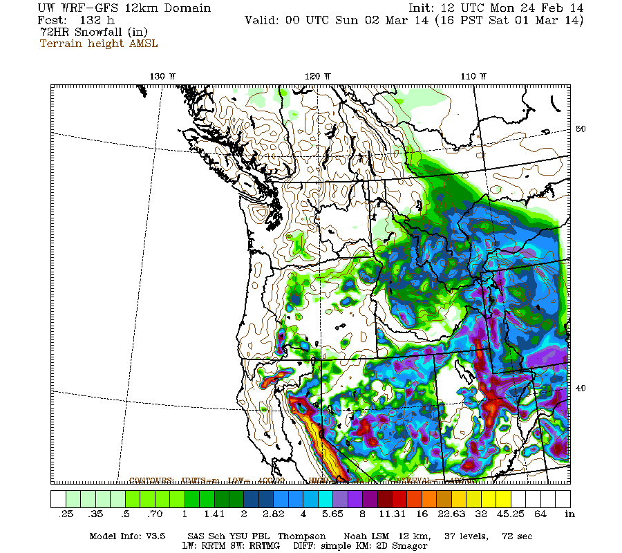
It still appears likely that this critically-needed major storm cycle for California will actually occur, but details and timing continue to change substantially on subsequent model runs, as do the total snowfall amounts as seen in the D(model)/D(t) for this period, including 5 runs over the last 3 days:
www.atmos.washington.edu/~ovens/wxloop.c...2+v2014030200///+-st
Now on to analyzing, calculating, and adding up the snowfall totals for the entire storm cycle at over 200 measurement sites from Alaska to the southern Sierra Nevada . . .
perhaps up to 14-15 ft or more in spots, with an additional 0.5-1 ft predicted through Tuesday!
Another brief update on the last day of significant snowfall during this storm cycle, as 2 more subsequent runs of the UW WRF-GFS model at 12-hour intervals continue to predict up to an additional 0.5-1 ft of snowfall over the Washington Cascades through Tuesday morning. The lowland snowfall in northwestern Washington over the past 2 days is expected to change over to all rain soon.
As of Monday morning, another 3-15" of new snow has fallen over the past 24 hours from about Whistler south to White Pass (bringing 2-day totals up to 1-2 ft at many sites), with only an inch or two farther south to Mount Hood and Bachelor followed by rain as the snow level rose to 7000 and even 8000 ft, and still sunny skies from southern Oregon into California. There is an amazing contrast and sharp north-south gradient in snow levels this morning, ranging from sea level near Bellingham, to 1000-2000 ft at Stevens and Snoqualmie Passes (assisted by easterly pass flow), to 6000 ft at Mount Rainier and 8000 ft on Mount Hood, due to a weird combo of cold Fraser River outflow, cold easterly pass flow, and warm air being pulled up from the southwest.
The largest new snowfalls were in parts of southwestern BC and the North Cascades with about 1 ft, topped by 15" at Whistler (surprisingly, its largest 24-hour snowfall of the entire storm cycle), 13" at Holden Village (on top of 14" yesterday, bringing its storm total snowfall up to 128", astounding given that it's several miles east of the Cascade Crest), and 10" at Mount Baker Ski Area and Stevens Pass. Large parts of the lowlands of northwest Washington and the San Juan Islands also got up to 6-12" of new snow, as cold air flowing out of the Fraser River valley kept temperatures cool enough for snow. This area of maximum snowfall was once again farther north than the model had predicted, as it had shown 1 ft amounts in the Central Cascades with only a few inches on Mount Baker or southwestern BC, and the large amounts in the lowlands exceeded model predictions too.
Here are the same 3 webcams shown the past 2 days in Updates #14 and #15 above, along I-5 from MP 258 to 246 near Bellingham, still showing snowfall but getting close to changing to rain (elevations of these webcams are about 200 ft, 200 ft, and 560 ft at I-5 at Lake Samish Park and Ride in the last image):
Snowfall in the Washington Cascades is again expected to intensify midday Monday through the afternoon, and continue into early Tuesday. Snowfall during the next 2 days through 4am Wednesday (which catches all the last bits of this storm cycle) is predicted to be up to 0.5-1 ft over most of the Washington Cascades north of Mount Rainier and central Vancouver Island, with several inches over parts of the mainland of southwestern BC, the Olympics, southern Washington Cascades, and Columbia Gorge:
Higher resolution version of that, showing the Pacific Northwest and also zoomed in on Washington:
Maximum snowfall amounts of over 1 ft are still shown on Mount Rainier, but this is looking increasingly doubtful at least at any measurement sites like Paradise since snow levels have risen to 6000 ft. Almost no more snow is expected in the Oregon Cascades due to very high snow levels, except along the Columbia Gorge where easterly flow will keep temps cold enough for snow.
The next storm cycle is still predicted to begin on Wednesday, although the timing has continued to look slightly later than it did a few days ago, with the first system arriving from the southwest into northern California and southern Oregon midday Wednesday through Thursday, with another system on Friday into Saturday and Sunday. Snowfall from that new storm cycle during the 3-day period ending 4pm next Saturday is still predicted to be up to 2-3 ft at higher elevations of the California Cascades, Trinity Alps, and Sierra Nevada, similar to 24 hours ago with perhaps a slight increase:
It still appears likely that this critically-needed major storm cycle for California will actually occur, but details and timing continue to change substantially on subsequent model runs, as do the total snowfall amounts as seen in the D(model)/D(t) for this period, including 5 runs over the last 3 days:
www.atmos.washington.edu/~ovens/wxloop.c...2+v2014030200///+-st
Now on to analyzing, calculating, and adding up the snowfall totals for the entire storm cycle at over 200 measurement sites from Alaska to the southern Sierra Nevada . . .
Please Log in or Create an account to join the conversation.
- Amar Andalkar
-
Topic Author
- User
-
Less
More
- Posts: 635
- Thank you received: 0
12 years 1 month ago - 12 years 1 month ago #220807
by Amar Andalkar
Replied by Amar Andalkar on topic Re: HUGE storm cycle brings 4-14 ft snow Feb6-25,2014!
Sunrise after the storm (again!):
Well, it's finally over. The storm cycle that kept going and going and going, is coming to an end at long last on Tuesday with the last remnants of the final storm system fading out along the Washington-Oregon border. As of Tuesday morning, another 2-7" of new snow has fallen over the past 24 hours from about Whistler south to White Pass, along with rain at many locations away from the passes without the benefit of easterly flow to keep temperatures down. There was rain up to 5000-6000 ft at Mount Baker, Hurricane Ridge, Crystal Mountain, Mount Rainier Paradise, etc., plus some freezing rain near the passes too. This is the Pacific Northwest after all!
Skies again cleared by sunrise at many mountain locations north and south of the Washington-Oregon border region in southwestern BC, northern Washington, and southern Oregon (and remained clear in California):
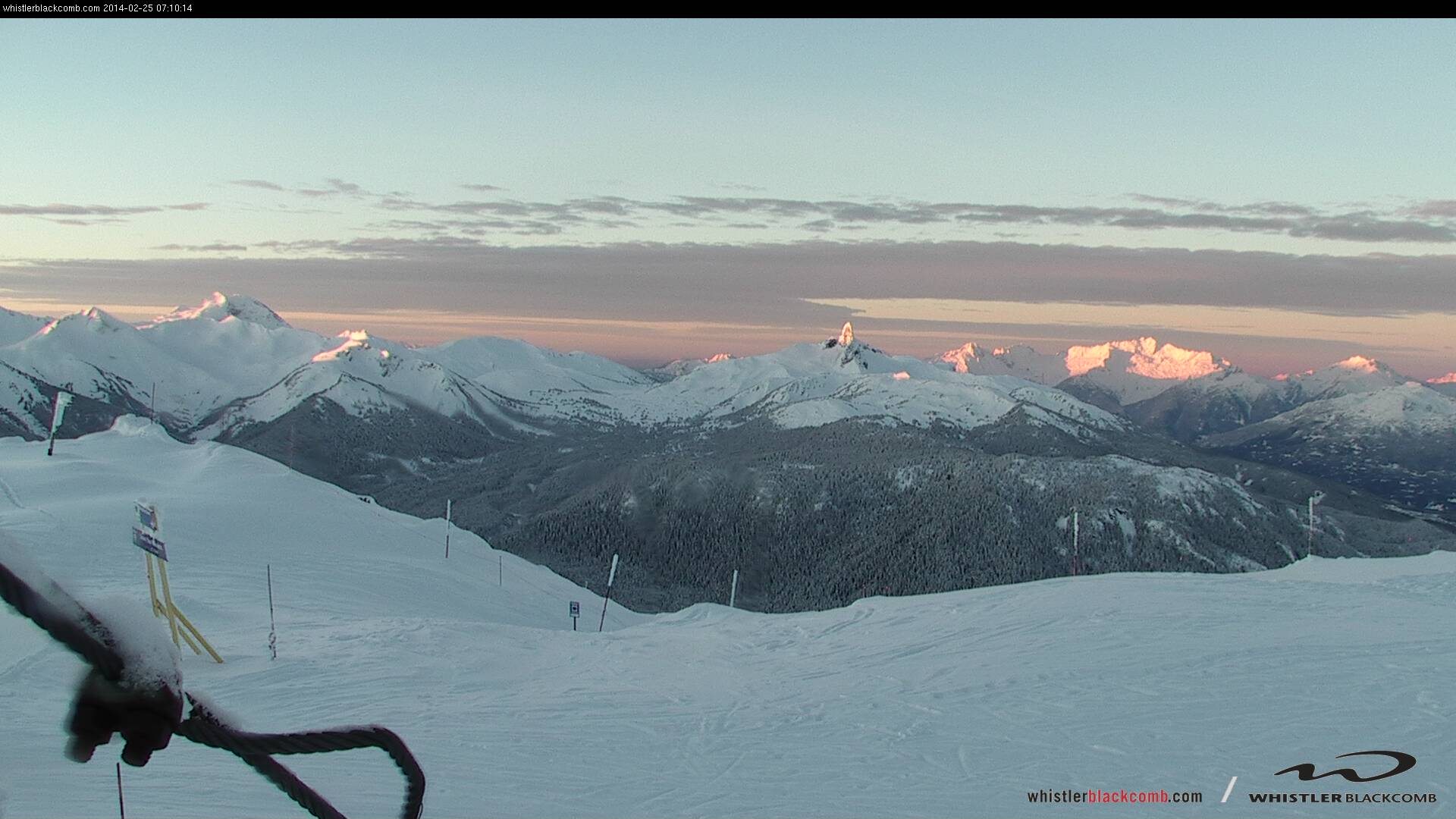
[size=small]Sunrise from atop Whistler Mountain on the volcanic peaks of Mount Garibaldi (left) and Black Tusk (center) plus Mount Tantalus (right).[/size]
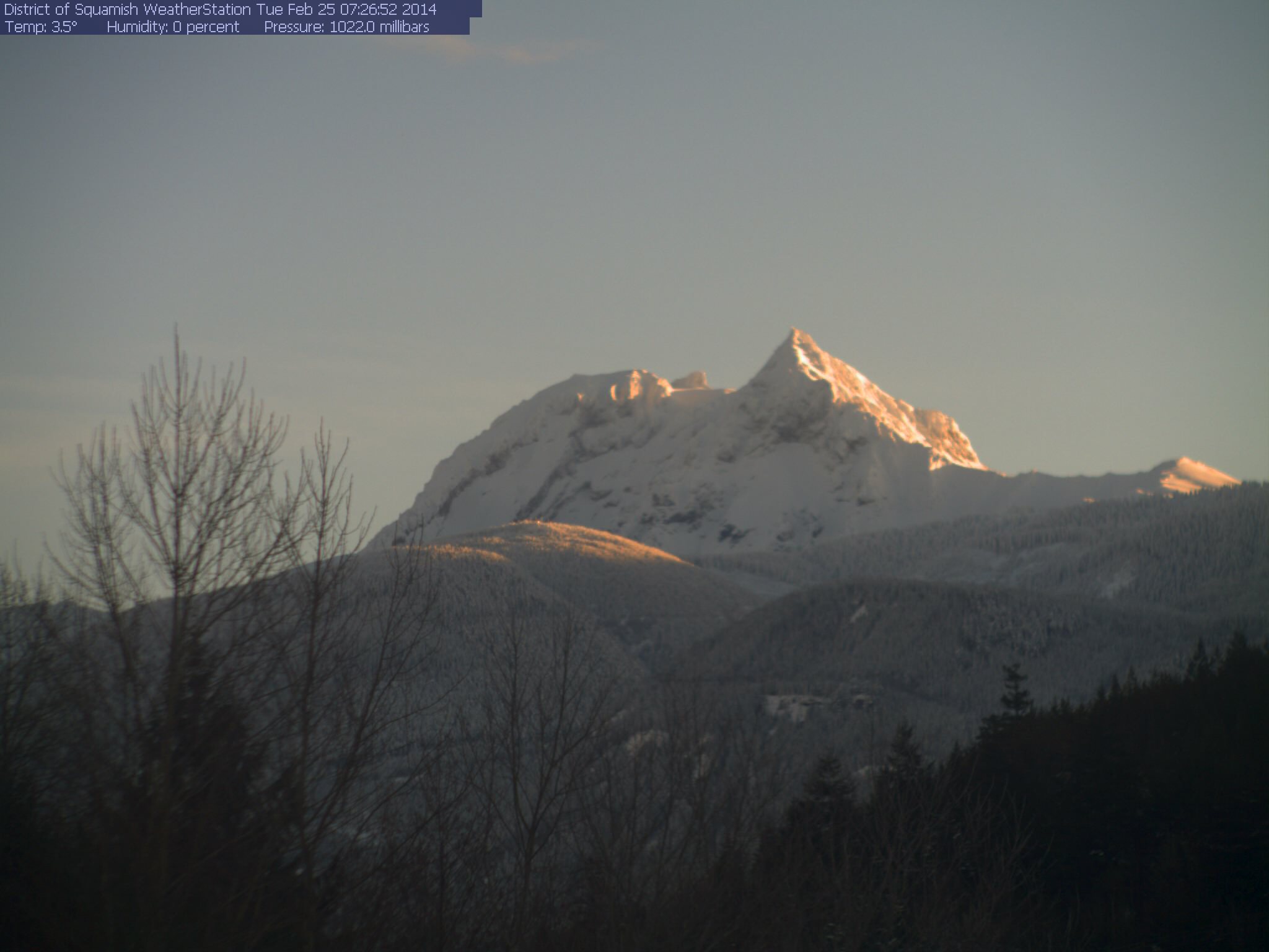
[size=small]Sunrise on Mount Garibaldi seen from the opposite direction near Squamish .[/size]
[size=small]Sunrise glow behind Mount Baker and Twin Sisters Mountain, as seen on the visibility camera from Ferndale at 350 ft with snow on the rooftops.[/size]
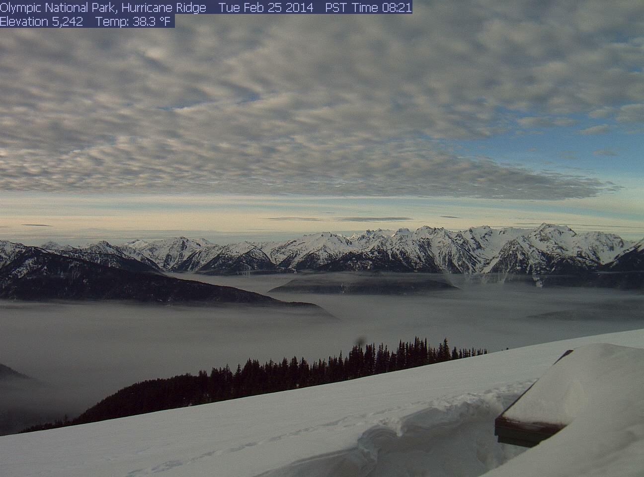
[size=small]Cool clouds above and below in the valley from Hurricane Ridge .[/size]
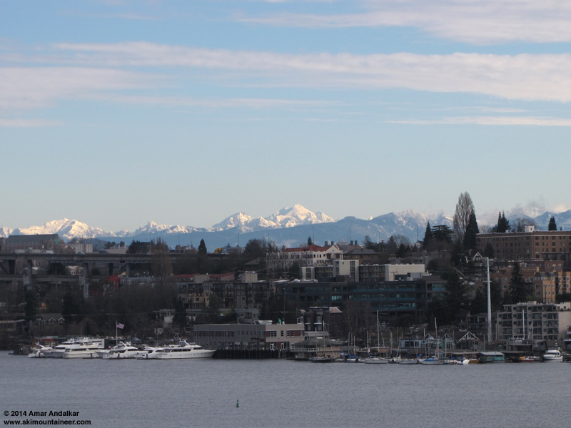
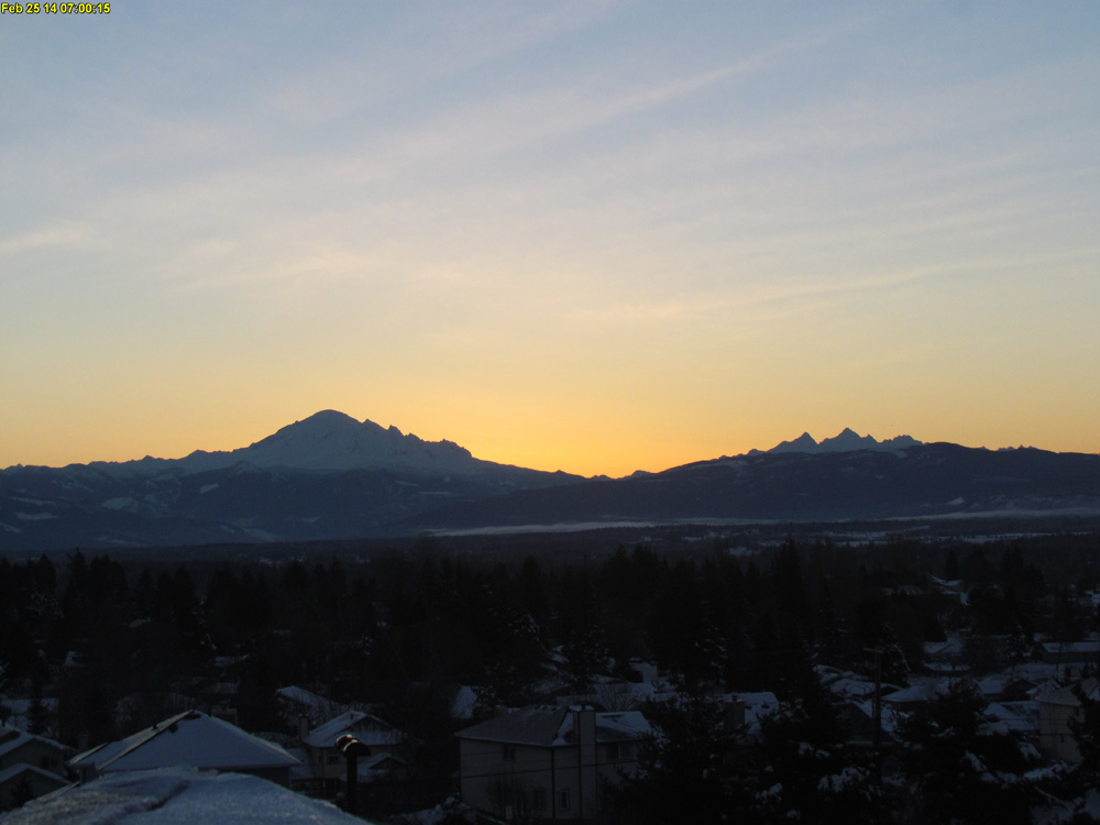
[size=small]Clear skies on Glacier Peak, as seen from my deck in Seattle, 10:00am February 25.[/size]
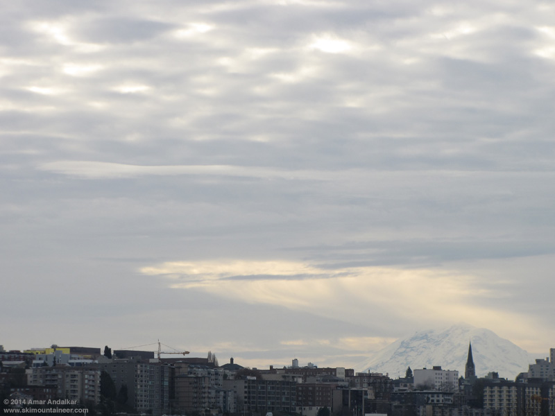
[size=small]Mount Rainier producing a fallstreak hole in an altocumulus cloud deck advancing from the southwest, as seen from my deck in Seattle, 9:00am February 25.[/size]
This is the second time I can recall seeing Mount Rainier produce a fallstreak hole in an altocumulus cloud deck, see this thread from 2 years ago ( Unusual lenticular "hole" cloud above Mt Rainier ). This time it is a very obvious and classic-looking fallstreak hole , complete with the typical wispy cloud debris streaming downward from the hole. Here is a wider-angle view taken 15 minutes later, showing the hole having moved farther to the NE of Rainier:
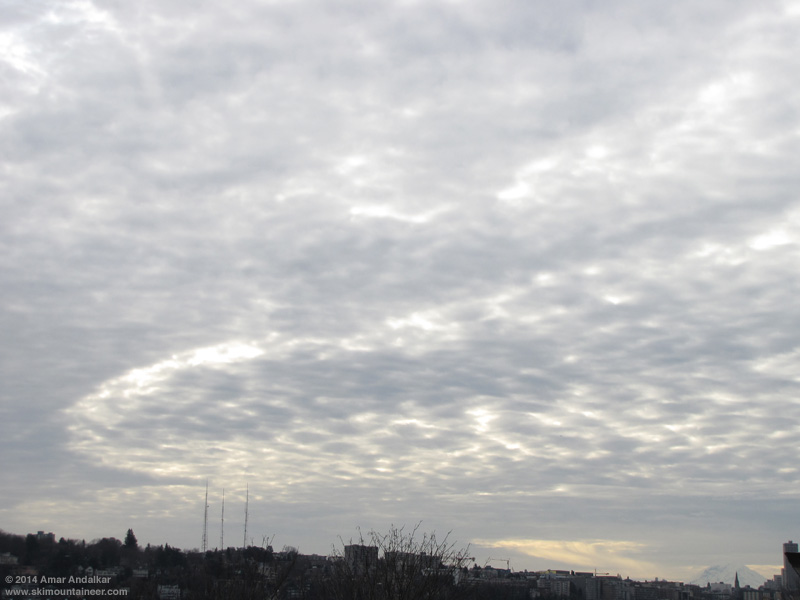
[size=small]Mount Rainier producing a fallstreak hole in an altocumulus cloud deck advancing from the southwest, as seen from my deck in Seattle, 9:15am February 25.[/size]
One of the UW Atmospheric Sciences webcams has a view of Rainier, and this loop of images every 5 minutes from 8-10am on February 25 shows the formation and motion of the fallstreak hole from 8:45am over the next hour (ignore the times listed at top which are 8 hours off, the correct times are printed on the images). You can also view the same loop with a 1 minute interval, loop of images every minute from 8-10am on February 25 .
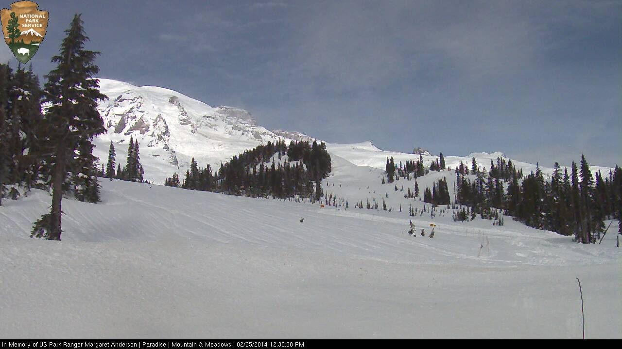
[size=small]The Mountain was only out for a short time early in the morning and again just after noon from the other side at Paradise .[/size]
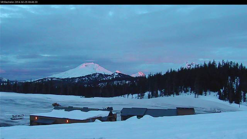
[size=small]Sunrise glow just reaching the summits of South Sister, Middle Sister, and North Sister (left to right) as seen from Mount Bachelor .[/size]
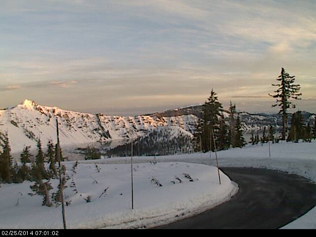
[size=small]Sunrise at Crater Lake .[/size]
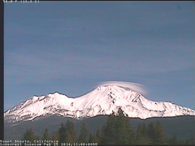
[size=small]Mount Shasta briefly capped by a short stack of thin lenticular clouds on Tuesday morning, as seen on the SnowCrest webcam .[/size]
[hr]Update on the next storm cycle:
Still on track and now nearly certain to occur! The next storm cycle is still predicted to begin on Wednesday, with the first system arriving from the southwest into northern California and southern Oregon midday Wednesday through Thursday, with another system on Friday into Saturday. Snowfall from that new storm cycle during the 3-day period ending 4pm Saturday is still predicted to be up to 2-3 ft at higher elevations of the California Cascades, Trinity Alps, and Sierra Nevada, similar to 24 hours ago with perhaps a slight increase in amounts and also with some snowfall extending farther north into Washington:
This loop shows how the model predictions for snowfall during the 3-day period through 4pm Saturday have evolved between 7 subsequent runs over the last 4 days, the D(model)/D(t). Fairly consistent in the overall picture for California throughout these runs, although with variations in details and timing and total snowfall amounts:
www.atmos.washington.edu/~ovens/wxloop.c...2+v2014030200///+-st
There is a major lull on Sunday, then the next system is predicted for Monday-Tuesday into Oregon and southern Washington. This is the (shocking!) prediction for snowfall during the 24-hour period ending 4pm next Tuesday:
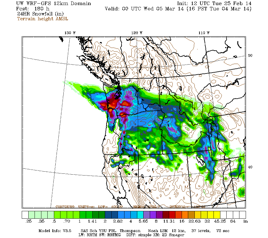
Yes, it's showing a large area of lowland snowfall throughout southwestern Washington and northwestern Oregon, with amounts exceeding 1 ft over a good portion of that. This certainly bears watching, but is a highly improbable prediction given climatology and is still 6-7 days out, right at the limit of accurate numerical weather prediction. More than likely, this lowland snowfall will vanish or be greatly reduced in later model runs. We shall see!
Well, it's finally over. The storm cycle that kept going and going and going, is coming to an end at long last on Tuesday with the last remnants of the final storm system fading out along the Washington-Oregon border. As of Tuesday morning, another 2-7" of new snow has fallen over the past 24 hours from about Whistler south to White Pass, along with rain at many locations away from the passes without the benefit of easterly flow to keep temperatures down. There was rain up to 5000-6000 ft at Mount Baker, Hurricane Ridge, Crystal Mountain, Mount Rainier Paradise, etc., plus some freezing rain near the passes too. This is the Pacific Northwest after all!
Skies again cleared by sunrise at many mountain locations north and south of the Washington-Oregon border region in southwestern BC, northern Washington, and southern Oregon (and remained clear in California):
[size=small]Sunrise from atop Whistler Mountain on the volcanic peaks of Mount Garibaldi (left) and Black Tusk (center) plus Mount Tantalus (right).[/size]
[size=small]Sunrise on Mount Garibaldi seen from the opposite direction near Squamish .[/size]
[size=small]Sunrise glow behind Mount Baker and Twin Sisters Mountain, as seen on the visibility camera from Ferndale at 350 ft with snow on the rooftops.[/size]
[size=small]Cool clouds above and below in the valley from Hurricane Ridge .[/size]
[size=small]Clear skies on Glacier Peak, as seen from my deck in Seattle, 10:00am February 25.[/size]
[size=small]Mount Rainier producing a fallstreak hole in an altocumulus cloud deck advancing from the southwest, as seen from my deck in Seattle, 9:00am February 25.[/size]
This is the second time I can recall seeing Mount Rainier produce a fallstreak hole in an altocumulus cloud deck, see this thread from 2 years ago ( Unusual lenticular "hole" cloud above Mt Rainier ). This time it is a very obvious and classic-looking fallstreak hole , complete with the typical wispy cloud debris streaming downward from the hole. Here is a wider-angle view taken 15 minutes later, showing the hole having moved farther to the NE of Rainier:
[size=small]Mount Rainier producing a fallstreak hole in an altocumulus cloud deck advancing from the southwest, as seen from my deck in Seattle, 9:15am February 25.[/size]
One of the UW Atmospheric Sciences webcams has a view of Rainier, and this loop of images every 5 minutes from 8-10am on February 25 shows the formation and motion of the fallstreak hole from 8:45am over the next hour (ignore the times listed at top which are 8 hours off, the correct times are printed on the images). You can also view the same loop with a 1 minute interval, loop of images every minute from 8-10am on February 25 .
[size=small]The Mountain was only out for a short time early in the morning and again just after noon from the other side at Paradise .[/size]
[size=small]Sunrise glow just reaching the summits of South Sister, Middle Sister, and North Sister (left to right) as seen from Mount Bachelor .[/size]
[size=small]Sunrise at Crater Lake .[/size]
[size=small]Mount Shasta briefly capped by a short stack of thin lenticular clouds on Tuesday morning, as seen on the SnowCrest webcam .[/size]
[hr]Update on the next storm cycle:
Still on track and now nearly certain to occur! The next storm cycle is still predicted to begin on Wednesday, with the first system arriving from the southwest into northern California and southern Oregon midday Wednesday through Thursday, with another system on Friday into Saturday. Snowfall from that new storm cycle during the 3-day period ending 4pm Saturday is still predicted to be up to 2-3 ft at higher elevations of the California Cascades, Trinity Alps, and Sierra Nevada, similar to 24 hours ago with perhaps a slight increase in amounts and also with some snowfall extending farther north into Washington:
This loop shows how the model predictions for snowfall during the 3-day period through 4pm Saturday have evolved between 7 subsequent runs over the last 4 days, the D(model)/D(t). Fairly consistent in the overall picture for California throughout these runs, although with variations in details and timing and total snowfall amounts:
www.atmos.washington.edu/~ovens/wxloop.c...2+v2014030200///+-st
There is a major lull on Sunday, then the next system is predicted for Monday-Tuesday into Oregon and southern Washington. This is the (shocking!) prediction for snowfall during the 24-hour period ending 4pm next Tuesday:
Yes, it's showing a large area of lowland snowfall throughout southwestern Washington and northwestern Oregon, with amounts exceeding 1 ft over a good portion of that. This certainly bears watching, but is a highly improbable prediction given climatology and is still 6-7 days out, right at the limit of accurate numerical weather prediction. More than likely, this lowland snowfall will vanish or be greatly reduced in later model runs. We shall see!
Please Log in or Create an account to join the conversation.
- DendriteSupertramp
-
- User
-
Less
More
- Posts: 25
- Thank you received: 0
12 years 1 month ago #220812
by DendriteSupertramp
Replied by DendriteSupertramp on topic Re: HUGE storm cycle brings 4-14 ft snow Feb6-25,2014!
Isn't the EURO better in the long range? Doesn't show nearly the precip.
Please Log in or Create an account to join the conversation.
- Amar Andalkar
-
Topic Author
- User
-
Less
More
- Posts: 635
- Thank you received: 0
12 years 1 month ago #220814
by Amar Andalkar
Well, if you're referring to the European model (ECMWF), it never shows me any precip at all. Because I have no way of accessing any of its precip predictions, since they are not freely available to the public.
I can view the very limited freely-available ECMWF pressures / heights predictions on various websites, and even the 3-hour ECMWF snowfall layer on Wundermap (not very useful with no way to sum over 24 hours), but that's all I know of.
If you know where to find ECMWF model precip and snowfall predictions for free online, please let me know, thanks.
Replied by Amar Andalkar on topic Re: HUGE storm cycle brings 4-14 ft snow Feb6-25,2014!
Isn't the EURO better in the long range? Doesn't show nearly the precip.
Well, if you're referring to the European model (ECMWF), it never shows me any precip at all. Because I have no way of accessing any of its precip predictions, since they are not freely available to the public.
I can view the very limited freely-available ECMWF pressures / heights predictions on various websites, and even the 3-hour ECMWF snowfall layer on Wundermap (not very useful with no way to sum over 24 hours), but that's all I know of.
If you know where to find ECMWF model precip and snowfall predictions for free online, please let me know, thanks.
Please Log in or Create an account to join the conversation.
- andybrnr
-
- User
-
Less
More
- Posts: 25
- Thank you received: 0
12 years 1 month ago #220816
by andybrnr
Replied by andybrnr on topic Re: HUGE storm cycle brings 4-14 ft snow Feb6-25,2014!
Even in the UW Atmos Sci Dept., we don't have access to the ECMWF output, and if we did, the terms under which we got it would prevent it from being shared. Again, at 7 days out, I'd really suggest relying on ensemble output as opposed to a single deterministic run... as Amar suggests, at 7 days climatology is about as skillful a predictor (depending on the exact model, climatology may be a MORE skillful predictor).
So, back to my personal favorite tool for prognostications beyond 5 days, NAEFS. It combines the outputs from the Canadian and American ensemble systems, for a total of 42 different possible realizations of the atmosphere out to two weeks. For point forecasts at individual cities, this data is statistically corrected to produce calibrated, unbiased probability distributions for a number of variables. To appreciate the general pattern, viewing contour maps of the model mean and standard deviation can provide some information, but at two weeks this looks pretty messy... you can also look at all the individual ensemble members, but that gets overwhelming. Thus I think using the Seattle forecast as a proxy for the downstream conditions in the Central Cascades is a good first approach... it gives a sense of the range of possible outcomes, the degree of uncertainty, and as a given time gets closer, the higher resolution deterministic runs become somewhat more useful.
So, let's look at the two most recent NAEFS EPSgrams for Seattle:
2-25-14 00Z

2-25-14 12Z

Be careful when comparing the vertical scales between runs, as they adapt to max values. There are some substantial differences between these runs even in the near term; the chances of precip before the weekend have come up a bit. Both runs show we're likely to get some cold air down towards the beginning of next week, and it may in fact include a chance for lowland snow... but the range of possible outcomes is quite big, and the bars for the 25-75% are substantial. Anyhow, it is clear there is substantial uncertainty in the next week, with a few days of colder conditions followed by a trend to warmer conditions in the longer term (8-14 days).
So, back to my personal favorite tool for prognostications beyond 5 days, NAEFS. It combines the outputs from the Canadian and American ensemble systems, for a total of 42 different possible realizations of the atmosphere out to two weeks. For point forecasts at individual cities, this data is statistically corrected to produce calibrated, unbiased probability distributions for a number of variables. To appreciate the general pattern, viewing contour maps of the model mean and standard deviation can provide some information, but at two weeks this looks pretty messy... you can also look at all the individual ensemble members, but that gets overwhelming. Thus I think using the Seattle forecast as a proxy for the downstream conditions in the Central Cascades is a good first approach... it gives a sense of the range of possible outcomes, the degree of uncertainty, and as a given time gets closer, the higher resolution deterministic runs become somewhat more useful.
So, let's look at the two most recent NAEFS EPSgrams for Seattle:
2-25-14 00Z
2-25-14 12Z
Be careful when comparing the vertical scales between runs, as they adapt to max values. There are some substantial differences between these runs even in the near term; the chances of precip before the weekend have come up a bit. Both runs show we're likely to get some cold air down towards the beginning of next week, and it may in fact include a chance for lowland snow... but the range of possible outcomes is quite big, and the bars for the 25-75% are substantial. Anyhow, it is clear there is substantial uncertainty in the next week, with a few days of colder conditions followed by a trend to warmer conditions in the longer term (8-14 days).
Please Log in or Create an account to join the conversation.
- DendriteSupertramp
-
- User
-
Less
More
- Posts: 25
- Thank you received: 0
12 years 1 month ago #220842
by DendriteSupertramp
Admittedly I am a hack.....I glean all info from NOAA with a healthy assessment of Opensnow.com (Tahoe discussion)
1. Opensnow
2. NOAA
3. NWAC
Larry Schick is on opensnow now....although his candy-coated discussion is never correct (his snow levels always seem to be different than NWAC)
Ed
Replied by DendriteSupertramp on topic Re: HUGE storm cycle brings 4-14 ft snow Feb6-25,2014!
Well, if you're referring to the European model (ECMWF), it never shows me any precip at all. Because I have no way of accessing any of its precip predictions, since they are not freely available to the public.
I can view the very limited freely-available ECMWF pressures / heights predictions on various websites, and even the 3-hour ECMWF snowfall layer on
If you know where to find ECMWF model precip and snowfall predictions for free online, please let me know, thanks.
Admittedly I am a hack.....I glean all info from NOAA with a healthy assessment of Opensnow.com (Tahoe discussion)
1. Opensnow
2. NOAA
3. NWAC
Larry Schick is on opensnow now....although his candy-coated discussion is never correct (his snow levels always seem to be different than NWAC)
Ed
Please Log in or Create an account to join the conversation.