- Posts: 28
- Thank you received: 0
Major storm cycle brings 4-8 ft of snow Jan 7-14!
- freg
-

- User
-

Less
More
12 years 5 months ago #211607
by freg
Replied by freg on topic Re: Major storm cycle brings 4-8 ft of snow this week?
It will undoubtedly snow 2-3 feet Friday night/ Saturday morning as I plan on watching the Seahawks game Saturday and not heading up until Sunday. You guys are welcome.
Please Log in or Create an account to join the conversation.
- Amar Andalkar
-
Topic Author
- User
-
Less
More
- Posts: 635
- Thank you received: 0
12 years 5 months ago #211609
by Amar Andalkar
Replied by Amar Andalkar on topic Re: Major storm cycle brings 4-8 ft of snow this week?
Update: 24 hours later, models are still predicting 4-8 ft (or more) of snow this week
A day later, and 2 subsequent runs of the UW WRF-GFS model at 12-hour intervals continue to show similar predictions for large snowfall amounts. Consistency between subsequent model runs typically tends to indicate that the predictions are more likely to actually verify.
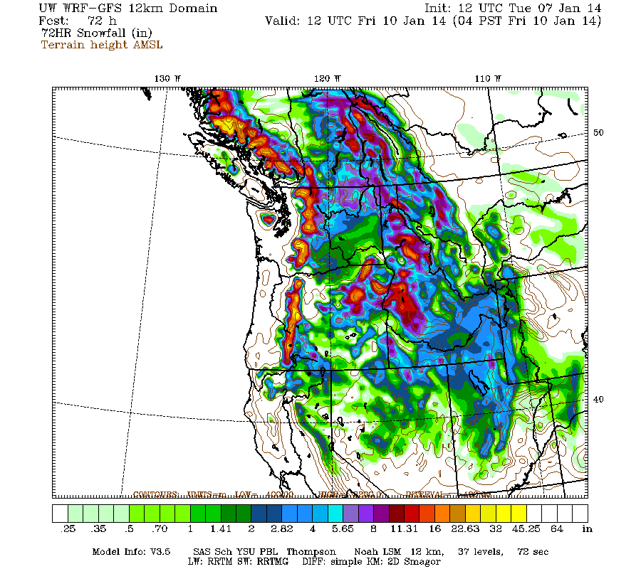
Snowfall during the next 3 days through 4am Friday is still predicted to be 2-4 ft over the west slopes and volcanic peaks of the Washington and Oregon Cascades, plus the Olympics:
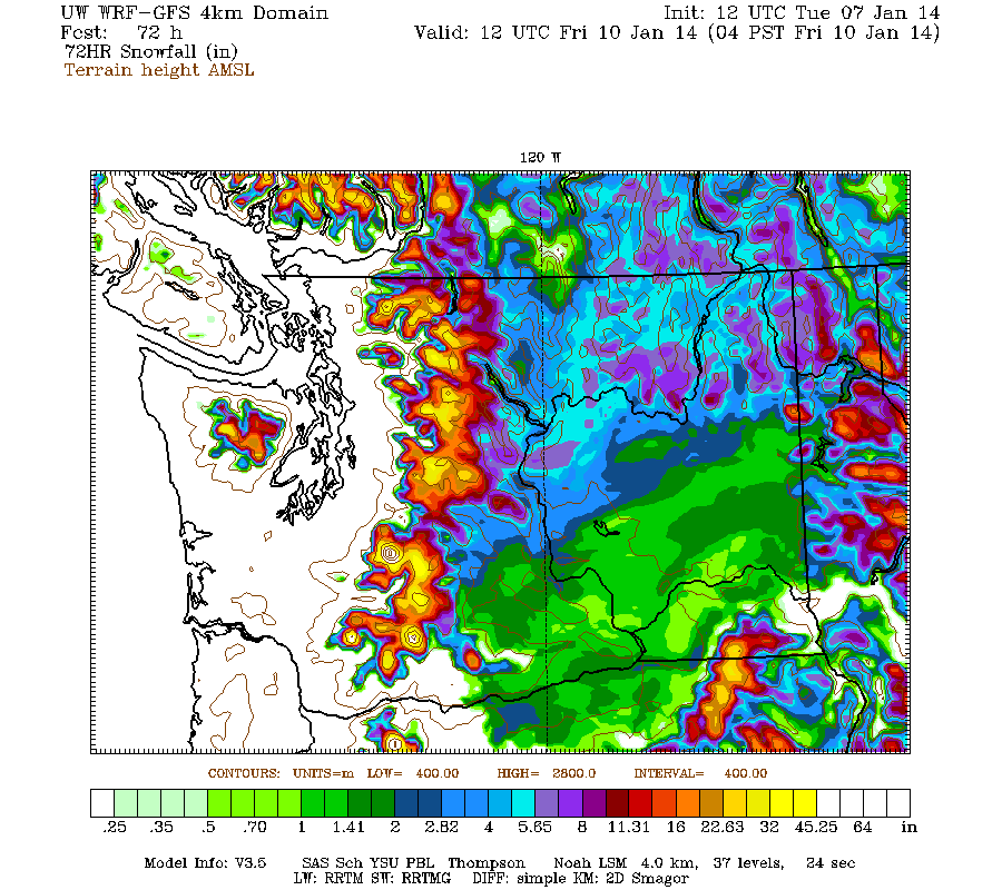
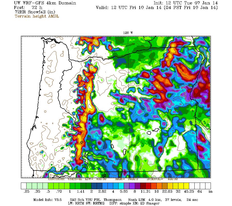
Higher resolution version of that, zoomed in on WA and OR:
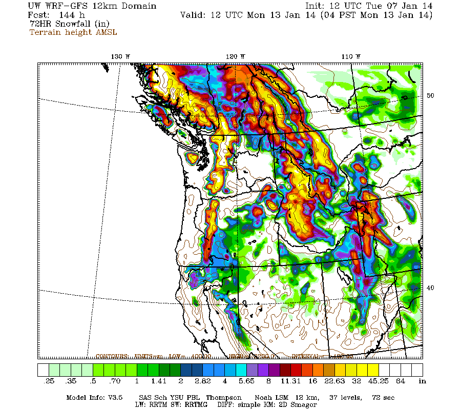
There's still a one-day lull predicted around Thursday evening into early Friday, then another sustained period of snowfall through Sunday. This second part of the storm cycle now looks to be much stronger and wetter, with much more snowfall predicted over the weekend and extending much farther south into Oregon too. The model now shows another 2-6 ft of snowfall over the Washington Cascades by Monday, with 2-3 ft for the Olympics and Oregon:
A day later, and 2 subsequent runs of the UW WRF-GFS model at 12-hour intervals continue to show similar predictions for large snowfall amounts. Consistency between subsequent model runs typically tends to indicate that the predictions are more likely to actually verify.
Snowfall during the next 3 days through 4am Friday is still predicted to be 2-4 ft over the west slopes and volcanic peaks of the Washington and Oregon Cascades, plus the Olympics:
Higher resolution version of that, zoomed in on WA and OR:
There's still a one-day lull predicted around Thursday evening into early Friday, then another sustained period of snowfall through Sunday. This second part of the storm cycle now looks to be much stronger and wetter, with much more snowfall predicted over the weekend and extending much farther south into Oregon too. The model now shows another 2-6 ft of snowfall over the Washington Cascades by Monday, with 2-3 ft for the Olympics and Oregon:
Please Log in or Create an account to join the conversation.
- JPH
-
- User
-
Less
More
- Posts: 165
- Thank you received: 1
12 years 5 months ago #211610
by JPH
Replied by JPH on topic Re: Major storm cycle brings 4-8 ft of snow this week?
Thanks for the info! NOAA says rain/snow on Friday night at Snoqualmie Pass (~5k').
Does the UW model agree, or does it predict that temps will stay low until Saturday?
Does the UW model agree, or does it predict that temps will stay low until Saturday?
Please Log in or Create an account to join the conversation.
- Charlie Hagedorn
-
- User
-
Less
More
- Posts: 913
- Thank you received: 1
12 years 5 months ago #211611
by Charlie Hagedorn
You can see for yourself with the 12km 5000' elevation temperatures:
Here's the GFS ("more precise"):
www.atmos.washington.edu/~ovens/wxloop.c..._wa_5000_snow+//84/3
Here's the NAM (more current, the GFS hasn't yet run since this morning)
www.atmos.washington.edu/~ovens/wxloop.c..._wa_5000_snow+//72/3
Both show freezing levels above 5k at Snoqualmie on Friday evening.
Replied by Charlie Hagedorn on topic Re: Major storm cycle brings 4-8 ft of snow this week?
Thanks for the info! NOAA says rain/snow on Friday night at Snoqualmie Pass (~5k').
Does the UW model agree, or does it predict that temps will stay low until Saturday?
You can see for yourself with the 12km 5000' elevation temperatures:
Here's the GFS ("more precise"):
www.atmos.washington.edu/~ovens/wxloop.c..._wa_5000_snow+//84/3
Here's the NAM (more current, the GFS hasn't yet run since this morning)
www.atmos.washington.edu/~ovens/wxloop.c..._wa_5000_snow+//72/3
Both show freezing levels above 5k at Snoqualmie on Friday evening.
Please Log in or Create an account to join the conversation.
- andybrnr
-
- User
-
Less
More
- Posts: 25
- Thank you received: 0
12 years 5 months ago #211615
by andybrnr
Replied by andybrnr on topic Re: Major storm cycle brings 4-8 ft of snow this week?
Saturday afternoon/night is when the temps really drop in the current runs and Snoqualmie will see some accumulation... but that's still a five day, I'll start trusting it more when the 4km run can see the event.
Andy
Andy
Please Log in or Create an account to join the conversation.
- Amar Andalkar
-
Topic Author
- User
-
Less
More
- Posts: 635
- Thank you received: 0
12 years 5 months ago - 12 years 5 months ago #211641
by Amar Andalkar
Replied by Amar Andalkar on topic Re: Major storm cycle brings 4-8 ft of snow this week?
Update #2: 48 hours after initial post, models are still predicting 4-8 ft (or more) of snow this week
Another day later, and 2 more subsequent runs of the UW WRF-GFS model at 12-hour intervals continue to show similar predictions for large snowfall amounts. There is definitely consistency between subsequent model runs through the weekend (still 5 days out at this point), which typically tends to indicate that the predictions are more likely to actually verify.
Up to 6" of new snow has already fallen as of Wednesday morning, with the largest amounts on Mounts Rainier, Hood, and Bachelor thus far. Additional snowfall during the next 2 days through 4am Friday is predicted to be 1-3 ft over the west slopes and volcanic peaks of the Washington and Oregon Cascades, plus the Olympics:
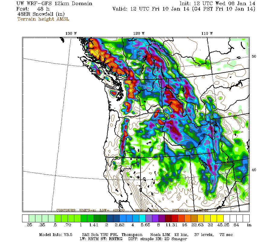
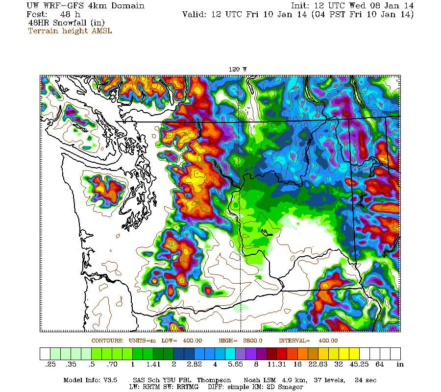
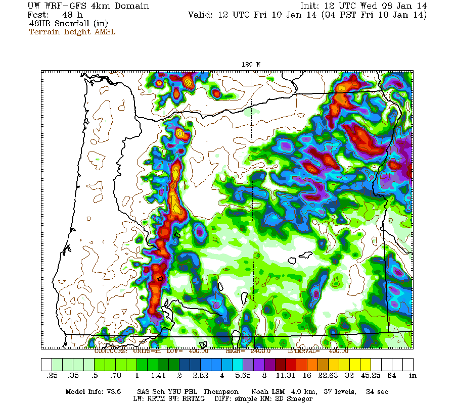
Higher resolution version of that, zoomed in on WA and OR:
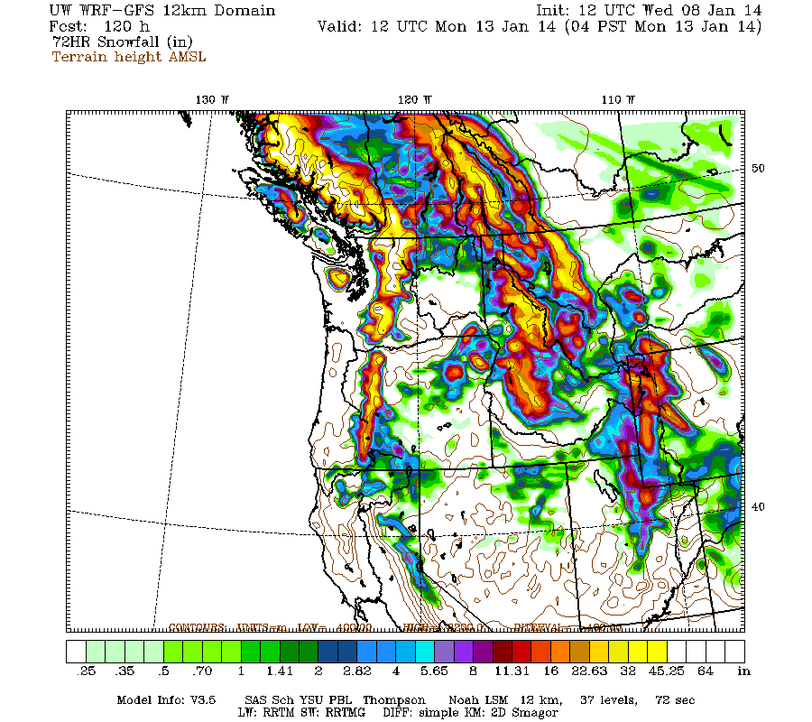
There's now a lull predicted around Thursday morning and again Friday morning with a brief period of precip in between, then another sustained period of snowfall from Friday afternoon through Sunday. This second part of the storm cycle continues to look much stronger and wetter than it did 2 days ago, with much more snowfall predicted over the weekend and extending much farther south into Oregon too. The model still shows another 2-6 ft of snowfall over the Washington Cascades during the 3-day period through 4am Monday, with 2-3 ft for the Olympics and Oregon:
This loop shows how the model predictions for snowfall during the 3-day period through 4am Friday have evolved between subsequent runs, known in the jargon as D(model)/D(t):
www.atmos.washington.edu/~ovens/wxloop.c...2+v2014011012///+-st
And similarly for the 3-day period through 4am Monday:
www.atmos.washington.edu/~ovens/wxloop.c...2+v2014011312///+-st
The model is showing some additional snowfall during Monday as this storm cycle fades out, but only about 4-8" in the WA Cascades with very little in the Olympics and Oregon.
And although this storm cycle now appears nearly-certain to boost snowdepths substantially in WA and OR, it will do little to help California, with only a few inches of new snow forecast to extend south as far as Lake Tahoe during the most intense part of the system on Saturday. The snowpack may be abnormally low in the Pacific Northwest now, but the situation in California is far more dire: there is almost no snow on the ground at all in the mountains, with less than 1 foot of snowpack throughout the California Cascades and Sierra Nevada, as many sites even at elevations above 7000 ft are reporting zero snow or only a few inches. Mount Shasta is almost completely bare of snow except the glaciers on the north and east sides, as is Lassen Peak on all sides (normally, Lassen is by far the snowiest location in California):
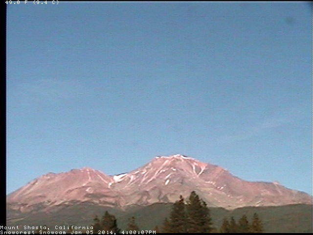
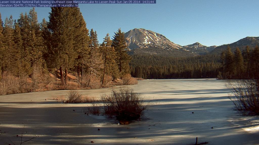
Just shocking images for early January! This is the third consecutive season where the California snowpack has been far below normal, and no relief appears to be on the horizon for that region in any forecast or outlook yet.
Another day later, and 2 more subsequent runs of the UW WRF-GFS model at 12-hour intervals continue to show similar predictions for large snowfall amounts. There is definitely consistency between subsequent model runs through the weekend (still 5 days out at this point), which typically tends to indicate that the predictions are more likely to actually verify.
Up to 6" of new snow has already fallen as of Wednesday morning, with the largest amounts on Mounts Rainier, Hood, and Bachelor thus far. Additional snowfall during the next 2 days through 4am Friday is predicted to be 1-3 ft over the west slopes and volcanic peaks of the Washington and Oregon Cascades, plus the Olympics:
Higher resolution version of that, zoomed in on WA and OR:
There's now a lull predicted around Thursday morning and again Friday morning with a brief period of precip in between, then another sustained period of snowfall from Friday afternoon through Sunday. This second part of the storm cycle continues to look much stronger and wetter than it did 2 days ago, with much more snowfall predicted over the weekend and extending much farther south into Oregon too. The model still shows another 2-6 ft of snowfall over the Washington Cascades during the 3-day period through 4am Monday, with 2-3 ft for the Olympics and Oregon:
This loop shows how the model predictions for snowfall during the 3-day period through 4am Friday have evolved between subsequent runs, known in the jargon as D(model)/D(t):
www.atmos.washington.edu/~ovens/wxloop.c...2+v2014011012///+-st
And similarly for the 3-day period through 4am Monday:
www.atmos.washington.edu/~ovens/wxloop.c...2+v2014011312///+-st
The model is showing some additional snowfall during Monday as this storm cycle fades out, but only about 4-8" in the WA Cascades with very little in the Olympics and Oregon.
And although this storm cycle now appears nearly-certain to boost snowdepths substantially in WA and OR, it will do little to help California, with only a few inches of new snow forecast to extend south as far as Lake Tahoe during the most intense part of the system on Saturday. The snowpack may be abnormally low in the Pacific Northwest now, but the situation in California is far more dire: there is almost no snow on the ground at all in the mountains, with less than 1 foot of snowpack throughout the California Cascades and Sierra Nevada, as many sites even at elevations above 7000 ft are reporting zero snow or only a few inches. Mount Shasta is almost completely bare of snow except the glaciers on the north and east sides, as is Lassen Peak on all sides (normally, Lassen is by far the snowiest location in California):
Just shocking images for early January! This is the third consecutive season where the California snowpack has been far below normal, and no relief appears to be on the horizon for that region in any forecast or outlook yet.
Please Log in or Create an account to join the conversation.