- Posts: 635
- Thank you received: 0
Major storm cycle brings 4-8 ft of snow Jan 7-14!
- Amar Andalkar
-
 Topic Author
- User
-

Less
More
12 years 5 months ago #211691
by Amar Andalkar
Apparently. Almost went to Crystal, but bailed at 6am after it barely got any snow overnight and I barely got any sleep. Even if I had skied, I probably would have posted the same update after I got home this evening. Maybe I should have gone, it looked nice and sunny up there for a couple hours before it socked in.
Replied by Amar Andalkar on topic Re: Major storm cycle brings 4-8 ft of snow this week?
Another slow day at the office?
Apparently. Almost went to Crystal, but bailed at 6am after it barely got any snow overnight and I barely got any sleep. Even if I had skied, I probably would have posted the same update after I got home this evening. Maybe I should have gone, it looked nice and sunny up there for a couple hours before it socked in.
Please Log in or Create an account to join the conversation.
- blackdog102395
-
- User
-
Less
More
- Posts: 161
- Thank you received: 1
12 years 5 months ago #219560
by blackdog102395
Replied by blackdog102395 on topic Re: Major storm cycle brings 4-8 ft of snow this week?
Super thankful for all the new snow. Unfortunately, I'm mired in real world responsibility this weekend. I'll have to live vicariously through the bevy of reports that are sure to appear. Unfortunately, the extended forecast looks a mess with high freezing levels and rain. Lots of snow and wind followed by a significant warm up and rain...hmm...stay safe out there this weekend and next week.
Please Log in or Create an account to join the conversation.
- Amar Andalkar
-
Topic Author
- User
-
Less
More
- Posts: 635
- Thank you received: 0
12 years 5 months ago #219564
by Amar Andalkar
I'm curious as to which extended forecast you looked at which showed that (high freezing levels and rain), and how far out in the future -- I'm not really seeing that in the models I've looked at, extending out 1 week (or even in the low-resolution extended GFS out to 16 days -- although model predictions beyond about 7 days have little forecast skill and are not reliable). This storm cycle is predicted to conclude with only a modest rise in snow levels at its tail end on Monday, followed by a period of mostly sunny warm weather during the upcoming week (Tues-Fri, especially south) as the persistent ridge rebuilds once again.
Replied by Amar Andalkar on topic Re: Major storm cycle brings 4-8 ft of snow this week?
Unfortunately, the extended forecast looks a mess with high freezing levels and rain. Lots of snow and wind followed by a significant warm up and rain...hmm...stay safe out there this weekend and next week.
I'm curious as to which extended forecast you looked at which showed that (high freezing levels and rain), and how far out in the future -- I'm not really seeing that in the models I've looked at, extending out 1 week (or even in the low-resolution extended GFS out to 16 days -- although model predictions beyond about 7 days have little forecast skill and are not reliable). This storm cycle is predicted to conclude with only a modest rise in snow levels at its tail end on Monday, followed by a period of mostly sunny warm weather during the upcoming week (Tues-Fri, especially south) as the persistent ridge rebuilds once again.
Please Log in or Create an account to join the conversation.
- Amar Andalkar
-
Topic Author
- User
-
Less
More
- Posts: 635
- Thank you received: 0
12 years 5 months ago - 12 years 5 months ago #219565
by Amar Andalkar
Replied by Amar Andalkar on topic Re: Major storm cycle brings 4-8 ft of snow this week?
Update #5: 120 hours after initial post, models are still predicting totals of 4-8 ft (or more) of snow this week -- and they've been accurate so far!
"Everything is proceeding as I have foreseen..."
[size=small] -- UW WRF-GFS Model[/size]
Another day later, and 2 more subsequent runs of the UW WRF-GFS model at 12-hour intervals continue to show similar predictions for large snowfall amounts through the rest of this weekend. This storm cycle has proceeded largely as predicted several days prior to its start by the models, and it is reasonable to expect that predictions over the remaining 2-3 days of the event will continue to be as accurate.
About 1-4 ft of new snow has already fallen during the 4 days since the storm cycle began early Tuesday, January 7, through Saturday morning, with the largest amounts on Mounts Baker, Rainier, Hood, and Bachelor thus far, but even Snoqualmie Pass has received about 16" of new snowfall (with nearly 3 ft at the top of Alpental), almost doubling the previous snowdepth there at pass level. Total precip through mid-morning Saturday has been over 5" at Baker, about 2" at Hurricane Ridge (mostly rain) and Washington Pass (almost all snow), 4" at Stevens, almost 5" at Snoqualmie, 1.5" at Crystal, over 4" at Paradise, 2.5" at White Pass, almost 5" at Mount Hood Meadows, and over 6" at Timberline on Hood. Snowfall amounts of about 5 ft were likely received above 7000 ft on Hood where the precip remained entirely snow, versus periods of mixed precip and extremely dense wet snowfall at Meadows and Timberline.
The strongest system of this storm cycle arrived Friday afternoon into Saturday. The strong leading warm front passed through on Friday afternoon, with heavy rain falling up to 6000-7000 ft Friday night as predicted, and then the strong trailing cold front passed through during the early hours of Saturday before sunrise, lowering snow levels dramatically to about 3000 ft. After a partial reduction in precip intensity this morning, heavy snowfall is expected above 2-3000 ft throughout the rest of Saturday and on Sunday.
Additional snowfall during the next 3 days through 4am Tuesday is predicted to be 2-4 ft over the west slopes and volcanic peaks of the Washington and Oregon Cascades, plus the Olympics (note another 24-hour shift in time period compared to graphics shown in update #4 above):
Higher resolution version of that, zoomed in on WA and OR:
Almost all of that snowfall will have fallen before Monday morning. During the last 24 hours of that period on Monday, the model still shows another 6-12" of snowfall over the northern Washington Cascades with snow levels rising to about 4000 ft, with barely a few inches more for the Olympics and southern Washington, and almost nothing in Oregon:
It still looks nearly-certain that the persistent ridge of high pressure off the West Coast will rebuild northward during the early part of next week, bringing this storm cycle to an end. However, it should also bring several days of mostly sunny warm weather during the upcoming week, mainly Tuesday-Friday and especially south, which may be ideal conditions for ski mountaineering on above-treeline, avy-safe terrain on the volcanoes.
Details beyond that point are murky and very uncertain as of now, but the extended GFS model does predict another major pattern change during the 7-16 day time frame. The stubbornly persistent West Coast ridge shifts eastward and merges with a large ridge over the middle part of North America, opening the door to further systems and precipitation to reach the Pacific Northwest. That persistent ridge off the West Coast appears to be gone by 2 weeks from now, although another ridge could always rebuild in a similar location. Take those 7-16 day predictions with a large grain of salt, because as mentioned in the previous post, model predictions beyond about 7 days have little forecast skill and are not reliable.
Please Log in or Create an account to join the conversation.
- blackdog102395
-
- User
-
Less
More
- Posts: 161
- Thank you received: 1
12 years 5 months ago #219566
by blackdog102395
I have read this thread with much interest, as I have learned a lot. I will admit to having an infinitesimal understanding of weather prediction and rely heavily on the work of others. Last night I took a very quick look at NOAA and the Rec forecast. My quick skim saw rain and rising freezing levels. The current reports call for more sun and possible showers.
Replied by blackdog102395 on topic Re: Major storm cycle brings 4-8 ft of snow this week?
I'm curious as to which extended forecast you looked at which showed that (high freezing levels and rain), and how far out in the future -- I'm not really seeing that in the models I've looked at, extending out 1 week (or even in the low-resolution extended GFS out to 16 days -- although model predictions beyond about 7 days have little forecast skill and are not reliable). This storm cycle is predicted to conclude with only a modest rise in snow levels at its tail end on Monday, followed by a period of mostly sunny warm weather during the upcoming week (Tues-Fri, especially south) as the persistent ridge rebuilds once again.
I have read this thread with much interest, as I have learned a lot. I will admit to having an infinitesimal understanding of weather prediction and rely heavily on the work of others. Last night I took a very quick look at NOAA and the Rec forecast. My quick skim saw rain and rising freezing levels. The current reports call for more sun and possible showers.
Please Log in or Create an account to join the conversation.
- Amar Andalkar
-
Topic Author
- User
-
Less
More
- Posts: 635
- Thank you received: 0
12 years 5 months ago - 12 years 5 months ago #219600
by Amar Andalkar
Replied by Amar Andalkar on topic Re: Major storm cycle brings 4-8 ft of snow this week?
Update #6: 144 hours after initial post, models predictions have verified with snow totals of 3-7 ft already -- and more still falling!
Another day later, and 2 more subsequent runs of the UW WRF-GFS model at 12-hour intervals continue to show similar predictions for ongoing snowfall through the rest of this weekend. This storm cycle has proceeded largely as predicted several days prior to its start by the models, and it really is a stunning success that weather models could quite accurately predict this event from 5-7 days out, including reasonably correct snowfall amounts. Forecasting precip amounts accurately is quite difficult (much more so than temperature or wind), and doing so for snowfall amounts is even more difficult.
The strongest system of this storm cycle arrived Friday afternoon into Saturday, with heavy precip and snowfall. The strong leading warm front passed through on Friday afternoon, with heavy rain falling up to 6000-7000 ft (except 4500-5000 ft in northernmost WA and southwest BC) on Friday night as predicted, and then the strong trailing cold front passed through during the early hours of Saturday before sunrise, lowering snow levels dramatically to about 3000 ft with heavy snowfall throughout the rest of Saturday. On Saturday afternoon for a few hours, snowfall from this single system extended over an 1100-mile stretch (as the crow flies, or 1500+ miles by car ) of the West Coast from the mountains near Bella Coola, BC, to Mammoth Mountain, CA, in the eastern Sierra Nevada (although snowfall amounts were barely a few inches anywhere in California). A very extensive storm system!
Higher elevation sites in northernmost Washington and southwest BC that remained all snow during the warm portion of the system received 2-3 ft of snowfall in 24 hours by Saturday evening. Whistler Mountain reported 19" new at their 5400 ft snowfall plot on Saturday morning and 25" by Saturday afternoon (after getting only a few inches during the first 3 days of the storm cycle), although it was mostly rain lower down and in the Village. The nearby Squamish River BCRFC site stayed all snow despite its modest 4500 ft elevation, and got 3 ft of new snow. The Chilliwack River BCRFC site at 5300 ft in the BC Cascades just north of the US border near Mount Baker became the first telemetry site in the Cascades to reach 100" of snowdepth (and the first in North America as far as I know) on Saturday afternoon, followed a few hours later by the Brown Top SNOTEL site at 5800 ft near Mount Redoubt in the North Cascades, which also got almost 3 ft in 24 hours:
[size=small][tt]SQUAMISH RIVER (UPPER) 1387 m (4550 ft)
Located 45 km (28 miles) NW of Mt Garibaldi
and 11 km (7 miles) WNW of Mt Cayley
Date Time Temp Rain Gauge SWE Snowdepth
(PST) (°C) (°F) (mm) (in) (mm) (in) (cm) (in)
2014-01-10 16:00 -3.0 26.6 898 35.4 394 15.5 146 57.5
2014-01-10 17:00 -3.3 26.1 899 35.4 395 15.6 147 57.9
2014-01-10 18:00 -3.5 25.7 900 35.4 397 15.6 148 58.3
2014-01-10 19:00 -3.6 25.5 901 35.5 398 15.7 149 58.7
2014-01-10 20:00 -3.7 25.3 903 35.6 403 15.9 775 305.1
2014-01-10 21:00 -3.6 25.5 907 35.7 411 16.2 156 61.4
2014-01-10 22:00 -3.5 25.7 911 35.9 418 16.5 158 62.2
2014-01-10 23:00 -3.5 25.7 915 36.0 427 16.8 162 63.8
2014-01-11 00:00 -3.5 25.7 919 36.2 434 17.1 168 66.1
2014-01-11 01:00 -3.6 25.5 924 36.4 443 17.4 172 67.7
2014-01-11 02:00 -3.3 26.1 930 36.6 451 17.8 178 70.1
2014-01-11 03:00 -2.8 27.0 937 36.9 459 18.1 186 73.2
2014-01-11 04:00 -1.9 28.6 942 37.1 464 18.3 182 71.7
2014-01-11 05:00 -1.4 29.5 946 37.2 467 18.4 775 305.1
2014-01-11 06:00 -1.5 29.3 947 37.3 468 18.4 775 305.1
2014-01-11 07:00 -1.6 29.1 947 37.3 469 18.5 189 74.4
2014-01-11 08:00 -2.5 27.5 948 37.3 470 18.5 191 75.2
2014-01-11 09:00 -2.5 27.5 948 37.3 470 18.5 185 72.8
2014-01-11 10:00 -2.6 27.3 948 37.3 472 18.6 775 305.1
2014-01-11 11:00 -2.9 26.8 950 37.4 477 18.8 191 75.2
2014-01-11 12:00 -2.9 26.8 954 37.6 482 19.0 200 78.7
2014-01-11 13:00 -2.7 27.1 957 37.7 486 19.1 207 81.5
2014-01-11 14:00 -2.6 27.3 959 37.8 488 19.2 202 79.5
2014-01-11 15:00 -2.6 27.3 961 37.8 489 19.3 210 82.7
2014-01-11 16:00 -2.8 27.0 962 37.9 491 19.3 212 83.5 <<< 26" snowdepth increase in 24 hours,
2014-01-11 17:00 -3.0 26.6 963 37.9 492 19.4 208 81.9 along with 3.8" SWE increase, implies
2014-01-11 18:00 -2.8 27.0 964 38.0 493 19.4 211 83.1 24 hour snowfall of about 3 ft !
2014-01-11 19:00 -3.2 26.2 964 38.0 493 19.4 210 82.7
2014-01-11 20:00 -3.4 25.9 964 38.0 493 19.4 208 81.9
2014-01-11 21:00 -4.4 24.1 964 38.0 493 19.4 209 82.3
2014-01-11 22:00 -3.9 25.0 964 38.0 493 19.4 208 81.9
2014-01-11 23:00 -3.9 25.0 964 38.0 493 19.4 207 81.5
CHILLIWACK RIVER 1621 m (5320 ft)
Located 29 km (18 miles) NNE of Mt Baker
and 4 km (2.5 miles) north of US border
Date Time Temp Rain Gauge SWE Snowdepth
(PST) (°C) (°F) (mm) (in) (mm) (in) (cm) (in)
2014-01-10 16:00 -3.7 25.3 1083 42.6 791 31.1 231 90.9
2014-01-10 17:00 -3.8 25.2 1083 42.6 793 31.2 232 91.3
2014-01-10 18:00 -3.5 25.7 1083 42.6 797 31.4 231 90.9
2014-01-10 19:00 -2.9 26.8 1082 42.6 799 31.5 234 92.1
2014-01-10 20:00 -2.5 27.5 1084 42.7 802 31.6 235 92.5
2014-01-10 21:00 -2.1 28.2 1083 42.6 805 31.7 236 92.9
2014-01-10 22:00 -1.1 30.0 1086 42.8 808 31.8 239 94.1
2014-01-10 23:00 -0.5 31.1 1086 42.8 814 32.0 239 94.1
2014-01-11 00:00 0.0 32.0 1084 42.7 819 32.2 239 94.1
2014-01-11 01:00 0.0 32.0 1086 42.8 822 32.4 239 94.1
2014-01-11 02:00 0.0 32.0 1091 43.0 827 32.6 240 94.5
2014-01-11 03:00 0.0 32.0 1111 43.7 832 32.8 239 94.1
2014-01-11 04:00 0.0 32.0 1112 43.8 836 32.9 241 94.9
2014-01-11 05:00 0.0 32.0 1112 43.8 842 33.1 242 95.3
2014-01-11 06:00 -1.9 28.6 1110 43.7 848 33.4 245 96.5
2014-01-11 07:00 -2.9 26.8 1110 43.7 854 33.6 540 212.6
2014-01-11 08:00 -3.1 26.4 1112 43.8 856 33.7 540 212.6
2014-01-11 09:00 -3.1 26.4 1112 43.8 859 33.8 540 212.6
2014-01-11 10:00 -3.2 26.2 1112 43.8 862 33.9 540 212.6
2014-01-11 11:00 -3.2 26.2 1112 43.8 864 34.0 251 98.8
2014-01-11 12:00 -3.0 26.6 1113 43.8 867 34.1 251 98.8
2014-01-11 13:00 -2.7 27.1 1114 43.9 868 34.2 251 98.8
2014-01-11 14:00 -3.1 26.4 1114 43.9 871 34.3 252 99.2
2014-01-11 15:00 -3.4 25.9 1114 43.9 872 34.3 252 99.2
2014-01-11 16:00 -3.4 25.9 1114 43.9 872 34.3 254 100.0 <<< first telemetry site in Cascades
2014-01-11 17:00 -3.6 25.5 1114 43.9 874 34.4 255 100.4 to reach 100" snowdepth (and first
2014-01-11 18:00 -3.8 25.2 1116 43.9 877 34.5 260 102.4 in North America as far as I know)
2014-01-11 19:00 -3.7 25.3 1116 43.9 880 34.6 263 103.5
2014-01-11 20:00 -3.7 25.3 1117 44.0 882 34.7 265 104.3
2014-01-11 21:00 -3.8 25.2 1116 43.9 883 34.8 266 104.7
2014-01-11 22:00 -4.4 24.1 1116 43.9 884 34.8 267 105.1
2014-01-11 23:00 -5.2 22.6 1112 43.8 888 35.0 266 104.7
BROWN TOP SNOTEL 5830 ft
Located 15 miles north of Diablo, 5 miles south of Canadian border
Snow Precip
Water Snow since Air Wind Wind Wind
Date / Time Equiv Depth Oct 1 Temp Avg Max Dir
(PST) (in) (in) (in) (°F) (mph) (mph) (°)
2014-01-10 20:00 22.9 80 20.2 28 4.6 6.8 210
2014-01-10 21:00 23.0 80 20.2 29 4.6 8.5 213
2014-01-10 22:00 23.2 81 20.3 31 4.7 7.8 174
2014-01-10 23:00 23.3 81 20.4 32 4.1 9.8 230
2014-01-11 00:00 23.4 82 20.4 32 5.6 13.5 239
2014-01-11 01:00 23.5 82 20.5 33 5.6 11.6 181
2014-01-11 02:00 23.8 20.6 33 5.9 16.2 229
2014-01-11 03:00 23.9 85 20.8 34 5.5 13.5 240
2014-01-11 04:00 24.0 20.7 33 4.2 12.5 185
2014-01-11 05:00 24.2 20.8 33 4.3 9.0 152
2014-01-11 06:00 24.4 89 20.9 32 4.9 9.6 250
2014-01-11 07:00 24.7 89 21.5 30 8.2 14.3 212
2014-01-11 08:00 24.9 93 21.6 28 9.9 17.1 254
2014-01-11 09:00 25.0 91 21.6 28 8.1 13.4 241
2014-01-11 10:00 25.2 21.8 27 6.7 15.5 184
2014-01-11 11:00 25.2 91 21.8 27 4.8 12.5 137
2014-01-11 12:00 25.3 91 21.8 27 3.0 6.7 144
2014-01-11 13:00 25.5 96 21.9 27 2.8 5.9 130
2014-01-11 14:00 25.6 94 22.0 27 4.0 8.1 210
2014-01-11 15:00 25.8 96 22.1 26 2.6 7.1 218
2014-01-11 16:00 25.8 96 22.1 26 4.1 10.8 235
2014-01-11 17:00 26.0 98 22.2 26 2.8 9.4 208
2014-01-11 18:00 26.1 99 22.2 26 7.9 13.8 127
2014-01-11 19:00 26.2 101 22.2 26 6.2 11.7 241 <<< second telemetry site in Cascades
2014-01-11 20:00 26.4 101 22.4 26 3.8 9.9 258 to reach 100" snowdepth
2014-01-11 21:00 26.5 102 22.5 26 4.0 9.5 254
2014-01-11 22:00 26.6 103 22.6 26 3.6 8.0 244 <<< 23" snowdepth increase in 24 hours,
2014-01-11 23:00 26.6 101 22.6 25 4.8 10.6 262 along with 3.7" SWE increase, implies
24 hour snowfall of almost 3 ft !
[/tt]
(The Flattop Mountain SNOTEL site at 6300 ft in Montana also reached 100" on Sunday morning due to this same storm cycle,
the first site outside the Cascades to do so, as far as I know -- there may be some other sites that I have missed.)[/size]
The last portion of the storm cycle is now underway on Sunday, starting with a period of extremely intense snowfall Sunday morning -- the climax of this entire storm cycle. Especially from the central WA Cascades south to the northern OR Cascades, snowfall rates of 2-4" per hour early Sunday morning produced another 6-12" of snow in only 4-5 hours at many sites, with 24 hour totals of 2 ft at many sites. Snow levels remained low at 2000-3000 ft during that intense snowburst, but are rising to 4000-5000 ft as another warm front approaches.
About 3-7 ft of new snow has already fallen during the 5 days since the storm cycle began early Tuesday, January 7. Total snowfall through mid-day Sunday has been about 3 ft at Whistler Mountain, 4.5 ft at Baker Ski Area, over 5 ft at Brown Top SNOTEL, 3 ft at Buckinghorse SNOTEL in the Olympics, about 1.5 ft at Hurricane Ridge, over 3 ft at Washington Pass, almost 4 ft at Stevens, barely 1 ft at Mission Ridge, 2.5 ft at Snoqualmie (almost tripling the previous snowdepth there at pass level) with about 4.5 ft at the top of Alpental, 2 ft at Crystal Mountain base with over 3 ft in Green Valley, 5 ft at Paradise, almost 4 ft at the top of White Pass, about 3 ft at 4000 ft on Mount Saint Helens, over 4 ft at Timberline and Mount Hood Meadows, and 3.5 ft at Mount Bachelor. Snowfall totals diminish rapidly farther south in Oregon, with about 2 ft at Willamette Pass and Crater Lake, and only about 1 ft at Mount McLoughlin, then truly plummet in California, with only about 2-5" new (all of which fell on Saturday) for Mount Shasta, Lassen Peak, and the Sierra Nevada.
Total precip through mid-day Sunday has been about 7" at Baker Ski Area and Brown Top SNOTEL, 9" at Buckinghorse SNOTEL in the Olympics, 3.5" at Hurricane Ridge (half rain) and Washington Pass (almost all snow), over 5.5" at Stevens, under 1.5" at Mission Ridge, about 7.5" at Snoqualmie, 3" at Crystal, 6.5" at Paradise, almost 5" at White Pass, about 9-11" on Mount Saint Helens, over 8" at Mount Hood Meadows, and almost 10" at Timberline on Hood. Given those precip amounts, snowfall totals of over 7 ft were likely received above 7000 ft on Mount Hood where the precip remained entirely snow, versus periods of mixed precip and extremely dense wet snowfall at Meadows and Timberline.
Snowdepths have increased substantially at most measurement sites in the Cascades and Olympics, doubling or even tripling at many sites especially at lower elevations and in Oregon. Snowdepth at Paradise broke 100" on Sunday morning, a very significant number since Paradise has reached 100" in every season except 2004-2005 when it maxed out at 95" (manual snowdepth records extend back to 1916 at Paradise, with only 3 missing years). Even in that year, the NWAC Paradise telemetry site may have topped 100" for about 20 hours on April 15-16, but the depth sensor had been very flaky throughout that spring, randomly fluctuating by 15-20", making the correct values uncertain. Snowdepth at Paradise is now roughly 100% of normal for this date! -- it's kind of shocking to see that, given how far below normal this season has been thus far (of course, obviously the new snowfall will rapidly settle and reduce the depth below 100% of normal in a few days -- but January snowdepth values often include much new unconsolidated snow like this). All other sites in the Cascades, Olympics, and southwest BC remain below 100% of normal snowdepth, but a few others are close especially farther north: Whistler Mountain, Baker Ski Area, and Stevens Pass are all roughly 90% of normal as of now.
One big Pacific Northwest storm cycle can really fix a low snowpack! And this was merely a big storm cycle, not a huge one at all -- huge Northwest storm cycles can deliver 10-15 ft of snow during 1 week.
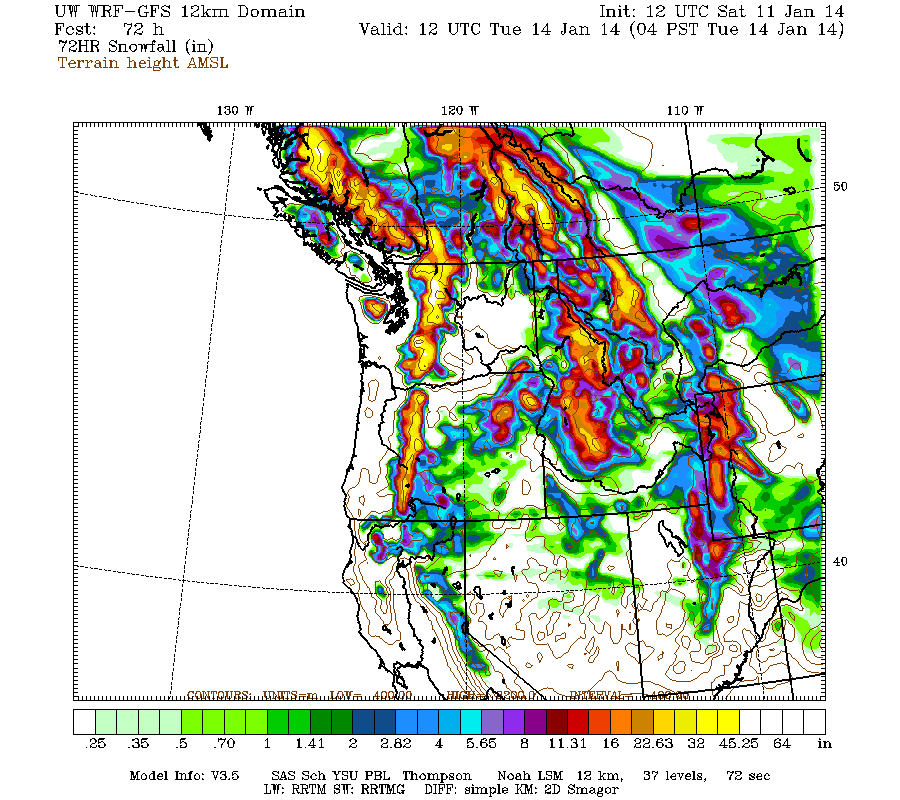
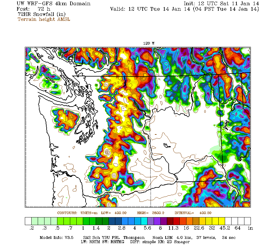
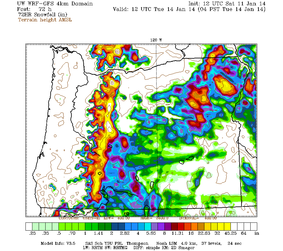
Additional snowfall during the 2 day period through 4am Tuesday is predicted to be 2-4 ft over the northern Washington Cascades (an increase from earlier predictions), with 1-2 ft for the southern Washington and Oregon Cascades, plus the west slopes of the Olympics (note the reduction in time period compared to graphics shown in update #5 above):
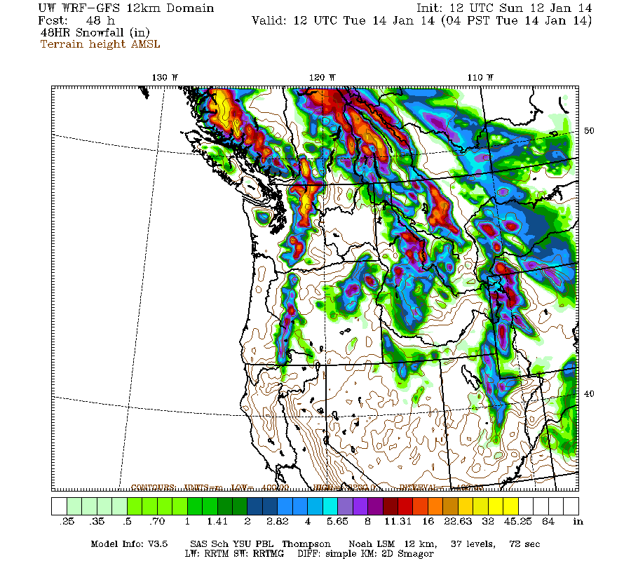
Higher resolution version of that, zoomed in on WA and OR:
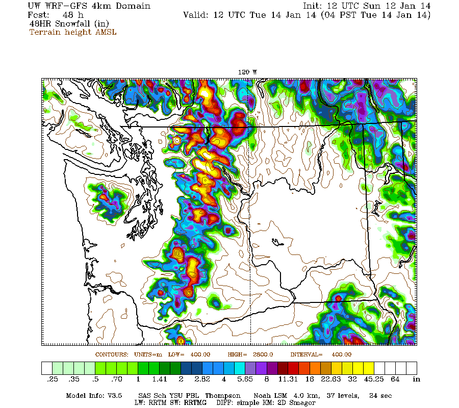
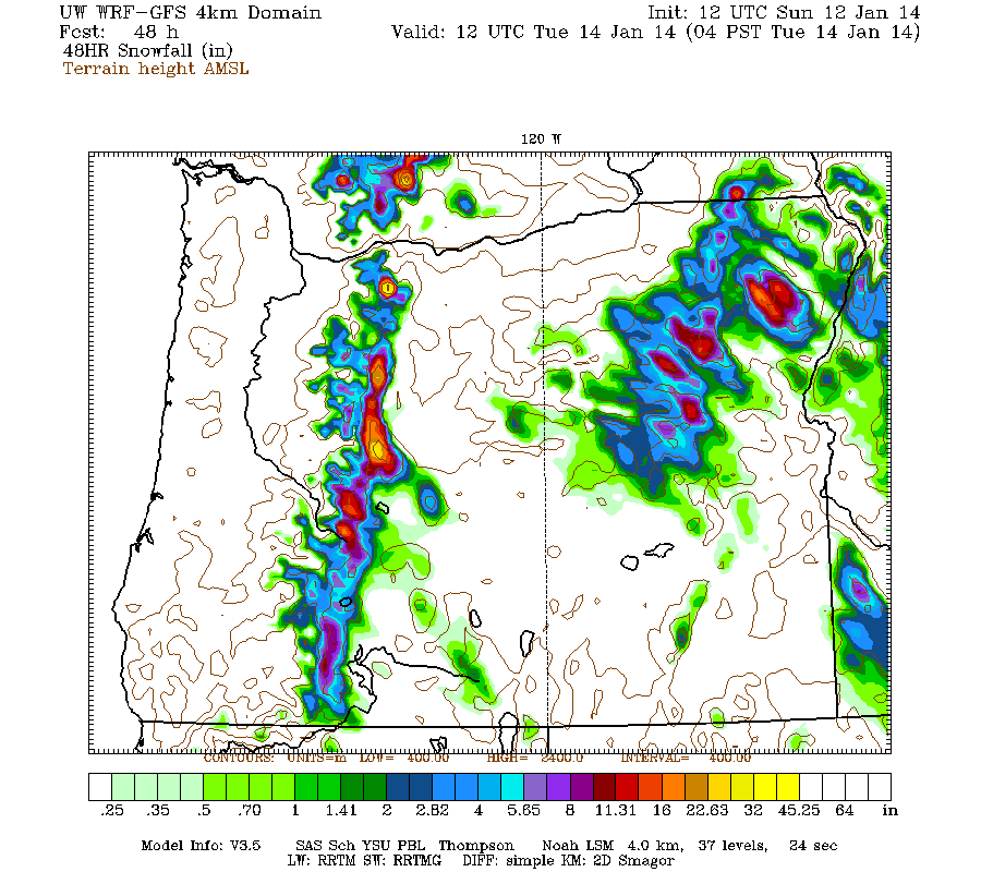
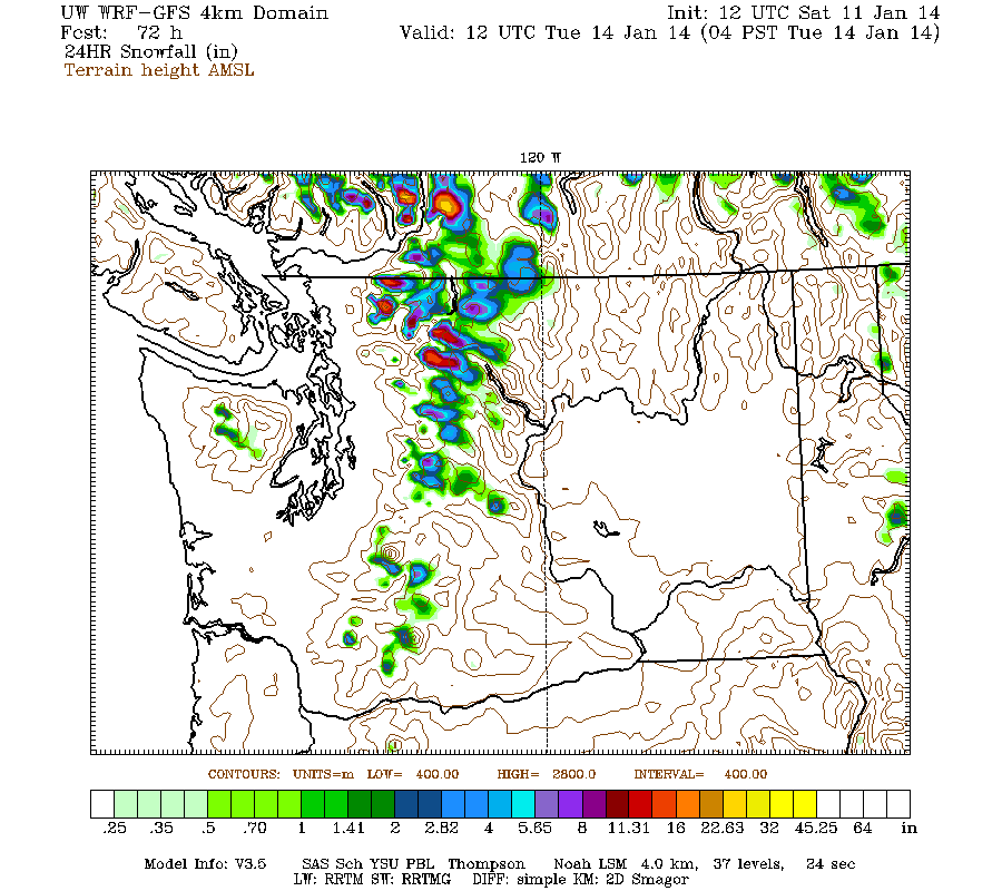
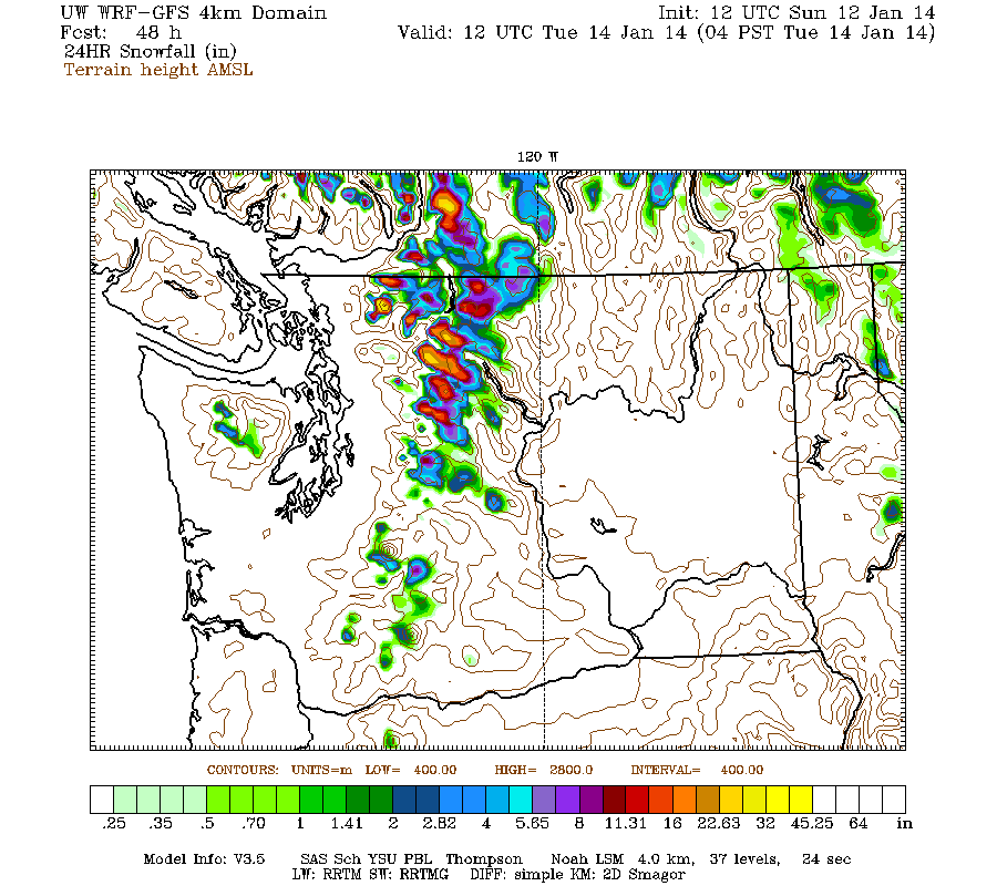
Almost all of that snowfall will have fallen before Monday morning, except in the North Cascades. During the last 24 hours of that period on Monday, the model now shows another 6-24" of snowfall over the northern Washington Cascades with snow levels rising to above 4000 ft, with barely a few inches more for the Olympics and southern Washington, and almost nothing in Oregon:
The persistent ridge of high pressure off the West Coast will rebuild northward during the early part of next week, bringing this storm cycle to an end. However, it should also bring several days of mostly sunny warm weather during the upcoming week, mainly Tuesday-Friday and especially south -- probably ideal conditions for ski mountaineering on above-treeline, avy-safe terrain on the volcanoes.
Details beyond that point remain murky and very uncertain as of now, with subsequent runs of the extended GFS model shifting around predictions during the 7-16 day time frame. Best to wait a few more days until the high pressure rebuilds midweek, to see if models become more consistent in their predictions for the week after that.
Another day later, and 2 more subsequent runs of the UW WRF-GFS model at 12-hour intervals continue to show similar predictions for ongoing snowfall through the rest of this weekend. This storm cycle has proceeded largely as predicted several days prior to its start by the models, and it really is a stunning success that weather models could quite accurately predict this event from 5-7 days out, including reasonably correct snowfall amounts. Forecasting precip amounts accurately is quite difficult (much more so than temperature or wind), and doing so for snowfall amounts is even more difficult.
The strongest system of this storm cycle arrived Friday afternoon into Saturday, with heavy precip and snowfall. The strong leading warm front passed through on Friday afternoon, with heavy rain falling up to 6000-7000 ft (except 4500-5000 ft in northernmost WA and southwest BC) on Friday night as predicted, and then the strong trailing cold front passed through during the early hours of Saturday before sunrise, lowering snow levels dramatically to about 3000 ft with heavy snowfall throughout the rest of Saturday. On Saturday afternoon for a few hours, snowfall from this single system extended over an 1100-mile stretch (as the crow flies, or 1500+ miles by car ) of the West Coast from the mountains near Bella Coola, BC, to Mammoth Mountain, CA, in the eastern Sierra Nevada (although snowfall amounts were barely a few inches anywhere in California). A very extensive storm system!
Higher elevation sites in northernmost Washington and southwest BC that remained all snow during the warm portion of the system received 2-3 ft of snowfall in 24 hours by Saturday evening. Whistler Mountain reported 19" new at their 5400 ft snowfall plot on Saturday morning and 25" by Saturday afternoon (after getting only a few inches during the first 3 days of the storm cycle), although it was mostly rain lower down and in the Village. The nearby Squamish River BCRFC site stayed all snow despite its modest 4500 ft elevation, and got 3 ft of new snow. The Chilliwack River BCRFC site at 5300 ft in the BC Cascades just north of the US border near Mount Baker became the first telemetry site in the Cascades to reach 100" of snowdepth (and the first in North America as far as I know) on Saturday afternoon, followed a few hours later by the Brown Top SNOTEL site at 5800 ft near Mount Redoubt in the North Cascades, which also got almost 3 ft in 24 hours:
[size=small][tt]SQUAMISH RIVER (UPPER) 1387 m (4550 ft)
Located 45 km (28 miles) NW of Mt Garibaldi
and 11 km (7 miles) WNW of Mt Cayley
Date Time Temp Rain Gauge SWE Snowdepth
(PST) (°C) (°F) (mm) (in) (mm) (in) (cm) (in)
2014-01-10 16:00 -3.0 26.6 898 35.4 394 15.5 146 57.5
2014-01-10 17:00 -3.3 26.1 899 35.4 395 15.6 147 57.9
2014-01-10 18:00 -3.5 25.7 900 35.4 397 15.6 148 58.3
2014-01-10 19:00 -3.6 25.5 901 35.5 398 15.7 149 58.7
2014-01-10 20:00 -3.7 25.3 903 35.6 403 15.9 775 305.1
2014-01-10 21:00 -3.6 25.5 907 35.7 411 16.2 156 61.4
2014-01-10 22:00 -3.5 25.7 911 35.9 418 16.5 158 62.2
2014-01-10 23:00 -3.5 25.7 915 36.0 427 16.8 162 63.8
2014-01-11 00:00 -3.5 25.7 919 36.2 434 17.1 168 66.1
2014-01-11 01:00 -3.6 25.5 924 36.4 443 17.4 172 67.7
2014-01-11 02:00 -3.3 26.1 930 36.6 451 17.8 178 70.1
2014-01-11 03:00 -2.8 27.0 937 36.9 459 18.1 186 73.2
2014-01-11 04:00 -1.9 28.6 942 37.1 464 18.3 182 71.7
2014-01-11 05:00 -1.4 29.5 946 37.2 467 18.4 775 305.1
2014-01-11 06:00 -1.5 29.3 947 37.3 468 18.4 775 305.1
2014-01-11 07:00 -1.6 29.1 947 37.3 469 18.5 189 74.4
2014-01-11 08:00 -2.5 27.5 948 37.3 470 18.5 191 75.2
2014-01-11 09:00 -2.5 27.5 948 37.3 470 18.5 185 72.8
2014-01-11 10:00 -2.6 27.3 948 37.3 472 18.6 775 305.1
2014-01-11 11:00 -2.9 26.8 950 37.4 477 18.8 191 75.2
2014-01-11 12:00 -2.9 26.8 954 37.6 482 19.0 200 78.7
2014-01-11 13:00 -2.7 27.1 957 37.7 486 19.1 207 81.5
2014-01-11 14:00 -2.6 27.3 959 37.8 488 19.2 202 79.5
2014-01-11 15:00 -2.6 27.3 961 37.8 489 19.3 210 82.7
2014-01-11 16:00 -2.8 27.0 962 37.9 491 19.3 212 83.5 <<< 26" snowdepth increase in 24 hours,
2014-01-11 17:00 -3.0 26.6 963 37.9 492 19.4 208 81.9 along with 3.8" SWE increase, implies
2014-01-11 18:00 -2.8 27.0 964 38.0 493 19.4 211 83.1 24 hour snowfall of about 3 ft !
2014-01-11 19:00 -3.2 26.2 964 38.0 493 19.4 210 82.7
2014-01-11 20:00 -3.4 25.9 964 38.0 493 19.4 208 81.9
2014-01-11 21:00 -4.4 24.1 964 38.0 493 19.4 209 82.3
2014-01-11 22:00 -3.9 25.0 964 38.0 493 19.4 208 81.9
2014-01-11 23:00 -3.9 25.0 964 38.0 493 19.4 207 81.5
CHILLIWACK RIVER 1621 m (5320 ft)
Located 29 km (18 miles) NNE of Mt Baker
and 4 km (2.5 miles) north of US border
Date Time Temp Rain Gauge SWE Snowdepth
(PST) (°C) (°F) (mm) (in) (mm) (in) (cm) (in)
2014-01-10 16:00 -3.7 25.3 1083 42.6 791 31.1 231 90.9
2014-01-10 17:00 -3.8 25.2 1083 42.6 793 31.2 232 91.3
2014-01-10 18:00 -3.5 25.7 1083 42.6 797 31.4 231 90.9
2014-01-10 19:00 -2.9 26.8 1082 42.6 799 31.5 234 92.1
2014-01-10 20:00 -2.5 27.5 1084 42.7 802 31.6 235 92.5
2014-01-10 21:00 -2.1 28.2 1083 42.6 805 31.7 236 92.9
2014-01-10 22:00 -1.1 30.0 1086 42.8 808 31.8 239 94.1
2014-01-10 23:00 -0.5 31.1 1086 42.8 814 32.0 239 94.1
2014-01-11 00:00 0.0 32.0 1084 42.7 819 32.2 239 94.1
2014-01-11 01:00 0.0 32.0 1086 42.8 822 32.4 239 94.1
2014-01-11 02:00 0.0 32.0 1091 43.0 827 32.6 240 94.5
2014-01-11 03:00 0.0 32.0 1111 43.7 832 32.8 239 94.1
2014-01-11 04:00 0.0 32.0 1112 43.8 836 32.9 241 94.9
2014-01-11 05:00 0.0 32.0 1112 43.8 842 33.1 242 95.3
2014-01-11 06:00 -1.9 28.6 1110 43.7 848 33.4 245 96.5
2014-01-11 07:00 -2.9 26.8 1110 43.7 854 33.6 540 212.6
2014-01-11 08:00 -3.1 26.4 1112 43.8 856 33.7 540 212.6
2014-01-11 09:00 -3.1 26.4 1112 43.8 859 33.8 540 212.6
2014-01-11 10:00 -3.2 26.2 1112 43.8 862 33.9 540 212.6
2014-01-11 11:00 -3.2 26.2 1112 43.8 864 34.0 251 98.8
2014-01-11 12:00 -3.0 26.6 1113 43.8 867 34.1 251 98.8
2014-01-11 13:00 -2.7 27.1 1114 43.9 868 34.2 251 98.8
2014-01-11 14:00 -3.1 26.4 1114 43.9 871 34.3 252 99.2
2014-01-11 15:00 -3.4 25.9 1114 43.9 872 34.3 252 99.2
2014-01-11 16:00 -3.4 25.9 1114 43.9 872 34.3 254 100.0 <<< first telemetry site in Cascades
2014-01-11 17:00 -3.6 25.5 1114 43.9 874 34.4 255 100.4 to reach 100" snowdepth (and first
2014-01-11 18:00 -3.8 25.2 1116 43.9 877 34.5 260 102.4 in North America as far as I know)
2014-01-11 19:00 -3.7 25.3 1116 43.9 880 34.6 263 103.5
2014-01-11 20:00 -3.7 25.3 1117 44.0 882 34.7 265 104.3
2014-01-11 21:00 -3.8 25.2 1116 43.9 883 34.8 266 104.7
2014-01-11 22:00 -4.4 24.1 1116 43.9 884 34.8 267 105.1
2014-01-11 23:00 -5.2 22.6 1112 43.8 888 35.0 266 104.7
BROWN TOP SNOTEL 5830 ft
Located 15 miles north of Diablo, 5 miles south of Canadian border
Snow Precip
Water Snow since Air Wind Wind Wind
Date / Time Equiv Depth Oct 1 Temp Avg Max Dir
(PST) (in) (in) (in) (°F) (mph) (mph) (°)
2014-01-10 20:00 22.9 80 20.2 28 4.6 6.8 210
2014-01-10 21:00 23.0 80 20.2 29 4.6 8.5 213
2014-01-10 22:00 23.2 81 20.3 31 4.7 7.8 174
2014-01-10 23:00 23.3 81 20.4 32 4.1 9.8 230
2014-01-11 00:00 23.4 82 20.4 32 5.6 13.5 239
2014-01-11 01:00 23.5 82 20.5 33 5.6 11.6 181
2014-01-11 02:00 23.8 20.6 33 5.9 16.2 229
2014-01-11 03:00 23.9 85 20.8 34 5.5 13.5 240
2014-01-11 04:00 24.0 20.7 33 4.2 12.5 185
2014-01-11 05:00 24.2 20.8 33 4.3 9.0 152
2014-01-11 06:00 24.4 89 20.9 32 4.9 9.6 250
2014-01-11 07:00 24.7 89 21.5 30 8.2 14.3 212
2014-01-11 08:00 24.9 93 21.6 28 9.9 17.1 254
2014-01-11 09:00 25.0 91 21.6 28 8.1 13.4 241
2014-01-11 10:00 25.2 21.8 27 6.7 15.5 184
2014-01-11 11:00 25.2 91 21.8 27 4.8 12.5 137
2014-01-11 12:00 25.3 91 21.8 27 3.0 6.7 144
2014-01-11 13:00 25.5 96 21.9 27 2.8 5.9 130
2014-01-11 14:00 25.6 94 22.0 27 4.0 8.1 210
2014-01-11 15:00 25.8 96 22.1 26 2.6 7.1 218
2014-01-11 16:00 25.8 96 22.1 26 4.1 10.8 235
2014-01-11 17:00 26.0 98 22.2 26 2.8 9.4 208
2014-01-11 18:00 26.1 99 22.2 26 7.9 13.8 127
2014-01-11 19:00 26.2 101 22.2 26 6.2 11.7 241 <<< second telemetry site in Cascades
2014-01-11 20:00 26.4 101 22.4 26 3.8 9.9 258 to reach 100" snowdepth
2014-01-11 21:00 26.5 102 22.5 26 4.0 9.5 254
2014-01-11 22:00 26.6 103 22.6 26 3.6 8.0 244 <<< 23" snowdepth increase in 24 hours,
2014-01-11 23:00 26.6 101 22.6 25 4.8 10.6 262 along with 3.7" SWE increase, implies
24 hour snowfall of almost 3 ft !
[/tt]
(The Flattop Mountain SNOTEL site at 6300 ft in Montana also reached 100" on Sunday morning due to this same storm cycle,
the first site outside the Cascades to do so, as far as I know -- there may be some other sites that I have missed.)[/size]
The last portion of the storm cycle is now underway on Sunday, starting with a period of extremely intense snowfall Sunday morning -- the climax of this entire storm cycle. Especially from the central WA Cascades south to the northern OR Cascades, snowfall rates of 2-4" per hour early Sunday morning produced another 6-12" of snow in only 4-5 hours at many sites, with 24 hour totals of 2 ft at many sites. Snow levels remained low at 2000-3000 ft during that intense snowburst, but are rising to 4000-5000 ft as another warm front approaches.
About 3-7 ft of new snow has already fallen during the 5 days since the storm cycle began early Tuesday, January 7. Total snowfall through mid-day Sunday has been about 3 ft at Whistler Mountain, 4.5 ft at Baker Ski Area, over 5 ft at Brown Top SNOTEL, 3 ft at Buckinghorse SNOTEL in the Olympics, about 1.5 ft at Hurricane Ridge, over 3 ft at Washington Pass, almost 4 ft at Stevens, barely 1 ft at Mission Ridge, 2.5 ft at Snoqualmie (almost tripling the previous snowdepth there at pass level) with about 4.5 ft at the top of Alpental, 2 ft at Crystal Mountain base with over 3 ft in Green Valley, 5 ft at Paradise, almost 4 ft at the top of White Pass, about 3 ft at 4000 ft on Mount Saint Helens, over 4 ft at Timberline and Mount Hood Meadows, and 3.5 ft at Mount Bachelor. Snowfall totals diminish rapidly farther south in Oregon, with about 2 ft at Willamette Pass and Crater Lake, and only about 1 ft at Mount McLoughlin, then truly plummet in California, with only about 2-5" new (all of which fell on Saturday) for Mount Shasta, Lassen Peak, and the Sierra Nevada.
Total precip through mid-day Sunday has been about 7" at Baker Ski Area and Brown Top SNOTEL, 9" at Buckinghorse SNOTEL in the Olympics, 3.5" at Hurricane Ridge (half rain) and Washington Pass (almost all snow), over 5.5" at Stevens, under 1.5" at Mission Ridge, about 7.5" at Snoqualmie, 3" at Crystal, 6.5" at Paradise, almost 5" at White Pass, about 9-11" on Mount Saint Helens, over 8" at Mount Hood Meadows, and almost 10" at Timberline on Hood. Given those precip amounts, snowfall totals of over 7 ft were likely received above 7000 ft on Mount Hood where the precip remained entirely snow, versus periods of mixed precip and extremely dense wet snowfall at Meadows and Timberline.
Snowdepths have increased substantially at most measurement sites in the Cascades and Olympics, doubling or even tripling at many sites especially at lower elevations and in Oregon. Snowdepth at Paradise broke 100" on Sunday morning, a very significant number since Paradise has reached 100" in every season except 2004-2005 when it maxed out at 95" (manual snowdepth records extend back to 1916 at Paradise, with only 3 missing years). Even in that year, the NWAC Paradise telemetry site may have topped 100" for about 20 hours on April 15-16, but the depth sensor had been very flaky throughout that spring, randomly fluctuating by 15-20", making the correct values uncertain. Snowdepth at Paradise is now roughly 100% of normal for this date! -- it's kind of shocking to see that, given how far below normal this season has been thus far (of course, obviously the new snowfall will rapidly settle and reduce the depth below 100% of normal in a few days -- but January snowdepth values often include much new unconsolidated snow like this). All other sites in the Cascades, Olympics, and southwest BC remain below 100% of normal snowdepth, but a few others are close especially farther north: Whistler Mountain, Baker Ski Area, and Stevens Pass are all roughly 90% of normal as of now.
One big Pacific Northwest storm cycle can really fix a low snowpack! And this was merely a big storm cycle, not a huge one at all -- huge Northwest storm cycles can deliver 10-15 ft of snow during 1 week.
Additional snowfall during the 2 day period through 4am Tuesday is predicted to be 2-4 ft over the northern Washington Cascades (an increase from earlier predictions), with 1-2 ft for the southern Washington and Oregon Cascades, plus the west slopes of the Olympics (note the reduction in time period compared to graphics shown in update #5 above):
Higher resolution version of that, zoomed in on WA and OR:
Almost all of that snowfall will have fallen before Monday morning, except in the North Cascades. During the last 24 hours of that period on Monday, the model now shows another 6-24" of snowfall over the northern Washington Cascades with snow levels rising to above 4000 ft, with barely a few inches more for the Olympics and southern Washington, and almost nothing in Oregon:
The persistent ridge of high pressure off the West Coast will rebuild northward during the early part of next week, bringing this storm cycle to an end. However, it should also bring several days of mostly sunny warm weather during the upcoming week, mainly Tuesday-Friday and especially south -- probably ideal conditions for ski mountaineering on above-treeline, avy-safe terrain on the volcanoes.
Details beyond that point remain murky and very uncertain as of now, with subsequent runs of the extended GFS model shifting around predictions during the 7-16 day time frame. Best to wait a few more days until the high pressure rebuilds midweek, to see if models become more consistent in their predictions for the week after that.
Please Log in or Create an account to join the conversation.