- Posts: 6
- Thank you received: 0
Major storm cycle brings 4-8 ft of snow Jan 7-14!
- elliotts
-

- User
-

Less
More
12 years 5 months ago #219657
by elliotts
Replied by elliotts on topic Re: Major storm cycle brings 4-8 ft of snow this week?
Amar - I have enjoyed reading this. Thanks for the detailed reports!
Please Log in or Create an account to join the conversation.
- Amar Andalkar
-
Topic Author
- User
-
Less
More
- Posts: 635
- Thank you received: 0
12 years 5 months ago - 12 years 5 months ago #219705
by Amar Andalkar
Replied by Amar Andalkar on topic Re: Major storm cycle brings 4-8 ft of snow this week?
Thanks for the kind words, friends. Although I analyze this weather data for my own education and knowledge, and write these posts largely for my own internal reasons, it is nice to see that others are actually reading the posts and getting some benefit out of them.
The "table of total snowfall and precip" above has been updated with a few more sites (manually-recorded NWS COOP sites like Holden Village, Government Camp, and Crater Lake Park HQ) for which the last week of data was not yet available from the NCDC until today, along with the (minimal and bleak) snowfall data from the Siskiyou Mountains in southernmost Oregon and from the California Cascades which I had originally omitted.
As of Wednesday January 15, the persistent ridge of high pressure off the West Coast has rebuilt strongly as predicted, and models now indicate that it will continue to persist for at least 1 more week, likely 2 weeks, and possibly even longer. This is the TOTAL PRECIP expected over the next 7 days (from www.wpc.ncep.noaa.gov/qpf/qpf2.shtml ):
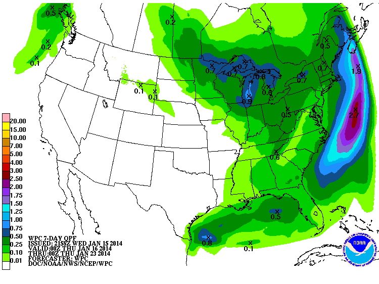
High and dry over the entire U.S. West Coast and even much of southwest BC! Time to make the best of it, and try to do those ski mountaineering trips (big, high, ambitious, etc.) which are impossible or impractical or unsafe during a normal winter.
Much more and interesting info about this highly unusual ridge and its ongoing effects can be found in the last several posts back to late 2013 on the California Weather Blog , written by a Stanford PhD candidate in atmospheric sciences.
The "table of total snowfall and precip" above has been updated with a few more sites (manually-recorded NWS COOP sites like Holden Village, Government Camp, and Crater Lake Park HQ) for which the last week of data was not yet available from the NCDC until today, along with the (minimal and bleak) snowfall data from the Siskiyou Mountains in southernmost Oregon and from the California Cascades which I had originally omitted.
As of Wednesday January 15, the persistent ridge of high pressure off the West Coast has rebuilt strongly as predicted, and models now indicate that it will continue to persist for at least 1 more week, likely 2 weeks, and possibly even longer. This is the TOTAL PRECIP expected over the next 7 days (from www.wpc.ncep.noaa.gov/qpf/qpf2.shtml ):
High and dry over the entire U.S. West Coast and even much of southwest BC! Time to make the best of it, and try to do those ski mountaineering trips (big, high, ambitious, etc.) which are impossible or impractical or unsafe during a normal winter.
Much more and interesting info about this highly unusual ridge and its ongoing effects can be found in the last several posts back to late 2013 on the California Weather Blog , written by a Stanford PhD candidate in atmospheric sciences.
Please Log in or Create an account to join the conversation.
- sheispiste
-

- User
-
Less
More
- Posts: 105
- Thank you received: 0
12 years 5 months ago #219706
by sheispiste
Replied by sheispiste on topic Re: Major storm cycle brings 4-8 ft of snow this week?
Amar,
As a science teacher/skier, I've read this thread with great interest, and passed it along to colleagues who teach earth and space science at the middle school and high school levels. We've all learned from this. Thank you.
Think Snow!
As a science teacher/skier, I've read this thread with great interest, and passed it along to colleagues who teach earth and space science at the middle school and high school levels. We've all learned from this. Thank you.
Think Snow!
Please Log in or Create an account to join the conversation.
- filbo
-
- User
-
Less
More
- Posts: 184
- Thank you received: 0
12 years 5 months ago #219713
by filbo
Replied by filbo on topic Re: Major storm cycle brings 4-8 ft of snow this week?
Thanks for the keen observations and the time you have put into understanding the weather and the forecasts. It is a big help when trying to figure out where to get the goods and when they are coming.
Please Log in or Create an account to join the conversation.
- andybrnr
-
- User
-
Less
More
- Posts: 25
- Thank you received: 0
12 years 5 months ago #219716
by andybrnr
Replied by andybrnr on topic Re: Major storm cycle brings 4-8 ft of snow this week?
Good summary, Amar. Muir could corn up this weekend with the high FRZ levels, as long as there's not too much mid level moisture keeping things cloudy, which is a possibility as the front off shore falls apart on Friday/Saturday. Skiability could get a little funky with the warm up on non-solar aspects that don't fully consolidate.
Andy
Andy
Please Log in or Create an account to join the conversation.
- RonL
-
- User
-
Less
More
- Posts: 259
- Thank you received: 0
12 years 5 months ago #219717
by RonL
Replied by RonL on topic Re: Major storm cycle brings 4-8 ft of snow this week?
This analysis is very appreciated. Thanks for sharing it.
Please Log in or Create an account to join the conversation.