TR Replies
Scott,
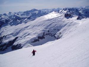
That north run was probably the other route up Mt Townsend. It's a bit faster and more direct, although a little steeper. It does, however, let you ski home. The north chutes are fun and yes a bit on the short side. They'll be around for a while - generally melt out in early June.
Bill G
That north run was probably the other route up Mt Townsend. It's a bit faster and more direct, although a little steeper. It does, however, let you ski home. The north chutes are fun and yes a bit on the short side. They'll be around for a while - generally melt out in early June.
Bill G
Nice report! I was under the impression that they didn't allow people with skis to buy a one ride ticket. It seems like I may have been wrong?
Thanks again to Ron, Jeanette, and everyone else for the good time - I'm looking forward to next year.
I've posted some of the better pics I took at:
http://community.webshots.com/album/135720477IwDrJa
The best, however, I think has to be this one of Kelvin:
http://home.comcast.net/~spavined/kelvin.jpg
See you in the hills.
-s
I've posted some of the better pics I took at:
http://community.webshots.com/album/135720477IwDrJa
The best, however, I think has to be this one of Kelvin:
http://home.comcast.net/~spavined/kelvin.jpg
See you in the hills.
-s
As a matter of fact, my first nomination for the "feature photo" in this thread is Paul's shot of the Skoogs:

That's the great Lowell Skoog on the mound, with Ken Madden trying to coach Lowell on how to make the snowballs a little more durable under the relentless bat of the ferocious Tom Skoog.
That's the great Lowell Skoog on the mound, with Ken Madden trying to coach Lowell on how to make the snowballs a little more durable under the relentless bat of the ferocious Tom Skoog.
My pics are at:
http://groups.msn.com/WildHeartsSkiing/pictures
(Please forgive the odd date stamp -- I was having a "bad battery" day >:( )
I'm certain some of the other shutterbugs must have got some cool party pics.
I'm thinking we should have a contest for the coolest/funniest/most unique skifest photo to be the "real" photo for this thread.
If everyone with photos posted their "entry photo" on this thread (along with a link to the rest of th...
Was a great time fo sure. Thanx to Ron J and Mad_Dog for arranging it. Was nice putting faces to all those creative poster names. I can't wait to see some of the hundreds of pictures that were shot that day. Till next time... ;D
Continuing after a inadvertant post !
We skied the whole classic banana. I'm hoping that area never becomes developed.After skiing we retired to a mass dinner in Eatonville basking in our sunburt faces and beer.
We skied the whole classic banana. I'm hoping that area never becomes developed.After skiing we retired to a mass dinner in Eatonville basking in our sunburt faces and beer.
Hey thanks, Amar! :)
I tried what you said and it looks like it cut about .5MB off the file size. I've never been pleased with the file sizes out of TOPO, but I think this is an improvement, for sure. I'll save them as .GIFs from now on and will probably redo the other maps on my site as well.
Thanks again for the input!
We are presently at Schat's Bakery in Bishop using our Sierra Wireless card in our laptop and a T-Mobile link to cruise the internet. A day off from skiing due to a storm in the Sierras. Love this wireless technology. Big high pressure system building on Tuesday. The Eastern Sierras are at their peak.
Zap
Zap
Great info, Amar.
That should certainly be encouraging for those that were planning in skiing St Helens this weekend.
That should certainly be encouraging for those that were planning in skiing St Helens this weekend.
I have a NOAA weather radio I got cheap at a garage sale. Sometimes it works, sometimes it doesn't, but most often I can pick up forecasts near cities. It's highly likely that mine is somehow broken and a new one might work better. It gives the same forecast on the National Weather Service web site, except vocalized through an automated computer voice.
I just added a map of our route to the last page of my TR...if anyone cares.
Sam, nice trip report. But that map file is really HUGE. May I make a suggestion about this map (and perhaps other maps on your site)? You should save them as GIF files instead of JPG, I think they'll be much smaller and also less blurry. Some maps compress acceptably in JPG format, but others do not. Let me try to explain what has happened in this case.
This map...
One question: You allude to getting weather forecasts while you are traveling. If you don't mind me asking, what is your source for accurate forecasts while you are on the road?
Well, the internet is the only place to find reasonably accurate forecasts. On previous long Cascades trips, I used to hunt around for internet cafes and public libraries with internet access in various nearby towns. But since I bring my ancient (circa 2000) laptop along...
Telemetry from the Swift Creek SNOTEL site shows that the south side of Mt Saint Helens has received close to 2 ft of new snow the past couple of days (above 3700 ft, with more rain & less snow below that). That is by far the most of any location in the Cascades during the current storm system, while the Oregon Cascades from Mt Hood all the way south to Crater Lake have also gotten close to 1 ft of new snow.
Great Pics, Jerry.
Hope you can do as well this Sunday at Crystal!!
http://www.turns-all-year.com/cgi-bin/yabb/YaBB.pl?board=ha3;action=display;num=1081524254
Hope you can do as well this Sunday at Crystal!!
http://www.turns-all-year.com/cgi-bin/yabb/YaBB.pl?board=ha3;action=display;num=1081524254
I think your last picture is the one that is suppose to accompany the route description by Burgdorfer. The picture in my edition was taken from Ruth Mountain.
You're in fine form on this report, Zap. Between you and Amar, I'm weeping softly over my keyboard.
Come home safe,
Mark
Come home safe,
Mark
Amar,
Thanks for theTR. Jill and I skied at Bachelor on the 7th and I passed the TH for McLoughlin that afternoon. I was tempted to tour there on the 8th but decided to try after our trip in the Eastern Sierras. Also plan to return to Lassen and ski the NW side this time. Jill has never skied Shasta so if the weather looks good we'll probably stop by there. The touring in the Tahoe and Eastern Sierras has been great. In 2005, you need to go a bit furthe...
Thanks for theTR. Jill and I skied at Bachelor on the 7th and I passed the TH for McLoughlin that afternoon. I was tempted to tour there on the 8th but decided to try after our trip in the Eastern Sierras. Also plan to return to Lassen and ski the NW side this time. Jill has never skied Shasta so if the weather looks good we'll probably stop by there. The touring in the Tahoe and Eastern Sierras has been great. In 2005, you need to go a bit furthe...
Thanks for the report Monika. A few additional comments:
This guy was really lucky. He had only minor facial abrasions and a badly cut lip, otherwise he was fine although in a bit of shock. I can't imagine riding into a creavasse, and how he managed to land safely on a ledge.
We were descending at about 2:00pm when we saw a crowd of snowmobilers hanging out below. They called over for help, asking if we had a rope. I realized at this point what had hap...
Um....this is why snowmobilers top the list in bc accidents during the winter. I am glad to hear that he lost his sled and not his life. Others are not so fortunate. Maybe that person will think twice next time and stay off glaciers jackass. On another note that's too bad that the USFS doens't enforce this. Nothing against snowmobilers (the ones with common sense anyway). I saw snowmobilers at Crystal last year and it just pissed me off! Loud, annoying, and tearing up the sub-alpine. Mad...
Paul Russell did report the incident to the Mt. Baker Ranger Station. Here is a link to a discussion of the incident including environmental considerations (or lack there of).
http://www.cascadeclimbers.com/threadz/showflat.php/Cat/0/Number/332925/page/0/view/collapsed/sb/5/o/all/fpart/1
http://www.cascadeclimbers.com/threadz/showflat.php/Cat/0/Number/332925/page/0/view/collapsed/sb/5/o/all/fpart/1
Wow! Kudos on the great trips, Amar! It's unfortunate about the weather.
One question: You allude to getting weather forecasts while you are traveling. If you don't mind me asking, what is your source for accurate forecasts while you are on the road?
Thanks!
One question: You allude to getting weather forecasts while you are traveling. If you don't mind me asking, what is your source for accurate forecasts while you are on the road?
Thanks!
Interesting report. I hope those in authority will note some of the specifics of your snowmobile incident and I hope that the cost of extricating / environmental damage of not extricating snow machines from wilderness volcanos will become a discussion point at higher levels of policy making. I've always believed that snow machines should be generally banned from anything above 6000 feet (*just to pick a number) in Washington state, but especially from being on crevassed glaciers. The other bad s...
Good question! Yeah, I mean from 29 Pines. This still puts us 1.5 miles shy of the Beverly Creek road (#112 spur) junction. Spur 112 is a little over a mile long to the summer trailhead parking lot.
The slopes below 5000 are definitely quite melted out. I think they look like about a month early from normal snow melt seasons. Snow pack above does appear like it will hold on for a while. Most major runs off the Teanaway peaks should hold up, I hope, 'till at least...
The slopes below 5000 are definitely quite melted out. I think they look like about a month early from normal snow melt seasons. Snow pack above does appear like it will hold on for a while. Most major runs off the Teanaway peaks should hold up, I hope, 'till at least...
After spending half an hour reading Sky's TR twice, I gotta chime in. Looks like you guys had a blast! I'm jealous. >:(
I guess that's why those skis are called "Scratch" BC's
yeah, it's still doable but hurry. a great time even without the grand prize. The bowl between iron and copper looked like a blast, we'll leave enough time for that next time. pics of the trip are at
http://community.webshots.com/album/134176120idsrng
http://community.webshots.com/album/134176120idsrng
Jerry ,
When we made our try of it we went in through Tahoma creek over suspension bridge and then south into indian henry's. About the same thing happend to us, it got slushy. Still doable this year right ? We also skied on Ararat,Copper and and flirted with the Pyramid glacier.
Got a killer place to camp up there.
Here're some pics from our trip, first one is skiing off the summit of Snowking with Mutchler in background and second is view looking back from approach, Mutchler on left, Snowking on right.

Brent, thanks for everything you have done for bc skiing in this area. Your trip reports from the eastern Alpine Lakes opened my eyes to the many possibilities in that region. And, as many people are probably aware, the existence of this TRs board is due to your years of running the TRs pages for the Mountaineers. It took me a while to catch on to how useful first-hand reports can be for planning a ski trip, but now I would feel lost without this kind of information (and probably would have much...
And it brings back memories of some of my earliest tours on my old wooden skis with my parents. Grover's only had a single pool back in the 70s, and it was gravel bottomed!
The snow pack on these sun exposed southerly slopes leading up to Cutthroat Peak seems a bit low. While skining up the steep slopes near 5700' I could see the ground at tree wells, so the depth was only a couple feet in these places. The weather the past month hasn't done much for the snow's staying power. It seems like we're in Summer already.
Zenom -- If I have identified the trees in the pic, we were skiing the headwall just to the West of you on Saturday morning. By noon it was getting sloppy, but the W. side of the same ridge softened sufficiently to restart the yoyo machine. Good stuff.
Big Snow -- the snow pack is about 5' at the road. South facing slopes tend to be rubbled severely on higher angle slopes, and north facing slopes have a bit of a crust problem. But you can work the aspects, ski E. facing slopes in th...
Big Snow -- the snow pack is about 5' at the road. South facing slopes tend to be rubbled severely on higher angle slopes, and north facing slopes have a bit of a crust problem. But you can work the aspects, ski E. facing slopes in th...
Jer - Speaking of pictures, I can't wait to see your pics from when we lowered you down into the cone ;) I would hate to think that I hauled that rope up there for nothing!! ???
Your TR brings back the memories of my pre-Californicating Oreghan existence. Carson Pass is a beautiful area. Kudos on a great tour!
Gaper Jeffeyyyyyyyy
Gaper Jeffeyyyyyyyy
Sounds like you hit it nicely!
Do you have any feeling for the snowpack in the area, say compared to last year or at least for its staying power?
Do you have any feeling for the snowpack in the area, say compared to last year or at least for its staying power?
Good trip you guy's! My pic's in a few days, been kinda busy. 8)
Sounds like a great trip, Zap.
Looking forward to the next report.
Looking forward to the next report.
You can at least check in here to see who is skiing ;D
Maybe see you at Battle Abbey!! Happy skiing ;)
Maybe see you at Battle Abbey!! Happy skiing ;)
Brent,
A few days ago Jill and I were driving past Mt. Shasta on our way to the eastern Sierras and it brought back memories of our ski descent of Shasta a few years ago.
I used to be an old eastern ski bum so I know you'll find plenty of places to make turns.
Keep turning them buddy - the alternatives are bleak.
Zap
Brent ,Although I've only known you peripherily you have had a big influnence on my activities and on the advancement of backcountry skiing in this locale.
this is not a obituary just a hearty thanks.
At some point back east you will run into DANA Dorsett
This email address is being protected from spambots. You need JavaScript enabled to view it.
Be sure a take a run with him.
this is not a obituary just a hearty thanks.
At some point back east you will run into DANA Dorsett
Be sure a take a run with him.
Brent,
You will be missed around here.
Who will lead the annual pilgrimage to Adams?
Daryl
You will be missed around here.
Who will lead the annual pilgrimage to Adams?
Daryl
hmmm, that's interesting. It could be their tracks (by the way, they were VERY nice tracks & it looked like maybe there was 3 of them), but for going through a few days of sunbaking, they sure looked fresh compared to the skin track of 1 week ago. I could be wrong...that's good to know about the N. Face because we were debating it. Based on what we had on White Salmon, I doubt it would have been any better.
Yep, couldn't have hit it any better, weather and snow coverage wise, even if we had known what we were doing 8)
Here's a shot of Jerry showing us how it's done:

The rest of the pics I got are at:
http://groups.msn.com/WildHeartsSkiing/pictures
Here's a shot of Jerry showing us how it's done:
The rest of the pics I got are at:
http://groups.msn.com/WildHeartsSkiing/pictures
I don't know if they were the tracks you saw, but I know my brother had descended White Salmon not this last weekend but on Apr. 4. I wasn't along, but the second hand report I got from him was that it was nice corn not far removed from powder, and that they actually turned around on a planned ascent/descent of N face due to scary perched windslab pack powder above 7K on that route and gone over to White Salmon as the secondary objective.
Good to see that you had a good trip up the Ingraham as well. Yeah, the skiing is definetely quite sketchyt in some of the sections.
The route that goes up on the left of the headwall and joins the Gib ledges route is not the "normal Ingraham route though, it is much steeper. Last week we saw tracks go up on the right side of the wall as you look towards the summit, which is not as steep acording to Mike Gauthier's book - don;t know how good it is for skiing though.
The route that goes up on the left of the headwall and joins the Gib ledges route is not the "normal Ingraham route though, it is much steeper. Last week we saw tracks go up on the right side of the wall as you look towards the summit, which is not as steep acording to Mike Gauthier's book - don;t know how good it is for skiing though.