- Posts: 165
- Thank you received: 1
WSDOT - Only 80" of Snow at Snoq Pass this Winter
- JPH
-

- User
-

Less
More
11 years 4 months ago #224324
by JPH
Thanks!
Replied by JPH on topic Re: WSDOT - Only 80" of Snow at Snoq Pass this Winter
Many of the stations are located in sheltered sites on generally flat ground. These locations improve accuracy of snowfall/precipitation measurements, though they often hold snow a bit longer than exposed sites. The Alpental station is located behind the main lodge. If the site hasn't been recently maintained then we may be seeing interference from brush
Thanks!
Please Log in or Create an account to join the conversation.
- Amar Andalkar
-
- User
-
Less
More
- Posts: 635
- Thank you received: 0
11 years 3 months ago - 11 years 3 months ago #224395
by Amar Andalkar
So maybe statistics are pretty useful for this sort of thing?! The roughly 50% statistical chance of breaking 100" did in fact come true, despite all meteorological indications to the contrary. All it took was one strong convergence-zone snowstorm on the night of March 31 to April 1, with snowfall rates of 2-3" per hour for a few hours at its peak, and 15" new for the day. From www.wsdot.com/winter/snoqualmie/ :
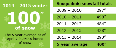
The current season total of 100" is still about 2.4 standard deviations below the median (413" over the full period of record with a standard deviation of 130"), which is in the 0.8 percentile, or roughly 1 in 120 years!
On a side note, it looks like Snoqualmie Pass will make it through this entire season with ZERO hours of avalanche-control closures:
Here's the recent daily snowfall from i90.atmos.washington.edu/roadview/avalanche/hyak.htm (note that it's not measured at Hyak, but at Snoqualmie Pass 3000 ft):
[tt]
Snoqualmie Snowfall Report
Courtesy of WSDOT Hyak Operation Center
Date New Snow Snow Depth
Mon Apr 13 0 in 0 in
Sat Apr 11 0 in 0 in
Thu Apr 09 0 in 0 in
Wed Apr 08 0 in 0 in
Tue Apr 07 0 in 0 in
Mon Apr 06 0 in 0 in
Fri Apr 03 0 in 4 in
Thu Apr 02 1 in 9 in <<< Reaches 100" for season!
Wed Apr 01 15 in 15 in
Tue Mar 31 0 in 0 in
Fri Mar 27 0 in 0 in
Wed Mar 25 3 in 3 in
Tue Mar 24 1 in 1 in <<< First snowfall in March!
Mon Mar 23 0 in 0 in
Fri Mar 20 0 in 0 in
Thu Mar 19 0 in 0 in
Wed Mar 18 0 in 0 in
Tue Mar 17 0 in 0 in
[/tt]
Although the Puget Sound convergence zone was kind to Snoqualmie that time, this weekend it missed Snoqualmie entirely, staying farther north and dumping 16" new at Stevens Pass from midday on April 11 into April 12, with similar snowfall rates of 2-3" per hour at its peak. Snoqualmie got relatively little precip from the weekend storm, almost all of which fell as rain at pass level, with only trace amounts of snow.
And here's the NWAC telemetry at Snoqualmie and Alpental over the 2-day period of that March 31 to April 1 storm, saved for posterity:
[tt]
Northwest Avalanche Center
Washington Department of Transportation
Snoqualmie Pass, Washington
3770' temp above Lake Keechelus snow shed
MM/DD Hour Temp Temp Temp RH Wind Wind Wind Hour Total 24 Hr Total Press
PST F F F % Avg Max Dir Prec. Prec. Snow Snow mb
3760' 3770' 3010' 3010' 3760' 3760' 3760' 3010' 3010' 3010' 3010' 3010'
3 31 500 35 34 36 94 21 37 262 .04 .04 0 0 1013
3 31 600 33 32 35 93 24 47 250 .01 .05 0 1 1014
3 31 700 32 31 35 96 15 28 247 .03 .08 0 0 1014
3 31 800 31 31 33 96 12 20 246 .05 .13 0 0 1015
3 31 900 30 31 33 95 18 27 250 .05 .18 0 0 1016
3 31 1000 31 32 37 92 13 24 257 0 .18 0 -0 1016
3 31 1100 31 33 35 93 10 15 250 .02 .2 0 0 1017
3 31 1200 31 34 34 96 8 13 249 .09 .29 0 1 1017
3 31 1300 32 34 37 94 6 14 256 .02 .31 0 0 1017
3 31 1400 32 31 33 96 14 45 -7999 .04 .35 0 1 1018
3 31 1500 31 30 32 97 14 23 280 .07 .42 0 1 1018
3 31 1600 32 31 32 97 12 19 272 .04 .46 0 0 1018
3 31 1700 31 31 32 97 9 18 249 .07 .53 0 0 1018
3 31 1800 30 31 32 98 5 15 246 .09 .62 0 0 1018
3 31 1900 29 30 31 98 8 19 -7999 .13 .75 2 4 1019
3 31 2000 30 30 31 98 5 13 -7999 .16 .91 2 4 1019
3 31 2100 30 30 32 98 7 16 309 .14 1.05 3 -165 1019
3 31 2200 30 30 31 98 9 20 286 .15 1.2 5 -165 1020
3 31 2300 29 30 31 98 11 18 270 .14 1.34 8 9 1020
4 1 0 30 30 31 98 8 17 -7999 .11 1.45 10 13 1020
4 1 100 30 29 31 98 15 24 253 .14 1.59 10 13 1020
4 1 200 30 29 30 98 14 31 259 .11 1.7 10 14 1021
4 1 300 29 29 31 98 9 15 257 .13 1.83 11 13 1021
4 1 400 28 29 30 98 11 16 254 .14 1.97 10 14 1021
4 1 500 29 29 30 98 7 16 252 .17 .17 0 14 1021
4 1 600 28 29 30 98 11 21 254 .08 .25 0 15 1022
4 1 700 29 29 32 97 7 12 253 .03 .28 0 14 1022
4 1 800 30 30 33 95 8 11 256 .06 .34 0 14 1022
4 1 900 30 33 36 86 10 17 250 .03 .37 0 13 1023
4 1 1000 31 34 37 87 11 19 248 0 .37 0 12 1023
4 1 1100 32 32 39 82 7 16 265 0 .37 0 13 1023
4 1 1200 32 34 38 83 3 8 -7999 0 .37 0 10 1023
4 1 1300 33 35 42 75 6 18 264 0 .37 -0 9 1022
4 1 1400 32 35 45 70 8 13 -7999 0 .37 0 8 1022
4 1 1500 33 35 39 82 12 22 249 0 .37 0 9 1022
4 1 1600 32 32 36 92 8 17 270 .01 .38 0 9 1022
4 1 1700 31 33 35 94 8 15 247 .03 .41 0 10 1022
4 1 1800 31 31 35 93 10 18 255 .02 .43 0 9 1022
4 1 1900 31 31 32 97 15 22 249 .01 .44 0 9 1023
4 1 2000 31 30 32 97 12 19 250 .03 .47 0 9 1023
4 1 2100 30 30 32 97 12 19 255 .02 .49 0 9 1023
4 1 2200 29 30 31 98 8 15 244 0 .49 0 9 1024
4 1 2300 30 29 31 98 9 15 258 0 .49 0 8 1024
4 2 0 29 29 31 98 7 13 253 0 .49 0 9 1024
4 2 100 29 29 32 98 9 13 246 0 .49 0 8 1024
4 2 200 29 29 32 98 8 15 242 0 .49 0 8 1024
4 2 300 29 30 32 98 7 11 243 0 .49 0 8 1024
4 2 400 29 29 31 98 8 12 235 0 .49 0 8 1024
Northwest Avalanche Center
Alpental Ski Area, Washington
Wind gages unheated and may rime
5470' Intermittent snow out
MM/DD Hour Temp Temp Temp RH RH Wind Wind Wind Hour Total 24 Hr Total 24 Hr Total Inter
PST F F F % % Avg Max Dir. Prec. Prec. Snow Snow Snow Snow Snow
5470' 4350' 3100' 3100' 5470' 5520' 5520' 5520' 3100' 3100' 3100' 3100' 4350' 4350' 5470'
3 31 500 28 33 37 96 100 26 45 235 .03 .03 0 13 0 25 39
3 31 600 26 32 36 97 99 20 37 235 .01 .04 0 13 0 24 37
3 31 700 26 32 35 98 100 19 32 234 .02 .06 0 14 0 21 39
3 31 800 27 31 33 99 99 14 24 234 .08 .14 0 14 1 21 39
3 31 900 27 31 34 99 98 18 31 234 .05 .19 0 14 2 22 38
3 31 1000 29 33 36 92 96 19 33 235 .01 .2 0 13 2 283 35
3 31 1100 28 33 35 96 97 15 27 236 .01 .21 0 13 2 283 29
3 31 1200 29 32 34 98 97 16 31 236 .09 .3 0 13 2 283 27
3 31 1300 27 34 36 96 98 20 36 235 .02 .32 0 13 2 23 17
3 31 1400 26 32 33 98 99 20 40 238 .05 .37 0 13 2 23 -27
3 31 1500 26 32 33 99 99 16 26 234 .06 .43 0 12 4 283 -170
3 31 1600 26 32 33 99 99 17 31 234 .04 .47 1 14 4 24 -224
3 31 1700 26 31 33 99 98 11 21 237 .09 .56 1 12 5 283 -132
3 31 1800 25 30 33 99 98 11 24 234 .12 .68 0 14 5 26 -74
3 31 1900 24 29 32 99 98 11 14 241 .13 .81 0 17 7 28 -39
3 31 2000 25 29 33 100 98 7 11 237 .15 .96 4 16 7 27 -18
3 31 2100 24 29 32 99 98 9 21 234 .12 1.08 4 18 8 32 -6
3 31 2200 24 29 33 100 99 11 16 235 .17 1.25 6 20 11 283 4
3 31 2300 24 29 32 100 99 10 20 232 .14 1.39 8 26 14 283 9
4 1 0 24 29 32 100 98 13 22 228 .12 1.51 8 29 16 39 10
4 1 100 24 29 32 100 99 15 27 235 .16 1.67 8 28 17 41 -51
4 1 200 24 28 32 100 99 16 28 234 .11 1.78 8 28 17 283 -31
4 1 300 24 28 32 100 99 15 32 233 .13 1.91 8 21 17 283 -16
4 1 400 23 28 31 100 98 14 26 234 .14 2.05 7 28 17 283 -6
4 1 500 23 28 32 99 98 11 19 234 .14 .14 8 28 18 283 1
4 1 600 24 28 31 100 98 11 28 234 .09 .23 0 28 18 283 7
4 1 700 24 28 33 98 99 12 23 233 .06 .29 0 31 18 41 11
4 1 800 26 29 33 95 99 10 20 234 .04 .33 0 33 18 283 13
4 1 900 31 32 34 95 99 10 17 233 .02 .35 0 32 18 283 12
4 1 1000 32 33 35 93 98 7 13 234 .02 .37 0 32 0 42 7
4 1 1100 34 35 39 85 98 11 20 234 .02 .39 -0 59 0 41 -20
4 1 1200 33 35 39 86 93 8 15 236 .01 .4 -0 66 0 36 -45
4 1 1300 34 36 39 88 91 10 19 237 0 .4 0 72 0 38 -32
4 1 1400 35 37 39 85 89 10 21 248 .01 .41 0 74 0 35 -26
4 1 1500 30 36 39 89 94 8 15 254 0 .41 0 74 0 38 -78
4 1 1600 28 34 35 94 97 11 20 250 .02 .43 0 75 0 36 -10
4 1 1700 29 33 34 95 95 11 18 235 .02 .45 0 75 0 283 2
4 1 1800 28 32 34 96 97 12 20 237 .03 .48 0 75 1 283 7
4 1 1900 26 31 33 98 98 13 22 232 .04 .52 0 75 0 283 -80
4 1 2000 26 31 33 98 99 14 26 247 .04 .56 0 75 2 283 -67
4 1 2100 25 30 33 99 98 16 27 291 .02 .58 0 72 2 283 -29
4 1 2200 24 29 32 99 97 16 28 345 0 .58 0 74 2 283 -13
4 1 2300 23 28 32 100 99 18 26 345 0 .58 0 74 2 41 -8
4 2 0 23 28 32 99 97 18 27 347 0 .58 0 74 2 42 -6
4 2 100 24 28 32 99 98 12 20 348 0 .58 0 74 2 41 -4
4 2 200 24 29 32 99 98 7 17 325 0 .58 0 74 2 41 -4
4 2 300 24 29 32 99 98 12 23 345 0 .58 0 74 2 38 -4
4 2 400 24 29 32 99 97 7 14 327 0 .58 0 74 2 38 -5
[/tt]
Glaciers may not lie, but they may instead be telling us something different than what we might initially assume.
Clearly glacial recession is proof of a significant decline in snowpack -- but snowpack on what date, and at what elevation? Glacier mass balance depends only on the snowpack remaining in the accumulation zone as of the end of summer, prior to start of the next season's snowfall. At elevations above 6500-8000 ft in the Cascades where the accumulation zones of all glaciers in the range sit, that date is sometime from about September to October in most years, and as late as November in rare years with extremely dry September-Octobers. Only the snowpack which exists in its accumulation zone matters to a glacier's health, while snowpack lower down on the glacier has almost no effect, and snowpack below or off the glacier none at all.
It is well known that glacial mass balance, and glacial recession or expansion, depend very strongly on summer temperatures and cloudiness. A very cool cloudy summer such as the one we had in 2010 following a fairly average snowpack season can result in significant positive mass balance. Much more so than other years like 2008 which by any measure was a huge snowpack year in the Northwest, especially so at low elevations, but with normal warm summer weather resulted in much less gains for the glaciers. An extended pattern of very cool and cloudy summers can result in significant glacial expansion, even with no increase in wintertime snowpack above average levels over that period, while a run of hot sunny dry summers will cause significant glacial recession even if the preceding winter snowpacks were all well above-normal.
So glacial mass balance and glacial recession really tell us nothing about the overall winter snowpack, or at most very little, and they tell us absolutely nothing about the low-elevation snowpack (roughly 1500-3500 ft in the WA Cascades) and even the mid-elevation snowpack (roughly 3500-5500 ft), which lie far below their accumulation zones. As we have seen so clearly during the 2014-15 season, the low-elevation snowpack (extremely below-normal this year) can be highly uncorrelated from the mid- and high-elevation snowpack (way closer to normal this year above 5000 ft), and that relative lack of correlation holds true in many other seasons too, albeit to a lesser degree than this freakish season.
Replied by Amar Andalkar on topic Re: WSDOT - Only 80" of Snow at Snoq Pass this Winter
...
So what about the snowfall this year: obviously a freakish anomaly of the highest order, especially so at Snoqualmie Pass. With 1" of new snowfall recorded today (the first snowfall there in the entire month of March!?!), the total now stands at 81". How likely is significant additional snowfall? Current forecasts for the next week pretty much rule out additional snowfall this month at Snoqualmie, although heavy precip is certain for tomorrow, along with significant snowfall at higher elevations, and there may be a couple more systems on Friday and Monday which bring snow higher up. So on to April and May:
Average snowfall at Snoqualmie Pass in April and May is about 30" as shown in the data, but median snowfall is only 20" with a standard deviation of almost 30". The maximum April-May snowfall is 97" (in April 1955, followed by 0" that May), while the minimum April-May snowfall is 0" in several years. Which is to say, spring snowfall at Snoqualmie Pass is extremely fickle and variable, and quite likely to end up under 20". Since the median is 20", statistically there is only about a 50% chance of Snoqualmie breaking 100" this season. Given the lack of any indication from climate models of a cooler and wetter than normal April this year, the real chance is probably well under 50% at this point. And the likelihood of this year matching the previous record low of 172" is minuscule, statistically on the order of 1%, and realistically well under that.
Assuming it does end up under 100", how unusual, how statistically unlikely would such a total be? The previous record low in a complete season was 172" in 1941-42, trailed closely by 196" in 1940-41 and 191" in 1976-77. So a sub-100" snowfall would be a very extreme outlier at roughly half the previous low. Given the median snowfall of 413" over the full period of record with a standard deviation of 130", a total of 90" would be about 2.5 standard deviations below the median, which is in the 0.6 percentile, or roughly 1 in 160 years!!
That's all based on a normal distribution though, and annual snowfall totals are not "normally" distributed, but it's good enough for a rough approximation of how unlikely a sub-100" snowfall total would be. To verify that, let's see how many years fall under 220", which is 1.5 standard deviations below the median, or 6.7 percentile, roughly 1 in 15 years. Out of the 95 complete years, 6 of them are under 220", which matches the statistical expectation well. So this calculation method seems reasonable despite the snowfall totals not being normally distributed. And given that there are nearly 100 years of data, it's quite reasonable to encounter a 1 in 160 year event in such a data set.
So maybe statistics are pretty useful for this sort of thing?! The roughly 50% statistical chance of breaking 100" did in fact come true, despite all meteorological indications to the contrary. All it took was one strong convergence-zone snowstorm on the night of March 31 to April 1, with snowfall rates of 2-3" per hour for a few hours at its peak, and 15" new for the day. From www.wsdot.com/winter/snoqualmie/ :
The current season total of 100" is still about 2.4 standard deviations below the median (413" over the full period of record with a standard deviation of 130"), which is in the 0.8 percentile, or roughly 1 in 120 years!
On a side note, it looks like Snoqualmie Pass will make it through this entire season with ZERO hours of avalanche-control closures:
Here's the recent daily snowfall from i90.atmos.washington.edu/roadview/avalanche/hyak.htm (note that it's not measured at Hyak, but at Snoqualmie Pass 3000 ft):
[tt]
Snoqualmie Snowfall Report
Courtesy of WSDOT Hyak Operation Center
Date New Snow Snow Depth
Mon Apr 13 0 in 0 in
Sat Apr 11 0 in 0 in
Thu Apr 09 0 in 0 in
Wed Apr 08 0 in 0 in
Tue Apr 07 0 in 0 in
Mon Apr 06 0 in 0 in
Fri Apr 03 0 in 4 in
Thu Apr 02 1 in 9 in <<< Reaches 100" for season!
Wed Apr 01 15 in 15 in
Tue Mar 31 0 in 0 in
Fri Mar 27 0 in 0 in
Wed Mar 25 3 in 3 in
Tue Mar 24 1 in 1 in <<< First snowfall in March!
Mon Mar 23 0 in 0 in
Fri Mar 20 0 in 0 in
Thu Mar 19 0 in 0 in
Wed Mar 18 0 in 0 in
Tue Mar 17 0 in 0 in
[/tt]
Although the Puget Sound convergence zone was kind to Snoqualmie that time, this weekend it missed Snoqualmie entirely, staying farther north and dumping 16" new at Stevens Pass from midday on April 11 into April 12, with similar snowfall rates of 2-3" per hour at its peak. Snoqualmie got relatively little precip from the weekend storm, almost all of which fell as rain at pass level, with only trace amounts of snow.
And here's the NWAC telemetry at Snoqualmie and Alpental over the 2-day period of that March 31 to April 1 storm, saved for posterity:
[tt]
Northwest Avalanche Center
Washington Department of Transportation
Snoqualmie Pass, Washington
3770' temp above Lake Keechelus snow shed
MM/DD Hour Temp Temp Temp RH Wind Wind Wind Hour Total 24 Hr Total Press
PST F F F % Avg Max Dir Prec. Prec. Snow Snow mb
3760' 3770' 3010' 3010' 3760' 3760' 3760' 3010' 3010' 3010' 3010' 3010'
3 31 500 35 34 36 94 21 37 262 .04 .04 0 0 1013
3 31 600 33 32 35 93 24 47 250 .01 .05 0 1 1014
3 31 700 32 31 35 96 15 28 247 .03 .08 0 0 1014
3 31 800 31 31 33 96 12 20 246 .05 .13 0 0 1015
3 31 900 30 31 33 95 18 27 250 .05 .18 0 0 1016
3 31 1000 31 32 37 92 13 24 257 0 .18 0 -0 1016
3 31 1100 31 33 35 93 10 15 250 .02 .2 0 0 1017
3 31 1200 31 34 34 96 8 13 249 .09 .29 0 1 1017
3 31 1300 32 34 37 94 6 14 256 .02 .31 0 0 1017
3 31 1400 32 31 33 96 14 45 -7999 .04 .35 0 1 1018
3 31 1500 31 30 32 97 14 23 280 .07 .42 0 1 1018
3 31 1600 32 31 32 97 12 19 272 .04 .46 0 0 1018
3 31 1700 31 31 32 97 9 18 249 .07 .53 0 0 1018
3 31 1800 30 31 32 98 5 15 246 .09 .62 0 0 1018
3 31 1900 29 30 31 98 8 19 -7999 .13 .75 2 4 1019
3 31 2000 30 30 31 98 5 13 -7999 .16 .91 2 4 1019
3 31 2100 30 30 32 98 7 16 309 .14 1.05 3 -165 1019
3 31 2200 30 30 31 98 9 20 286 .15 1.2 5 -165 1020
3 31 2300 29 30 31 98 11 18 270 .14 1.34 8 9 1020
4 1 0 30 30 31 98 8 17 -7999 .11 1.45 10 13 1020
4 1 100 30 29 31 98 15 24 253 .14 1.59 10 13 1020
4 1 200 30 29 30 98 14 31 259 .11 1.7 10 14 1021
4 1 300 29 29 31 98 9 15 257 .13 1.83 11 13 1021
4 1 400 28 29 30 98 11 16 254 .14 1.97 10 14 1021
4 1 500 29 29 30 98 7 16 252 .17 .17 0 14 1021
4 1 600 28 29 30 98 11 21 254 .08 .25 0 15 1022
4 1 700 29 29 32 97 7 12 253 .03 .28 0 14 1022
4 1 800 30 30 33 95 8 11 256 .06 .34 0 14 1022
4 1 900 30 33 36 86 10 17 250 .03 .37 0 13 1023
4 1 1000 31 34 37 87 11 19 248 0 .37 0 12 1023
4 1 1100 32 32 39 82 7 16 265 0 .37 0 13 1023
4 1 1200 32 34 38 83 3 8 -7999 0 .37 0 10 1023
4 1 1300 33 35 42 75 6 18 264 0 .37 -0 9 1022
4 1 1400 32 35 45 70 8 13 -7999 0 .37 0 8 1022
4 1 1500 33 35 39 82 12 22 249 0 .37 0 9 1022
4 1 1600 32 32 36 92 8 17 270 .01 .38 0 9 1022
4 1 1700 31 33 35 94 8 15 247 .03 .41 0 10 1022
4 1 1800 31 31 35 93 10 18 255 .02 .43 0 9 1022
4 1 1900 31 31 32 97 15 22 249 .01 .44 0 9 1023
4 1 2000 31 30 32 97 12 19 250 .03 .47 0 9 1023
4 1 2100 30 30 32 97 12 19 255 .02 .49 0 9 1023
4 1 2200 29 30 31 98 8 15 244 0 .49 0 9 1024
4 1 2300 30 29 31 98 9 15 258 0 .49 0 8 1024
4 2 0 29 29 31 98 7 13 253 0 .49 0 9 1024
4 2 100 29 29 32 98 9 13 246 0 .49 0 8 1024
4 2 200 29 29 32 98 8 15 242 0 .49 0 8 1024
4 2 300 29 30 32 98 7 11 243 0 .49 0 8 1024
4 2 400 29 29 31 98 8 12 235 0 .49 0 8 1024
Northwest Avalanche Center
Alpental Ski Area, Washington
Wind gages unheated and may rime
5470' Intermittent snow out
MM/DD Hour Temp Temp Temp RH RH Wind Wind Wind Hour Total 24 Hr Total 24 Hr Total Inter
PST F F F % % Avg Max Dir. Prec. Prec. Snow Snow Snow Snow Snow
5470' 4350' 3100' 3100' 5470' 5520' 5520' 5520' 3100' 3100' 3100' 3100' 4350' 4350' 5470'
3 31 500 28 33 37 96 100 26 45 235 .03 .03 0 13 0 25 39
3 31 600 26 32 36 97 99 20 37 235 .01 .04 0 13 0 24 37
3 31 700 26 32 35 98 100 19 32 234 .02 .06 0 14 0 21 39
3 31 800 27 31 33 99 99 14 24 234 .08 .14 0 14 1 21 39
3 31 900 27 31 34 99 98 18 31 234 .05 .19 0 14 2 22 38
3 31 1000 29 33 36 92 96 19 33 235 .01 .2 0 13 2 283 35
3 31 1100 28 33 35 96 97 15 27 236 .01 .21 0 13 2 283 29
3 31 1200 29 32 34 98 97 16 31 236 .09 .3 0 13 2 283 27
3 31 1300 27 34 36 96 98 20 36 235 .02 .32 0 13 2 23 17
3 31 1400 26 32 33 98 99 20 40 238 .05 .37 0 13 2 23 -27
3 31 1500 26 32 33 99 99 16 26 234 .06 .43 0 12 4 283 -170
3 31 1600 26 32 33 99 99 17 31 234 .04 .47 1 14 4 24 -224
3 31 1700 26 31 33 99 98 11 21 237 .09 .56 1 12 5 283 -132
3 31 1800 25 30 33 99 98 11 24 234 .12 .68 0 14 5 26 -74
3 31 1900 24 29 32 99 98 11 14 241 .13 .81 0 17 7 28 -39
3 31 2000 25 29 33 100 98 7 11 237 .15 .96 4 16 7 27 -18
3 31 2100 24 29 32 99 98 9 21 234 .12 1.08 4 18 8 32 -6
3 31 2200 24 29 33 100 99 11 16 235 .17 1.25 6 20 11 283 4
3 31 2300 24 29 32 100 99 10 20 232 .14 1.39 8 26 14 283 9
4 1 0 24 29 32 100 98 13 22 228 .12 1.51 8 29 16 39 10
4 1 100 24 29 32 100 99 15 27 235 .16 1.67 8 28 17 41 -51
4 1 200 24 28 32 100 99 16 28 234 .11 1.78 8 28 17 283 -31
4 1 300 24 28 32 100 99 15 32 233 .13 1.91 8 21 17 283 -16
4 1 400 23 28 31 100 98 14 26 234 .14 2.05 7 28 17 283 -6
4 1 500 23 28 32 99 98 11 19 234 .14 .14 8 28 18 283 1
4 1 600 24 28 31 100 98 11 28 234 .09 .23 0 28 18 283 7
4 1 700 24 28 33 98 99 12 23 233 .06 .29 0 31 18 41 11
4 1 800 26 29 33 95 99 10 20 234 .04 .33 0 33 18 283 13
4 1 900 31 32 34 95 99 10 17 233 .02 .35 0 32 18 283 12
4 1 1000 32 33 35 93 98 7 13 234 .02 .37 0 32 0 42 7
4 1 1100 34 35 39 85 98 11 20 234 .02 .39 -0 59 0 41 -20
4 1 1200 33 35 39 86 93 8 15 236 .01 .4 -0 66 0 36 -45
4 1 1300 34 36 39 88 91 10 19 237 0 .4 0 72 0 38 -32
4 1 1400 35 37 39 85 89 10 21 248 .01 .41 0 74 0 35 -26
4 1 1500 30 36 39 89 94 8 15 254 0 .41 0 74 0 38 -78
4 1 1600 28 34 35 94 97 11 20 250 .02 .43 0 75 0 36 -10
4 1 1700 29 33 34 95 95 11 18 235 .02 .45 0 75 0 283 2
4 1 1800 28 32 34 96 97 12 20 237 .03 .48 0 75 1 283 7
4 1 1900 26 31 33 98 98 13 22 232 .04 .52 0 75 0 283 -80
4 1 2000 26 31 33 98 99 14 26 247 .04 .56 0 75 2 283 -67
4 1 2100 25 30 33 99 98 16 27 291 .02 .58 0 72 2 283 -29
4 1 2200 24 29 32 99 97 16 28 345 0 .58 0 74 2 283 -13
4 1 2300 23 28 32 100 99 18 26 345 0 .58 0 74 2 41 -8
4 2 0 23 28 32 99 97 18 27 347 0 .58 0 74 2 42 -6
4 2 100 24 28 32 99 98 12 20 348 0 .58 0 74 2 41 -4
4 2 200 24 29 32 99 98 7 17 325 0 .58 0 74 2 41 -4
4 2 300 24 29 32 99 98 12 23 345 0 .58 0 74 2 38 -4
4 2 400 24 29 32 99 97 7 14 327 0 .58 0 74 2 38 -5
[/tt]
Not directly related to Snoqualmie Pass, but my favorite benchmark to judge the decline of the Cascade snowpack is to look at the glaciers.
Statistics may lie, but glaciers don't.
Glaciers may not lie, but they may instead be telling us something different than what we might initially assume.
Clearly glacial recession is proof of a significant decline in snowpack -- but snowpack on what date, and at what elevation? Glacier mass balance depends only on the snowpack remaining in the accumulation zone as of the end of summer, prior to start of the next season's snowfall. At elevations above 6500-8000 ft in the Cascades where the accumulation zones of all glaciers in the range sit, that date is sometime from about September to October in most years, and as late as November in rare years with extremely dry September-Octobers. Only the snowpack which exists in its accumulation zone matters to a glacier's health, while snowpack lower down on the glacier has almost no effect, and snowpack below or off the glacier none at all.
It is well known that glacial mass balance, and glacial recession or expansion, depend very strongly on summer temperatures and cloudiness. A very cool cloudy summer such as the one we had in 2010 following a fairly average snowpack season can result in significant positive mass balance. Much more so than other years like 2008 which by any measure was a huge snowpack year in the Northwest, especially so at low elevations, but with normal warm summer weather resulted in much less gains for the glaciers. An extended pattern of very cool and cloudy summers can result in significant glacial expansion, even with no increase in wintertime snowpack above average levels over that period, while a run of hot sunny dry summers will cause significant glacial recession even if the preceding winter snowpacks were all well above-normal.
So glacial mass balance and glacial recession really tell us nothing about the overall winter snowpack, or at most very little, and they tell us absolutely nothing about the low-elevation snowpack (roughly 1500-3500 ft in the WA Cascades) and even the mid-elevation snowpack (roughly 3500-5500 ft), which lie far below their accumulation zones. As we have seen so clearly during the 2014-15 season, the low-elevation snowpack (extremely below-normal this year) can be highly uncorrelated from the mid- and high-elevation snowpack (way closer to normal this year above 5000 ft), and that relative lack of correlation holds true in many other seasons too, albeit to a lesser degree than this freakish season.
Please Log in or Create an account to join the conversation.
- Floater
-
- User
-
Less
More
- Posts: 23
- Thank you received: 0
11 years 3 months ago #224431
by Floater
Replied by Floater on topic Re: WSDOT - Only 80" of Snow at Snoq Pass this Winter
In a typical year the Snoq area used to be a goto place. Easy to get to, no gate issues, lots of choices as long as the snowpack is deep in the low elevations. This year I did not make one trip there. I hate tearing up my ski bases. The prior year I also found myself avoiding Snoq.
What has been happening at Snoq is quite disconcerting. Even the prior season skiing was limited for Snoq in the opportunities for decent skiing. In recent years January has been pathetic. Sadly I do not see this situation getting any better.
This year was a disaster and sadly some of the prognostications for next year are not very good. It might be in a decade Snoq will essentially be unskiable for a good portion of the ski season.
If people are not seeing this shift they are not being honest the times they are a changin.
Please Log in or Create an account to join the conversation.
- hyak.net
-
- User
-
Less
More
- Posts: 601
- Thank you received: 0
11 years 3 months ago #224438
by hyak.net
In 2008 Snoqualmie had over 600" and both 2010 and 2011 they opened in November with average (aprox 400") seasons. 2005 was horrible and the past 2 were poor but it was worse from 1977-1981 and the 1940's were even worse then that. Just keep the glass half full, it will be back again.
Replied by hyak.net on topic Re: WSDOT - Only 80" of Snow at Snoq Pass this Winter
In a typical year the Snoq area used to be a goto place. Easy to get to, no gate issues, lots of choices as long as the snowpack is deep in the low elevations. This year I did not make one trip there. I hate tearing up my ski bases. The prior year I also found myself avoiding Snoq.
What has been happening at Snoq is quite disconcerting. Even the prior season skiing was limited for Snoq in the opportunities for decent skiing. In recent years January has been pathetic. Sadly I do not see this situation getting any better.
This year was a disaster and sadly some of the prognostications for next year are not very good. It might be in a decade Snoq will essentially be unskiable for a good portion of the ski season.
If people are not seeing this shift they are not being honest the times they are a changin.
In 2008 Snoqualmie had over 600" and both 2010 and 2011 they opened in November with average (aprox 400") seasons. 2005 was horrible and the past 2 were poor but it was worse from 1977-1981 and the 1940's were even worse then that. Just keep the glass half full, it will be back again.
Please Log in or Create an account to join the conversation.
- Charlie Hagedorn
-
- User
-
Less
More
- Posts: 913
- Thank you received: 1
11 years 3 months ago - 11 years 3 months ago #224440
by Charlie Hagedorn
Replied by Charlie Hagedorn on topic Re: WSDOT - Only 80" of Snow at Snoq Pass this Winter
Snoqualmie will be deep again soon. 'Till then, there's a huge playground out there. (Photo Thursday evening).
Please Log in or Create an account to join the conversation.