- Posts: 184
- Thank you received: 0
HUGE storm cycle brings 4-14 ft snow Feb6-25,2014!
- filbo
-

- User
-

Less
More
12 years 4 months ago #220195
by filbo
Replied by filbo on topic Re: Next major storm brings 4-6 ft snow Feb 6-14,2014!
Amar your meterologic research and forecast reproductions are spot on.
Thanks for the time and effort to let us all know that it is time to ski.
White Pass Resort today was 5" of new and more in sheltered areas from the east winds, all hero snow and no body out. Skied the pow till after 2 and waiting for more. Will be touring all week as well as resort skiing if anyone wants to taste the goods of the northern rim of the goat rocks wilderness.
Please Log in or Create an account to join the conversation.
- Amar Andalkar
-
Topic Author
- User
-
Less
More
- Posts: 635
- Thank you received: 0
12 years 4 months ago - 12 years 4 months ago #220200
by Amar Andalkar
Replied by Amar Andalkar on topic Re: Next major storm brings 4-6 ft snow Feb 6-14,2014!
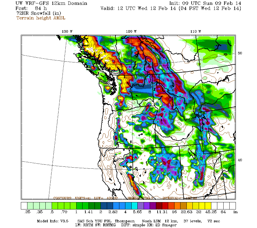
Update #2: 48 hours after initial post, models are predicting an additional 4-6 ft of snow (or more) over the next week for Washington and Oregon!
Another day later, and 2 more subsequent runs of the UW WRF-GFS model at 12-hour intervals continue to predict large snowfall amounts. The predicted amounts for both precip and snowfall have actually increased significantly for Washington and Oregon during the second major part of the storm cycle over the 6 days from Monday through Saturday, February 15. Unfortunately, the one area where model predictions for snowfall have decreased significantly is in northernmost California, specifically the Trinity Alps and California Cascades including Mount Shasta and Lassen Peak, where total snowfall amounts are likely to be only 2-3 ft instead of 4-6 ft (perhaps Lassen still might come close to 4 ft). This long-suffering region has by far the least snowpack so far this winter as a percentage of normal of any mountain region in North America (generally 0-5% of normal as of February 1, at most 10% of normal at any site), and they can't seem to catch a break this time either.
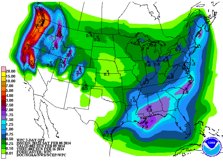
The NWS's GFS model and their Quantitative Precipitation Forecasts are now showing up to 6-10" of precip over the next week for the mountains of Oregon and Washington, with an additional 3-7" yet to come for northern California mostly over the next 2 days. Here is total precipitation in inches predicted over the next 7 days through the afternoon of Saturday, February 15:
As of Saturday morning, February 8, another 8-20" of new snow has fallen over the previous 24 hours throughout the Oregon Cascades, California Cascades, and west slopes of the Sierra Nevada as far south as Mammoth Mountain, with lesser amounts of 4-6" into Washington as far north as Mount Rainier. The largest amounts over 1 ft were in Oregon from roughly Santiam Pass through the Three Sisters south to Willamette Pass, topped by 21" new at Mount Bachelor as of 9am with continued heavy snowfall bringing the 24-hour total there to 27" by early afternoon and the snowdepth at mid-mountain (7300 ft) to 105", exceeding that at Paradise and all other NWAC or SNOTEL telemetry sites along the West Coast. Storm totals since early on February 6 now range from about 1-3 ft at most mountain sites from Mount Rainier all the way south to Mammoth Mountain, a span of over 650 miles as the crow flies.
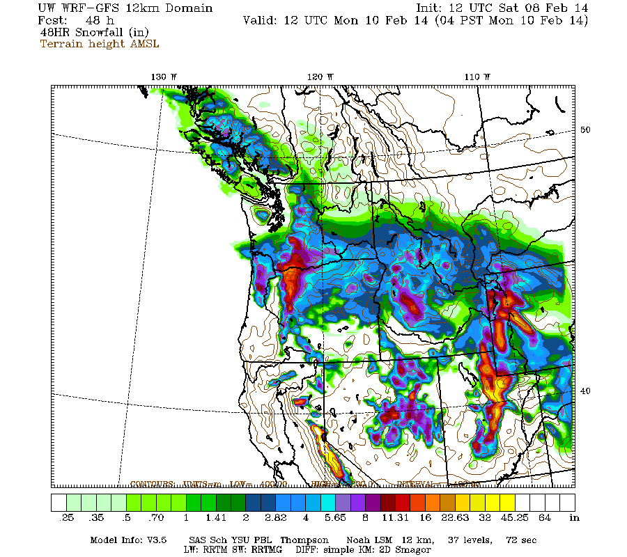
Very heavy precipitation and snowfall will continue through Sunday for northern California and to a lesser degree southern Oregon, with snow levels of 6000 ft in southern Oregon and northernmost California, and 8000 ft farther south near Lake Tahoe. Heavy snowfall will also continue in the northern Oregon and southern Washington Cascades overnight and on Sunday, along the boundary between the eroding Arctic air mass and much warmer air to the south. Additional snowfall during the next 2 days through 4am Monday is predicted to be 2-5 ft over the high Sierra Nevada, with 2-3 ft on Lassen Peak and 1-2 ft over the Oregon and southern Washington Cascades:
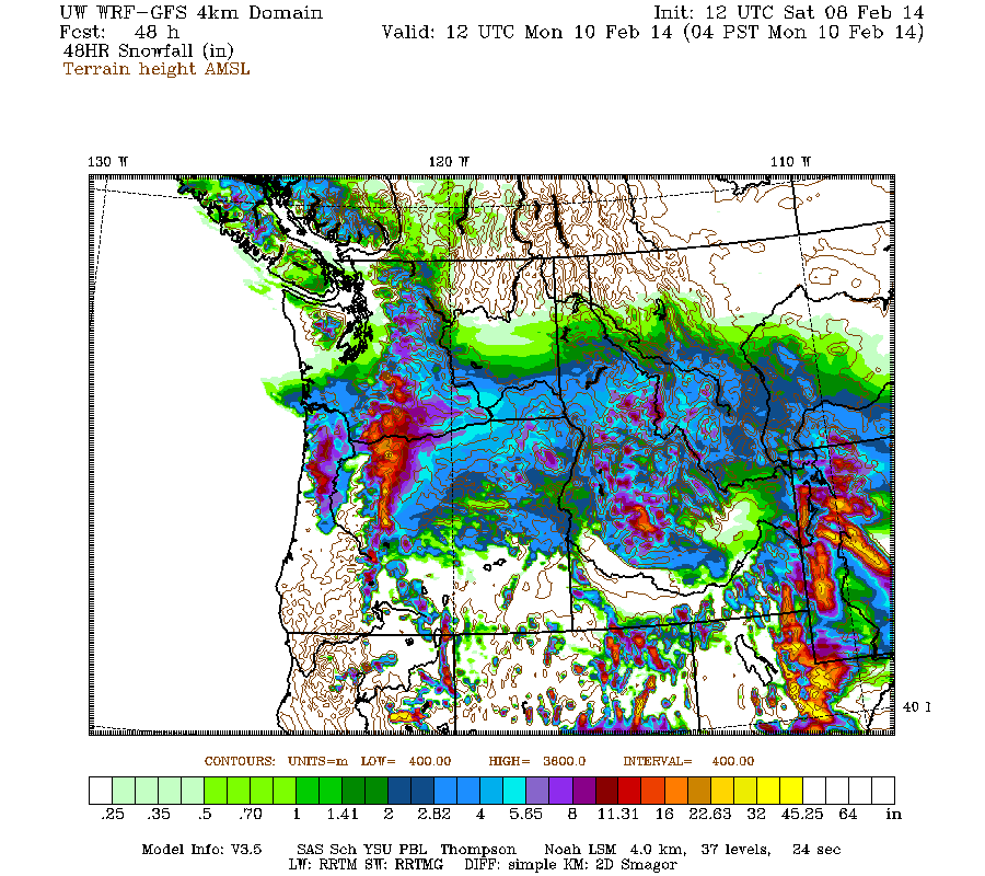
Higher resolution version of that, showing the Pacific Northwest:
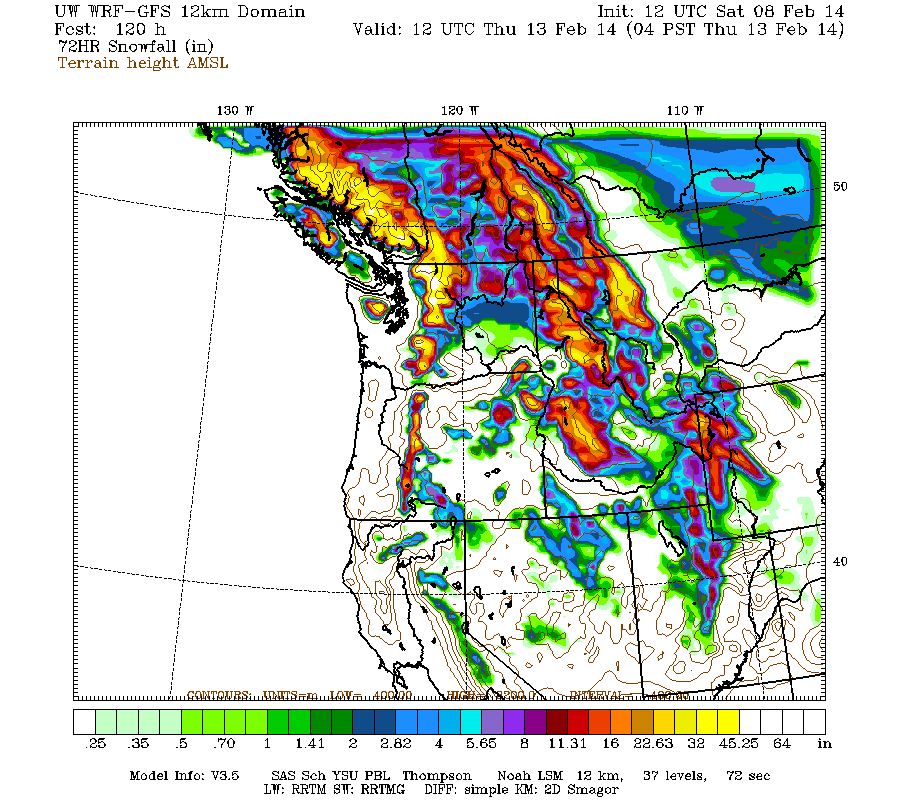
There is still a minor lull between systems predicted for late Sunday, then the next system in the cycle is expected to move ashore into Monday, this time aiming farther north towards northern Oregon, Washington, and southwestern British Columbia. The next much stronger system comes ashore in the same region Monday night into Tuesday, evolving into another atmospheric river event by Tuesday afternoon, aimed a few hundred miles farther north than the first. Snowfall during the 2-5 day period, the 3 days ending 4am next Thursday, is predicted to be 3-6 ft over the west slopes and volcanic peaks of the Washington and northern Oregon Cascades, the Olympics, and southwestern BC.
This loop shows how the model predictions for snowfall during the 3-day period through 4am Thursday have evolved between 6 subsequent runs over the last 3 days, known in the jargon as D(model)/D(t). Very consistent in the overall picture throughout, with snowfall amounts for WA increasing over the most recent runs during the past 2 days:
www.atmos.washington.edu/~ovens/wxloop.c...2+v2014021312///+-st
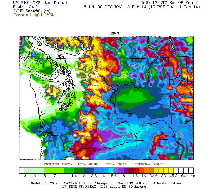
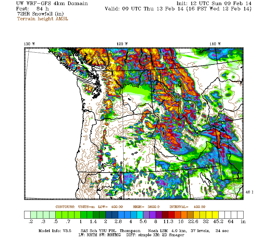
This is a higher resolution version zoomed in on Washington, covering a 3 day period which overlaps parts of the previous two graphics, ending 4pm Tuesday. Sorry about the confusing overlap of time periods, but it's temporarily unavoidable given the UW model's running cycle at 4km resolution and the timing of incoming storm systems -- however, this graphic is simply too good to omit! Maximum snowfall amounts of 4-6 ft (marked by white inside yellow) are shown throughout the west slopes and volcanic peaks of the Olympics and Washington Cascades, plus Mount Hood:
Beyond that point, the model still predicts that this storm cycle is likely to continue to bring additional systems ashore every 1-2 days, producing continued precip and heavy snowfall through next week. There may be another partial lull on Wednesday, then the next system may arrive on Thursday. Additional snowfall during the 2 day period ending 4am next Saturday is predicted to be 2-3 ft over the west slopes and volcanic peaks of the Washington and Oregon Cascades plus southwestern BC.
Details may certainly change as that period draws closer, as it is still 5-7 days out, near the limit of accurate numerical weather prediction.
Another day later, and 2 more subsequent runs of the UW WRF-GFS model at 12-hour intervals continue to predict large snowfall amounts. The predicted amounts for both precip and snowfall have actually increased significantly for Washington and Oregon during the second major part of the storm cycle over the 6 days from Monday through Saturday, February 15. Unfortunately, the one area where model predictions for snowfall have decreased significantly is in northernmost California, specifically the Trinity Alps and California Cascades including Mount Shasta and Lassen Peak, where total snowfall amounts are likely to be only 2-3 ft instead of 4-6 ft (perhaps Lassen still might come close to 4 ft). This long-suffering region has by far the least snowpack so far this winter as a percentage of normal of any mountain region in North America (generally 0-5% of normal as of February 1, at most 10% of normal at any site), and they can't seem to catch a break this time either.
The NWS's GFS model and their Quantitative Precipitation Forecasts are now showing up to 6-10" of precip over the next week for the mountains of Oregon and Washington, with an additional 3-7" yet to come for northern California mostly over the next 2 days. Here is total precipitation in inches predicted over the next 7 days through the afternoon of Saturday, February 15:
As of Saturday morning, February 8, another 8-20" of new snow has fallen over the previous 24 hours throughout the Oregon Cascades, California Cascades, and west slopes of the Sierra Nevada as far south as Mammoth Mountain, with lesser amounts of 4-6" into Washington as far north as Mount Rainier. The largest amounts over 1 ft were in Oregon from roughly Santiam Pass through the Three Sisters south to Willamette Pass, topped by 21" new at Mount Bachelor as of 9am with continued heavy snowfall bringing the 24-hour total there to 27" by early afternoon and the snowdepth at mid-mountain (7300 ft) to 105", exceeding that at Paradise and all other NWAC or SNOTEL telemetry sites along the West Coast. Storm totals since early on February 6 now range from about 1-3 ft at most mountain sites from Mount Rainier all the way south to Mammoth Mountain, a span of over 650 miles as the crow flies.
Very heavy precipitation and snowfall will continue through Sunday for northern California and to a lesser degree southern Oregon, with snow levels of 6000 ft in southern Oregon and northernmost California, and 8000 ft farther south near Lake Tahoe. Heavy snowfall will also continue in the northern Oregon and southern Washington Cascades overnight and on Sunday, along the boundary between the eroding Arctic air mass and much warmer air to the south. Additional snowfall during the next 2 days through 4am Monday is predicted to be 2-5 ft over the high Sierra Nevada, with 2-3 ft on Lassen Peak and 1-2 ft over the Oregon and southern Washington Cascades:
Higher resolution version of that, showing the Pacific Northwest:
There is still a minor lull between systems predicted for late Sunday, then the next system in the cycle is expected to move ashore into Monday, this time aiming farther north towards northern Oregon, Washington, and southwestern British Columbia. The next much stronger system comes ashore in the same region Monday night into Tuesday, evolving into another atmospheric river event by Tuesday afternoon, aimed a few hundred miles farther north than the first. Snowfall during the 2-5 day period, the 3 days ending 4am next Thursday, is predicted to be 3-6 ft over the west slopes and volcanic peaks of the Washington and northern Oregon Cascades, the Olympics, and southwestern BC.
This loop shows how the model predictions for snowfall during the 3-day period through 4am Thursday have evolved between 6 subsequent runs over the last 3 days, known in the jargon as D(model)/D(t). Very consistent in the overall picture throughout, with snowfall amounts for WA increasing over the most recent runs during the past 2 days:
www.atmos.washington.edu/~ovens/wxloop.c...2+v2014021312///+-st
This is a higher resolution version zoomed in on Washington, covering a 3 day period which overlaps parts of the previous two graphics, ending 4pm Tuesday. Sorry about the confusing overlap of time periods, but it's temporarily unavoidable given the UW model's running cycle at 4km resolution and the timing of incoming storm systems -- however, this graphic is simply too good to omit! Maximum snowfall amounts of 4-6 ft (marked by white inside yellow) are shown throughout the west slopes and volcanic peaks of the Olympics and Washington Cascades, plus Mount Hood:
Beyond that point, the model still predicts that this storm cycle is likely to continue to bring additional systems ashore every 1-2 days, producing continued precip and heavy snowfall through next week. There may be another partial lull on Wednesday, then the next system may arrive on Thursday. Additional snowfall during the 2 day period ending 4am next Saturday is predicted to be 2-3 ft over the west slopes and volcanic peaks of the Washington and Oregon Cascades plus southwestern BC.
Details may certainly change as that period draws closer, as it is still 5-7 days out, near the limit of accurate numerical weather prediction.
Please Log in or Create an account to join the conversation.
- Amar Andalkar
-
Topic Author
- User
-
Less
More
- Posts: 635
- Thank you received: 0
12 years 4 months ago - 12 years 4 months ago #220221
by Amar Andalkar
Replied by Amar Andalkar on topic Re: Next major storm brings 4-6 ft snow Feb 6-14,2014!
Update #3: 72 hours after initial post, models are still predicting an additional 4-6 ft of snow (or more) over the next week for Washington and Oregon!
Another day later, and 2 more subsequent runs of the UW WRF-GFS model at 12-hour intervals continue to predict large snowfall amounts over the next week, in addition to 1-5 ft of snow which has already fallen over the past 3 days at most mountain sites from Mount Rainier all the way south to Mammoth Mountain, a span of over 650 miles as the crow flies. The predicted amounts for both precip and snowfall remain similar to those predicted 24 hours ago. Note that there is some sort of error with the UW model's 12 km and 36 km domains (which extend out to 180 hours) since partway through Saturday evening's run and including the entire Sunday morning run, so predictions and graphics from those runs are not available at this time.
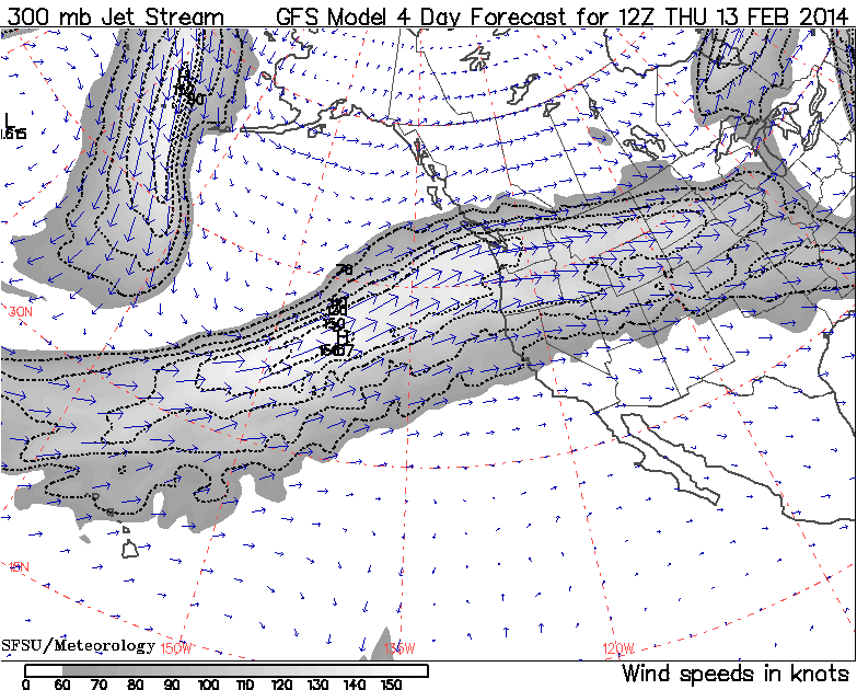
The first stage of this storm cycle, aimed primarily at the Sierra Nevada (an atmospheric river) and also at Oregon and southern Washington (frontal snowfall along the boundary between a modified Arctic air mass and warmer air to the south), is nearing completion on Sunday. The next stage will begin by Monday morning and extend throughout the next week, featuring a series of fronts and systems every 1-2 days in strong westerly flow over the north Pacific, aimed primarily at northern Oregon, Washington, and southwestern British Columbia. The fire hose of the jet stream (see Days 1-5 Jet Stream Analysis & Forecasts ) will be aimed directly into the Pacific Northwest all week, perhaps peaking in intensity at well over 160 knots (over 190 mph) on Thursday, February 13 -- it's been a LONG time since the jet stream looked anything like this, although this is often a typical look during normal wintertime:
The NWS's GFS model and their Quantitative Precipitation Forecasts are now showing up to 8-11" of precip over the next week for the mountains of Oregon and Washington, with an additional 1-3" yet to come for northern California mostly over the next day. Here is total precipitation in inches predicted over the next 7 days through the morning of Sunday, February 16:

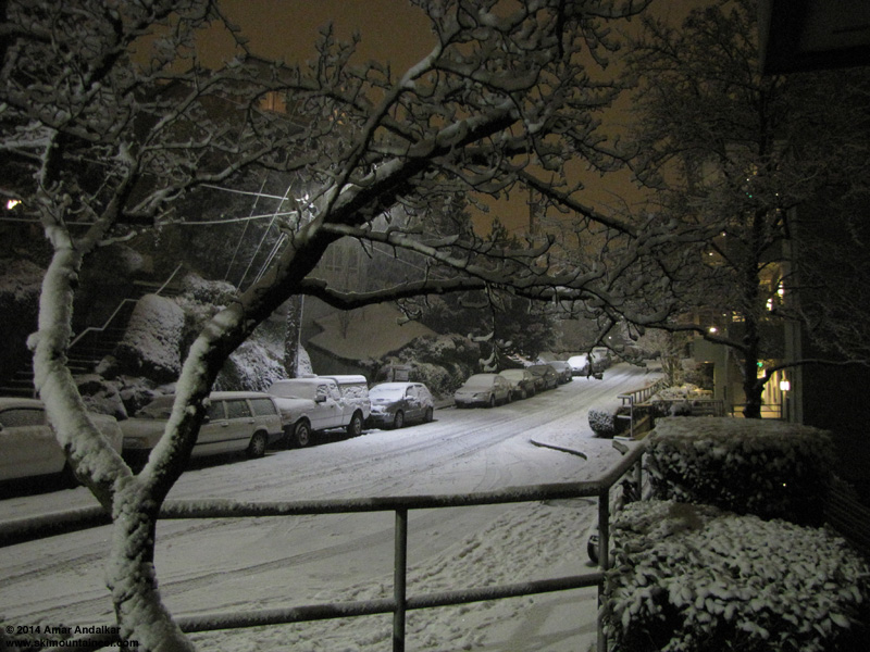
As of Sunday morning, February 9, another 6-15" of new snow has fallen over the previous 24 hours throughout the northern Oregon and southern Washington Cascades from Mount Bachelor north to Mount Rainier, with a few inches as far north as Stevens Pass and also in the southern Oregon Cascades. Note that snowfall in the North Cascades north of Stevens Pass and in southwest BC has been near-zero thus far during this storm cycle, with an Arctic air mass in place keeping skies mostly clear and temperatures well below normal -- although that is already changing quickly as of Sunday afternoon, with a few inches of new snow falling at Mount Baker. There was substantial lowland snow from the Columbia Gorge north to the Seattle-Everett area too during Saturday afternoon and evening, with 3-6" in much of southwest Washington. It was quite a surprise snowstorm for Seattle, as no forecasts had predicted any accumulating snow that far north -- but 2" accumulated on my deck at 100 ft above sea level in Seattle from 6-11pm on Saturday evening, with similar amounts for most of the city.

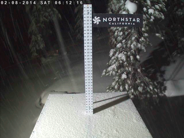
But the real jackpot for snowfall was in California as expected, with 1-3 ft falling in a 24-hour period from Lassen Peak south to Mammoth Mountain, with the highest amounts near Lake Tahoe at elevations above 7000 ft, where most of the ski areas were reporting 30-40" new at their upper stations with much lower amounts at their bases. Freakish snow differentials between lower and upper stations included 2-32" at Northstar's 6800 ft mid-mountain and 8600 ft summit, and 0.5-38" at Squaw Valley's 6200 ft base and 8200 ft upper basin, with Squaw closed for the day due to excessive heavy wet snow and avalanche hazard (as was Kirkwood). Storm totals at most of those ski area upper stations are now 4-5 ft, with perhaps 1-2 ft more possible by Monday morning.
Here is a humorous sequence of images captured by the Northstar Snow Stake Cam at 8300 ft over the past 36 hours, showing the snowfall accumulating to almost 30" deep in 24 hours just before the automated flipping mechanism attempts to clear the stake at 5:40am Sunday -- but the 180° flip fails to complete, and the snow stake sits helplessly ajar until mid-afternoon, when someone finally fixes it:
There is currently a partial lull between systems for the rest of Sunday, then the next system in the cycle will move ashore overnight into Monday, this time aiming farther north towards northern Oregon, Washington, and southwestern British Columbia. The next much stronger system comes ashore in the same region on Tuesday, evolving into another atmospheric river event aimed a few hundred miles farther north than the first.
Additional snowfall during the next 3 days through 4am Wednesday is predicted to be 3-6 ft over the west slopes and volcanic peaks of the Washington and northern Oregon Cascades, the Olympics, and southwestern BC, with 1-2 ft over the Sierra Nevada (all of that by Monday). Note that the first 12 km graphic here is taken from Saturday evening's partially completed 12 km model run:
Higher resolution version of that (from the current Sunday morning model run, through 4pm Wednesday), showing the Pacific Northwest and also zoomed in on Washington and Oregon:
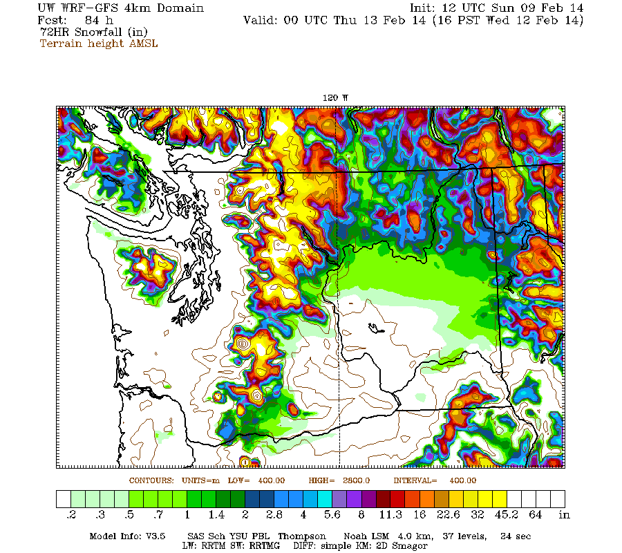
Maximum snowfall amounts of 4-6 ft (marked by white inside yellow) are shown throughout the west slopes and volcanic peaks of the Olympics and Washington Cascades, parts of southwest BC, plus Mounts Hood, Jefferson, and the Three Sisters in Oregon.
Graphics beyond 84 hours are not available at this time due to the UW model run issues mentioned above.
Another day later, and 2 more subsequent runs of the UW WRF-GFS model at 12-hour intervals continue to predict large snowfall amounts over the next week, in addition to 1-5 ft of snow which has already fallen over the past 3 days at most mountain sites from Mount Rainier all the way south to Mammoth Mountain, a span of over 650 miles as the crow flies. The predicted amounts for both precip and snowfall remain similar to those predicted 24 hours ago. Note that there is some sort of error with the UW model's 12 km and 36 km domains (which extend out to 180 hours) since partway through Saturday evening's run and including the entire Sunday morning run, so predictions and graphics from those runs are not available at this time.
The first stage of this storm cycle, aimed primarily at the Sierra Nevada (an atmospheric river) and also at Oregon and southern Washington (frontal snowfall along the boundary between a modified Arctic air mass and warmer air to the south), is nearing completion on Sunday. The next stage will begin by Monday morning and extend throughout the next week, featuring a series of fronts and systems every 1-2 days in strong westerly flow over the north Pacific, aimed primarily at northern Oregon, Washington, and southwestern British Columbia. The fire hose of the jet stream (see Days 1-5 Jet Stream Analysis & Forecasts ) will be aimed directly into the Pacific Northwest all week, perhaps peaking in intensity at well over 160 knots (over 190 mph) on Thursday, February 13 -- it's been a LONG time since the jet stream looked anything like this, although this is often a typical look during normal wintertime:
The NWS's GFS model and their Quantitative Precipitation Forecasts are now showing up to 8-11" of precip over the next week for the mountains of Oregon and Washington, with an additional 1-3" yet to come for northern California mostly over the next day. Here is total precipitation in inches predicted over the next 7 days through the morning of Sunday, February 16:
As of Sunday morning, February 9, another 6-15" of new snow has fallen over the previous 24 hours throughout the northern Oregon and southern Washington Cascades from Mount Bachelor north to Mount Rainier, with a few inches as far north as Stevens Pass and also in the southern Oregon Cascades. Note that snowfall in the North Cascades north of Stevens Pass and in southwest BC has been near-zero thus far during this storm cycle, with an Arctic air mass in place keeping skies mostly clear and temperatures well below normal -- although that is already changing quickly as of Sunday afternoon, with a few inches of new snow falling at Mount Baker. There was substantial lowland snow from the Columbia Gorge north to the Seattle-Everett area too during Saturday afternoon and evening, with 3-6" in much of southwest Washington. It was quite a surprise snowstorm for Seattle, as no forecasts had predicted any accumulating snow that far north -- but 2" accumulated on my deck at 100 ft above sea level in Seattle from 6-11pm on Saturday evening, with similar amounts for most of the city.
But the real jackpot for snowfall was in California as expected, with 1-3 ft falling in a 24-hour period from Lassen Peak south to Mammoth Mountain, with the highest amounts near Lake Tahoe at elevations above 7000 ft, where most of the ski areas were reporting 30-40" new at their upper stations with much lower amounts at their bases. Freakish snow differentials between lower and upper stations included 2-32" at Northstar's 6800 ft mid-mountain and 8600 ft summit, and 0.5-38" at Squaw Valley's 6200 ft base and 8200 ft upper basin, with Squaw closed for the day due to excessive heavy wet snow and avalanche hazard (as was Kirkwood). Storm totals at most of those ski area upper stations are now 4-5 ft, with perhaps 1-2 ft more possible by Monday morning.
Here is a humorous sequence of images captured by the Northstar Snow Stake Cam at 8300 ft over the past 36 hours, showing the snowfall accumulating to almost 30" deep in 24 hours just before the automated flipping mechanism attempts to clear the stake at 5:40am Sunday -- but the 180° flip fails to complete, and the snow stake sits helplessly ajar until mid-afternoon, when someone finally fixes it:
There is currently a partial lull between systems for the rest of Sunday, then the next system in the cycle will move ashore overnight into Monday, this time aiming farther north towards northern Oregon, Washington, and southwestern British Columbia. The next much stronger system comes ashore in the same region on Tuesday, evolving into another atmospheric river event aimed a few hundred miles farther north than the first.
Additional snowfall during the next 3 days through 4am Wednesday is predicted to be 3-6 ft over the west slopes and volcanic peaks of the Washington and northern Oregon Cascades, the Olympics, and southwestern BC, with 1-2 ft over the Sierra Nevada (all of that by Monday). Note that the first 12 km graphic here is taken from Saturday evening's partially completed 12 km model run:
Higher resolution version of that (from the current Sunday morning model run, through 4pm Wednesday), showing the Pacific Northwest and also zoomed in on Washington and Oregon:
Maximum snowfall amounts of 4-6 ft (marked by white inside yellow) are shown throughout the west slopes and volcanic peaks of the Olympics and Washington Cascades, parts of southwest BC, plus Mounts Hood, Jefferson, and the Three Sisters in Oregon.
Graphics beyond 84 hours are not available at this time due to the UW model run issues mentioned above.
Please Log in or Create an account to join the conversation.
- filbo
-
- User
-
Less
More
- Posts: 184
- Thank you received: 0
12 years 4 months ago #220223
by filbo
Replied by filbo on topic Re: Next major storm brings 4-6 ft snow Feb 6-14,2014!
An unusual aspect reared its head this morning at white pass which is about 20 miles south east of Mt Rainier as the crow flies and that was a wierd inversion which produced a rain crust on all of the fresh overnite snow above 5000 ft and kept the powder skiable below. A bit of a drag but sometimes that is the deal in the pnw.
Please Log in or Create an account to join the conversation.
- Andrew Carey
-

- User
-
Less
More
- Posts: 914
- Thank you received: 0
12 years 4 months ago #220236
by Andrew Carey
Yes.
Replied by Andrew Carey on topic Re: Next major storm brings 4-6 ft snow Feb 6-14,2014!
An unusual aspect reared its head this morning at white pass which is about 20 miles south east of Mt Rainier as the crow flies and that was a wierd inversion which produced a rain crust on all of the fresh overnite snow above 5000 ft and kept the powder skiable below. A bit of a drag but sometimes that is the deal in the pnw.
Yes.
Please Log in or Create an account to join the conversation.
- Amar Andalkar
-
Topic Author
- User
-
Less
More
- Posts: 635
- Thank you received: 0
12 years 4 months ago - 12 years 4 months ago #220257
by Amar Andalkar
Replied by Amar Andalkar on topic Re: Next major storm brings 4-6 ft snow Feb 6-14,2014!
Update #4: 96 hours after initial post, an additional 4-8 ft of snow (or more) is predicted over the next week for Washington and Oregon!
Another day later, and 2 more subsequent runs of the UW WRF-GFS model at 12-hour intervals continue to predict large snowfall amounts of 4-8 ft (and perhaps much more) over the next week for Washington and Oregon, in addition to 2-6 ft of snow which has already fallen over the past 4 days at most mountain sites from Mount Rainier all the way south to Mammoth Mountain, a span of over 650 miles as the crow flies. The predicted amounts for both precip and snowfall over the next week remain similar to those predicted 24 and 48 hours ago, a good sign of stability in the model's predictions, with a slight increase in overall totals as further storm systems come into view. (Note that the problem with the UW model's 12 km and 36 km domains has been fixed as of Monday morning, and the missing model runs since Sunday morning have been run retroactively.)
The first stage of this storm cycle, aimed primarily at the Sierra Nevada (an atmospheric river) and also at Oregon and southern Washington (frontal snowfall along the boundary between a modified Arctic air mass and warmer air to the south), is pretty much over as of Monday. The next stage has already begun early Monday morning and will extend throughout this week, featuring a series of fronts and systems every 1-2 days in strong westerly and southwesterly flow over the north Pacific, aimed primarily at northern Oregon, Washington, and southwestern British Columbia.
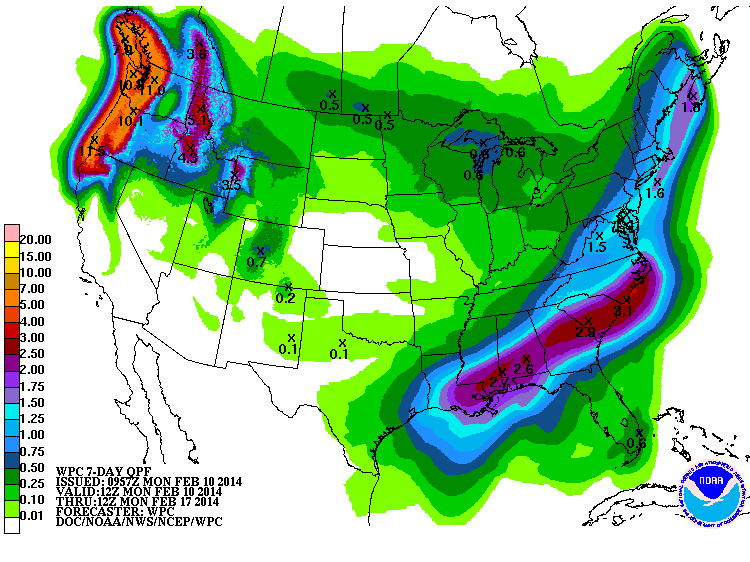
The NWS's GFS model and their Quantitative Precipitation Forecasts continue to show up to 8-11" of precip over the next week for the mountains of southwestern BC, Washington, Oregon, and northwestern California, with much smaller amounts of only a fraction of an inch farther south in the Sierra. Here is total precipitation in inches predicted over the next 7 days through the morning of Monday, February 17:
As of Monday morning, February 10, another 4-6" of new snow has fallen over the previous 24 hours throughout the Washington Cascades and in southernmost BC on the North Shore of Vancouver, with much lesser amounts of 1-2" farther south in the Oregon Cascades as freezing levels rose sharply on Sunday morning to 6000 ft or higher with cold air still trapped at lower elevations, producing rain crusts and freezing rain in some areas like Mount Hood and White Pass. Additional snowfall during the day Monday has already produced another 4-8" of new snow since this morning (as of 2pm) at many sites in the Washington Cascades, even on the east side of the range, with the snow level varying from 2000-5000 ft north to south (and depending on easterly pass flow), while the northern Oregon Cascades have again gotten a mix of precip with barely 1-2" of new snow and snow levels still near 6000 ft.
Once again the jackpot for 24-hour snowfall as of Monday morning was in California, with another 0.5-2 ft falling from Lassen Peak south to Mammoth Mountain, with the highest amounts near Lake Tahoe at elevations above 7000 ft, where most of the ski areas were reporting 12-24" new at their upper stations with much lower amounts of only a few inches at their bases just like the previous day. Final storm totals at many ski area upper stations near Lake Tahoe above 8000 ft are now 5-7 ft, with more like 1-2 ft total at the 6000 ft level. Areas farther south such as Yosemite and Mammoth received much less snowfall, only about 2-3 ft even at 9000 ft, and only 2" total at 9000 ft on June Mountain located just north of Mammoth in the rain shadow of the Sierra Crest. Little additional snowfall is currently expected over the next week for any part of the Sierra Nevada.
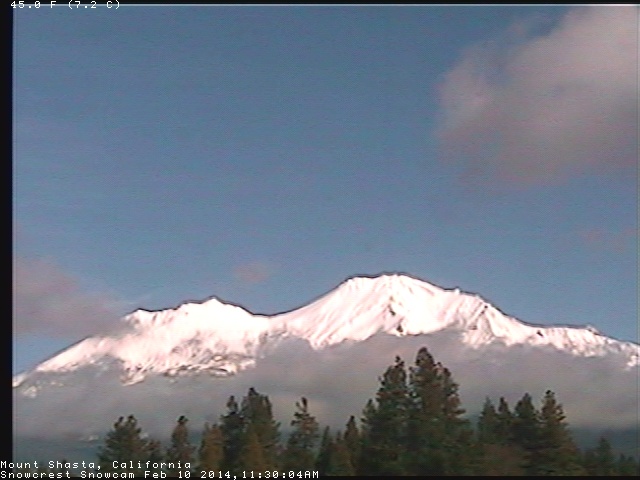
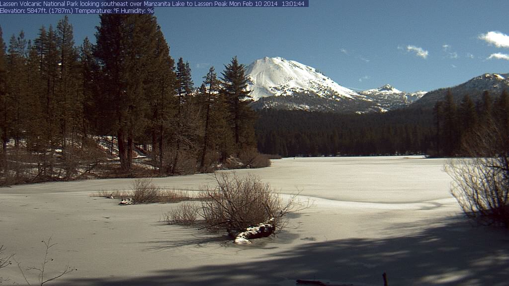
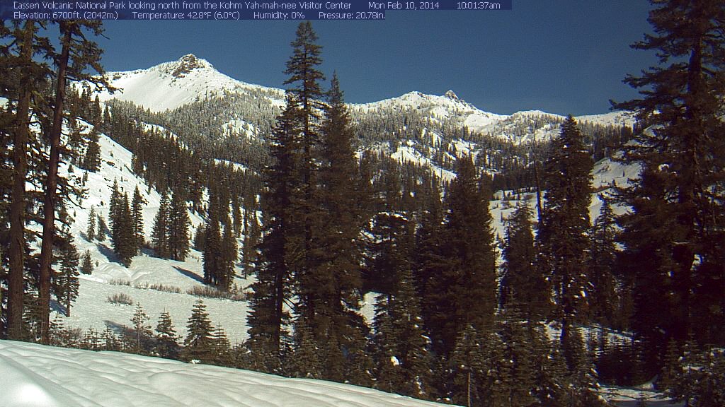
In the Cascade Range, snow totals thus far since the storm cycle began early on February 6 range from a few inches in the North Cascades and Mount Baker, to about 1 ft at Stevens and Snoqualmie Passes, 1.5 ft at Mount Rainier Paradise, 2.5 ft at White Pass and Mount Hood, 3.5 ft on Mount Bachelor, 2 ft at Willamette Pass and Crater Lake, and 1.5-2 ft on Mount Shasta. Snowfall totals on Lassen Peak are unknown due to a long-term outage at the 8250 ft Lake Helen telemetry site, but are probably about 3-4 ft at that elevation given about 2 ft near the park's southwest entrance at 6700 ft. It's nice to see Shasta and Lassen looking snowy and white once again today as they should be, since both were still almost entirely bare as of 2 weeks ago and had only a thin skift of snow prior to this storm cycle:
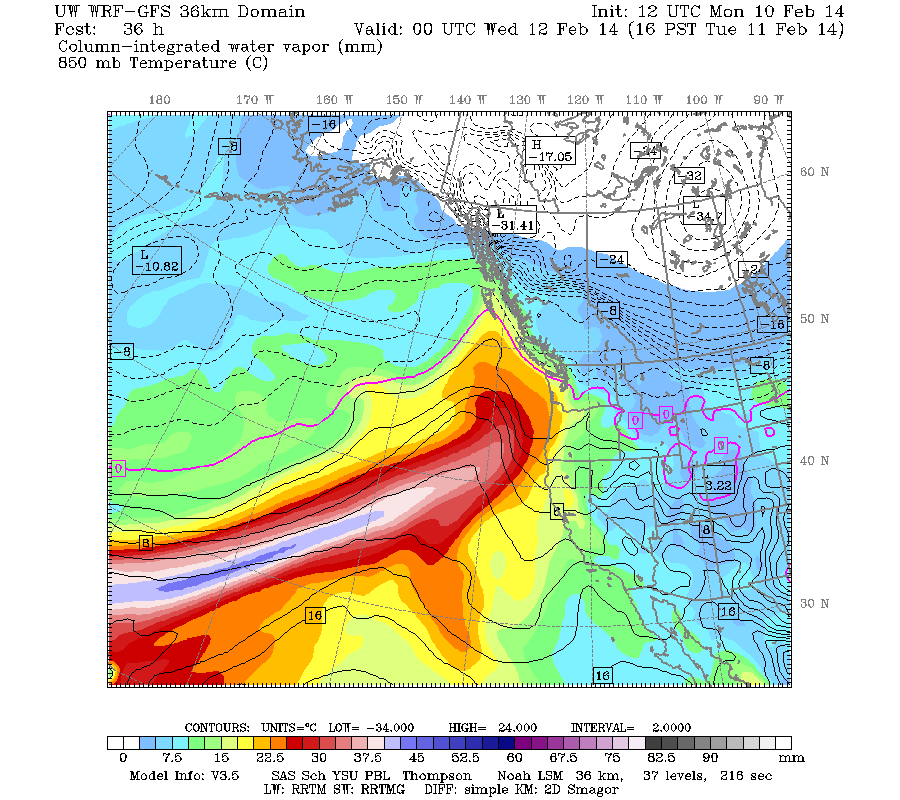
The first system of the second phase of this cycle has already come ashore Monday morning, this time aimed farther north towards northern Oregon, Washington, and southwestern British Columbia. The next much stronger system comes ashore in the same region on Tuesday afternoon, evolving into another atmospheric river event aimed a few hundred miles farther north than the first. This image shows the predicted plume of moisture streaming out of the subtropics near Hawaii towards Oregon as of Tuesday afternoon, which looks very similar to the same image in Update #1 above generated 3 days earlier, another good sign of stability in the model's predictions:
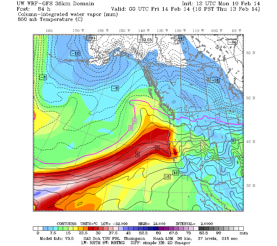
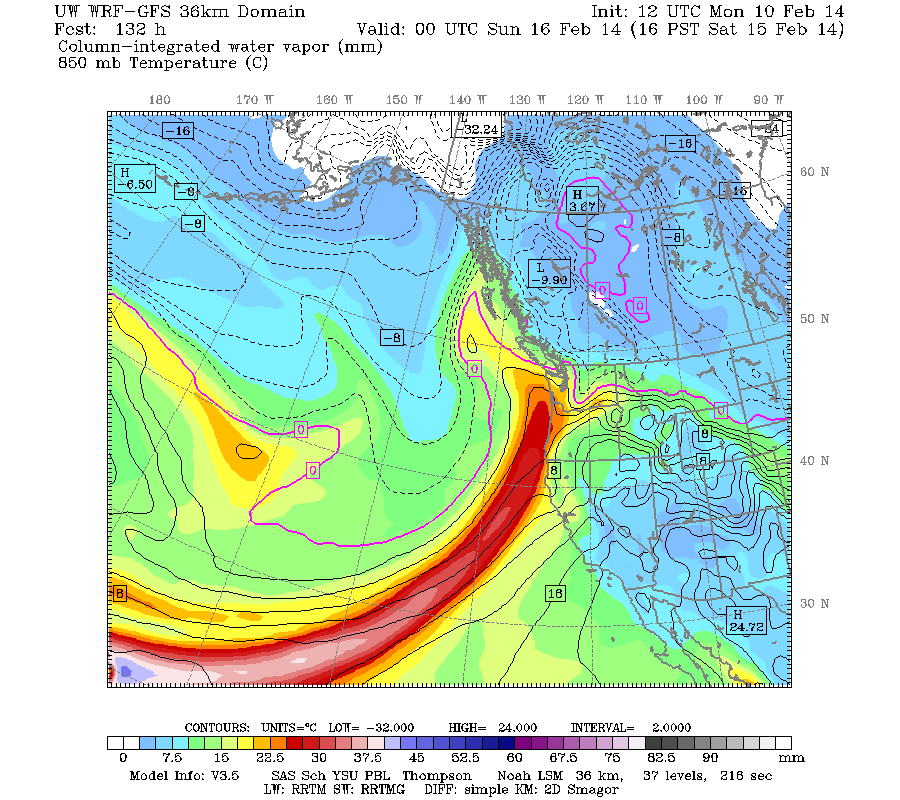
This atmospheric river is expected to stay in place for the next 3-4 days, weakening only slightly by Thursday afternoon and more significantly by Saturday afternoon before it finally fades away:
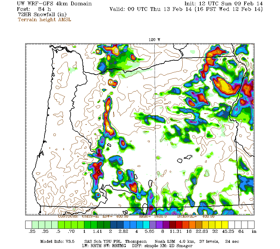
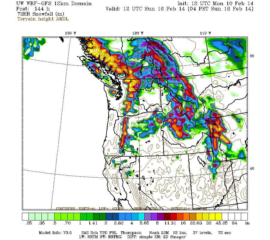
Snowfall during the next 3 days through 4am Thursday is predicted to be 3-6 ft over the west slopes and volcanic peaks of the Washington and northern Oregon Cascades, the Olympics, and southwestern BC:
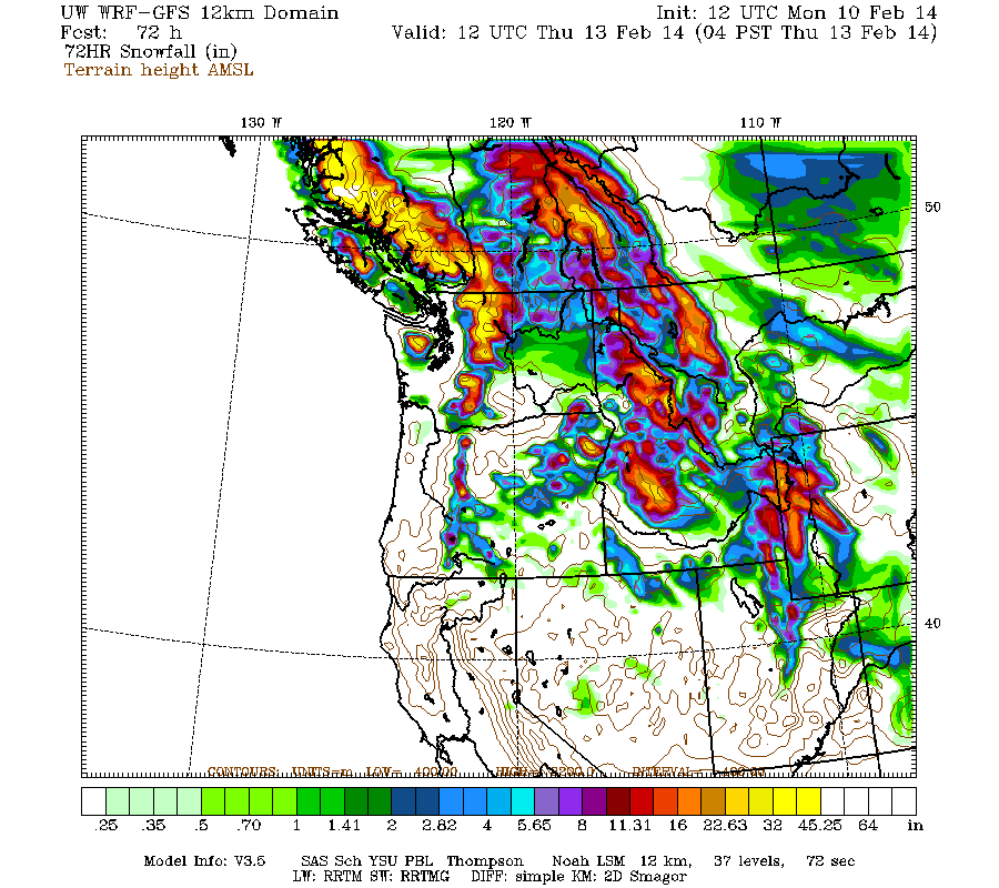
Higher resolution version of that, showing the Pacific Northwest and also zoomed in on Washington and Oregon:
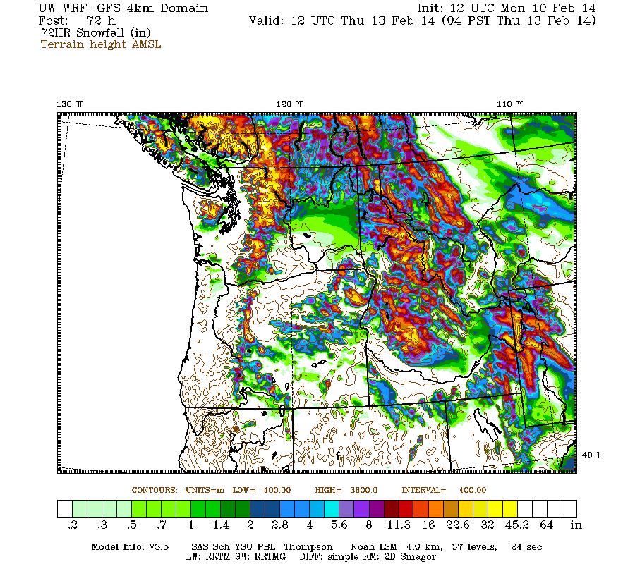
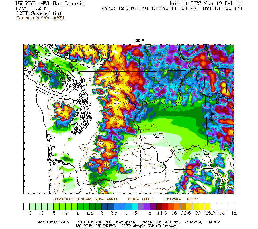
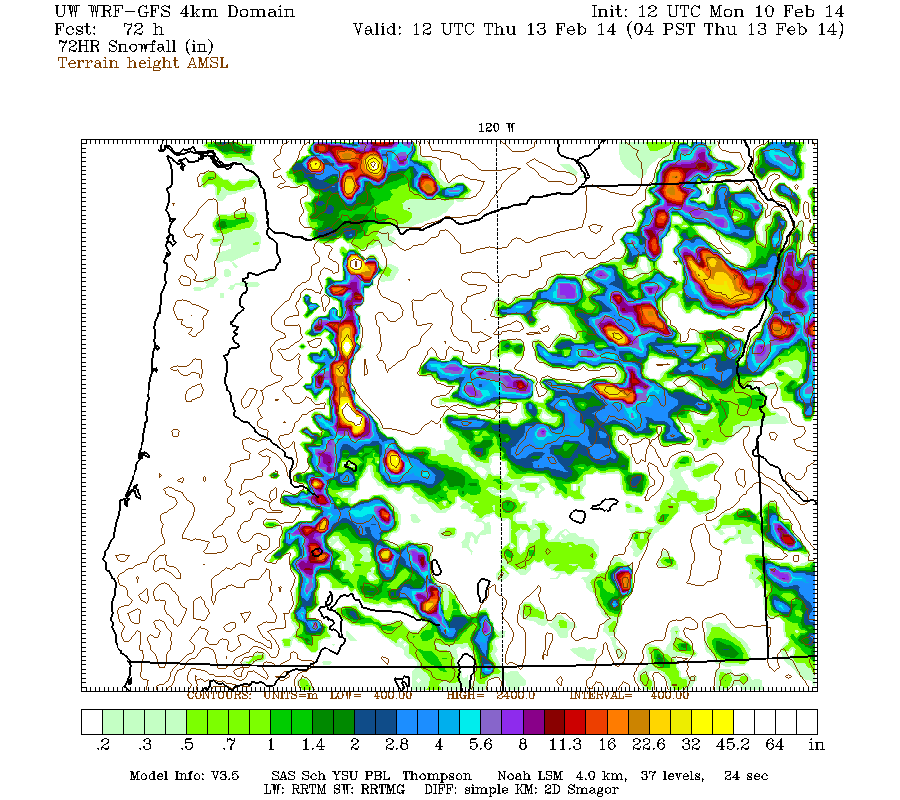
Maximum snowfall amounts of 4-6 ft (marked by white inside yellow) are shown throughout the west slopes and volcanic peaks of the Olympics and Washington Cascades, parts of southwest BC, plus Mounts Hood, Jefferson, and the Three Sisters in Oregon.
This loop shows how the model predictions for snowfall during the 3-day period through 4am Thursday have evolved between 9 subsequent runs (1 missing) over the last 5 days, known in the jargon as D(model)/D(t). Very consistent in the overall picture throughout, with snowfall amounts increasing and decreasing a bit, but no major changes except that the bit of snow predicted for the Sierra on some runs has now vanished:
www.atmos.washington.edu/~ovens/wxloop.c...2+v2014021312///+-st
Additional snowfall during the 3-6 day period, the 3 days ending 4am next Sunday, is predicted to be 2-3 ft over the west slopes and volcanic peaks of the Washington and northern Oregon Cascades, the Olympics, and southwestern BC.
If those model predictions verify, it would bring the snowpack to well above normal values at most sites above 4000-5000 ft in southwestern BC and the Washington and northern Oregon Cascades, and close to normal values in the Olympics and southern Oregon Cascades (above 6000 ft). The snowpack at low elevations (below 4000 ft in WA, 5-6000 ft in OR) may remain below normal however, as snow levels will fluctuate above those elevations at times throughout the upcoming week.
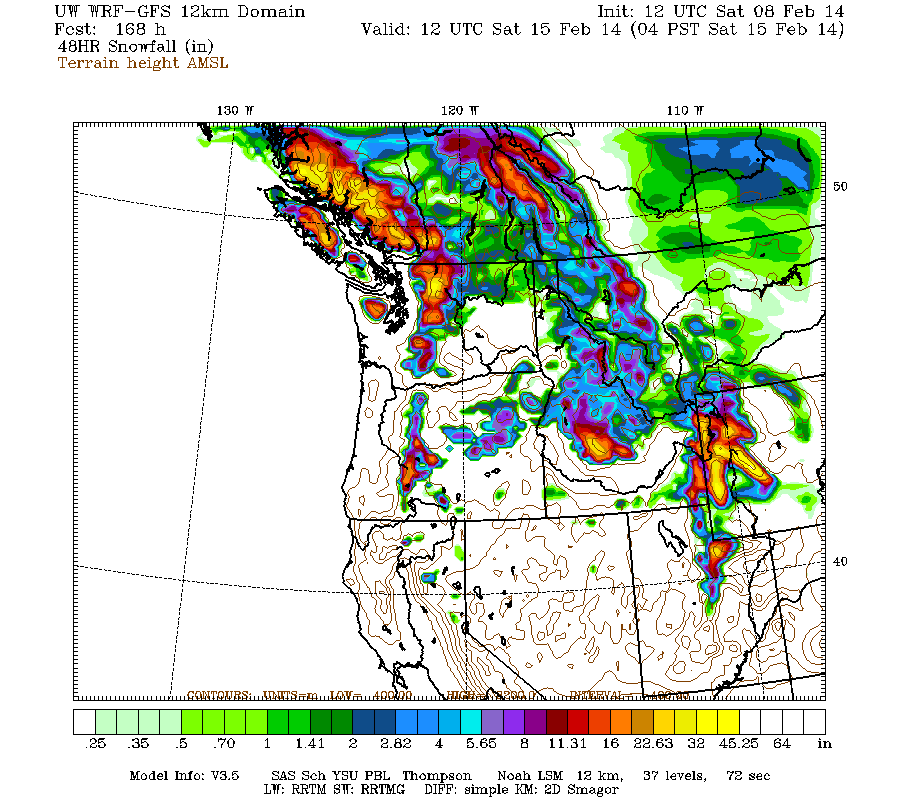
Beyond that point, it appears that this storm cycle is likely to continue to bring additional systems ashore every 1-2 days, producing continued precip and heavy snowfall through next weekend and perhaps beyond. Additional snowfall during the 2 day period ending 4pm next Monday (which overlaps the previous graphic by 12 hours) is predicted to be 2-5 ft over the west slopes and volcanic peaks of the Washington Cascades and Olympics plus southwestern BC, with about 1 ft for the Oregon Cascades.
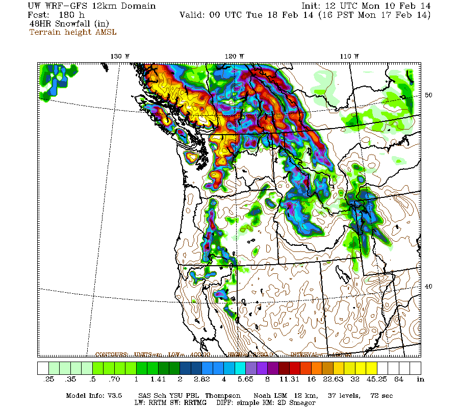
Details may certainly change as that period draws closer, as it is currently 5-7 days out, near the limit of accurate numerical weather prediction. But it puts the predicted 7.5-day snowfall totals at roughly 6-12 ft (!!) over the west slopes and volcanic peaks of the Washington Cascades, the Olympics, and southwestern BC, with about 4-8 ft in the Oregon Cascades.
Another day later, and 2 more subsequent runs of the UW WRF-GFS model at 12-hour intervals continue to predict large snowfall amounts of 4-8 ft (and perhaps much more) over the next week for Washington and Oregon, in addition to 2-6 ft of snow which has already fallen over the past 4 days at most mountain sites from Mount Rainier all the way south to Mammoth Mountain, a span of over 650 miles as the crow flies. The predicted amounts for both precip and snowfall over the next week remain similar to those predicted 24 and 48 hours ago, a good sign of stability in the model's predictions, with a slight increase in overall totals as further storm systems come into view. (Note that the problem with the UW model's 12 km and 36 km domains has been fixed as of Monday morning, and the missing model runs since Sunday morning have been run retroactively.)
The first stage of this storm cycle, aimed primarily at the Sierra Nevada (an atmospheric river) and also at Oregon and southern Washington (frontal snowfall along the boundary between a modified Arctic air mass and warmer air to the south), is pretty much over as of Monday. The next stage has already begun early Monday morning and will extend throughout this week, featuring a series of fronts and systems every 1-2 days in strong westerly and southwesterly flow over the north Pacific, aimed primarily at northern Oregon, Washington, and southwestern British Columbia.
The NWS's GFS model and their Quantitative Precipitation Forecasts continue to show up to 8-11" of precip over the next week for the mountains of southwestern BC, Washington, Oregon, and northwestern California, with much smaller amounts of only a fraction of an inch farther south in the Sierra. Here is total precipitation in inches predicted over the next 7 days through the morning of Monday, February 17:
As of Monday morning, February 10, another 4-6" of new snow has fallen over the previous 24 hours throughout the Washington Cascades and in southernmost BC on the North Shore of Vancouver, with much lesser amounts of 1-2" farther south in the Oregon Cascades as freezing levels rose sharply on Sunday morning to 6000 ft or higher with cold air still trapped at lower elevations, producing rain crusts and freezing rain in some areas like Mount Hood and White Pass. Additional snowfall during the day Monday has already produced another 4-8" of new snow since this morning (as of 2pm) at many sites in the Washington Cascades, even on the east side of the range, with the snow level varying from 2000-5000 ft north to south (and depending on easterly pass flow), while the northern Oregon Cascades have again gotten a mix of precip with barely 1-2" of new snow and snow levels still near 6000 ft.
Once again the jackpot for 24-hour snowfall as of Monday morning was in California, with another 0.5-2 ft falling from Lassen Peak south to Mammoth Mountain, with the highest amounts near Lake Tahoe at elevations above 7000 ft, where most of the ski areas were reporting 12-24" new at their upper stations with much lower amounts of only a few inches at their bases just like the previous day. Final storm totals at many ski area upper stations near Lake Tahoe above 8000 ft are now 5-7 ft, with more like 1-2 ft total at the 6000 ft level. Areas farther south such as Yosemite and Mammoth received much less snowfall, only about 2-3 ft even at 9000 ft, and only 2" total at 9000 ft on June Mountain located just north of Mammoth in the rain shadow of the Sierra Crest. Little additional snowfall is currently expected over the next week for any part of the Sierra Nevada.
In the Cascade Range, snow totals thus far since the storm cycle began early on February 6 range from a few inches in the North Cascades and Mount Baker, to about 1 ft at Stevens and Snoqualmie Passes, 1.5 ft at Mount Rainier Paradise, 2.5 ft at White Pass and Mount Hood, 3.5 ft on Mount Bachelor, 2 ft at Willamette Pass and Crater Lake, and 1.5-2 ft on Mount Shasta. Snowfall totals on Lassen Peak are unknown due to a long-term outage at the 8250 ft Lake Helen telemetry site, but are probably about 3-4 ft at that elevation given about 2 ft near the park's southwest entrance at 6700 ft. It's nice to see Shasta and Lassen looking snowy and white once again today as they should be, since both were still almost entirely bare as of 2 weeks ago and had only a thin skift of snow prior to this storm cycle:
The first system of the second phase of this cycle has already come ashore Monday morning, this time aimed farther north towards northern Oregon, Washington, and southwestern British Columbia. The next much stronger system comes ashore in the same region on Tuesday afternoon, evolving into another atmospheric river event aimed a few hundred miles farther north than the first. This image shows the predicted plume of moisture streaming out of the subtropics near Hawaii towards Oregon as of Tuesday afternoon, which looks very similar to the same image in Update #1 above generated 3 days earlier, another good sign of stability in the model's predictions:
This atmospheric river is expected to stay in place for the next 3-4 days, weakening only slightly by Thursday afternoon and more significantly by Saturday afternoon before it finally fades away:
Snowfall during the next 3 days through 4am Thursday is predicted to be 3-6 ft over the west slopes and volcanic peaks of the Washington and northern Oregon Cascades, the Olympics, and southwestern BC:
Higher resolution version of that, showing the Pacific Northwest and also zoomed in on Washington and Oregon:
Maximum snowfall amounts of 4-6 ft (marked by white inside yellow) are shown throughout the west slopes and volcanic peaks of the Olympics and Washington Cascades, parts of southwest BC, plus Mounts Hood, Jefferson, and the Three Sisters in Oregon.
This loop shows how the model predictions for snowfall during the 3-day period through 4am Thursday have evolved between 9 subsequent runs (1 missing) over the last 5 days, known in the jargon as D(model)/D(t). Very consistent in the overall picture throughout, with snowfall amounts increasing and decreasing a bit, but no major changes except that the bit of snow predicted for the Sierra on some runs has now vanished:
www.atmos.washington.edu/~ovens/wxloop.c...2+v2014021312///+-st
Additional snowfall during the 3-6 day period, the 3 days ending 4am next Sunday, is predicted to be 2-3 ft over the west slopes and volcanic peaks of the Washington and northern Oregon Cascades, the Olympics, and southwestern BC.
If those model predictions verify, it would bring the snowpack to well above normal values at most sites above 4000-5000 ft in southwestern BC and the Washington and northern Oregon Cascades, and close to normal values in the Olympics and southern Oregon Cascades (above 6000 ft). The snowpack at low elevations (below 4000 ft in WA, 5-6000 ft in OR) may remain below normal however, as snow levels will fluctuate above those elevations at times throughout the upcoming week.
Beyond that point, it appears that this storm cycle is likely to continue to bring additional systems ashore every 1-2 days, producing continued precip and heavy snowfall through next weekend and perhaps beyond. Additional snowfall during the 2 day period ending 4pm next Monday (which overlaps the previous graphic by 12 hours) is predicted to be 2-5 ft over the west slopes and volcanic peaks of the Washington Cascades and Olympics plus southwestern BC, with about 1 ft for the Oregon Cascades.
Details may certainly change as that period draws closer, as it is currently 5-7 days out, near the limit of accurate numerical weather prediction. But it puts the predicted 7.5-day snowfall totals at roughly 6-12 ft (!!) over the west slopes and volcanic peaks of the Washington Cascades, the Olympics, and southwestern BC, with about 4-8 ft in the Oregon Cascades.
Please Log in or Create an account to join the conversation.