- Posts: 184
- Thank you received: 0
HUGE storm cycle brings 4-14 ft snow Feb6-25,2014!
- filbo
-

- User
-

Less
More
12 years 4 months ago #220485
by filbo
Replied by filbo on topic Re: HUGE storm cycle brings 4-12 ft snow Feb6-21,2014!
Thanks again for your forecasts and weather research, white pass has been 100% operational over the holiday weekend even with the strong winds all the chairs stayed open . If Crystal is closed are you not allowed to hike up and ski if the lifts aren't running? It was the deepest day of the season today knee deep and plus.
Please Log in or Create an account to join the conversation.
- Amar Andalkar
-
Topic Author
- User
-
Less
More
- Posts: 635
- Thank you received: 0
12 years 4 months ago - 12 years 3 months ago #220540
by Amar Andalkar
Replied by Amar Andalkar on topic Re: HUGE storm cycle brings 4-12 ft snow Feb6-21,2014!
Table of total snowfall and precip, February 6-18, 2014:
Given the very heavy snowfall of 2-4 ft over the past 48 hours through Tuesday evening in southwestern BC, Washington, and northern Oregon, it seems like a good time to recalculate and update the snow totals during this storm cycle. This table shows the total snowfall and precip over the 12+ day period from February 6 through Tuesday evening, February 18, along with the increase in snowdepth from February 6 up to the maximum depth reached during this storm cycle thus far (most maxima occurred on February 17 or 18 at these sites, except for some low-elevation sites in Oregon and all sites in California where the maxima occurred a week earlier). Some amounts are estimated and approximate, including all snowfall totals at SNOTEL, BCRFC, and CCSS sites (they have only a total snowdepth sensor, not a 24-hour snowfall sensor like most NWAC sites).
Total snowfall amounts of 5-10 ft have been recorded at most measurement sites above 3000-7000 ft over a large swath of mountains extending from southwestern BC through the Olympics and Washington Cascades and along most of the Oregon Cascades as far south as Crater Lake. Most of these sites also received very high precipitation totals generally over 10", with maximum amounts exceeding 20" on Mount Hood and on the west flanks of the Three Sisters in Oregon -- that's about 20% of the entire average annual precipitation (which is 105" at Mount Hood Test Site SNOTEL and 97" at McKenzie SNOTEL on the NW side of the Three Sisters) in only 12 days!! The snow level rose as high as 7000 ft several times last week in that region, and storm total snowfall above 7000 ft likely exceeds 12 ft on Mount Hood and the Three Sisters already (probably Mount Jefferson too), with over 8 ft actually measured on Mount Hood at 5400-5900 ft and even Mount Bachelor at 6300 ft, despite being partially rain-shadowed several miles east of the Cascade Crest.
[tt]
Increase in
Total Snowdepth Total
Measurement Site Elevation Snowfall Feb6 >>> Max Precip Notes
========= Alaska =========
--- Chugach Mountains ----
Indian Pass SNOTEL 2350 ft 1 ft 31" >>> 39" 1" (just SE of Anchorage)
Alyeska Resort, Top Station 2750 ft 3 ft 66" >>> 84" -- (SE of Anchorage)
Alyeska Resort, Mid Station 1650 ft 2.5 ft 33" >>> 50" -- (SE of Anchorage)
Alyeska Resort, Base 250 ft 2 ft 2" >>> 27" -- (SE of Anchorage)
Mt Alyeska SNOTEL 1540 ft 1.5 ft 20" >>> 32" 2" (halfway up Alyeska Resort)
Turnagain Pass SNOTEL 1880 ft 3 ft 29" >>> 57" 3.5" (SE of Anchorage)
Grandview SNOTEL 1100 ft 3 ft 13" >>> 42" 3.5" (SE of Anchorage)
Exit Glacier SNOTEL 400 ft 2 ft 13" >>> 30" 2" (NW of Seward)
** 130 miles between these sites **
Valdez NWS Office 100 ft 0.8 ft 31" >>> 38" 0.5"
Sugarloaf Mtn SNOTEL 550 ft 1 ft 41" >>> 48" 1" (S of Valdez)
Thompson Pass 2750 ft 1.5 ft 47" >>> 54" -- (E of Valdez)
Upper Tsaina River SNOTEL 1750 ft 1.5 ft 38" >>> 51" 2" (NE of Thompson Pass)
Mt Eyak SNOTEL 1400 ft 2 ft 11" >>> 28" 2.5" (NE of Cordova)
** 370 miles to next site below **
---- Coast Mountains
Moore Creek Bridge SNOTEL 2250 ft 1 ft 45" >>> 54" 1" (NE of Skagway)
** 100 miles between these sites **
Eaglecrest Ski Area, Top 2600 ft 3.5 ft 120" >>> 147" -- (SW of Juneau)
Eaglecrest Ski Area, Base 1200 ft 2.5 ft 20" >>> 42" -- (SW of Juneau)
Long Lake SNOTEL 850 ft 3.5 ft 66" >>> 96" 4" (E of Juneau & Taku Inlet)
** 340 miles to next site below **
==== British Columbia ====
---- Coast Mountains
Tsai Creek BCRFC 4500 ft 2 ft 56" >>> 77" 2" (northwest BC, E of Terrace)
** 160 miles between these sites **
Burnt Bridge Creek BCRFC 4360 ft 3 ft 55" >>> 76" 3" (E of Bella Coola)
** 200 miles between these sites **
Tenquille Lake BCRFC 5480 ft 5 ft 53" >>> 98" 6" (N of Whistler, all snow)
Pemberton Airport 670 ft 1 ft 2" >>> 14" 2.5"
Whistler Village 2200 ft 2.5 ft 5" >>> 26" 3.5" (incomplete data)
Blackcomb Sliding Center 3100 ft 2.5 ft 16" >>> 41" 3"
Whistler Mountain 5400 ft 5 ft 50" >>> 89" --
Callaghan Valley 2900 ft 5 ft 21" >>> 64" 10.5" (W of Whistler)
Squamish River BCRFC 4550 ft 7 ft 57" >>> 113" 9" (W of Whistler, all snow)
Cypress Mountain, Mid-mtn 4200 ft 4 ft?? 39" >>> 87" -- (N of West Vancouver)
Mount Seymour, Summit 4150 ft 5 ft? 54" >>> 102" -- (NE of North Vancouver)
Mount Seymour, Parking Lot 3350 ft 4.5 ft 26" >>> 59" -- (NE of North Vancouver)
Spuzzum Creek BCRFC 3930 ft 10 ft 50" >>> 136" 14"!? (E of Harrison Lake)
BC Cascades
Chilliwack River BCRFC 5320 ft 8 ft 97" >>> 151" 11"!? (NE of Mt Baker, all snow)
Hope Slide 2260 ft 3 ft 4" >>> 25" 5" (on Hwy 3, SE of Hope)
Blackwall Peak BCRFC 6350 ft 6.5 ft 54" >>> 106" 8" (Manning Park, all snow)
---- Vancouver Island ----
Mount Washington, Mid-mtn 4460 ft 7 ft 24" >>> 78" -- (W of Courtenay)
Jump Creek BCRFC 3720 ft 8 ft 14" >>> 72" 12"!? (N of Cowichan Lake)
======= Washington =======
--- Olympic Mountains ----
Hurricane Ridge 5250 ft 5.5 ft 31" >>> 83" 6.5" (all snow)
Waterhole SNOTEL 5010 ft 6.5 ft 31" >>> 92" 8" (N side of Olympics)
Buckinghorse SNOTEL 4870 ft 9 ft 29" >>> 104" 14" (central Olympics)
Mount Crag SNOTEL 3960 ft 7 ft 13" >>> 74" 9" (E side of Olympics)
Cascade Range
Mt Baker, MF Nooksack SNOTEL 4970 ft 5 ft 78" >>> 111" 7.5" (NW side of Mt Baker)
Mt Baker Ski Area 4200 ft 8 ft 80" >>> 145" 8.5" (snowdepth flaky +/- 5")
Mt Baker, Marten Ridge SNOTEL 3520 ft 7 ft 54" >>> 113" 10" (E side of Mt Baker)
Mt Baker, Elbow Lake SNOTEL 3040 ft 6 ft 31" >>> 70" 11" (SW side of Mt Baker)
Brown Top SNOTEL 5830 ft 10 ft 79" >>> 160" 12" (E of Mox Peaks, all snow)
Beaver Pass SNOTEL 3630 ft 8 ft 40" >>> 107" 11"
Ross Dam 1240 ft 0.5 ft 0" >>> 3" 5.5"
Thunder Basin SNOTEL 4320 ft 6 ft 39" >>> 91" 8" (N of Mt Buckner)
Park Creek Ridge SNOTEL 4600 ft 8 ft 46" >>> 111" 11" (SE ridge of Mt Buckner)
Swamp Creek SNOTEL 3930 ft 5 ft 38" >>> 84" 6.5" (Hwy 20, W of Rainy Pass)
Rainy Pass SNOTEL 4890 ft 8 ft 44" >>> 110" 11" (almost all snow)
Washington Pass 5450 ft 8 ft 49" >>> 113" -- (all snow, precip gage out)
Harts Pass SNOTEL 6500 ft 7 ft 57" >>> 112" 9" (all snow)
Mazama 2170 ft 4.5 ft 10" >>> 42" 4"
Stehekin 1250 ft 3 ft 4" >>> 24" 6"
Holden Village 3220 ft 6.5 ft 20" >>> 68" 6.5"
Lyman Lake SNOTEL 5980 ft 10 ft 76" >>> 149" 12" (almost all snow)
Trinity SNOTEL 2930 ft 8 ft 38" >>> 109" 11"
Alpine Meadows SNOTEL 3500 ft 5 ft 46" >>> 74" 10" (Tolt River headwaters)
Stevens Pass, Skyline 5250 ft 7.5 ft 82" >>> 140" 11.5" (precip from 4370 ft)
Stevens Pass, Grace Lakes 4800 ft 8 ft 85" >>> 157" -- (precip gage out)
Stevens Pass NWAC 3950 ft 8 ft 59" >>> 119" 10"
Stevens Pass SNOTEL 3950 ft 8 ft 62" >>> 123" 10"
Berne Snow Camp 2700 ft 4.5 ft 13" >>> 56" 7"
Lake Wenatchee 1930 ft 6 ft 7" >>> 36" 6"
Leavenworth 1130 ft 2 ft 4" >>> 17" 3.5" (incomplete data)
Sasse Ridge SNOTEL 4340 ft 7 ft 49" >>> 105" 10" (E of Salmon La Sac Rd)
Blewett Pass SNOTEL 4240 ft 4 ft 21" >>> 50" 7" (near old Blewett Pass)
Blewett Pass NWAC 4100 ft 3.5 ft 13" >>> 36" 3"xx (precip gage not heating)
Grouse Camp SNOTEL 5390 ft 4 ft 28" >>> 56" 6" (between Blewett & Mission)
Mission Ridge 5160 ft 3 ft 22" >>> 47" 4.5"
Top of Alpental 5470 ft 11 ft 107" >>> 156" -- (snowdepth may be suspect?)
Alpental Base 3100 ft 6.5 ft 51" >>> 100"?? 13" (total snowdepth out Feb17)
Snoqualmie Pass 3000 ft 7 ft 42" >>> 96" 13" (precip gage missing some data)
Stampede Pass SNOTEL 3850 ft 6 ft 37" >>> 91" 12"
Corral Pass SNOTEL 5800 ft 6 ft 50" >>> 97" 8" (N of Crystal Mtn)
Crystal Mtn, Green Valley 6230 ft 8 ft 66" >>> 122" --
Crystal Mtn Base 4570 ft 7 ft 26" >>> 79" 9"
Morse Lake SNOTEL 5400 ft 8 ft 51" >>> 121" 11" (just S of Crystal Mtn)
Cayuse Pass SNOTEL 5240 ft 8 ft 55" >>> 125" 12" (on SR 410 above Cayuse Pass)
Mt Rainier, Sunrise 6400 ft 6 ft 43" >>> 89" --
Mt Rainier, Paradise 5400 ft 8.5 ft 99" >>> 163" 8.5" (precip reading low??)
Mt Rainier, Paradise SNOTEL 5130 ft 8 ft 90" >>> 148" 14" (SW of Paradise)
Mt Rainier, Longmire 2700 ft 2 ft 6" >>> 16" 4.5"
Bumping Ridge SNOTEL 4610 ft 6.5 ft 34" >>> 90" 8" (SE of Chinook Pass)
White Pass Ski Area (top) 5800 ft 8 ft 85" >>> 145" 9"
Pigtail Peak SNOTEL 5800 ft 8 ft 84" >>> 139" 12" (top of White Pass Ski Area)
White Pass E.S. SNOTEL 4440 ft 5 ft 28" >>> 66" 8"
Green Lake SNOTEL 5920 ft 6 ft 39" >>> 87" 7.5" (E of Goat Rocks)
Lost Horse SNOTEL 5120 ft 5 ft 16" >>> 57" 5.5" (NE of Mt Adams)
Mt Adams, Potato Hill SNOTEL 4510 ft 7 ft 41" >>> 97" 10" (N side of Mt Adams)
Mt Adams RS, Trout Lake 1950 ft 1.5 ft 2" >>> 13" 9" (incomplete data)
Surprise Lakes SNOTEL 4290 ft 8 ft 43" >>> 101" 14" (Indian Heaven, SW of Adams)
Mt St Helens, Spirit Lake 3520 ft 2 ft 7" >>> 16" 9.5" (windswept & rain-shadowed)
Mt St Helens, Swift Creek 4440 ft 7 ft 40" >>> 84" 16" (S side of Mt St Helens)
Mt St Helens, Sheep Canyon 3990 ft 5 ft 31" >>> 61" 15" (W side of Mt St Helens)
Mt St Helens, June Lake 3440 ft 4 ft 30" >>> 57" 18" (SE side of Mt St Helens)
Indian Rock SNOTEL 5360 ft 5 ft 17" >>> 56" 10" (W of Satus Pass)
Satus Pass SNOTEL 3960 ft 3 ft 11" >>> 29" 6" (at former ski area site)
========= Oregon =========
Cascade Range
Blazed Alder SNOTEL 3650 ft 3 ft 29" >>> 40" 16" (NW of Mt Hood)
Mt Hood, Red Hill SNOTEL 4410 ft 6 ft 39" >>> 69" 16" (N side of Mt Hood)
Mt Hood, Timberline Lodge 5880 ft 8.5 ft 76" >>> 127" 21"
Mt Hood, Test Site SNOTEL 5370 ft 7 ft 67" >>> 111" 15" (just S of Timberline)
Mt Hood, Meadows Ski Area 5380 ft 8 ft 58" >>> 111" 18.5" (snowdepth flaky +/- 10")
Mt Hood, Government Camp 3980 ft data not yet received at NCDC (S side of Mt Hood)
Mt Hood Ski Bowl (prec 3660) 5010 ft 5 ft?? 28" >>> 46"?? 14" (snowdepth flaky +/- 5")
Mud Ridge SNOTEL 4070 ft 4 ft 26" >>> 50" 11" (S of Mt Hood)
Hogg Pass SNOTEL 4790 ft 5 ft 19" >>> 51" 8.5" (at Santiam Pass)
Hoodoo Ski Area 5010 ft 6 ft 26" >>> 67" --
Sisters 3180 ft 1.5 ft 7" >>> 18" 4" (incomplete data)
Bear Grass SNOTEL 4720 ft 6 ft 33" >>> 68" 20" (W of Mt Washington)
McKenzie SNOTEL 4770 ft 6 ft 40" >>> 73" 20" (NW side of North Sister)
Three Creeks Meadow SNOTEL 5690 ft 5 ft 18" >>> 42" 12" (E of Three Sisters)
Mt Bachelor, Mid-Mountain 7300 ft 8.5 ft 74" >>> 142" -- (top of Sunrise Express)
Mt Bachelor, West Village 6300 ft 8 ft 64" >>> 121" --
Irish Taylor SNOTEL 5540 ft 6 ft 41" >>> 72" 12" (SW of Mt Bachelor)
Cascade Summit SNOTEL 5100 ft 6 ft 32" >>> 56" 14" (just S of Willamette Pass)
New Crescent Lake SNOTEL 4910 ft 4 ft 9" >>> 26" 12" (E of Diamond Peak)
Diamond Peak, Summit Lake 5610 ft 6 ft 27" >>> 60" 10" (S side of Diamond Peak)
Diamond Lake SNOTEL 5280 ft 2.5 ft 4" >>> 16" 11.5" (extreme rain-shadowed site)
Silver Creek SNOTEL 5740 ft 2 ft 4" >>> 18" 5.5" (NE flank of Yamsay Mtn)
Crater Lake, Rim 7050 ft 6 ft 35" >>> 78" -- (S rim of caldera)
Crater Lake, Park HQ 6470 ft 4 ft 16" >>> 48" 11"
Crater Lake, Lagoon 6370 ft ? ft 30" >>> ??" 9" (near Park HQ)
Crater Lake, Annie Springs 6000 ft 4 ft 19" >>> 46" 11.5" (near S entrance of Park)
Sevenmile Marsh SNOTEL 5700 ft 3.5 ft 13" >>> 31" 12.5" (S of Crater Lake)
Pelican Butte, Cold Springs 5940 ft 3 ft 16" >>> 31" 11" (NW side of Pelican Butte)
Mt McLoughlin, Fourmile Lake 5970 ft 2.5 ft 13" >>> 25" 10.5" (E side of Mt McLoughlin)
Mt McLoughlin, Billie Creek 5280 ft 2 ft 15" >>> 22" 9" (SE side of Mt McLoughlin)
Mt McLoughlin, Fish Lake 4660 ft 1 ft 7" >>> 10" 7" (SW side of Mt McLoughlin)
Swan Lake Mtn SNOTEL 6830 ft 3 ft 8" >>> 24" 6.5" (NE of Klamath Falls)
--- Siskiyou Mountains ---
Mount Ashland Ski Area 6600 ft 1.5 ft 2" >>> 12" -- (SW of Ashland)
Big Red Mountain SNOTEL 6050 ft 1 ft 2" >>> 7" 8" (SW of Mt Ashland)
======= California =======
Cascade Range
Medicine Lake 6700 ft 2 ft 0" >>> 13" 5.5" (in Med Lake Volcano caldera)
Mt Shasta, Old Ski Bowl 7600 ft 3 ft 4" >>> 27" 5.5" (S side of Mt Shasta)
Mt Shasta, Sand Flat 6750 ft 1.5 ft 2" >>> 16" 4.5" (SW side of Mt Shasta)
Stouts Meadow (Grizzly Peak) 5400 ft 2 ft 4" >>> 22" 12.5" (SE of Mt Shasta and McCloud)
Snow Mountain 5950 ft 1.5 ft 0" >>> 10" 11" (between Shasta and Lassen)
Blacks Mountain 7050 ft 1.5 ft 0" >>> 10" 2.5" (well NE of Lassen Peak)
Lassen Peak, Lake Helen 8250 ft data outage, depth 12" on Jan28 (SW side of Lassen Peak)
Lassen, Harkness Flat 6200 ft 1.5 ft 0" >>> 16" -- (well E of Lassen Peak)
Humbug 6500 ft 1 ft 0" >>> 8" 7" (SW of Lake Almanor)
[/tt]
NOTE: Data for other sites in California (in the Klamath Mountains and Sierra Nevada) is listed in the previous Table of total snowfall and precip, February 6-13, 2014 in Reply #21 earlier in this thread, but that data has not been updated and included here since little additional snow has fallen there since February 13 (those sites will be included in the final comprehensive table after this storm cycle has ended). Only sites located within the region of maximum snowfall since February 13 (southwestern BC, Washington, and Oregon) have been included in this table, plus the California Cascades (despite getting barely a few inches more snow since February 13) and also several sites in Alaska and northwestern BC which were not included in the earlier February 13 table because that region had not yet received any snowfall during this storm cycle (there are very few measurement sites at all in that region, especially in extremely-high-snowfall locations or at elevations above 3000 ft).
Primary data sources (numerous sites):
USDA NRCS SNOTEL (easily view data: SNOTEL Data Viewer Script )
Northwest Avalanche Center (easily view data: NWAC Data Viewer Script )
California Cooperative Snow Surveys
British Columbia River Forecast Centre (easily view data: British Columbia Snow Telemetry )
National Climatic Data Center
Environment Canada Climate Data
Supplementary data sources (one or a few sites):
Alyeska Resort
Eaglecrest Ski Area
Whistler Blackcomb Ski Resort
Cypress Mountain Ski Resort
Mount Seymour Resort
Mount Washington Alpine Resort
Hoodoo Ski Resort
Mount Bachelor Ski Resort
Crater Lake National Park
Mount Ashland Ski Area
Mount Shasta Avalanche Center
Data from ski resorts may be less reliable in some cases and is only included where necessary, in key locations or in areas where automated telemetry sites are sparse.
Please Log in or Create an account to join the conversation.
- Amar Andalkar
-
Topic Author
- User
-
Less
More
- Posts: 635
- Thank you received: 0
12 years 4 months ago - 12 years 4 months ago #220550
by Amar Andalkar
Replied by Amar Andalkar on topic Re: HUGE storm cycle brings 4-12 ft snow Feb6-21,2014!
Update #11: 300 hours after initial post, 2-10 ft of snow has already fallen in southwest BC, Washington, Oregon, and California,
including 2-4 ft in the past 48 hours, with an additional 2-4 ft predicted the rest of this week for WA, OR, and southwest BC!
The climax of this storm cycle has been going off in the Pacific Northwest the past 2 days, the most intense period of snowfall thus far in the 2013-14 season! The heavy snowfall for Washington and Oregon is expected to continue through Thursday, with several more feet of new powder at further lowering snow levels. Epic!
A late-night update this time! Another day-and-half later, and 3 more subsequent runs of the UW WRF-GFS model at 12-hour intervals continue to predict heavy snowfall through Thursday with additional snowfall of 2-4 ft over the rest of this week for Washington, Oregon, and southwest BC. This is all on top of 2-10 ft of snow which has already fallen over the past 12+ days since this storm cycle began on February 6 at most mountain measurement sites along the Pacific coast from Alyeska near Anchorage, Alaska, all the way south to Mammoth Mountain, a span of about 2100 miles as the crow flies (and over 3100 miles by car ). The snowfall over this vast distance is all due to low-pressure systems spawned from the same upper-level parent low in the Gulf of Alaska which has been associated with this entire storm cycle.
This one is now solidly in the HUGE storm cycle category with snowfall amounts reaching 10 ft at several measurement sites already as of Tuesday evening (see the extensive table in the previous post), and 16-day snowfall totals through the end of this week certain to exceed 10-12 ft at many sites especially above 4000-5000 ft in the Washington and northern Oregon Cascades plus southwestern BC. Overall, this storm cycle has been another big win for the predictive capabilities of the weather models especially the UW model, with almost everything throughout the past 2 weeks proceeding reasonably similar to model predictions made 4-7 days ahead (the range of accurate numerical weather prediction), and no major errors or unexpected surprises yet.
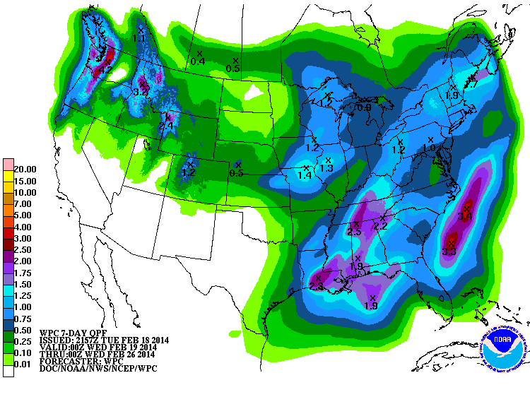
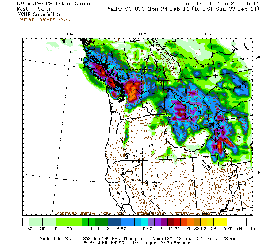
The NWS's GFS model and their Quantitative Precipitation Forecasts still show up to 2-4" more precip over the rest of this week for the mountains of Washington and northern Oregon, with 1-2" in southwestern BC , and much smaller amounts of only a fraction of an inch extending south into the California Cascades and northern Sierra. Here is total precipitation in inches predicted over the next 7 days through Tuesday afternoon, February 25, with most of that shown in the Pacific Northwest falling in the next 4 days though Saturday:
Another strong system arrived on Tuesday morning, once again aimed at southwestern BC and Washington, then shifted southward to Oregon by the afternoon and eventually into northernmost California overnight. This system produced another 1-2 ft of snowfall in less than 16 hours at many sites in southwestern BC, Washington, and northern Oregon, on top of 2-3 ft that had fallen the previous day. The next weaker wave of snowfall will come ashore on Wednesday morning, then the next strong system is projected to arrive late Wednesday into southwestern BC and Washington again, lasting through the day Thursday with snowfall again shifting into Oregon, with some light snowfall lingering into Friday.
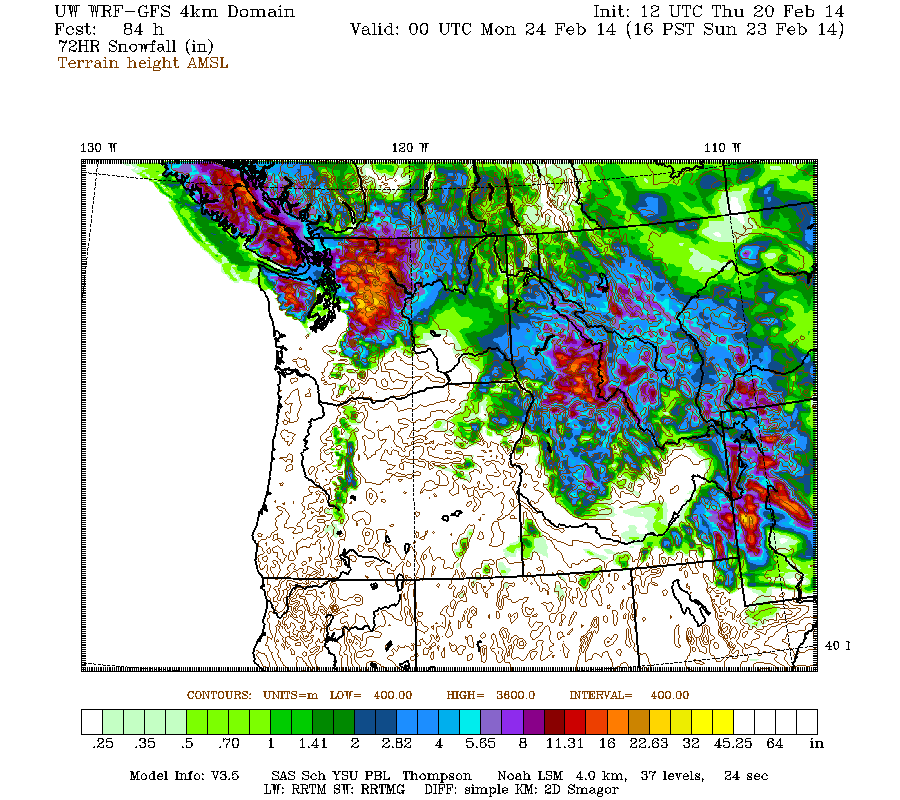
Snowfall during the next 3 days through 4pm Friday is predicted to be 2-4 ft over the west slopes and volcanic peaks of the Washington and northern Oregon Cascades, the Olympics, and south-central BC coast, with 1-2 ft in southwestern BC and the southern Oregon Cascades, and perhaps up to 6" extending into the California Cascades and Trinity Alps tonight:
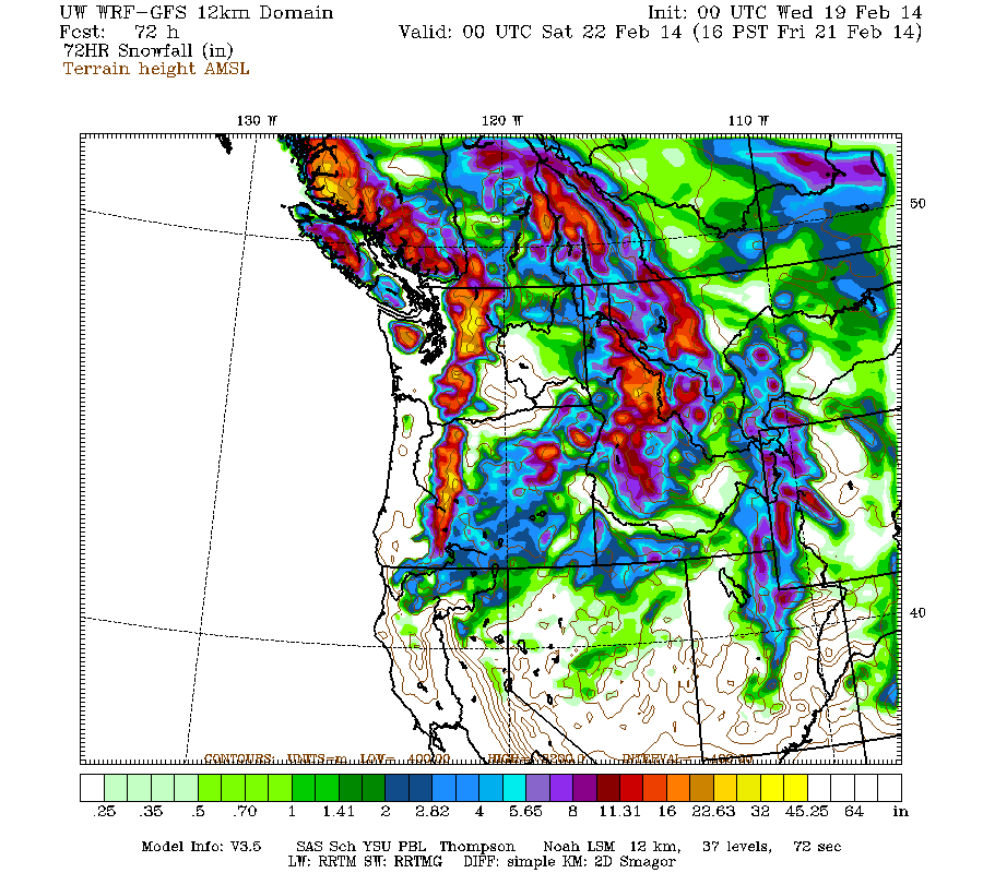
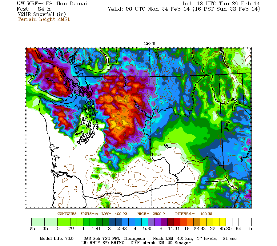
Higher resolution version of that, showing the Pacific Northwest and also zoomed in on Washington and Oregon:
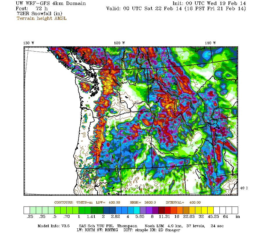
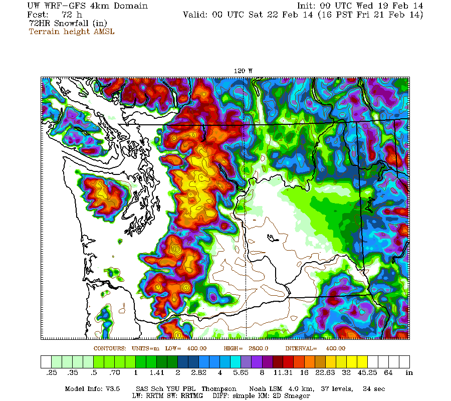
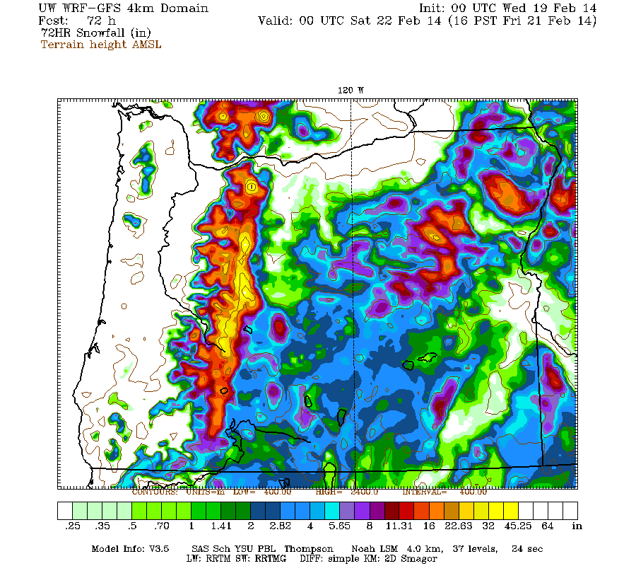
Maximum snowfall amounts of about 4 ft (marked by white inside yellow) are shown only high up on Mounts Hood, Jefferson, and the Three Sisters in Oregon, with 3-4 ft along the west slopes and volcanic peaks of the Washington Cascades and other areas of the Oregon Cascades plus the Olympics.
This loop shows how the model predictions for snowfall during the 3-day period through 4pm Friday have evolved between 10 subsequent runs over the last 5 days, the D(model)/D(t). Very consistent in the overall picture throughout although with snowfall amounts decreasing a bit in later runs, but no major changes other than a significant reduction in snowfall for northern California:
www.atmos.washington.edu/~ovens/wxloop.c...2+v2014022200///+-st
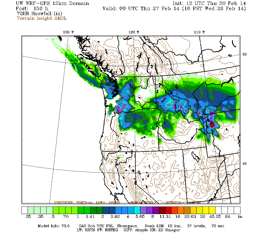
Friday is predicted to be a lull between systems, but then an additional system is expected to come ashore from the northwest early Saturday. Additional snowfall during the subsequent 3 days ending 4pm next Monday is predicted to be another 1-2 ft over the Washington Cascades and southwestern BC, with perhaps several inches extending into northern Oregon:
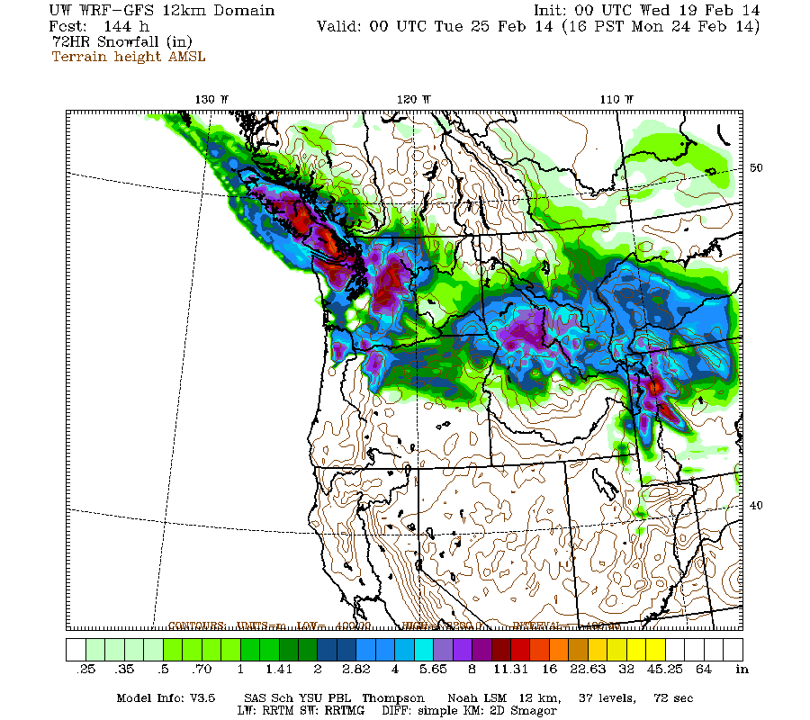
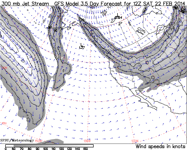
This represents an extension of this storm cycle from earlier model runs several days ago (but similar to predictions over the last 2 days), by roughly 24-48 hours and mainly in the Washington Cascades and southwestern BC, where the northwesterly jet stream shifting eastward onto the Pacific coast is predicted produce an additional moderate system on Saturday. This storm cycle just doesn't seem to want to fade away quietly! Looking at the jet stream predictions (see Days 1-5 Jet Stream Analysis & Forecasts ), it appears that this final storm's development is predicted to occur in the favorable right entrance region of the eastward-departing jet:
The predictions for this period have been changing significantly on subsequent model runs, which often happens during the period following a major storm or storm cycle, as the details of the evolution of those storms has a large effect on predicted and actual weather for the next few days afterward. So it's best not to give too much weight to the predictions for that additional final system on this weekend, until at least another day or so has passed and the models become more consistent in their predictions.
including 2-4 ft in the past 48 hours, with an additional 2-4 ft predicted the rest of this week for WA, OR, and southwest BC!
The climax of this storm cycle has been going off in the Pacific Northwest the past 2 days, the most intense period of snowfall thus far in the 2013-14 season! The heavy snowfall for Washington and Oregon is expected to continue through Thursday, with several more feet of new powder at further lowering snow levels. Epic!
A late-night update this time! Another day-and-half later, and 3 more subsequent runs of the UW WRF-GFS model at 12-hour intervals continue to predict heavy snowfall through Thursday with additional snowfall of 2-4 ft over the rest of this week for Washington, Oregon, and southwest BC. This is all on top of 2-10 ft of snow which has already fallen over the past 12+ days since this storm cycle began on February 6 at most mountain measurement sites along the Pacific coast from Alyeska near Anchorage, Alaska, all the way south to Mammoth Mountain, a span of about 2100 miles as the crow flies (and over 3100 miles by car ). The snowfall over this vast distance is all due to low-pressure systems spawned from the same upper-level parent low in the Gulf of Alaska which has been associated with this entire storm cycle.
This one is now solidly in the HUGE storm cycle category with snowfall amounts reaching 10 ft at several measurement sites already as of Tuesday evening (see the extensive table in the previous post), and 16-day snowfall totals through the end of this week certain to exceed 10-12 ft at many sites especially above 4000-5000 ft in the Washington and northern Oregon Cascades plus southwestern BC. Overall, this storm cycle has been another big win for the predictive capabilities of the weather models especially the UW model, with almost everything throughout the past 2 weeks proceeding reasonably similar to model predictions made 4-7 days ahead (the range of accurate numerical weather prediction), and no major errors or unexpected surprises yet.
The NWS's GFS model and their Quantitative Precipitation Forecasts still show up to 2-4" more precip over the rest of this week for the mountains of Washington and northern Oregon, with 1-2" in southwestern BC , and much smaller amounts of only a fraction of an inch extending south into the California Cascades and northern Sierra. Here is total precipitation in inches predicted over the next 7 days through Tuesday afternoon, February 25, with most of that shown in the Pacific Northwest falling in the next 4 days though Saturday:
Another strong system arrived on Tuesday morning, once again aimed at southwestern BC and Washington, then shifted southward to Oregon by the afternoon and eventually into northernmost California overnight. This system produced another 1-2 ft of snowfall in less than 16 hours at many sites in southwestern BC, Washington, and northern Oregon, on top of 2-3 ft that had fallen the previous day. The next weaker wave of snowfall will come ashore on Wednesday morning, then the next strong system is projected to arrive late Wednesday into southwestern BC and Washington again, lasting through the day Thursday with snowfall again shifting into Oregon, with some light snowfall lingering into Friday.
Snowfall during the next 3 days through 4pm Friday is predicted to be 2-4 ft over the west slopes and volcanic peaks of the Washington and northern Oregon Cascades, the Olympics, and south-central BC coast, with 1-2 ft in southwestern BC and the southern Oregon Cascades, and perhaps up to 6" extending into the California Cascades and Trinity Alps tonight:
Higher resolution version of that, showing the Pacific Northwest and also zoomed in on Washington and Oregon:
Maximum snowfall amounts of about 4 ft (marked by white inside yellow) are shown only high up on Mounts Hood, Jefferson, and the Three Sisters in Oregon, with 3-4 ft along the west slopes and volcanic peaks of the Washington Cascades and other areas of the Oregon Cascades plus the Olympics.
This loop shows how the model predictions for snowfall during the 3-day period through 4pm Friday have evolved between 10 subsequent runs over the last 5 days, the D(model)/D(t). Very consistent in the overall picture throughout although with snowfall amounts decreasing a bit in later runs, but no major changes other than a significant reduction in snowfall for northern California:
www.atmos.washington.edu/~ovens/wxloop.c...2+v2014022200///+-st
Friday is predicted to be a lull between systems, but then an additional system is expected to come ashore from the northwest early Saturday. Additional snowfall during the subsequent 3 days ending 4pm next Monday is predicted to be another 1-2 ft over the Washington Cascades and southwestern BC, with perhaps several inches extending into northern Oregon:
This represents an extension of this storm cycle from earlier model runs several days ago (but similar to predictions over the last 2 days), by roughly 24-48 hours and mainly in the Washington Cascades and southwestern BC, where the northwesterly jet stream shifting eastward onto the Pacific coast is predicted produce an additional moderate system on Saturday. This storm cycle just doesn't seem to want to fade away quietly! Looking at the jet stream predictions (see Days 1-5 Jet Stream Analysis & Forecasts ), it appears that this final storm's development is predicted to occur in the favorable right entrance region of the eastward-departing jet:
The predictions for this period have been changing significantly on subsequent model runs, which often happens during the period following a major storm or storm cycle, as the details of the evolution of those storms has a large effect on predicted and actual weather for the next few days afterward. So it's best not to give too much weight to the predictions for that additional final system on this weekend, until at least another day or so has passed and the models become more consistent in their predictions.
Please Log in or Create an account to join the conversation.
- RonL
-
- User
-
Less
More
- Posts: 259
- Thank you received: 0
12 years 4 months ago #220541
by RonL
Replied by RonL on topic Re: HUGE storm cycle brings 4-12 ft snow Feb6-21,2014!
Your storm reports continue to bring great news. It is so nice to see the local runs back to normal. Thanks for including the % of normals in there since that was what I was wondering about when I logged in. I spent a couple of days early this week in powder with friends in Colorado and came home to find winter restored. It was not easy breaking trail yesterday but it was a good problem to have.
Please Log in or Create an account to join the conversation.
- Amar Andalkar
-
Topic Author
- User
-
Less
More
- Posts: 635
- Thank you received: 0
12 years 4 months ago - 12 years 3 months ago #220634
by Amar Andalkar
Replied by Amar Andalkar on topic Re: HUGE storm cycle brings 4-12 ft snow Feb6-21,2014!
Update #12: 336 hours (2 weeks) after initial post, 2-12 ft of snow has already fallen along the coast from Alaska to California,
including 4-8 ft in the past 5 days for WA, OR, and southwest BC, with an additional 1-2 ft predicted through Monday!
[size=small]Enjoyed an outstanding powder day at Crystal Mountain yesterday, yo-yoing over 50,000 vert in 30 deep powder laps off Rainier Express and the gondola, with at least some untracked powder on every run right through day's end. About 12-24" of new snow (very cold and dry, almost true blower pow, but medium-low density due to winds aloft during the snowfall) sitting atop about 4 ft of recent snow, and another 3-4" new falling throughout the day. Shockingly there were no crowds or lines at all after 9:30am following the morning rush, and the whole place was basically empty after 11am (maybe most people were waiting in line at High Campbell! I stayed away from that). It felt like a throwback to the halcyon seasons of yore (roughly pre-2009) when midweek powder days at Crystal were actually enjoyable and uncrowded and hassle-free, not the crazy overcrowded zoo that it often is nowadays given the increase in job-flexibility for so many people. Easily my best lift-served day of the last couple seasons, and nicely making up for Monday's nightmare with 6 hours of driving in heavy traffic and no skiing at all due to Crystal's power outage closure. Anyway, on to the update:[/size]
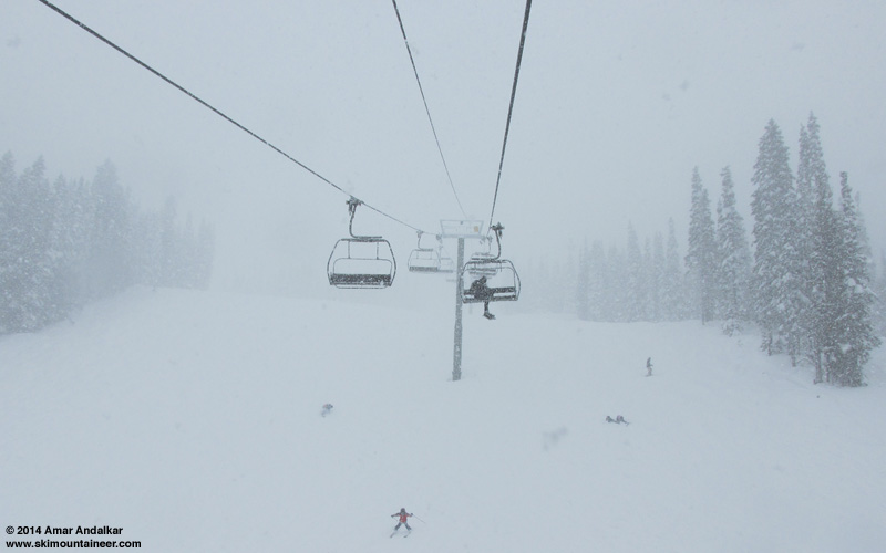
[size=small]Crystal Mountain powder day, snowing hard at noon, February 19.[/size]
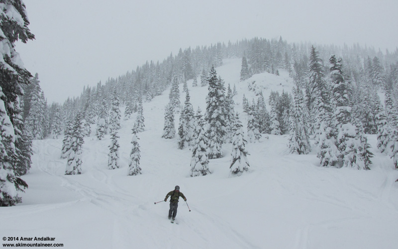
[size=small]Crystal Mountain powder day, still semi-untracked in the right places on the last lap at 3:45pm, February 19.[/size]
[hr]The final days of this lengthy storm cycle have arrived, following the most intense period of snowfall thus far in the 2013-14 season in the Pacific Northwest over the past 5 days, with several feet of new powder at lowering snow levels! The heavy snowfall for Washington and Oregon is expected to continue through Thursday into early Friday, with a final burst of snowfall over the weekend into Monday.
Another day-and-half later, and 3 more subsequent runs of the UW WRF-GFS model at 12-hour intervals continue to predict heavy snowfall through Thursday, a lull on Friday afternoon into Saturday, and then the final system of this storm cycle over the weekend, with additional snowfall of 1-2 ft through Monday for Washington, Oregon, and southwest BC. This is on top of 2-12 ft of snow which has already fallen over the past 14 days since this storm cycle began on February 6 at most mountain measurement sites along the Pacific coast from Alyeska near Anchorage, Alaska, all the way south to Mammoth Mountain, a span of about 2100 miles as the crow flies (and over 3100 miles by car ). The snowfall over this vast distance is all due to low-pressure systems spawned from the same upper-level parent low in the Gulf of Alaska which has been associated with this entire storm cycle.
This one is now solidly in the HUGE storm cycle category with 14-day total snowfall amounts reaching 10-12 ft at several measurement sites already as of Thursday, and final snowfall totals through Monday certain to reach that mark at many other sites especially above 4000-5000 ft in the Washington and northern Oregon Cascades plus southwestern BC. Overall, this storm cycle has been another big win for the predictive capabilities of the weather models especially the UW model, with almost everything throughout the past 2 weeks proceeding reasonably similar to model predictions made 4-7 days ahead (the range of accurate numerical weather prediction), and no major errors or unexpected surprises yet. Perhaps the biggest surprise has been the predicted continuation of this storm cycle through the weekend, with a final moderate system now looking very likely to develop in northwesterly flow on Saturday and last through Monday.
Over the last 2 days, another strong system arrived on Tuesday morning, once again aimed at southwestern BC and Washington, then shifted southward to Oregon by the afternoon and eventually into northernmost California overnight. This system produced another 1-2 ft of snowfall in 24 hours at many sites in southwestern BC, Washington, and northern Oregon, on top of 2-3 ft that had fallen the previous day. A weaker wave of snowfall came ashore on Wednesday morning, then the final strong system arrived late Wednesday into southwestern BC and Washington again, lasting through the day Thursday with snowfall again shifting into Oregon, with some light snowfall expected to linger into Friday. New snowfall amounts have once again topped 1-2 ft in 36 hours from early Wednesday through Thursday afternoon at many sites from Stevens Pass south to Mount Hood, with up to 1 ft in southwestern BC, the North Cascades, and farther south in Oregon, with a few inches extending down to Crater Lake. Beyond that in northern California, this storm cycle had effectively ended long ago with only a few inches of snow overnight Tuesday-Wednesday and skies mostly sunny again for the fifth day in a row since Sunday:
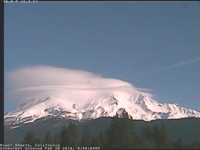
[size=small]Mount Shasta capped by an awesome complex of lenticular clouds on Thursday morning, as seen on the SnowCrest webcam .[/size]
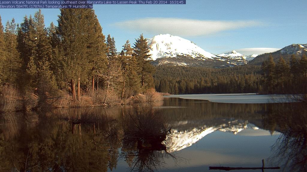
[size=small]Lassen Peak with a lenticular of its own on Thursday afternoon, both reflected in the Manzanita Lake webcam .[/size]
Snowfall during the next 3 days through 4pm Sunday (which catches the end of Thursday's system and the first part of the weekend system) is predicted to be 1-2 ft over Vancouver Island, the Olympics, and northern Washington Cascades, with several inches for much of southwestern BC and only a few inches extending south into the Oregon Cascades tonight:
Higher resolution version of that, showing the Pacific Northwest and also zoomed in on Washington:
The most unusual thing about this image is the large area of lowland snowfall predicted from roughly Seattle northward throughout the northern Puget Sound, San Juan Islands, Bellingham area, Vancouver, and the Strait of Georgia, with amounts ranging up to several inches for late Saturday. This is due to the cold air brought in by the strong northwesterly flow over the region (see jet stream graphic at end of the previous post, Update #11 above). It will be interesting to see if this prediction verifies, since lowland snowfall is notoriously difficult to predict accurately in this region.
This loop shows how the model predictions for snowfall during the 3-day period through 4pm Sunday have evolved between 10 subsequent runs over the last 5 days, the D(model)/D(t). Unlike most of these loops shown previously in this thread, this one has varied wildly in its predictions, especially several days ago, but has become a bit more consistent in the most recent runs. That reflects the uncertainty over how this storm cycle would end, and the unexpected final system now predicted over the weekend:
www.atmos.washington.edu/~ovens/wxloop.c...2+v2014022400///+-st
Additional snowfall during the subsequent 3 days ending 4pm next Wednesday is predicted to be another 2-8" over the Olympics, Washington Cascades (except the North Cascades), and northern Oregon Cascades. This catches the latter part of the weekend system, and snowfall is expected to end by late Monday or early Tuesday:
Details beyond that point (after the end of this storm cycle) remain murky, with little agreement between models or run-to-run consistency in a single model. A new system may perhaps develop farther south and head into California in the latter half of next week.
[hr]Snowpack summary:
Table of snowpack percent of normal at selected sites as of Thursday, February 20. The normal values have been interpolated between the February 15 and March 1 values for those sites for which daily normal values are not available from WRCC . Normal snowdepth values are not available at all for most SNOTEL, BCRFC, and CCSS telemetry sites, since snowdepth sensors were only installed on most of those sites within the past decade. Approximate normal values can be estimated for some of these telemetry sites if they are co-located with a manual snow course which has several decades of snowdepth records near the first of each month. And obviously, the percent of normal will decrease over the next several days as snowfall lessens and the huge amounts of new snow begin to settle and compact. At least until the next big storm cycle!
[tt]
Feb 20
Current Normal Percent of
Measurement Site Elevation Snowdepth Snowdepth Normal
==== British Columbia ====
Tenquille Lake BCRFC 5480 ft 95" 102" 93% (normals estimated)
Whistler Mountain 5400 ft 91" 91" 100%
Whistler Village 2200 ft 28" 21" 133%
Chilliwack River BCRFC 5320 ft 152" 122" 125%
======= Washington =======
Hurricane Ridge 5250 ft 90" 88" 102%
Mt Baker Ski Area 4200 ft 144" 143" 101%
Rainy Pass SNOTEL 4890 ft 110" 96" 115% (normals estimated)
Mazama 2170 ft 41" 29" 140%
Holden Village 3220 ft 72" 60" 120% ***
Lyman Lake SNOTEL 5980 ft 145" 134" 108% (normals estimated)
Stevens Pass NWAC 3950 ft 126" 96" 131%
Mission Ridge 5160 ft 54" 44" 123%
Snoqualmie Pass 3000 ft 99" 87" 114%
Stampede Pass SNOTEL 3850 ft 103" 94" 110%
Crystal Mtn, Green Valley 6230 ft 133" 97" 137% (only 10 years data)
Crystal Mtn Base 4570 ft 82" 63" 130%
Mt Rainier, Paradise 5400 ft 178" 148" 120%
Mt Rainier, Longmire 2700 ft 29" 32" 91%
White Pass 4440 ft 77" 56" 138%
========= Oregon =========
Mt Hood, Red Hill SNOTEL 4410 ft 88" 82" 107% (normals estimated)
Mt Hood, Timberline Lodge 5880 ft 142" 134" 106%
Mt Hood, Meadows Ski Area 5380 ft 124" 112" 111%
McKenzie SNOTEL 4770 ft 77" 86" 90% (normals estimated)
Three Creeks Meadow SNOTEL 5690 ft 41" 43" 95% (normals estimated)
Mt Bachelor, West Village 6300 ft 117" 94" 125% (normals estimated)
Cascade Summit SNOTEL 5100 ft 55" 66" 83% (normals estimated)
Diamond Peak, Summit Lake 5610 ft 60" 92" 65% (normals estimated)
Crater Lake, Park HQ 6470 ft 57" 107" 53%
Crater Lake, Annie Springs 6000 ft 45" 93" 48% (normals estimated)
Pelican Butte, Cold Springs 5940 ft 32" 74" 43% (normals estimated)
Mt McLoughlin, Fourmile Lake 5970 ft 27" 56" 48% (normals estimated)
======= California =======
Medicine Lake 6700 ft 11" 60" 18% (normals estimated)
Mt Shasta, Old Ski Bowl 7600 ft 28" 103" 27% (normals estimated)
Mt Shasta, Sand Flat 6750 ft 14" 88" 16% (normals estimated)
[/tt]
[size=small]*** I was shocked to discover right now while compiling this table that February 20 happens to be the date of maximum average snowdepth at Holden Village -- most mountain sites above 3000 ft in the WA Cascades have their maximum average snowdepth in mid-March or later, typically around April 1 and as late as mid-April at some high elevation sites. February 20 seems almost freakishly early in comparison, although the maximum average snowdepth does tend to occur in February at lower elevation sites like Mazama.[/size]
As I expected several days ago (see Update #9 above), snowdepths in southwestern BC, the Olympics, Washington Cascades, and northern Oregon Cascades are now at or above normal at sites above about 2000 ft in BC, 3000 ft in WA, and 5000 ft in northern OR. Snowdepths in the southern Oregon Cascades remain far below normal, while those in the California Cascades are still catastrophically below normal even at the highest elevation measurement sites.
The 178" at Mount Rainier Paradise is apparently now the largest snowdepth of any telemetry site in North America (as far as I know, unless I missed something), a familiar position for Paradise in many a season. Other telemetry sites in the same ballpark (over 140") not listed in the table above include the Brown Top SNOTEL (5800 ft near Mount Redoubt in the North Cascades) at 153", Stevens Pass with at Grace Lakes (4800 ft) at 164" and top of Skyline (5250 ft) at 145", Paradise SNOTEL (5120 ft) at 165", and the top of White Pass Ski Area (5800 ft) with the NWAC site at 163" and the adjacent Pigtail Peak SNOTEL at 160". Manually measured sites in that range include 163" atop Pan Dome (5000 ft) at Mount Baker Ski Area, 168" atop Alpental (5470 ft), and 150" at Mount Bachelor mid-mountain (7300 ft).
including 4-8 ft in the past 5 days for WA, OR, and southwest BC, with an additional 1-2 ft predicted through Monday!
[size=small]Enjoyed an outstanding powder day at Crystal Mountain yesterday, yo-yoing over 50,000 vert in 30 deep powder laps off Rainier Express and the gondola, with at least some untracked powder on every run right through day's end. About 12-24" of new snow (very cold and dry, almost true blower pow, but medium-low density due to winds aloft during the snowfall) sitting atop about 4 ft of recent snow, and another 3-4" new falling throughout the day. Shockingly there were no crowds or lines at all after 9:30am following the morning rush, and the whole place was basically empty after 11am (maybe most people were waiting in line at High Campbell! I stayed away from that). It felt like a throwback to the halcyon seasons of yore (roughly pre-2009) when midweek powder days at Crystal were actually enjoyable and uncrowded and hassle-free, not the crazy overcrowded zoo that it often is nowadays given the increase in job-flexibility for so many people. Easily my best lift-served day of the last couple seasons, and nicely making up for Monday's nightmare with 6 hours of driving in heavy traffic and no skiing at all due to Crystal's power outage closure. Anyway, on to the update:[/size]
[size=small]Crystal Mountain powder day, snowing hard at noon, February 19.[/size]
[size=small]Crystal Mountain powder day, still semi-untracked in the right places on the last lap at 3:45pm, February 19.[/size]
[hr]The final days of this lengthy storm cycle have arrived, following the most intense period of snowfall thus far in the 2013-14 season in the Pacific Northwest over the past 5 days, with several feet of new powder at lowering snow levels! The heavy snowfall for Washington and Oregon is expected to continue through Thursday into early Friday, with a final burst of snowfall over the weekend into Monday.
Another day-and-half later, and 3 more subsequent runs of the UW WRF-GFS model at 12-hour intervals continue to predict heavy snowfall through Thursday, a lull on Friday afternoon into Saturday, and then the final system of this storm cycle over the weekend, with additional snowfall of 1-2 ft through Monday for Washington, Oregon, and southwest BC. This is on top of 2-12 ft of snow which has already fallen over the past 14 days since this storm cycle began on February 6 at most mountain measurement sites along the Pacific coast from Alyeska near Anchorage, Alaska, all the way south to Mammoth Mountain, a span of about 2100 miles as the crow flies (and over 3100 miles by car ). The snowfall over this vast distance is all due to low-pressure systems spawned from the same upper-level parent low in the Gulf of Alaska which has been associated with this entire storm cycle.
This one is now solidly in the HUGE storm cycle category with 14-day total snowfall amounts reaching 10-12 ft at several measurement sites already as of Thursday, and final snowfall totals through Monday certain to reach that mark at many other sites especially above 4000-5000 ft in the Washington and northern Oregon Cascades plus southwestern BC. Overall, this storm cycle has been another big win for the predictive capabilities of the weather models especially the UW model, with almost everything throughout the past 2 weeks proceeding reasonably similar to model predictions made 4-7 days ahead (the range of accurate numerical weather prediction), and no major errors or unexpected surprises yet. Perhaps the biggest surprise has been the predicted continuation of this storm cycle through the weekend, with a final moderate system now looking very likely to develop in northwesterly flow on Saturday and last through Monday.
Over the last 2 days, another strong system arrived on Tuesday morning, once again aimed at southwestern BC and Washington, then shifted southward to Oregon by the afternoon and eventually into northernmost California overnight. This system produced another 1-2 ft of snowfall in 24 hours at many sites in southwestern BC, Washington, and northern Oregon, on top of 2-3 ft that had fallen the previous day. A weaker wave of snowfall came ashore on Wednesday morning, then the final strong system arrived late Wednesday into southwestern BC and Washington again, lasting through the day Thursday with snowfall again shifting into Oregon, with some light snowfall expected to linger into Friday. New snowfall amounts have once again topped 1-2 ft in 36 hours from early Wednesday through Thursday afternoon at many sites from Stevens Pass south to Mount Hood, with up to 1 ft in southwestern BC, the North Cascades, and farther south in Oregon, with a few inches extending down to Crater Lake. Beyond that in northern California, this storm cycle had effectively ended long ago with only a few inches of snow overnight Tuesday-Wednesday and skies mostly sunny again for the fifth day in a row since Sunday:
[size=small]Mount Shasta capped by an awesome complex of lenticular clouds on Thursday morning, as seen on the SnowCrest webcam .[/size]
[size=small]Lassen Peak with a lenticular of its own on Thursday afternoon, both reflected in the Manzanita Lake webcam .[/size]
Snowfall during the next 3 days through 4pm Sunday (which catches the end of Thursday's system and the first part of the weekend system) is predicted to be 1-2 ft over Vancouver Island, the Olympics, and northern Washington Cascades, with several inches for much of southwestern BC and only a few inches extending south into the Oregon Cascades tonight:
Higher resolution version of that, showing the Pacific Northwest and also zoomed in on Washington:
The most unusual thing about this image is the large area of lowland snowfall predicted from roughly Seattle northward throughout the northern Puget Sound, San Juan Islands, Bellingham area, Vancouver, and the Strait of Georgia, with amounts ranging up to several inches for late Saturday. This is due to the cold air brought in by the strong northwesterly flow over the region (see jet stream graphic at end of the previous post, Update #11 above). It will be interesting to see if this prediction verifies, since lowland snowfall is notoriously difficult to predict accurately in this region.
This loop shows how the model predictions for snowfall during the 3-day period through 4pm Sunday have evolved between 10 subsequent runs over the last 5 days, the D(model)/D(t). Unlike most of these loops shown previously in this thread, this one has varied wildly in its predictions, especially several days ago, but has become a bit more consistent in the most recent runs. That reflects the uncertainty over how this storm cycle would end, and the unexpected final system now predicted over the weekend:
www.atmos.washington.edu/~ovens/wxloop.c...2+v2014022400///+-st
Additional snowfall during the subsequent 3 days ending 4pm next Wednesday is predicted to be another 2-8" over the Olympics, Washington Cascades (except the North Cascades), and northern Oregon Cascades. This catches the latter part of the weekend system, and snowfall is expected to end by late Monday or early Tuesday:
Details beyond that point (after the end of this storm cycle) remain murky, with little agreement between models or run-to-run consistency in a single model. A new system may perhaps develop farther south and head into California in the latter half of next week.
[hr]Snowpack summary:
Table of snowpack percent of normal at selected sites as of Thursday, February 20. The normal values have been interpolated between the February 15 and March 1 values for those sites for which daily normal values are not available from WRCC . Normal snowdepth values are not available at all for most SNOTEL, BCRFC, and CCSS telemetry sites, since snowdepth sensors were only installed on most of those sites within the past decade. Approximate normal values can be estimated for some of these telemetry sites if they are co-located with a manual snow course which has several decades of snowdepth records near the first of each month. And obviously, the percent of normal will decrease over the next several days as snowfall lessens and the huge amounts of new snow begin to settle and compact. At least until the next big storm cycle!
[tt]
Feb 20
Current Normal Percent of
Measurement Site Elevation Snowdepth Snowdepth Normal
==== British Columbia ====
Tenquille Lake BCRFC 5480 ft 95" 102" 93% (normals estimated)
Whistler Mountain 5400 ft 91" 91" 100%
Whistler Village 2200 ft 28" 21" 133%
Chilliwack River BCRFC 5320 ft 152" 122" 125%
======= Washington =======
Hurricane Ridge 5250 ft 90" 88" 102%
Mt Baker Ski Area 4200 ft 144" 143" 101%
Rainy Pass SNOTEL 4890 ft 110" 96" 115% (normals estimated)
Mazama 2170 ft 41" 29" 140%
Holden Village 3220 ft 72" 60" 120% ***
Lyman Lake SNOTEL 5980 ft 145" 134" 108% (normals estimated)
Stevens Pass NWAC 3950 ft 126" 96" 131%
Mission Ridge 5160 ft 54" 44" 123%
Snoqualmie Pass 3000 ft 99" 87" 114%
Stampede Pass SNOTEL 3850 ft 103" 94" 110%
Crystal Mtn, Green Valley 6230 ft 133" 97" 137% (only 10 years data)
Crystal Mtn Base 4570 ft 82" 63" 130%
Mt Rainier, Paradise 5400 ft 178" 148" 120%
Mt Rainier, Longmire 2700 ft 29" 32" 91%
White Pass 4440 ft 77" 56" 138%
========= Oregon =========
Mt Hood, Red Hill SNOTEL 4410 ft 88" 82" 107% (normals estimated)
Mt Hood, Timberline Lodge 5880 ft 142" 134" 106%
Mt Hood, Meadows Ski Area 5380 ft 124" 112" 111%
McKenzie SNOTEL 4770 ft 77" 86" 90% (normals estimated)
Three Creeks Meadow SNOTEL 5690 ft 41" 43" 95% (normals estimated)
Mt Bachelor, West Village 6300 ft 117" 94" 125% (normals estimated)
Cascade Summit SNOTEL 5100 ft 55" 66" 83% (normals estimated)
Diamond Peak, Summit Lake 5610 ft 60" 92" 65% (normals estimated)
Crater Lake, Park HQ 6470 ft 57" 107" 53%
Crater Lake, Annie Springs 6000 ft 45" 93" 48% (normals estimated)
Pelican Butte, Cold Springs 5940 ft 32" 74" 43% (normals estimated)
Mt McLoughlin, Fourmile Lake 5970 ft 27" 56" 48% (normals estimated)
======= California =======
Medicine Lake 6700 ft 11" 60" 18% (normals estimated)
Mt Shasta, Old Ski Bowl 7600 ft 28" 103" 27% (normals estimated)
Mt Shasta, Sand Flat 6750 ft 14" 88" 16% (normals estimated)
[/tt]
[size=small]*** I was shocked to discover right now while compiling this table that February 20 happens to be the date of maximum average snowdepth at Holden Village -- most mountain sites above 3000 ft in the WA Cascades have their maximum average snowdepth in mid-March or later, typically around April 1 and as late as mid-April at some high elevation sites. February 20 seems almost freakishly early in comparison, although the maximum average snowdepth does tend to occur in February at lower elevation sites like Mazama.[/size]
As I expected several days ago (see Update #9 above), snowdepths in southwestern BC, the Olympics, Washington Cascades, and northern Oregon Cascades are now at or above normal at sites above about 2000 ft in BC, 3000 ft in WA, and 5000 ft in northern OR. Snowdepths in the southern Oregon Cascades remain far below normal, while those in the California Cascades are still catastrophically below normal even at the highest elevation measurement sites.
The 178" at Mount Rainier Paradise is apparently now the largest snowdepth of any telemetry site in North America (as far as I know, unless I missed something), a familiar position for Paradise in many a season. Other telemetry sites in the same ballpark (over 140") not listed in the table above include the Brown Top SNOTEL (5800 ft near Mount Redoubt in the North Cascades) at 153", Stevens Pass with at Grace Lakes (4800 ft) at 164" and top of Skyline (5250 ft) at 145", Paradise SNOTEL (5120 ft) at 165", and the top of White Pass Ski Area (5800 ft) with the NWAC site at 163" and the adjacent Pigtail Peak SNOTEL at 160". Manually measured sites in that range include 163" atop Pan Dome (5000 ft) at Mount Baker Ski Area, 168" atop Alpental (5470 ft), and 150" at Mount Bachelor mid-mountain (7300 ft).
Please Log in or Create an account to join the conversation.
- Amar Andalkar
-
Topic Author
- User
-
Less
More
- Posts: 635
- Thank you received: 0
12 years 3 months ago #220660
by Amar Andalkar
Replied by Amar Andalkar on topic Re: HUGE storm cycle brings 4-12 ft snow Feb6-21,2014!
Sunrise after the storm:
With a decent lull between storms on Friday before the final system(s) of this storm cycle arrive over the weekend, skies cleared by sunrise at many mountain locations in southwestern BC, Washington, and Oregon (and remained clear in California), although light to moderate snowfall continued occasionally at other sites, and some of these clear sites soon reverted to snowfall too:
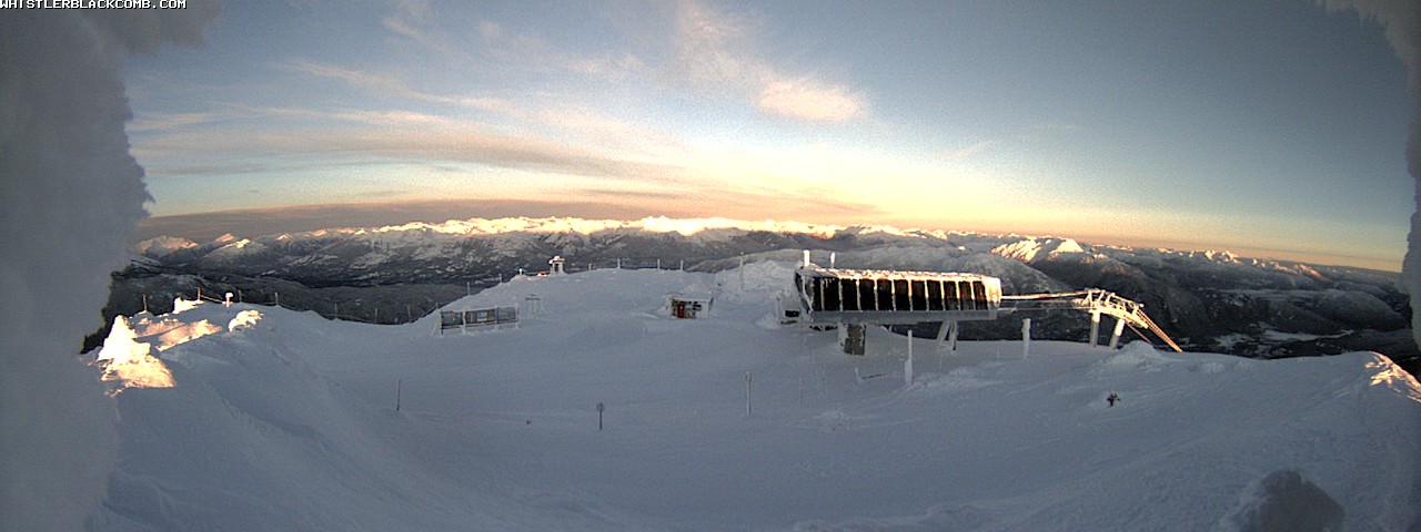
[size=small]Sunrise atop Whistler Mountain, with the volcanic spires of Mount Cayley and the broad icefield domes of Powder Mountain glowing white at center,
as seen on a hidden image formerly linked from the Whistler Peak webcam (2014-02-21 7:23am).[/size]
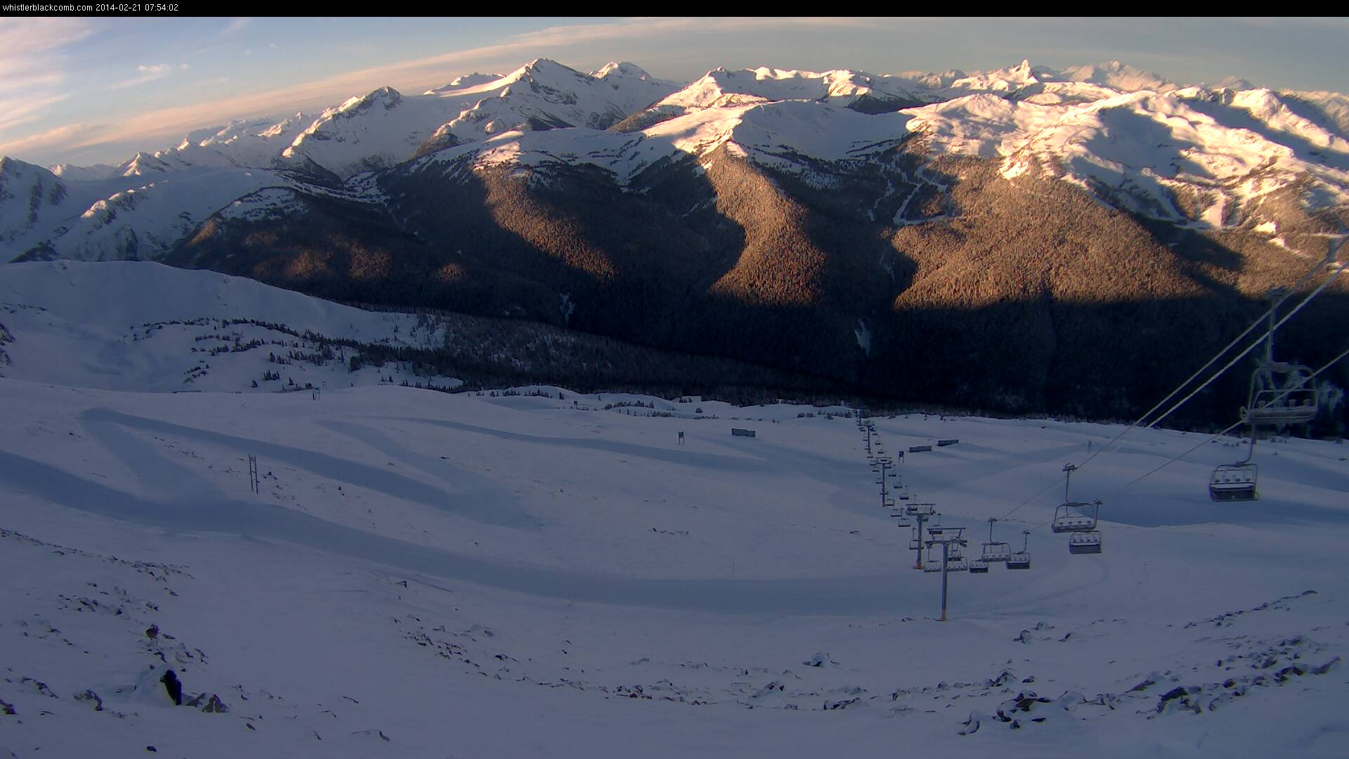
[size=small]Sunrise from atop 7th Heaven on Blackcomb , with the volcanic peaks of Mount Garibaldi (center) and Black Tusk (right) in the distance.[/size]
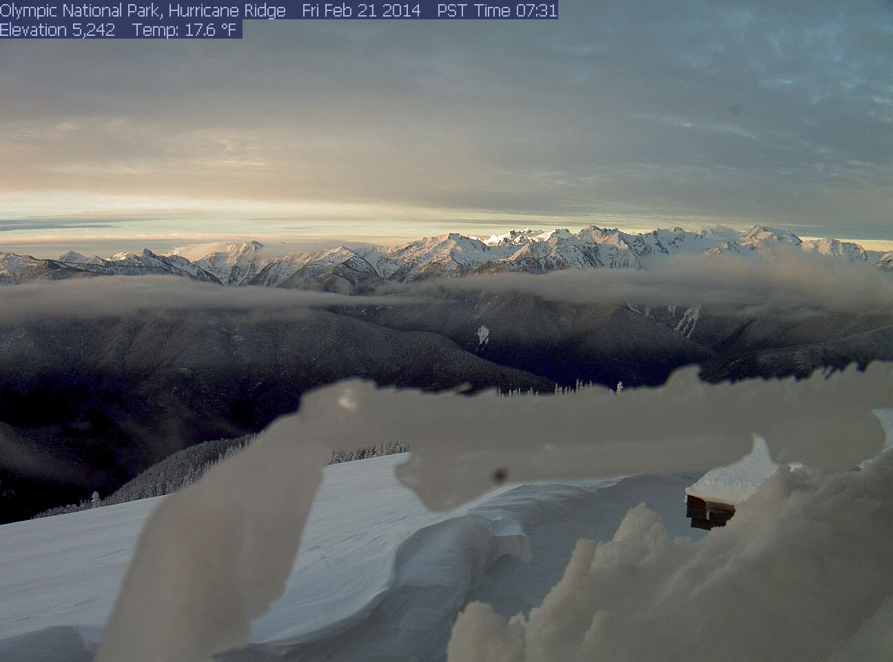
[size=small]Sunrise from Hurricane Ridge , with Mount Olympus shining in the sun at center.[/size]
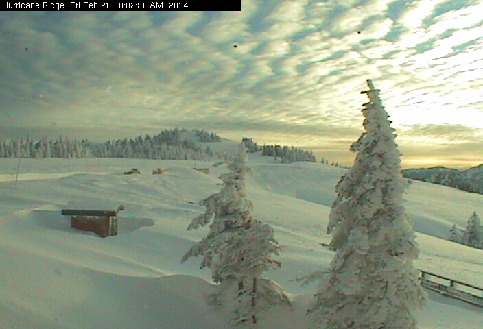
[size=small]Sunrise and cool clouds at Hurricane Ridge , with snow plowing operations in progress -- the road would open by 9:30am
despite several feet of snowfall during the week (road is closed Monday-Thursday in winter).[/size]
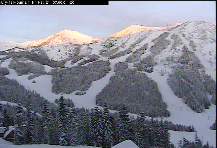
[size=small]Sunrise on the peaks of Crystal Mountain .[/size]
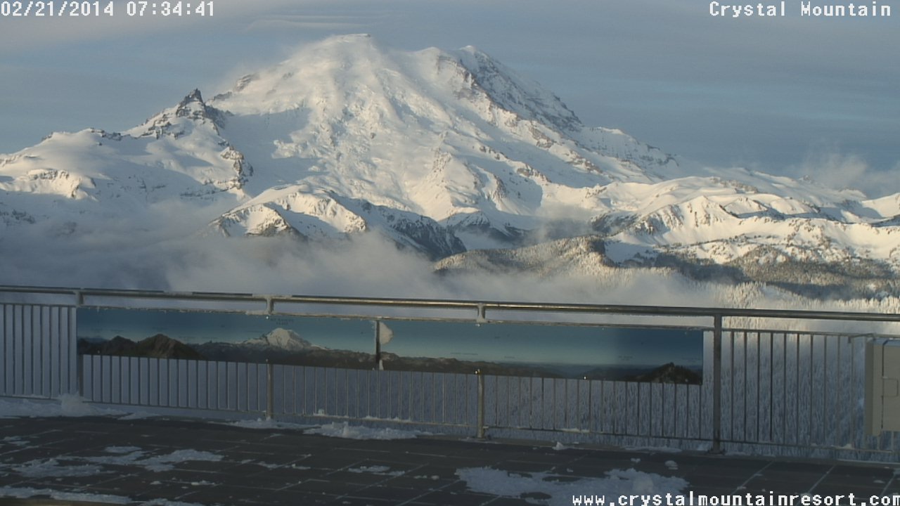
[size=small]Sunrise on Mount Rainier from atop Crystal Mountain , with some interesting thin stacked lenticular clouds above the summit.[/size]
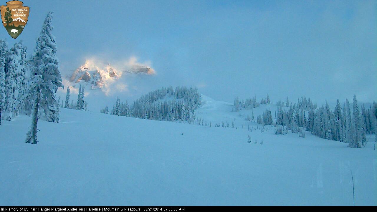
[size=small]Just a brief glimpse of the Mountain from the other side at Paradise .[/size]
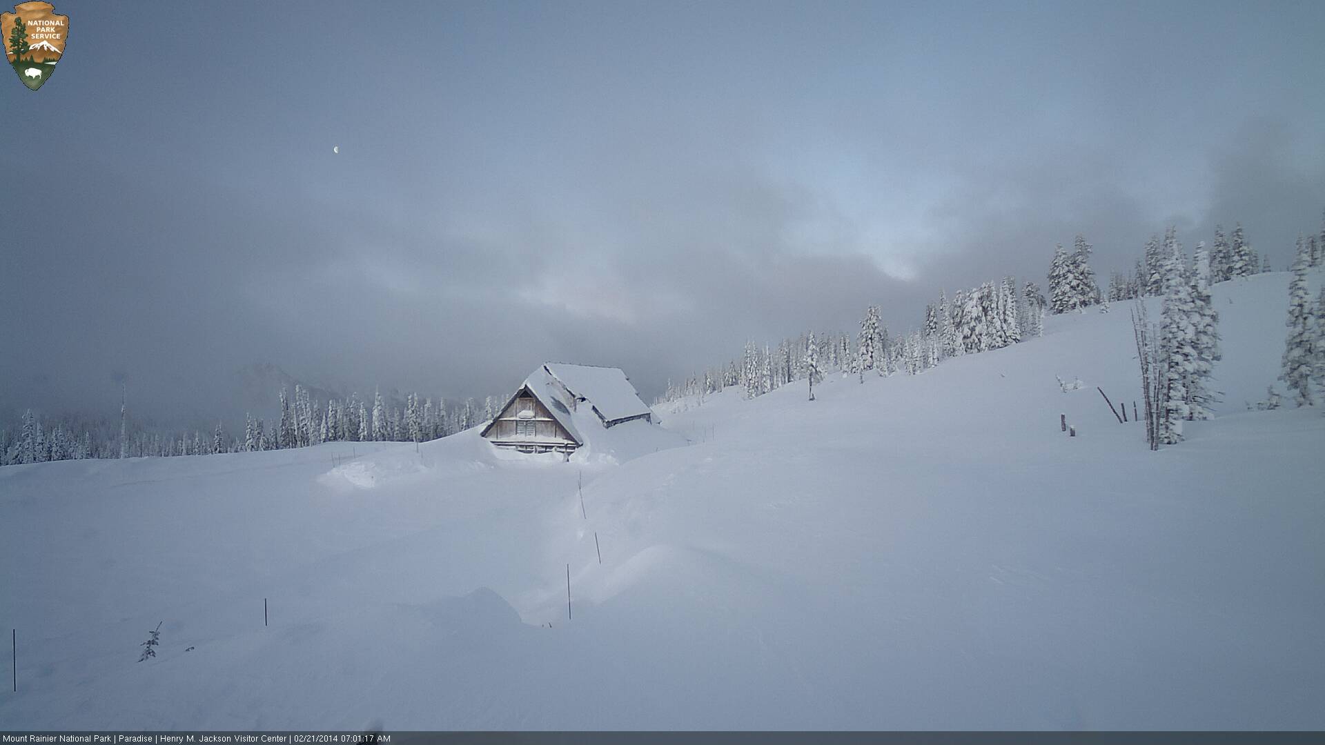
[size=small]Rising run, setting moon, snow-drifted parking lot at Paradise .[/size]
[size=small]Sunrise on Mount Hood from the Columbia River Gorge .[/size]
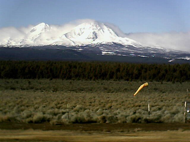
[size=small]Clouds parting after sunrise to reveal North Sister and Middle Sister, as seen on the Cascade Flyers webcam between Bend and Sisters (2014-02-21 8:58am).[/size]
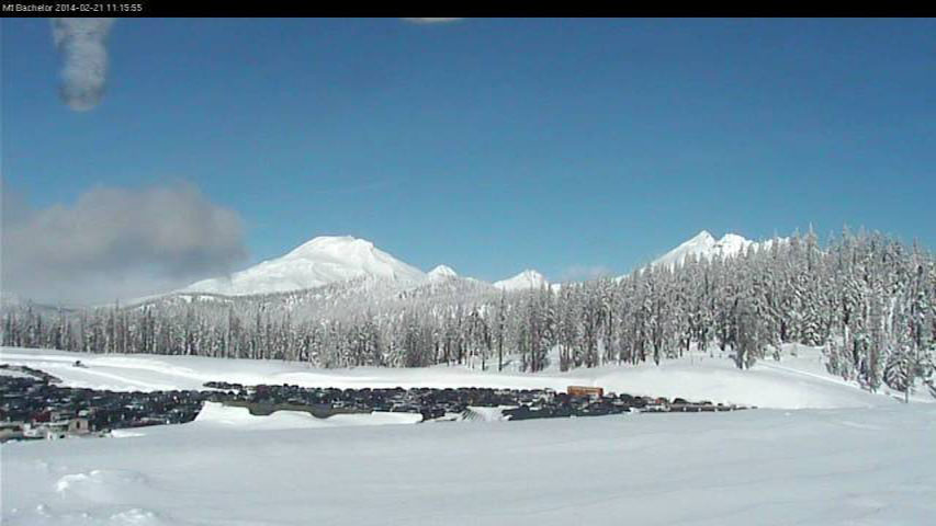
[size=small]Clouds parting by late-morning to reveal South Sister, Middle Sister, North Sister, and Broken Top (left to right) as seen from Mount Bachelor .[/size]
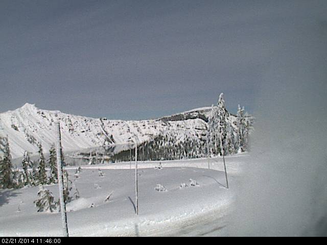
[size=small]The Crater Lake webcam finally defrosted enough by noon to reveal Wizard Island.[/size]
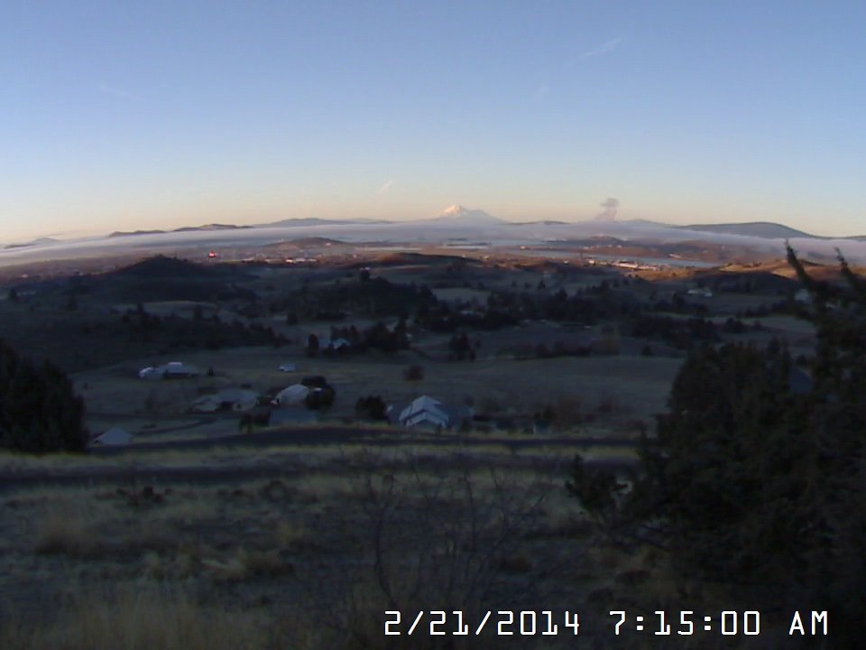
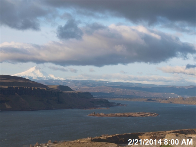
[size=small]Distant view of sunrise on Mount Shasta from 60 miles NE in Klamath Falls .[/size]
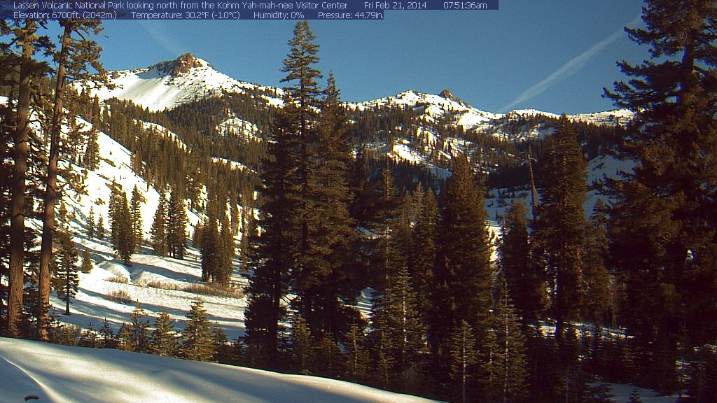
[size=small]Sunrise from the southwest entrance of Lassen Volcanic National Park .[/size]
With a decent lull between storms on Friday before the final system(s) of this storm cycle arrive over the weekend, skies cleared by sunrise at many mountain locations in southwestern BC, Washington, and Oregon (and remained clear in California), although light to moderate snowfall continued occasionally at other sites, and some of these clear sites soon reverted to snowfall too:
[size=small]Sunrise atop Whistler Mountain, with the volcanic spires of Mount Cayley and the broad icefield domes of Powder Mountain glowing white at center,
as seen on a hidden image formerly linked from the Whistler Peak webcam (2014-02-21 7:23am).[/size]
[size=small]Sunrise from atop 7th Heaven on Blackcomb , with the volcanic peaks of Mount Garibaldi (center) and Black Tusk (right) in the distance.[/size]
[size=small]Sunrise from Hurricane Ridge , with Mount Olympus shining in the sun at center.[/size]
[size=small]Sunrise and cool clouds at Hurricane Ridge , with snow plowing operations in progress -- the road would open by 9:30am
despite several feet of snowfall during the week (road is closed Monday-Thursday in winter).[/size]
[size=small]Sunrise on the peaks of Crystal Mountain .[/size]
[size=small]Sunrise on Mount Rainier from atop Crystal Mountain , with some interesting thin stacked lenticular clouds above the summit.[/size]
[size=small]Just a brief glimpse of the Mountain from the other side at Paradise .[/size]
[size=small]Rising run, setting moon, snow-drifted parking lot at Paradise .[/size]
[size=small]Sunrise on Mount Hood from the Columbia River Gorge .[/size]
[size=small]Clouds parting after sunrise to reveal North Sister and Middle Sister, as seen on the Cascade Flyers webcam between Bend and Sisters (2014-02-21 8:58am).[/size]
[size=small]Clouds parting by late-morning to reveal South Sister, Middle Sister, North Sister, and Broken Top (left to right) as seen from Mount Bachelor .[/size]
[size=small]The Crater Lake webcam finally defrosted enough by noon to reveal Wizard Island.[/size]
[size=small]Distant view of sunrise on Mount Shasta from 60 miles NE in Klamath Falls .[/size]
[size=small]Sunrise from the southwest entrance of Lassen Volcanic National Park .[/size]
Please Log in or Create an account to join the conversation.