- Posts: 288
- Thank you received: 0
COLD: Below zero F today at almost all NWAC sites!
- T. Eastman
-

- User
-

Less
More
12 years 6 months ago #211205
by T. Eastman
Replied by T. Eastman on topic Re: COLD: Below zero F today at almost all NWAC sites!
Finally some winter!
Please Log in or Create an account to join the conversation.
- Amar Andalkar
-
Topic Author
- User
-
Less
More
- Posts: 635
- Thank you received: 0
12 years 6 months ago - 12 years 6 months ago #211211
by Amar Andalkar
Replied by Amar Andalkar on topic Re: COLD: Below zero F today at almost all NWAC sites!
Well, the overnight and early morning hours of Saturday, December 7, shown in the data above will remain the coldest period throughout the WA Cascades and Olympics in the last several (perhaps many) years. Somewhat surprisingly, despite forecasts predicting the coldest night of the year at most locations in western WA, the temperatures early on Sunday, December 8, were warmer at almost every single NWAC site, generally by about 5 to 15 °F. The only exceptions which were colder by a few degrees were Mazama 2170', Blewett Pass 4100', and Government Camp 3660'. Only 10 out of 25 operating sites recorded minimums below 0 °F early on December 8, versus the night before when 22 of 25 sites went below 0 °F with 2 other sites reaching 1 °F.
The really cold weather overnight into Sunday, December 8, was farther south, where temperatures dropped below -20 °F throughout most of eastern Oregon, northeastern California, and northern Nevada. Here is a plot of 24-hour minimum temperatures from Mesowest (which collects telemetry from many different networks of sites including RAWS, SNOTEL, AgriMet, DOT, airports, railroads, etc.), go to www.wrh.noaa.gov/mesowest/gmap.php?map=mfr , select "24 hr Max/Min", "24Hr Min Temp", and set the Temps data filter to hide warmer temps:
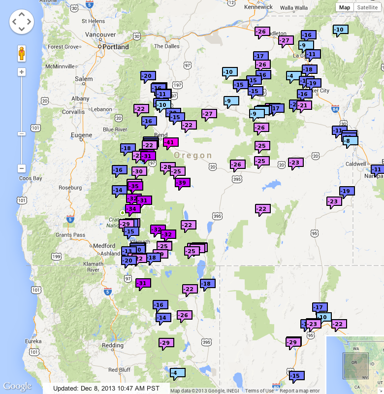
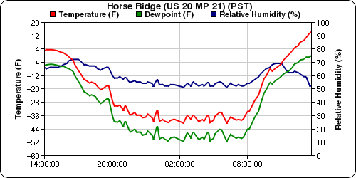
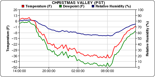
The jackpot was just east of the Cascade Range along the US 97 corridor from Klamath Falls north to Bend, where dozens of sites recorded minimums below -30 °F, capped by -39 °F at the Christmas Valley AgriMet site and -41 °F at the ODOT Horse Ridge site on US 20.
This region consists of broad plains within shallow basins at elevations of 4200-4800 ft, entirely blanketed by several meters of pumice (the Mazama Ash from the climactic eruption which formed Crater Lake about 7700 years ago). The extreme cold overnight was due to a combination of high elevation, partially to completely closed basins where cold air could sink and pool, and several inches of new snowfall Friday-Saturday followed by complete clearing Saturday night to provide very strong radiational cooling.
Minimum temperatures were generally much warmer at higher elevations closer to the volcanoes of the Cascade Crest, although still well below 0 °F at most sites. But one exceptional high-elevation site on the largest of the Cascade volcanoes also dropped below -30 °F: the Medicine Lake CCSS site , located just NW of the lake which fills part of the caldera atop the huge shield of Medicine Lake Volcano . This site is also ideally situated for extreme cold, located at high elevation on a flat pumice plain within a completely closed basin surrounded on all sides by the caldera rim which extends roughly 500-1000 ft above the elevation of the lake, with about 1 ft of new snowfall Friday-Saturday to enhance the radiational cooling.
[tt]
MEDICINE LAKE (MED)
Located just NW of Medicine Lake, 32 miles ENE of Mt Shasta
Elevation: 6700' PIT R basin
Operator: US Bureau of Reclamation
Date / Time SNOW SNOW PRECIP TEMP BAT
WC DEPTH VOL
(PST) (in) (in) (in) (°F) (V)
12/07/2013 12:00 0.96 10 5.59 11 12.4
12/07/2013 13:00 0.96 10 5.59 9 12.4
12/07/2013 14:00 1.08 10 5.59 10 12.8
12/07/2013 15:00 1.08 9 5.59 9 12.9
12/07/2013 16:00 1.08 9 5.73 6 12.7
12/07/2013 17:00 1.08 5 5.73 3 12.4
12/07/2013 18:00 1.08 5 5.59 -1 12.3
12/07/2013 19:00 1.08 9 5.59 -5 12.2
12/07/2013 20:00 0.96 7 5.59 -10 12.1
12/07/2013 21:00 0.96 4 5.46 -12 12.0
12/07/2013 22:00 0.84 4 5.46 -16 12.0
12/07/2013 23:00 0.84 4 5.46 -19 12.0
12/08/2013 00:00 0.72 7 5.33 -21 12.0
12/08/2013 01:00 0.72 8 5.33 -23 11.9
12/08/2013 02:00 0.72 4 5.33 -26 11.9
12/08/2013 03:00 0.72 -- 5.19 -27 11.9
12/08/2013 04:00 0.60 -- 5.19 -28 11.8
12/08/2013 05:00 0.60 -- 5.19 -30 11.8
12/08/2013 06:00 0.60 -- 5.06 -31 11.8
12/08/2013 07:00 0.60 -- 5.06 -31 11.8
12/08/2013 08:00 0.48 -- 5.06 -29 11.7
12/08/2013 09:00 0.48 -- 5.06 -16 12.2
12/08/2013 10:00 0.48 5 4.93 10 12.9
12/08/2013 11:00 0.60 5 5.06 25 13.2
12/08/2013 12:00 0.84 6 5.33 31 13.4
[/tt]
Perhaps even more surprising than the extremely low overnight temperature is how quickly temps are warming this morning under bright sunshine, which looking through older data appears to be a typical pattern after very cold clear nights at this site. The temperature today has risen from -31 °F to +31 °F in only 5 hours! The pool of extremely cold air filling the lowest part of the lake basin was probably very shallow, perhaps only a few dozen feet thick, to allow such rapid warming.
The really cold weather overnight into Sunday, December 8, was farther south, where temperatures dropped below -20 °F throughout most of eastern Oregon, northeastern California, and northern Nevada. Here is a plot of 24-hour minimum temperatures from Mesowest (which collects telemetry from many different networks of sites including RAWS, SNOTEL, AgriMet, DOT, airports, railroads, etc.), go to www.wrh.noaa.gov/mesowest/gmap.php?map=mfr , select "24 hr Max/Min", "24Hr Min Temp", and set the Temps data filter to hide warmer temps:
The jackpot was just east of the Cascade Range along the US 97 corridor from Klamath Falls north to Bend, where dozens of sites recorded minimums below -30 °F, capped by -39 °F at the Christmas Valley AgriMet site and -41 °F at the ODOT Horse Ridge site on US 20.
This region consists of broad plains within shallow basins at elevations of 4200-4800 ft, entirely blanketed by several meters of pumice (the Mazama Ash from the climactic eruption which formed Crater Lake about 7700 years ago). The extreme cold overnight was due to a combination of high elevation, partially to completely closed basins where cold air could sink and pool, and several inches of new snowfall Friday-Saturday followed by complete clearing Saturday night to provide very strong radiational cooling.
Minimum temperatures were generally much warmer at higher elevations closer to the volcanoes of the Cascade Crest, although still well below 0 °F at most sites. But one exceptional high-elevation site on the largest of the Cascade volcanoes also dropped below -30 °F: the Medicine Lake CCSS site , located just NW of the lake which fills part of the caldera atop the huge shield of Medicine Lake Volcano . This site is also ideally situated for extreme cold, located at high elevation on a flat pumice plain within a completely closed basin surrounded on all sides by the caldera rim which extends roughly 500-1000 ft above the elevation of the lake, with about 1 ft of new snowfall Friday-Saturday to enhance the radiational cooling.
[tt]
MEDICINE LAKE (MED)
Located just NW of Medicine Lake, 32 miles ENE of Mt Shasta
Elevation: 6700' PIT R basin
Operator: US Bureau of Reclamation
Date / Time SNOW SNOW PRECIP TEMP BAT
WC DEPTH VOL
(PST) (in) (in) (in) (°F) (V)
12/07/2013 12:00 0.96 10 5.59 11 12.4
12/07/2013 13:00 0.96 10 5.59 9 12.4
12/07/2013 14:00 1.08 10 5.59 10 12.8
12/07/2013 15:00 1.08 9 5.59 9 12.9
12/07/2013 16:00 1.08 9 5.73 6 12.7
12/07/2013 17:00 1.08 5 5.73 3 12.4
12/07/2013 18:00 1.08 5 5.59 -1 12.3
12/07/2013 19:00 1.08 9 5.59 -5 12.2
12/07/2013 20:00 0.96 7 5.59 -10 12.1
12/07/2013 21:00 0.96 4 5.46 -12 12.0
12/07/2013 22:00 0.84 4 5.46 -16 12.0
12/07/2013 23:00 0.84 4 5.46 -19 12.0
12/08/2013 00:00 0.72 7 5.33 -21 12.0
12/08/2013 01:00 0.72 8 5.33 -23 11.9
12/08/2013 02:00 0.72 4 5.33 -26 11.9
12/08/2013 03:00 0.72 -- 5.19 -27 11.9
12/08/2013 04:00 0.60 -- 5.19 -28 11.8
12/08/2013 05:00 0.60 -- 5.19 -30 11.8
12/08/2013 06:00 0.60 -- 5.06 -31 11.8
12/08/2013 07:00 0.60 -- 5.06 -31 11.8
12/08/2013 08:00 0.48 -- 5.06 -29 11.7
12/08/2013 09:00 0.48 -- 5.06 -16 12.2
12/08/2013 10:00 0.48 5 4.93 10 12.9
12/08/2013 11:00 0.60 5 5.06 25 13.2
12/08/2013 12:00 0.84 6 5.33 31 13.4
[/tt]
Perhaps even more surprising than the extremely low overnight temperature is how quickly temps are warming this morning under bright sunshine, which looking through older data appears to be a typical pattern after very cold clear nights at this site. The temperature today has risen from -31 °F to +31 °F in only 5 hours! The pool of extremely cold air filling the lowest part of the lake basin was probably very shallow, perhaps only a few dozen feet thick, to allow such rapid warming.
Please Log in or Create an account to join the conversation.
- Andrew Carey
-

- User
-
Less
More
- Posts: 914
- Thank you received: 0
12 years 6 months ago #211212
by Andrew Carey
Replied by Andrew Carey on topic Re: COLD: Below zero F today at almost all NWAC sites!
Wow! < -30 F, that's cold.
Please Log in or Create an account to join the conversation.
- garyabrill
-
- User
-
Less
More
- Posts: 464
- Thank you received: 0
12 years 6 months ago #211229
by garyabrill
Replied by garyabrill on topic Re: COLD: Below zero F today at almost all NWAC sites!
Those temperatures in eastern Oregon (as low as -41F) look like they could be very close to all-time record low temperatures for the state. It also looks (although a long way out) that we could get another Arctic front around the 20th of December….
Please Log in or Create an account to join the conversation.
- Amar Andalkar
-
Topic Author
- User
-
Less
More
- Posts: 635
- Thank you received: 0
12 years 4 months ago #220153
by Amar Andalkar
(a belated reply which I started writing back then in December, but never completed and posted)
Most of the December 8 low temperatures in that region (east of the Cascade Range along the US 97 corridor from MacDoel, CA, through Klamath Falls north to Bend) were all-time record lows at those sites, including the -41 °F at the ODOT Horse Ridge site, the -39 °F at the Christmas Valley AgriMet site, and the -31 °F at the Medicine Lake CCSS site , in the caldera of Medicine Lake Volcano -- although records for the first two sites extend back only 10 and 15 years, with almost 30 years at Medicine Lake. The city of Lakeview (one of the highest in Oregon at 4800 ft) on the eastern edge of this region also set an all-time record low of -27 °F.
However, the all-time record low temperatures for the state of Oregon are much colder than any of those: several sites have reached -50 °F or colder, all located farther east in eastern Oregon, all in valleys surrounded by mountain ranges where cold air can sink and pool. Topped by the -54 °F recorded at Ukiah on February 9, 1933, and Seneca on February 10, 1933, the latter of which is the official state record.
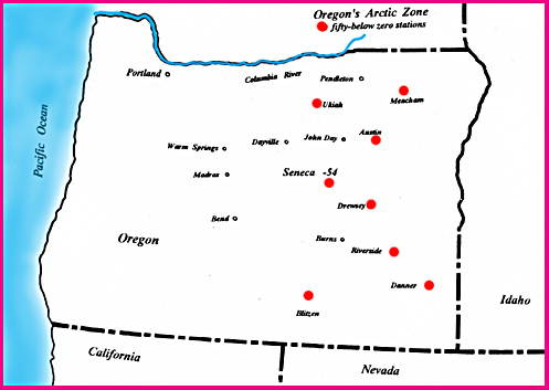
[size=small](Map from OregonPhotos.com)[/size]
Lots of interesting info about Seneca and other cold spots in Oregon:
www.oregonphotos.com/pagetwentyone-Q-1.html
www.oregonphotos.com/Seneca-recent.html
www.oregonphotos.com/Seneca-New-Millenium.html
www.oregonphotos.com/Meacham.html
www.oregonphotos.com/Oregon-hot-n-cold-records.html
cliffmass.blogspot.com/2013/08/extreme-t...n-oregon-seneca.html
www.wrcc.dri.edu/cgi-bin/cliMAIN.pl?or7675 (WRCC: Seneca, OR)
www.wrcc.dri.edu/cgi-bin/cliRECt.pl?or7675 (full table of daily records for Seneca)
These two books are also full of interesting Oregon weather info:
George H. Taylor and Raymond R. Hatton. The Oregon Weather Book: A State of Extremes. Oregon State University Press, 1999, 256 pages.
George H. Taylor and Chris Hannan. The Climate of Oregon: From Rain Forest to Desert. Oregon State University Press, 1999, 224 pages.
However, the arctic blast this time was not as severe in eastern Oregon as it was in south-central Oregon, so Seneca only got down to -28 °F, far short of the values at the coldest sites. Here is data from the NCDC for Seneca during the December cold snap:
[tt] Seneca, OR
Elev: 4660 ft Lat: 44.138° N Lon: 118.975° W
Temperature (°F) Precip
Year MM DD Max Min (in)
2013 12 1 51 26 0.00
2013 12 2 40 15 0.10
2013 12 3
2013 12 4
2013 12 5
2013 12 6
2013 12 7 6 -28 0.00
2013 12 8 10 -17 0.00
2013 12 9 30 -8 0.00
2013 12 10 26 -6 0.00
2013 12 11 35 -5 0.00
2013 12 12 35 -5 0.00
2013 12 13 40 12 0.00
[/tt]
Replied by Amar Andalkar on topic Re: COLD: Below zero F today at almost all NWAC sites!
Those temperatures in eastern Oregon (as low as -41F) look like they could be very close to all-time record low temperatures for the state.
(a belated reply which I started writing back then in December, but never completed and posted)
Most of the December 8 low temperatures in that region (east of the Cascade Range along the US 97 corridor from MacDoel, CA, through Klamath Falls north to Bend) were all-time record lows at those sites, including the -41 °F at the ODOT Horse Ridge site, the -39 °F at the Christmas Valley AgriMet site, and the -31 °F at the Medicine Lake CCSS site , in the caldera of Medicine Lake Volcano -- although records for the first two sites extend back only 10 and 15 years, with almost 30 years at Medicine Lake. The city of Lakeview (one of the highest in Oregon at 4800 ft) on the eastern edge of this region also set an all-time record low of -27 °F.
However, the all-time record low temperatures for the state of Oregon are much colder than any of those: several sites have reached -50 °F or colder, all located farther east in eastern Oregon, all in valleys surrounded by mountain ranges where cold air can sink and pool. Topped by the -54 °F recorded at Ukiah on February 9, 1933, and Seneca on February 10, 1933, the latter of which is the official state record.
[size=small](Map from OregonPhotos.com)[/size]
Lots of interesting info about Seneca and other cold spots in Oregon:
www.oregonphotos.com/pagetwentyone-Q-1.html
www.oregonphotos.com/Seneca-recent.html
www.oregonphotos.com/Seneca-New-Millenium.html
www.oregonphotos.com/Meacham.html
www.oregonphotos.com/Oregon-hot-n-cold-records.html
cliffmass.blogspot.com/2013/08/extreme-t...n-oregon-seneca.html
www.wrcc.dri.edu/cgi-bin/cliMAIN.pl?or7675 (WRCC: Seneca, OR)
www.wrcc.dri.edu/cgi-bin/cliRECt.pl?or7675 (full table of daily records for Seneca)
These two books are also full of interesting Oregon weather info:
George H. Taylor and Raymond R. Hatton. The Oregon Weather Book: A State of Extremes. Oregon State University Press, 1999, 256 pages.
George H. Taylor and Chris Hannan. The Climate of Oregon: From Rain Forest to Desert. Oregon State University Press, 1999, 224 pages.
However, the arctic blast this time was not as severe in eastern Oregon as it was in south-central Oregon, so Seneca only got down to -28 °F, far short of the values at the coldest sites. Here is data from the NCDC for Seneca during the December cold snap:
[tt] Seneca, OR
Elev: 4660 ft Lat: 44.138° N Lon: 118.975° W
Temperature (°F) Precip
Year MM DD Max Min (in)
2013 12 1 51 26 0.00
2013 12 2 40 15 0.10
2013 12 3
2013 12 4
2013 12 5
2013 12 6
2013 12 7 6 -28 0.00
2013 12 8 10 -17 0.00
2013 12 9 30 -8 0.00
2013 12 10 26 -6 0.00
2013 12 11 35 -5 0.00
2013 12 12 35 -5 0.00
2013 12 13 40 12 0.00
[/tt]
Please Log in or Create an account to join the conversation.
- Amar Andalkar
-
Topic Author
- User
-
Less
More
- Posts: 635
- Thank you received: 0
12 years 4 months ago - 12 years 4 months ago #220154
by Amar Andalkar
Replied by Amar Andalkar on topic Re: COLD: Below zero F today at almost all NWAC sites!
Well, it happened AGAIN! Another cold snap very similar in severity to that of December 7, 2013, which was the coldest in many years for the Washington and Oregon Cascades. Once again this morning, almost every single NWAC telemetry site recorded a minimum below 0 °F!
Overall, 24 out of 27 operating NWAC sites recorded minimums below 0 °F overnight (on at least one of the temperature sensors for sites with multiple temperature sensors), with 1 other site reaching 1 °F. At all of the sites, the minimum occurred right around sunrise or just prior, normally the coldest time of day (all other factors being equal), unlike on December 7 when a few higher-elevation sites had their minimums near midnight and then warmed by several degrees prior to dawn. Low temperatures this time were fairly comparable to those on December 7. The coldest sites were Mission Ridge 6730' at -15 °F, Camp Muir 10110' at -14°F, and Crystal Mountain Green Valley 6230' at -13 °F. The three sites that failed to go below zero were Lake Wenatchee 1930' at 1 °F, Hurricane Ridge 5250' at 3 °F, and Berne 2700' at 5 °F.
The current forecast predicts that temperatures tonight and tomorrow morning should be similar to today's at many of these sites, except at the higher-elevation sites where the air should be warming slightly late tonight and into tomorrow.
Note about the "-0" readings: apparently, the temperature sensors at most (all?) of these sites read in 0.1 °F increments, but are rounded to 1 °F increments for display online. Hence "-0" implies a temperature between -0.1 and -0.4 °F.
[hr][tt]Northwest Avalanche Center
Hurricane Ridge, Olympic National Park, Washington
MM/DD Hour Temp RH Wind Wind Wind Wind Hour Total Total
PST F % Min Avg Max Dir Prec Prec Snow
5250' 5250' 5250' 5250' 5250' 5250' 5250' 5250' 5250'
2 4 1100 14 75 0 4 13 94 0 0 24
2 4 1200 11 84 0 4 10 103 0 0 27
2 4 1300 11 88 0 0 5 45 0 0 24
2 4 1400 10 87 0 2 6 5 0 0 29
2 4 1500 10 87 0 0 3 2 0 0 29
2 4 1600 8 89 0 2 7 5 0 0 234
2 4 1700 7 89 0 1 4 29 0 0 30
2 4 1800 7 90 0 2 8 33 0 0 30
2 4 1900 8 90 0 6 11 83 0 0 28
2 4 2000 8 90 7 10 17 87 0 0 28
2 4 2100 7 90 7 11 15 86 0 0 29
2 4 2200 8 90 6 12 21 97 0 0 31
2 4 2300 8 89 5 10 16 94 0 0 29
2 5 0 7 89 3 7 11 87 0 0 28
2 5 100 6 88 4 8 12 89 0 0 30
2 5 200 6 88 0 7 16 64 0 0 31
2 5 300 6 88 0 2 9 30 0 0 31
2 5 400 5 88 0 4 13 15 0 0 31
2 5 500 4 87 0 4 11 34 0 0 30
2 5 600 4 87 0 7 16 52 0 0 32
2 5 700 3 87 2 7 22 46 0 0 32
2 5 800 3 86 1 8 21 64 0 0 33
2 5 900 4 86 0 8 21 66 0 0 32
2 5 1000 11 76 0 1 11 78 0 0 32
Northwest Avalanche Center
Mt Baker Ski Area, Washington
Wind gages unheated and may rime
Precipitation gage is under-reporting
MM/DD Hour Temp Temp RH RH Wind Wind Wind Wind Hour Total 24 Hr Total
PST F F % % Min Avg Max Dir Prec Prec Snow Snow
5020' 4210' 5020' 4210' 5020' 5020' 5020' 5020' 4210' 4210' 4210' 4210'
2 4 1100 11 12 79 71 1 4 8 125 .00 .00 0 79
2 4 1200 9 12 84 71 1 4 6 146 .00 .00 0 79
2 4 1300 7 13 85 70 3 6 11 93 .00 .00 0 79
2 4 1400 10 13 84 72 1 4 8 101 .00 .00 0 79
2 4 1500 10 14 87 70 1 3 6 176 .00 .00 0 79
2 4 1600 8 14 84 69 1 6 10 97 .00 .00 0 78
2 4 1700 7 11 83 69 2 5 8 134 .00 .00 1 76
2 4 1800 6 9 79 68 4 6 11 162 .00 .00 1 77
2 4 1900 5 9 78 67 5 8 13 170 .00 .00 0 77
2 4 2000 5 9 78 66 4 9 14 182 .00 .00 1 77
2 4 2100 4 8 79 68 4 7 13 165 .00 .00 1 77
2 4 2200 4 8 76 65 3 6 8 157 .00 .00 1 77
2 4 2300 3 7 76 66 4 6 9 152 .00 .00 1 77
2 5 0 3 7 75 64 4 6 8 145 .00 .00 1 76
2 5 100 3 6 75 64 4 8 12 146 .00 .00 1 77
2 5 200 2 6 74 64 4 8 13 160 .00 .00 1 77
2 5 300 2 5 71 62 4 8 14 170 .00 .00 1 77
2 5 400 1 5 71 63 5 9 18 169 .00 .00 1 77
2 5 500 0 4 72 63 6 9 15 163 .00 .00 1 77
2 5 600 0 4 70 61 5 9 15 157 .00 .00 1 77
2 5 700 -0 4 69 61 4 8 13 157 .00 .00 1 77
2 5 800 -0 4 66 56 4 9 16 162 .00 .00 1 76
2 5 900 3 6 63 54 4 9 16 167 .00 .00 1 81
2 5 1000 5 8 55 48 4 8 12 179 .00 .00 0 75
Northwest Avalanche Center
Washington Department of Transportation
Washington Pass, Washington
Wind gages unheated and may rime
Equip temp is prec gage temp
Prec gage not recording or out
MM/DD Hour Temp Temp RH RH Wind Wind Wind Equip Hour Total Total
PST F F % % Avg Max Dir Temp Prec Prec Snow
6680' 5450' 6680' 5450' 6680' 6680' 6680' 5450' 5450' 5450' 5450'
2 4 1100 5 5 83 81 1 4 36 37 0 0 52
2 4 1200 5 5 80 81 5 8 22 39 0 0 52
2 4 1300 8 8 85 80 6 8 16 40 0 0 51
2 4 1400 8 8 84 80 6 12 18 41 0 0 51
2 4 1500 6 6 86 75 8 11 8 38 0 0 51
2 4 1600 6 6 88 78 5 12 23 37 0 0 51
2 4 1700 4 4 87 83 10 16 34 34 0 0 51
2 4 1800 3 3 88 87 12 18 35 32 0 0 51
2 4 1900 3 3 88 87 14 22 37 32 0 0 51
2 4 2000 2 2 87 88 13 20 37 31 0 0 51
2 4 2100 2 2 87 87 16 21 32 31 0 0 51
2 4 2200 1 1 87 86 13 19 29 31 0 0 51
2 4 2300 0 0 88 86 12 18 31 30 0 0 51
2 5 0 -0 -0 86 86 11 17 19 30 0 0 51
2 5 100 -1 -1 86 85 11 15 18 29 0 0 51
2 5 200 -2 -2 87 85 14 23 22 27 0 0 51
2 5 300 -3 -3 86 83 13 17 8 27 0 0 52
2 5 400 -4 -4 86 85 12 18 14 25 0 0 52
2 5 500 -4 -4 85 83 12 17 15 24 0 0 51
2 5 600 -5 -5 85 82 12 17 15 23 0 0 51
2 5 700 -7 -7 85 83 12 21 21 23 0 0 51
2 5 800 -6 -6 85 82 14 19 25 23 0 0 51
2 5 900 -6 -6 86 82 13 18 11 24 0 0 51
2 5 1000 -5 -5 82 80 12 19 17 20 .04 .04 51
Northwest Avalanche Center
Freestone Inn, Mazama, Washington
Wind gages unheated and may rime
MM/DD Hour Temp RH Solar Wind Wind Wind Hour Total 24 Hr Total
PST F % W/m2 Avg Max Dir Prec Prec Snow Snow
2170' 2170' 2170' 2170' 2170' 2170' 2170' 2170' 2170' 2170'
2 4 1100 17 62 39 0 3 72 0 0 3 10
2 4 1200 19 64 50 0 5 59 0 0 0 10
2 4 1300 23 53 82 1 5 135 0 0 0 10
2 4 1400 21 54 37 1 2 153 0 0 0 10
2 4 1500 21 48 28 1 4 141 0 0 0 10
2 4 1600 19 57 10 1 2 157 0 0 0 10
2 4 1700 18 61 1 0 2 163 0 0 0 10
2 4 1800 17 65 -0 0 0 168 0 0 0 10
2 4 1900 18 70 0 0 2 160 0 0 0 10
2 4 2000 16 73 -0 0 0 0 0 0 0 10
2 4 2100 16 66 0 0 0 0 0 0 0 10
2 4 2200 13 73 -0 0 0 0 0 0 0 10
2 4 2300 11 77 0 0 0 0 0 0 0 10
2 5 0 10 79 0 0 0 0 0 0 0 10
2 5 100 8 82 0 0 0 0 0 0 0 10
2 5 200 6 84 0 0 0 0 0 0 0 10
2 5 300 8 83 0 0 0 0 0 0 0 10
2 5 400 7 83 0 0 0 0 0 0 0 9
2 5 500 2 81 0 0 0 0 0 0 0 10
2 5 600 -1 80 -0 0 0 0 0 0 0 10
2 5 700 -4 79 -0 0 0 0 0 0 0 10
2 5 800 -5 78 4 0 0 0 0 0 0 10
2 5 900 -1 80 11 0 0 0 0 0 0 10
2 5 1000 6 74 12 0 2 215 0 0 0 10
Northwest Avalanche Center
Tye Mill (5180'), Skyline (5250'), Daisy (4370') sites
Stevens Pass Ski Area, Washington
Wind gages unheated and may rime
Data file revised to include Daisy data 29 Jan 2014
MM/DD Hour Temp Temp Wind Wind Wind Hour Total 24 Hr Total
PST F F Avg Max Dir Prec Prec Snow Snow
5180' 5250' 5180' 5180' 5180' 4370' 4370' 4370' 5250'
2 4 1100 9 8 0 1 89 0 0 2 79
2 4 1200 9 9 0 2 101 0 0 3 84
2 4 1300 8 8 0 2 91 0 0 3 84
2 4 1400 8 9 0 2 84 0 0 2 84
2 4 1500 6 7 0 2 86 0 0 3 84
2 4 1600 5 5 0 2 65 0 0 3 85
2 4 1700 3 2 0 0 71 0 0 3 85
2 4 1800 2 1 0 0 61 0 0 3 85
2 4 1900 1 1 0 0 51 0 0 3 85
2 4 2000 1 1 0 0 70 0 0 3 85
2 4 2100 -0 1 0 0 76 0 0 3 85
2 4 2200 -1 -1 0 0 50 0 0 3 85
2 4 2300 -1 -0 0 0 64 0 0 3 85
2 5 0 -1 -1 0 0 86 0 0 3 85
2 5 100 -2 -1 0 0 74 0 0 3 85
2 5 200 -3 -2 0 0 62 0 0 3 84
2 5 300 -4 -3 0 0 54 0 0 3 84
2 5 400 -5 -4 0 0 58 0 0 2 84
2 5 500 -6 -5 0 0 50 0 0 2 84
2 5 600 -6 -6 0 0 53 0 0 0 84
2 5 700 -7 -6 0 0 44 0 0 0 84
2 5 800 -6 -7 0 0 53 0 0 0 84
2 5 900 -1 -6 0 2 34 0 0 0 84
2 5 1000 2 -6 0 2 38 0 0 0 84
Northwest Avalanche Center
Stevens Pass Ski Area Brooks Chair (4850')
Washington Department of Transportation Schmidt Haus (3950')
Stevens Pass, Washington
MM/DD Hour Temp Temp RH RH Wind Wind Wind Hour Total 24 Hr Total Press
PST F F % % Avg Max Dir Prec Prec Snow Snow mb
4850' 3950' 4850' 3950' 4850' 4850' 4850' 3950' 3950' 3950' 3950' 3950'
2 4 1100 7 11 86 84 9 15 25 0 0 1 62 1018
2 4 1200 7 11 87 81 10 19 21 0 0 1 62 1019
2 4 1300 7 10 86 83 10 18 21 0 0 1 62 1019
2 4 1400 7 11 86 81 7 13 25 0 0 1 62 1018
2 4 1500 7 10 86 83 8 17 22 0 0 1 62 1018
2 4 1600 5 9 86 81 8 13 40 0 0 1 62 1019
2 4 1700 4 8 87 82 7 13 43 0 0 0 62 1019
2 4 1800 3 8 86 82 8 15 44 0 0 1 62 1019
2 4 1900 3 8 87 81 7 13 46 0 0 0 62 1020
2 4 2000 3 8 86 82 7 12 43 0 0 0 62 1020
2 4 2100 3 7 86 81 8 15 47 0 0 0 62 1020
2 4 2200 2 7 86 82 7 14 50 0 0 1 62 1020
2 4 2300 2 7 86 82 7 14 50 0 0 1 62 1021
2 5 0 2 6 86 81 7 14 47 0 0 1 61 1021
2 5 100 1 6 85 81 7 14 48 0 0 1 61 1022
2 5 200 0 5 85 78 8 16 48 0 0 1 61 1022
2 5 300 -0 4 84 80 9 16 45 0 0 1 61 1021
2 5 400 -2 3 84 80 8 16 48 0 0 1 61 1022
2 5 500 -2 3 84 78 9 17 48 0 0 1 61 1022
2 5 600 -3
Please Log in or Create an account to join the conversation.