- Posts: 26
- Thank you received: 0
Extreme Avalanche Hazard, plus 4-6 ft of New Snow
- Tony_Bentley
-

- User
-

Less
More
14 years 3 months ago #204047
by Tony_Bentley
Replied by Tony_Bentley on topic Re: Extreme Avalanche Hazard, plus 4-6 ft of New Snow
Anyone want to form a lynch mob for those who post trip reports today and tomorrow? ")
Please Log in or Create an account to join the conversation.
- Amar Andalkar
-
Topic Author
- User
-
Less
More
- Posts: 635
- Thank you received: 0
14 years 3 months ago #204090
by Amar Andalkar
Replied by Amar Andalkar on topic Re: Extreme Avalanche Hazard, plus 4-6 ft of New Snow
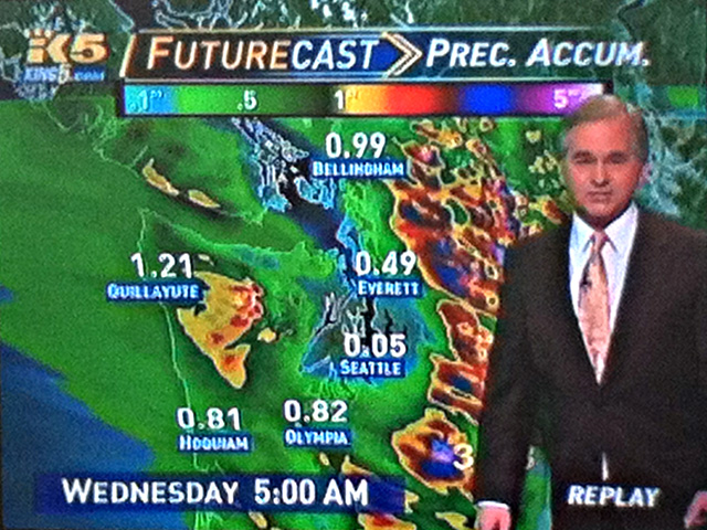
Interesting to see that KING-5 TV weather has been using and showing output from the UW model frequently over recent months. Here's a screen shot of Jim Guy explaining the rain shadow over Seattle during this storm, with precip amounts and graphics derived from the UW model:
As long as they ski in reasonable places that are safe even during extreme avy danger (the closed Summit West ski area, certain logging road tours, etc.), no lynch mob is needed. Not sure why anyone would want to ski in today's conditions though.
And by tomorrow, the avalanche hazard drops substantially given significant cooling and somewhat decreasing precipitation rates. With deep powder accumulating, people are certain to be out touring in many places, probably (unfortunately) including in unsafe areas and aspects. Some of our patterns of behavior (as a whole for the community of backcountry skiers and boarders) will clearly persist despite recent tragedies.
Anyone want to form a lynch mob for those who post trip reports today and tomorrow?
As long as they ski in reasonable places that are safe even during extreme avy danger (the closed Summit West ski area, certain logging road tours, etc.), no lynch mob is needed. Not sure why anyone would want to ski in today's conditions though.
And by tomorrow, the avalanche hazard drops substantially given significant cooling and somewhat decreasing precipitation rates. With deep powder accumulating, people are certain to be out touring in many places, probably (unfortunately) including in unsafe areas and aspects. Some of our patterns of behavior (as a whole for the community of backcountry skiers and boarders) will clearly persist despite recent tragedies.
| Danger Rose for Tuesday: http://www.nwac.us/dangerrose/preview/2719/ | Danger Rose for Wednesday: http://www.nwac.us/dangerrose/preview/2720/ |
Please Log in or Create an account to join the conversation.
- Dr. Telemark
-
- User
-
Less
More
- Posts: 6
- Thank you received: 0
14 years 3 months ago #204097
by Dr. Telemark
Replied by Dr. Telemark on topic Re: Extreme Avalanche Hazard, plus 4-6 ft of New Snow
I was wondering if a thread like this was going to come up today after looking at the entire west side of the Cascades looking nearly entire black on the danger roses. I think this is the worst forecast I have seen.
Still thinking we could work on some public service announcement to remind/teach others of how to stay alive in the winter.
Still thinking we could work on some public service announcement to remind/teach others of how to stay alive in the winter.
Please Log in or Create an account to join the conversation.
- Tony_Bentley
-
- User
-
Less
More
- Posts: 26
- Thank you received: 0
14 years 3 months ago #204098
by Tony_Bentley
Replied by Tony_Bentley on topic Re: Extreme Avalanche Hazard, plus 4-6 ft of New Snow
Sounds like the same conditions as March 1, 1910.
Please Log in or Create an account to join the conversation.
- Alan Brunelle
-
- User
-
Less
More
- Posts: 260
- Thank you received: 0
14 years 3 months ago #204105
by Alan Brunelle
Replied by Alan Brunelle on topic Re: Extreme Avalanche Hazard, plus 4-6 ft of New Snow
You were correct on this call. This ain't no pineapple express. Those Northwesterlies driving across the area is very apparent in the radar. Also, the snow level stayed just below 4K ft. for quite a lot longer than the official forecasters predicted, with Stevens making the change to rain later in the afternoon. More importantly the snow levels have already dropped in advance of the cold front passage and it appears that the snow is starting to really pile up at Stevens Pass.
While I agree that the fetch from beyond the dateline looked similar to a pineapple express, it seemed clear to me that its origins were much father north of Hawaii than typical for that pattern.
A 2-3,000ft error in predicted snow line prediction would seem to have a large impact in the forecast impact on river levels and avalanche, etc.
Could the official forecasters not see the nuances in the actual situation "the forest" for the "trees" or in other words the models and historical repetition?
I may be wrong, but after living here for over 12 years I have noticed that pineapple expresses seem to be more of a late fall early winter phenomenon. Often stoked by the tail end of the west Pacific tropical season. The other thing I have noticed is that late winter and early spring here seems to display a snow line that is incredibly resistant to rapid rises with the typical storm of the season. While the lower atmosphere is beginning to warm with longer daylight, I think the upper atmosphere is more resistant, and after the long winter, there is still a large supply of cold upper air to the north and continental. I think there is no surprise that the snowpack at Stevens and probably Baker and most all other areas in WA state are typically at their deepest on the last day they operate in April. In fact for several years in a row at Stevens I remember taking my last lift served run down an empty showcase in partial sun and snow falling into cold air, yet still feeling the heat of the sun.
What I see tonight is that Stevens is getting significant dumpage on a lowering snow level. All that from a fetch of moisture funneling down from either side of Vancouver Island with no apparent back end yet in site.
My guess is that the official forecasters will realize that they need to revise their snow accumulation forecast upward still for this segment of what appears to be an epic week of snowfall for the Cascades. Baker never switched to rain and will likely get another huge dump.
Alan
Please Log in or Create an account to join the conversation.
- cchapin
-
- User
-
Less
More
- Posts: 89
- Thank you received: 0
14 years 3 months ago #204106
by cchapin
Replied by cchapin on topic Re: Extreme Avalanche Hazard, plus 4-6 ft of New Snow
The 24 hour telemetry for Snoqualmie is pretty crazy - 63 mph gust recorded today and almost 4.5 inches of precip (mostly rain of course). Off the hook!
Please Log in or Create an account to join the conversation.