- Posts: 635
- Thank you received: 0
Extreme Avalanche Hazard, plus 4-6 ft of New Snow
- Amar Andalkar
-
 Topic Author
- User
-

Less
More
14 years 3 months ago #204067
by Amar Andalkar
Extreme Avalanche Hazard, plus 4-6 ft of New Snow was created by Amar Andalkar
The storm system coming in tonight through Tuesday-Wednesday looks really interesting. First of all, hope everyone stays safe during the avalanche warning! See
www.nwac.us/forecast/avalanche/view/
(Monday's archived forecast is at
www.nwac.us/archive/sabsea_2012-02-20-1449.html
). Danger Rose for Tuesday:
http://www.nwac.us/dangerrose/preview/2714/
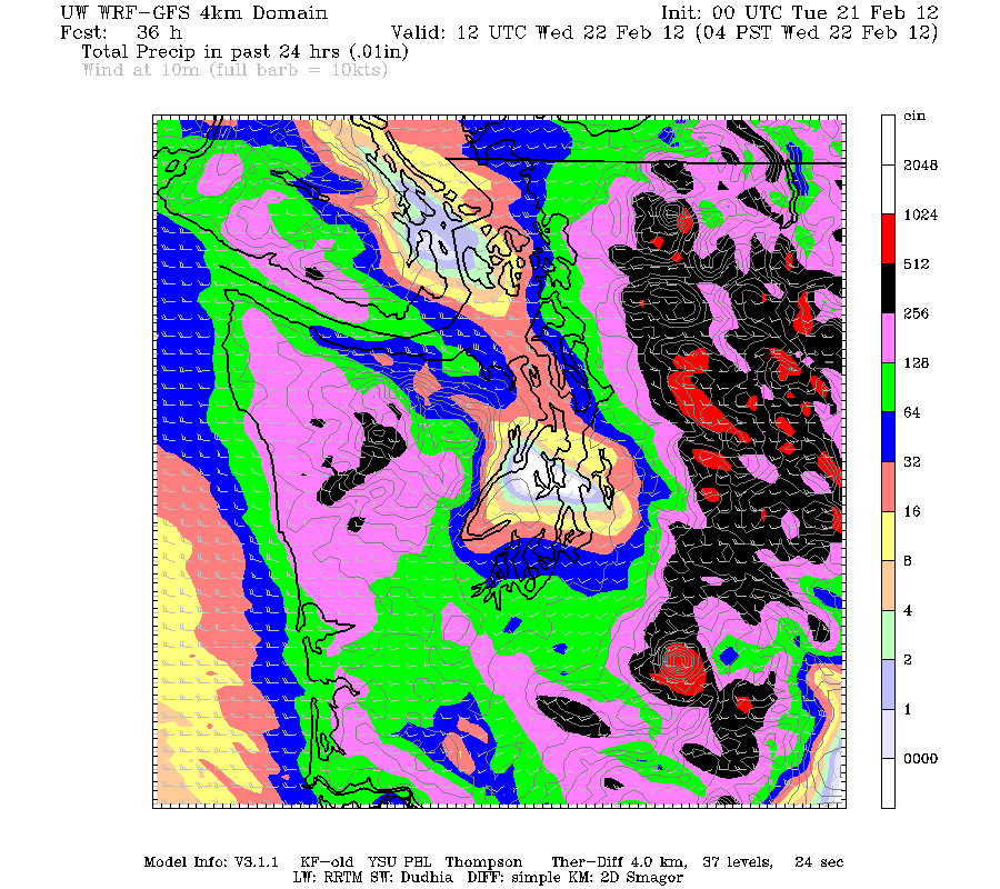
Obviously this system is bringing a lot of precipitation, up to perhaps 5-10" in many parts of the WA Cascades over a 48 hour period, but the UW weather model is predicting a strong rain shadow for the central Puget Sound (along an axis roughly from Bainbridge Island to Seattle). After some initial rainfall early tonight, this area is predicted to be almost completely dry over the next 48 hours, the driest spot in western Washington:
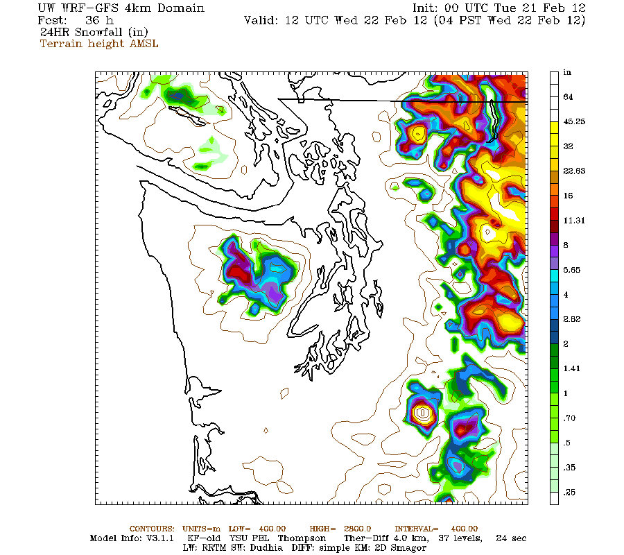
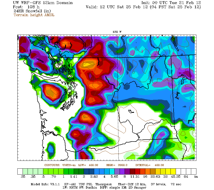
However, this is not going to be a Pineapple Express at all, the flow is really quite westerly, not southwesterly or southerly (as the predicted location of the Olympic rain shadow above shows). So this should produce HUGE snowfall above 6000 ft in the north-central Cascades and on Rainier, perhaps 3-5 ft of snow by 4am Wednesday:
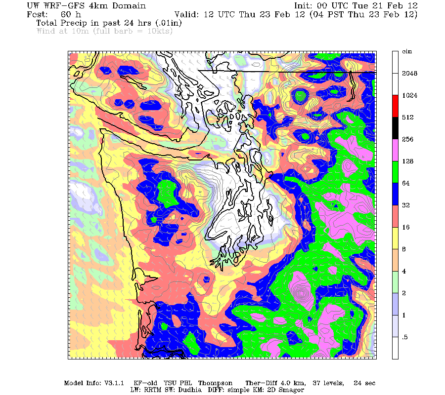
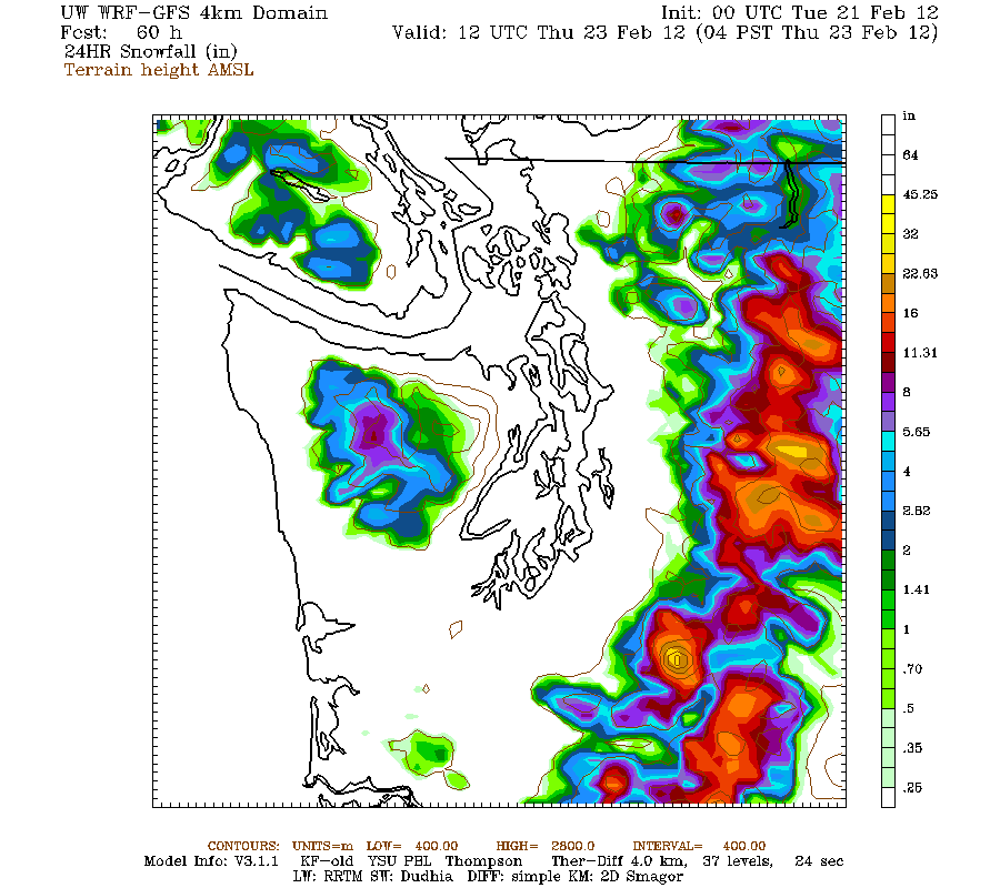
Snow levels should drop throughout Wednesday down to about 2000 ft overnight, producing a widespread 1-2 ft of snowfall over much of the WA Cascades by 4am Thursday:
And models are hinting at a chance of lowland snow by Friday, especially for NW WA and SW BC, along with another 1-2 ft in the Cascades -- but that's 4-5 days out, so the models could be entirely wrong about that:
http://www.nwac.us/dangerrose/preview/2714/
Obviously this system is bringing a lot of precipitation, up to perhaps 5-10" in many parts of the WA Cascades over a 48 hour period, but the UW weather model is predicting a strong rain shadow for the central Puget Sound (along an axis roughly from Bainbridge Island to Seattle). After some initial rainfall early tonight, this area is predicted to be almost completely dry over the next 48 hours, the driest spot in western Washington:
However, this is not going to be a Pineapple Express at all, the flow is really quite westerly, not southwesterly or southerly (as the predicted location of the Olympic rain shadow above shows). So this should produce HUGE snowfall above 6000 ft in the north-central Cascades and on Rainier, perhaps 3-5 ft of snow by 4am Wednesday:
Snow levels should drop throughout Wednesday down to about 2000 ft overnight, producing a widespread 1-2 ft of snowfall over much of the WA Cascades by 4am Thursday:
And models are hinting at a chance of lowland snow by Friday, especially for NW WA and SW BC, along with another 1-2 ft in the Cascades -- but that's 4-5 days out, so the models could be entirely wrong about that:
Please Log in or Create an account to join the conversation.
- FreeBird
-
- User
-
Less
More
- Posts: 77
- Thank you received: 0
14 years 3 months ago #204068
by FreeBird

Replied by FreeBird on topic Re: Extreme Avalanche Hazard, plus 4-6 ft of New Snow
Please Log in or Create an account to join the conversation.
- ryanl
-
- User
-
Less
More
- Posts: 48
- Thank you received: 0
14 years 3 months ago #204072
by ryanl
Replied by ryanl on topic Re: Extreme Avalanche Hazard, plus 4-6 ft of New Snow
This is great Amar. Thanks for taking to the time to post and explain.
Please Log in or Create an account to join the conversation.
- David_Britton
-
- User
-
Less
More
- Posts: 12
- Thank you received: 0
14 years 3 months ago #204079
by David_Britton
Replied by David_Britton on topic Re: Extreme Avalanche Hazard, plus 4-6 ft of New Snow
You have this one pegged Amar! Thanks for the research.
Please Log in or Create an account to join the conversation.
- Andrew Carey
-

- User
-
Less
More
- Posts: 914
- Thank you received: 0
14 years 3 months ago #204082
by Andrew Carey
Replied by Andrew Carey on topic Re: Extreme Avalanche Hazard, plus 4-6 ft of New Snow
Ditto on the thanks! NWS eliminated its text + graphics forecast, which I used all the time and Cliff Mass changed his graphics so they blow up on my iMac, so I guess I'd better go back to take a tutorial to learn how to extract those graphics again by myself! We live right at that topographical inflection that seems to initiate the heavy orographic pptn and the lower level at which it snows commonly (2000 ft asl).
Please Log in or Create an account to join the conversation.
- mick_scott
-
- User
-
Less
More
- Posts: 14
- Thank you received: 0
14 years 3 months ago #204087
by mick_scott
Replied by mick_scott on topic Re: Extreme Avalanche Hazard, plus 4-6 ft of New Snow
Thanks Amar - Great day to scrape the moss off my roof.
Please Log in or Create an account to join the conversation.