- Posts: 260
- Thank you received: 0
Extreme Avalanche Hazard, plus 4-6 ft of New Snow
- Alan Brunelle
-

- User
-

Less
More
14 years 3 months ago #204107
by Alan Brunelle
Replied by Alan Brunelle on topic Re: Extreme Avalanche Hazard, plus 4-6 ft of New Snow
Just to add to my point that the NWS scientific forecasters fail to look out the window sometimes. The 8:45PM update continues to state that the snow levels are at 6K ft. and will remain high until frontal passage tomorrow morning.
In addition, NWS is "expecting snow levels to drop below pass levels by tomorrow afternoon". Hmm. Well Stevens is clearly all snow at 4K, and now even Snoqualmie is mixed snow/rain at 3K.
Alan
In addition, NWS is "expecting snow levels to drop below pass levels by tomorrow afternoon". Hmm. Well Stevens is clearly all snow at 4K, and now even Snoqualmie is mixed snow/rain at 3K.
Alan
Please Log in or Create an account to join the conversation.
- Amar Andalkar
-
Topic Author
- User
-
Less
More
- Posts: 635
- Thank you received: 0
14 years 3 months ago #204108
by Amar Andalkar
Replied by Amar Andalkar on topic Re: Extreme Avalanche Hazard, plus 4-6 ft of New Snow
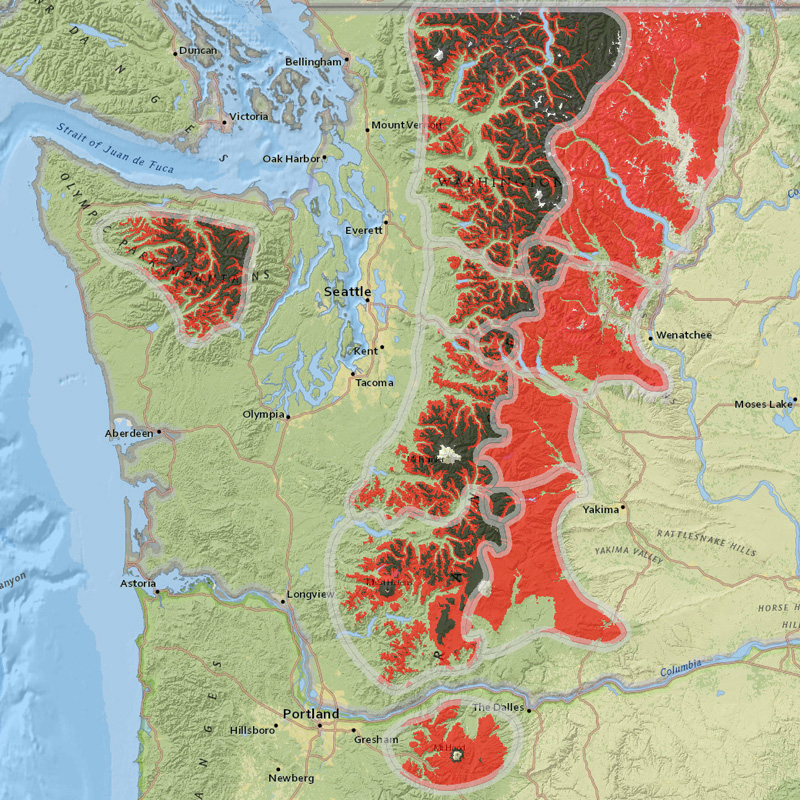
Decided to check out how the NWAC's new (perhaps controversial?)
GIS Danger Rose Display
looks on a day with an "extreme danger" bullseye for most zones:
Please Log in or Create an account to join the conversation.
- ~Link~
-
- User
-
Less
More
- Posts: 124
- Thank you received: 0
14 years 3 months ago #204110
by ~Link~
Replied by ~Link~ on topic Re: Extreme Avalanche Hazard, plus 4-6 ft of New Snow
Massive rain below 6k, and massive dumps just above. Winds and teetering temps. That should make for some interesting field observations. Thanks for sharing, Amar.
Be safe out there.
Be safe out there.
Please Log in or Create an account to join the conversation.
- Amar Andalkar
-
Topic Author
- User
-
Less
More
- Posts: 635
- Thank you received: 0
14 years 3 months ago #204115
by Amar Andalkar
Replied by Amar Andalkar on topic Re: Extreme Avalanche Hazard, plus 4-6 ft of New Snow
Not sure why the forecasts and models were so far off on the freezing level / snow level during this event, as even the Tuesday morning UW model run showed the freezing level peaking at 6000-7000 ft along the entire crest of the WA Cascades between 1pm and 4pm on Tuesday afternoon:
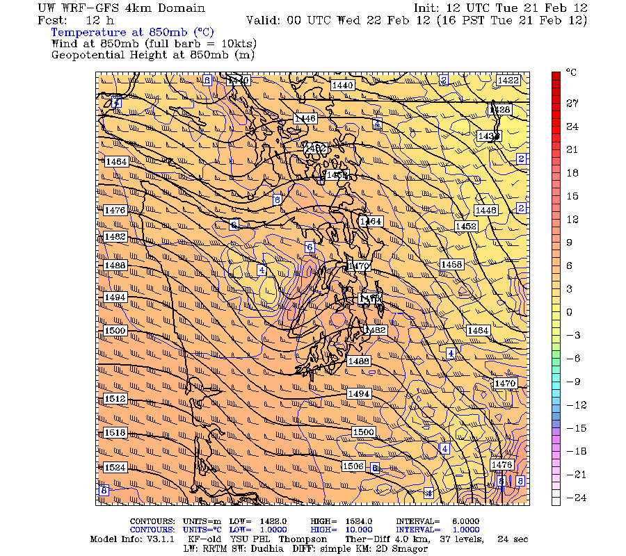
This was defintely a bit higher than it actually turned out, especially so at Mount Baker, which remained below 33 °F all day at 4200 ft and picked up over 15" of new snow during a 24 hour period on Tuesday. Freezing levels farther south at Mount Hood did easily exceed 7000 ft for most of Tuesday afternoon according to NWAC telemetry.
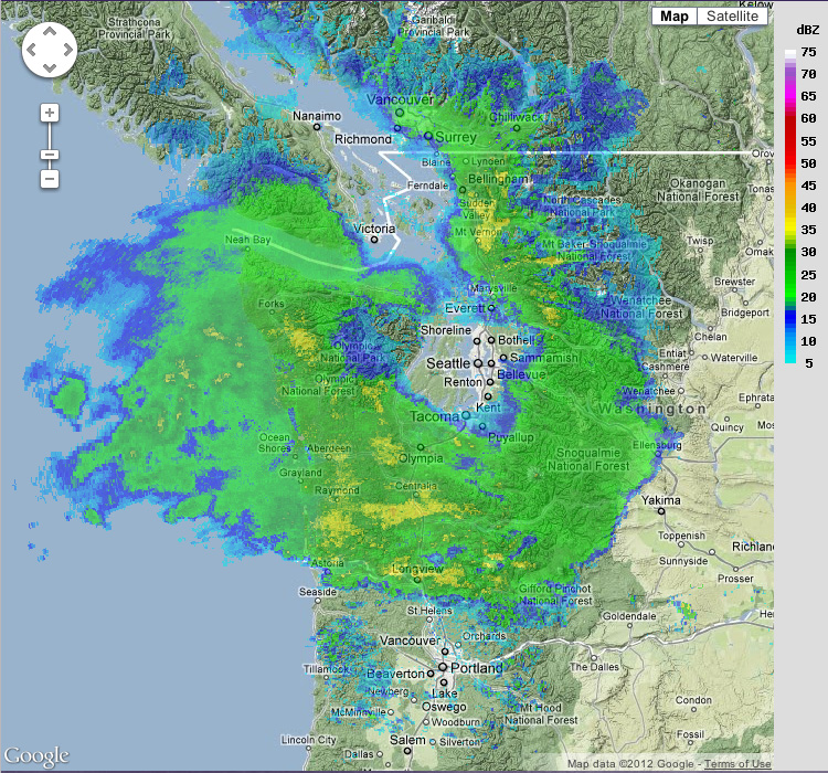
But other predictions from the UW model, such as the strong rain shadow centered along an axis roughly from Bainbridge Island to Seattle, were extremely accurate. Here's a radar image from the UW Northwest Radar Loop (which combines the data from several radar locations) taken just after midnight on Wednesday, clearly showing the rain shadow surrounded by intense precipitation:
And here's the output of the UW Seattle RainWatch system (which uses the Camano Island NWS radar to calculate precipitation totals) for a 24 hour period on Tuesday, showing precip totals under 0.1" in the rain shadow and over 6" in parts of the Cascades:
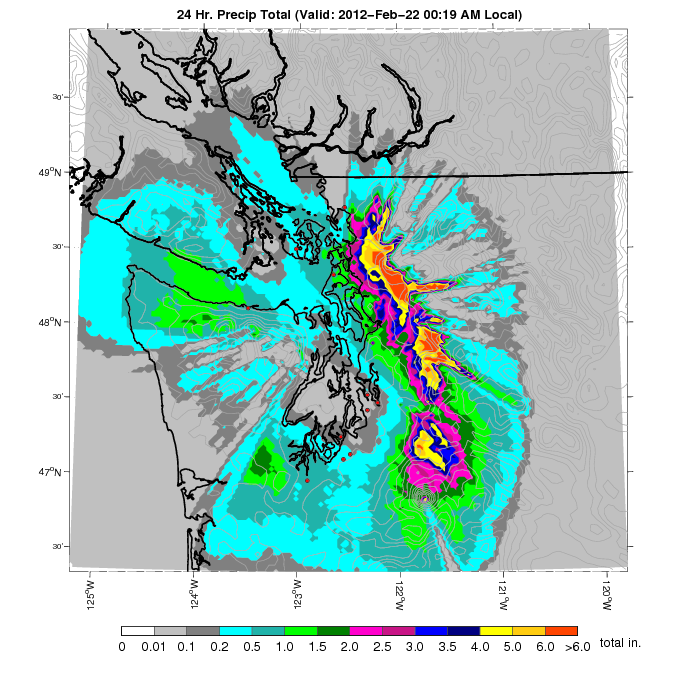
The NWAC telemetry sites at Snoqualmie Pass and Alpental each received 4.9 during that 24 hour period on Tuesday, with 4.6" at Paradise on Mount Rainier.
This was defintely a bit higher than it actually turned out, especially so at Mount Baker, which remained below 33 °F all day at 4200 ft and picked up over 15" of new snow during a 24 hour period on Tuesday. Freezing levels farther south at Mount Hood did easily exceed 7000 ft for most of Tuesday afternoon according to NWAC telemetry.
But other predictions from the UW model, such as the strong rain shadow centered along an axis roughly from Bainbridge Island to Seattle, were extremely accurate. Here's a radar image from the UW Northwest Radar Loop (which combines the data from several radar locations) taken just after midnight on Wednesday, clearly showing the rain shadow surrounded by intense precipitation:
And here's the output of the UW Seattle RainWatch system (which uses the Camano Island NWS radar to calculate precipitation totals) for a 24 hour period on Tuesday, showing precip totals under 0.1" in the rain shadow and over 6" in parts of the Cascades:
The NWAC telemetry sites at Snoqualmie Pass and Alpental each received 4.9 during that 24 hour period on Tuesday, with 4.6" at Paradise on Mount Rainier.
Please Log in or Create an account to join the conversation.
- Amar Andalkar
-
Topic Author
- User
-
Less
More
- Posts: 635
- Thank you received: 0
14 years 3 months ago - 14 years 3 months ago #204116
by Amar Andalkar
Replied by Amar Andalkar on topic Re: Extreme Avalanche Hazard, plus 4-6 ft of New Snow
In addition to all of the other interesting details of this storm, it has produced an extended period of VERY high winds well over 100 mph on Tuesday and overnight into Wednesday, at elevations above about 7000 ft from roughly Mission Ridge in central Washington, south to Mount Bachelor in central Oregon.
In fact, it appears that a new record has been set: the 161 mph and 163 mph gusts near midnight and 3am on Wednesday at the 7300 ft top of Cascade Express at Mt Hood Meadows are the highest winds recorded at any NWAC telemetry site over the full period of data (as far as I can find), exceeding the 155 mph gust at Camp Muir on 12Feb2011 (see this post from last year). However, average and minimum wind speeds at Muir were much higher during the February 2011 storm (average 132 mph, minimum 107 mph) than during tonight's storm on Mount Hood. Unfortunately, by 8am, the anemometer at the top of Cascade Express had rimed over and stopped spinning, leaving the wind speed fixed at zero afterward. NOTE: The NWAC site at the top of Cascade Express went online on 29Jan2011, but it has still not been properly linked from the NWAC website. The raw data from this site is available in the NWAC data directory, www.nwac.us/data/ .
Winds at the 7000 ft top of Magic Mile at Timberline on the south side of Mt Hood reached 123 mph earlier on Tuesday, while the 9000 ft summit of Mt Bachelor recorded a 139 mph gust Tuesday morning (this is not NWAC data, but is provided on the ski resort's website at www.mtbachelor.com/cams/24.html ). Mission Ridge and Camp Muir each had many hours with wind gusts exceeding 100 mph on Tuesday and into Wednesday. The anemometer at Muir had also rimed over and stopped spinning by 3am however, as air temperatures dropped in the wake of the cold frontal passage.
[tt]
Northwest Weather and Avalanche Center
Mission Ridge Ski Area, Washington
MM/DD Hour Temp Temp Temp RH RH Wind Wind Wind Hour Total 24 Hr Total
PST F F F % % Avg Max Dir Prec. Prec. Snow Snow
6730' 5160' 4610' 6730' 5160' 6730' 6730' 6730' 5160' 5160' 5160' 5160'
2 21 200 27 33 35 100 95 44 75 299 0 .01 0 40
2 21 300 28 35 38 100 93 46 88 304 0 .01 0 40
2 21 400 29 37 39 100 92 47 79 307 0 .01 0 40
2 21 500 29 37 40 100 93 48 74 306 0 0 0 40
2 21 600 29 38 39 100 90 49 84 305 0 0 0 40
2 21 700 29 38 39 100 89 51 81 306 0 0 0 40
2 21 800 29 38 39 100 90 52 83 304 0 0 0 39
2 21 900 29 37 39 100 90 57 91 304 0 0 0 39
2 21 1000 29 37 39 100 88 57 89 302 0 0 0 39
2 21 1100 29 37 39 100 88 58 99 301 0 0 0 39
2 21 1200 30 38 40 100 90 58 97 300 0 0 0 39
2 21 1300 32 38 41 100 93 66 105 299 .01 .01 0 39
2 21 1400 31 37 40 100 99 66 108 298 .1 .11 0 39
2 21 1500 31 36 39 100 100 64 99 295 .1 .21 0 39
2 21 1600 30 35 38 100 100 61 98 295 .04 .25 0 39
2 21 1700 29 34 37 100 100 58 93 294 .03 .28 0 38
2 21 1800 28 33 36 100 100 57 84 296 .01 .29 0 38
2 21 1900 28 33 36 100 100 56 83 296 .01 .3 0 38
2 21 2000 27 33 35 100 100 60 94 297 .02 .32 0 38
2 21 2100 27 33 35 100 100 64 103 295 .01 .33 0 38
2 21 2200 28 33 36 100 100 63 95 295 .04 .37 0 39
2 21 2300 28 34 37 100 100 63 97 296 .04 .41 0 39
2 22 0 28 33 37 100 100 58 87 295 .03 .44 0 39
2 22 100 28 33 36 100 100 58 91 293 .04 .48 0 39
2 22 200 27 32 35 100 100 67 90 287 .05 .53 0 38
2 22 300 26 32 34 100 100 63 90 287 .1 .63 0 38
2 22 400 26 32 34 100 100 69 105 288 .11 .74 2 41
2 22 500 26 32 34 100 100 69 102 286 .12 .86 2 41
2 22 600 26 32 34 100 100 66 107 286 .15 1.01 3 128
2 22 700 26 31 34 100 100 61 101 293 .1 1.11 4 43
2 22 800 26 31 34 100 100 54 100 295 .05 1.16 4 42
Northwest Weather and Avalanche Center
Camp Muir, Mt Rainier National Park, Washington
Wind gages unheated and may rime
MM/DD Hour Temp RH Wind Wind Wind Wind Solar
PST F % Min Avg Max Dir W/m2
10110' 10110' 10110' 10110' 10110' 10110' 10110'
2 21 200 22 97 8 29 52 236 0
2 21 300 23 97 6 27 46 228 0
2 21 400 23 98 9 31 47 222 0
2 21 500 24 98 9 36 61 230 0
2 21 600 23 98 13 43 64 229 0
2 21 700 24 98 32 53 81 235 0
2 21 800 23 97 18 52 72 232 12
2 21 900 23 97 33 53 72 206 47
2 21 1000 25 98 17 50 80 224 65
2 21 1100 25 98 48 77 105 241 85
2 21 1200 25 98 56 84 105 269 82 ---- Wind direction rimes over
2 21 1300 24 98 60 79 103 269 74 and stays fixed afterwards
2 21 1400 23 98 47 81 105 269 79
2 21 1500 21 97 22 57 81 269 55
2 21 1600 24 98 28 61 96 269 42
2 21 1700 24 97 22 58 80 269 20
2 21 1800 22 96 22 58 78 269 4
2 21 1900 23 98 26 75 95 269 0
2 21 2000 20 97 57 80 104 269 0
2 21 2100 21 97 49 81 104 269 0
2 21 2200 22 98 62 82 108 269 0
2 21 2300 22 97 66 85 100 269 0
2 22 0 21 97 69 87 104 269 0
2 22 100 21 97 57 84 95 269 0
2 22 200 21 97 66 84 99 269 0
2 22 300 20 97 0 35 103 269 0 ---- Anemometer rimes over
2 22 400 18 96 0 0 0 269 0 and stops spinning
2 22 500 16 95 0 0 0 269 0
2 22 600 16 95 0 0 0 269 0
2 22 700 15 95 0 0 0 269 0
2 22 800 13 94 0 0 0 269 10
2 22 900 2 90 0 0 0 269 82 ---- Temperature plummeting
2 22 1000 3 90 0 0 0 269 395 since the early AM hours
Northwest Weather and Avalanche Center Northwest Weather and Avalanche Center
Top of Cascade Express, Mt Hood Meadows Ski Resort Top of The Magic Mile chair, Timberline, Oregon
Wind gages not heating and may rime
MM/DD Hour Temp RH Wind Wind Wind Wind MM/DD Hour Temp RH Wind Wind Wind Wind
PST F % Min Avg Max Dir PST F % Min Avg Max Dir
7300' 7300' 7300 7300' 7300' 7300' 7000' 7000' 7000' 7000' 7000' 7000'
2 21 200 28 98 27 49 66 268 2 21 200 29 100 34 50 62 300
2 21 300 29 98 25 46 71 300 2 21 300 29 100 30 52 75 291
2 21 400 29 99 28 45 70 300 2 21 400 30 100 25 50 82 288
2 21 500 30 100 26 53 78 310 2 21 500 30 100 25 56 85 297
2 21 600 30 100 35 58 83 283 2 21 600 30 100 22 58 93 309
2 21 700 30 100 32 59 89 290 2 21 700 30 100 12 58 92 310
2 21 800 30 100 38 68 96 271 2 21 800 30 100 1 59 96 316
2 21 900 29 100 35 65 98 304 2 21 900 30 100 1 58 110 323
2 21 1000 31 100 45 73 110 280 2 21 1000 31 100 17 65 113 323
2 21 1100 31 100 36 74 120 262 2 21 1100 32 100 12 59 116 322
2 21 1200 32 100 42 78 117 24 2 21 1200 32 100 16 66 117 310
2 21 1300 33 100 38 77 122 324 2 21 1300 32 100 19 66 123 300
2 21 1400 32 98 40 76 107 331 2 21 1400 33 100 44 57 80 279
2 21 1500 32 100 46 79 132 246 2 21 1500 33 100 44 61 81 274
2 21 1600 33 100 40 87 148 309 2 21 1600 33 100 50 65 86 270
2 21 1700 32 100 49 85 135 260 2 21 1700 33 100 48 63 82 283
2 21 1800 32 100 35 79 115 334 2 21 1800 33 100 47 59 79 278
2 21 1900 32 100 44 77 118 279 2 21 1900 32 100 43 58 76 277
2 21 2000 32 100 46 81 118 350 2 21 2000 32 100 43 58 76 281
2 21 2100 32 100 47 84 121 285 2 21 2100 33 100 45 58 73 292
2 21 2200 33 100 46 85 126 71 2 21 2200 33 100 46 59 72 276
2 21 2300 33 100 53 89 139 140 2 21 2300 33 100 48 62 78 286
2 22 0 32 100 56 98 161 49 2 22 0 33 100 47 63 82 282
2 22 100 33 100 50 99 150 223 2 22 100 33 100 44 61 82 272
2 22 200 32 100 34 101 152 305 2 22 200 32 100 51 66 84 274
2 22 300 31 98 26 100 163 276 2 22 300 32 100 45 59 81 272
2 22 400 31 100 44 85 141 235 2 22 400 32 100 34 54 74 270
2 22 500 30 100 40 75 112 137 2 22 500 32 100 29 38 49 271
2 22 600 29 99 39 81 131 17 2 22 600 30 100 24 34 48 275
2 22 700 27 98 16 69 116 319
2 22 800 26 97 0 18 98 124 ---- Anemometer rimes over
2 22 900 26 97 0 0 0 121 and stops spinning
2 22 1000 26 97 0 0 1 110
Mt Bachelor Ski Resort, Oregon
Year Month Date Time Base Pmx Pmx Pmx Pmx Pmx Smt Smt Smt Smt Smt
Temp Temp RH Wind Wind Wind Temp RH Wind Wind Wind
6300' 7800' 7800' Avg Max Dir 9000' 9000' Avg Max Dir
2012 2 21 100 30.5 27.6 96 5 7 339 22.5 97 74 81 161
2012 2 21 200 30.4 27.7 96 2 5 347 22.8 98 69 88 158
2012 2 21 300 30.6 27.6 96 0 0 342 22.5 97 75 112 205
2012 2 21 400 30.6 27.8 96 0 0 345 22.9 98 91 106 296
2012 2 21 500 31.3 28.6 97 0 0 341 24.4 98 95 139 296
2012 2 21 600 31.6 29.3 97 0 0 342 25.2 99 94 114 296
2012 2 21 700 31.8 29.5 97 16 22 342 25 98 90 117 296
2012 2 21 800 31.8 29.4 97 11 13 341 25.2 99 68 111 296
2012 2 21 900 31.8 29.5 97 6 9 341 25.6 99 43 85 295
2012 2 21 1000 31.8 29.7 97 7 11 342 25.9 99 97 120 298
2012 2 21 1100 31.8 30.7 97 5 8 342 26.3 99 52 85 300
2012 2 21 1200 31.8 31.4 97 4 6 342 27.4 99 80 103 303
2012 2 21 1300 31.8 32.3 98 2 4 341 28.1 99 80 99 308
2012 2 21 1400 32.4 32.4 98 0 0 342 28.3 100 65 108 314
2012 2 21 1500 33.8 32.6 98 0 0 340 28.4 100 61 100 319
2012 2 21 1600 35.2 32.6 98 0 0 342 28.6 100 55 86 322
2012 2 21 1700 35.5 32.7 98 0 0 341 28.8 100 64 91 326
2012 2 21 1800 35.5 32.7 98 0 0 340 28.6 100 39 61 329
2012 2 21 1900 35.9 32.8 98 0 0 342 28.9 100 38 58 333
2012 2 21 2000 36.3 32.8 98 0 0 342 29.2 100 41 66 340
2012 2 21 2100 36 32.8 98 0 0 342 29.1 100 49 71 297
2012 2 21 2200 35.8 32.8 98 0 0 342 28.8 100 13 42 264
2012 2 21 2300 35.8 32.7 98 0 0 341 28.7 100 7 13 297
2012 2 21 2400 35.8 32.7 98 0 0 340 28.6 100 43 0 -999 ---- Data is suspect
2012 2 22 100 35.8 32.7 98 0 0 338 28.4 100 30 0 -999 for these hours
2012 2 22 200 35.2 32.6 98 0 0 342 27.7 100 25 0 -999
2012 2 22 300 34.4 32.3 98 0 0 343 26.7 100 11 0 -999
2012 2 22 400 33.6 31.5 99 0 0 344 25.9 100 10 17 314
2012 2 22 500 32.6 29.7 97 0 0 343 24.4 99 10 17 314
2012 2 22 600 31.9 28.8 97 0 0 340 23.3 98 12 19 314
2012 2 22 700 31.3 28.4 97 38 49 343 23.7 99 6 8 -999
[/tt]
(Edited to update text and data through 10am Wednesday.)
Please Log in or Create an account to join the conversation.
- daveb
-
- User
-
Less
More
- Posts: 13
- Thank you received: 0
14 years 3 months ago #204126
by daveb
Replied by daveb on topic Re: Extreme Avalanche Hazard, plus 4-6 ft of New Snow
Amar you're making me smarter every day.
Please Log in or Create an account to join the conversation.