11/17 Mt Pugh Recon.
11/17/08
12975
14
Twenty vertical feet of butt sliding is all I pulled off to justify this TR; so flack me all if you will.
But in this dismal November I was out to create hope, to find my secret stash with quick access from the Seattle area, to find a mountain with potential for epic descents.
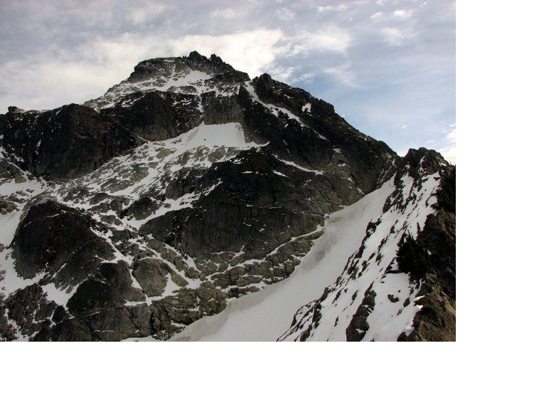
Well I found that mountain: Mt. Pugh just out of Darrington. Epic potential b/c there's potential for 4000 vertical foot shots from three chutes, two bowls, and mile-wide open glades. The 3000 ft glades may be something I try during a low elevation major storm event. The forests featured few rocks, wide spaces, and almost no blowdown, brush, of cliffage. From Stujack Pass there's the potential for a 4000 foot avalanche chute shot off the W-SW side or a 3000 ft bowl off the North side.
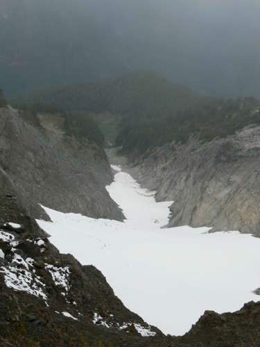
What really excited me however was the presence of a small glacier flowing North 600 feet or so below the summit. Starting at about 6400 feet the notch with the glacier in it runs a mile or longer strait as an arrow, and even now the permanent snow field/glacier looks to drop about a thousand vert of skiable. The mini-glacier is a bunch of snow trapped in something called the Strait Creek Fault-line. If I don't bag it this winter this will be a prime Spring shot and access to this mountain is year round; being so close to Darrington the Mountain Loop Highway is plowed here.
In good and relatively safe snow conditions Pugh offers up three grand descents.
Here's to hope. BTW, Pugh is nearly a 5k vert climb no matter the season. But it's short. That 5k happens in about five miles or less.
-jayme
more pics: http://picasaweb.google.com/jaymehelgeson/Pugh#
PS: there are a couple other TR's scattered around the TAY archives.
PS2: added photo from Josh Lewis at http://www.panoramio.com/photo/6468010
http://maps.google.com/maps?f=q&hl=en&geocode=&q=Mt+Pugh&sll=48.141349,-121.37558&sspn=0.051776,0.109863&ie=UTF8&ll=48.144671,-121.374292&spn=0.01363,0.027466&t=p&z=15&g=Mt+Pugh&iwloc=addr
But in this dismal November I was out to create hope, to find my secret stash with quick access from the Seattle area, to find a mountain with potential for epic descents.
Well I found that mountain: Mt. Pugh just out of Darrington. Epic potential b/c there's potential for 4000 vertical foot shots from three chutes, two bowls, and mile-wide open glades. The 3000 ft glades may be something I try during a low elevation major storm event. The forests featured few rocks, wide spaces, and almost no blowdown, brush, of cliffage. From Stujack Pass there's the potential for a 4000 foot avalanche chute shot off the W-SW side or a 3000 ft bowl off the North side.
What really excited me however was the presence of a small glacier flowing North 600 feet or so below the summit. Starting at about 6400 feet the notch with the glacier in it runs a mile or longer strait as an arrow, and even now the permanent snow field/glacier looks to drop about a thousand vert of skiable. The mini-glacier is a bunch of snow trapped in something called the Strait Creek Fault-line. If I don't bag it this winter this will be a prime Spring shot and access to this mountain is year round; being so close to Darrington the Mountain Loop Highway is plowed here.
In good and relatively safe snow conditions Pugh offers up three grand descents.
Here's to hope. BTW, Pugh is nearly a 5k vert climb no matter the season. But it's short. That 5k happens in about five miles or less.
-jayme
more pics: http://picasaweb.google.com/jaymehelgeson/Pugh#
PS: there are a couple other TR's scattered around the TAY archives.
PS2: added photo from Josh Lewis at http://www.panoramio.com/photo/6468010
http://maps.google.com/maps?f=q&hl=en&geocode=&q=Mt+Pugh&sll=48.141349,-121.37558&sspn=0.051776,0.109863&ie=UTF8&ll=48.144671,-121.374292&spn=0.01363,0.027466&t=p&z=15&g=Mt+Pugh&iwloc=addr

Cool. Sky went in there several times and I joined him on one trip. We skied from partway up the face in your last photo. Would love to get back there and ski it off the top, since we never did. Seems like it would have some nice steep skiing.
That is a really cool looking skiing objective. Good work on getting outside the box.
Nice recon! Darrington terrain is sick! Way to get out and give us some stoke in these difficult times!
Pugh is a beautiful mountain which would surely be a great ski (I have only booted it). In the department of getting to cool places in the winter, this is notable:
>>being so close to Darrington the Mountain Loop Highway is plowed here.
It means that the only addition to the regular approach in winter would be about 700 vf of the spur road up to the summer trailhead (early this summer even that was closed for some habitat reason).
>>being so close to Darrington the Mountain Loop Highway is plowed here.
It means that the only addition to the regular approach in winter would be about 700 vf of the spur road up to the summer trailhead (early this summer even that was closed for some habitat reason).
Thanks for all the stoke response!!!! Thanks guys! Now isn't there some snow coming this week?
I had a great standing glissade there once.
Savegondor - I wondered where you had got to. I always enjoyed your videos! Glad you're still climbing and skiing.
author=savegondor link=topic=11251.msg46473#msg46473 date=1227055594]
What really excited me however was the presence of a small glacier flowing North 600 feet or so below the summit. Starting at about 6400 feet the notch with the glacier in it runs a mile or longer strait as an arrow, and even now the permanent snow field/glacier looks to drop about a thousand vert of skiable. The mini-glacier is a bunch of snow trapped in something called the Strait Creek Fault-line. If I don't bag it this winter this will be a prime Spring shot and access to this mountain is year round; being so close to Darrington the Mountain Loop Highway is plowed here.
I hiked up there a couple years ago and noted that it could be a great ski in the right conditions. The chute off the back side that you reference above looked particularily interesting for a spring ski. I didn't realize that the Mt. Loop HW was plowed and this is a feasible trip in the winter/early spring (although it would be a lot of vertical in soft snow).
author=Scottk link=topic=11251.msg46612#msg46612 date=1227242021]
I hiked up there a couple years ago and noted that it could be a great ski in the right conditions. The chute off the back side that you reference above looked particularily interesting for a spring ski. I didn't realize that the Mt. Loop HW was plowed and this is a feasible trip in the winter/early spring (although it would be a lot of vertical in soft snow).
It's not plowed all they way. This part of the Mt. Loop is used as access for private residences. Barlow pass will most definitely close. It's very close to Darrington proper.
Good to see some attention to the Darrington area! This is some amazing country, but surprisingly does not get many tracks. Of course starting below 2000' makes a long day, but well worth the effort!
For slightly less-epic terrain (but same epic views and ambience), check out the Bedal Peak Route (Near Nels Lake).
I scouted this unofficial fisherman/climbers trail a month ago. Unlike the pugh access road, this one is not gated and one can usually drive up to near 2000' to start (road 4096 to Bedal Creek, heads out of second switchback). The route is well marked and reasonable to follow, clear of brush and most blowdown, up to 3000' (though still rougher than most trails). Here one can usually start skinning in winter/spring conditions, and offers excellent north facing open glades in old growth. The summit is much more accessible than Pugh, a moderate north facing slope the whole way. If anyone requests, I can post a map.
If you could post a map, I'd appreciate it greatly... Thanks Jeff
yes please post a map...i was also looking at the topo for Bedal and it looked good. "less epic" probably just means "more accessible". Pugh is an avalanche just waiting to happen. It's one large terreign trap.
added photo
Added map for bedal access info - see topic:
http://www.turns-all-year.com/skiing_snowboarding/trip_reports/index.php?topic=10193.new#new
http://www.turns-all-year.com/skiing_snowboarding/trip_reports/index.php?topic=10193.new#new
Reply to this TR
Please login first: