- Posts: 635
- Thank you received: 0
Freak 2-3ft Snowfall at Mission & Hurricane Ridges
- Amar Andalkar
-
 Topic Author
- User
-

Less
More
9 years 6 months ago - 9 years 6 months ago #228080
by Amar Andalkar
Freak 2-3ft Snowfall at Mission & Hurricane Ridges was created by Amar Andalkar
January 1-2, 2017: Freak Snowstorm Dumps over 2-3 ft of Snow at Hurricane Ridge and Mission Ridge!!!
but Near-ZERO Elsewhere in the Olympics and North/Central Cascades!?!?
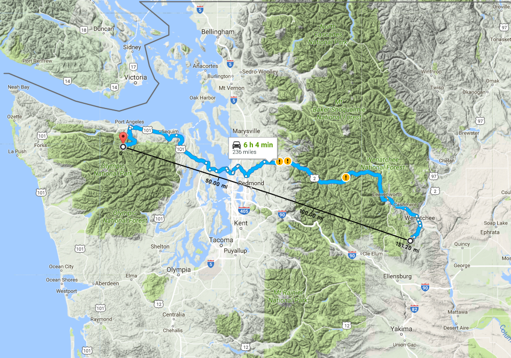
One of the most bizarre snow events ever observed in the Northwest has just occurred on New Year's Day 2017, extending into January 2. Both Hurricane Ridge on the northern side of the Olympic Mountains and Mission Ridge at the easternmost end of the Central Cascades received over 2-3 ft of new snow in a 24 hour period, while many other normally high-snowfall sites in the North Cascades and Central Cascades got zero new snow over the same time period!

[size=small]Three images from the Hurricane Ridge webcam: before the storm on December 31, at the height of the storm on January 1, and after the storm on January 2.
The wind pit in the first image was over 8 ft deep, as some tourists stood inside it a couple hours later.[/size]
How's this for a truly absurd table of new 24-hour snowfall amounts as of January 2, 2017, at a few selected locations in roughly north-south order:
[tt]
Mt Baker Ski Area 0" ??
Mazama 0" ??
Washington Pass 2" approx
Holden Village 0.5"
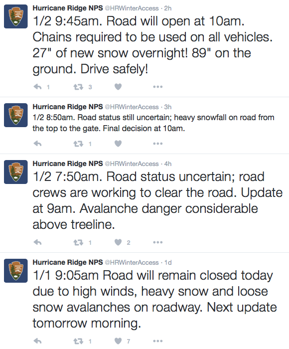
Hurricane Ridge 27" !!!
Lake Wenatchee 0" ??
Stevens Pass 0" ??
Snoqualmie Pass 0" ??
Blewett Pass 16"
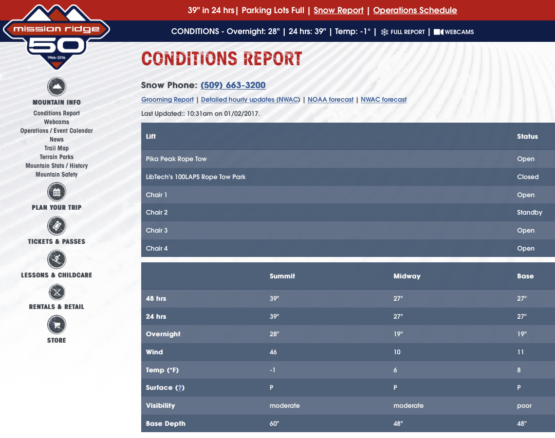
Mission Ridge, Midway 27" !!!
Mission Ridge, Summit 39" !?!?!
[/tt]
Farther south in the South Washington Cascades and the Oregon Cascades, non-zero snowfall amounts occurred at most sites:
[tt]
Crystal Mountain 4"
Mt Rainier, Sunrise 6" approx
Mt Rainier, Paradise 4" approx
White Pass 11"
Mt Hood, Timberline 12"
Mt Hood, Meadows 13"
Mt Bachelor Ski Area 10"
Crater Lake Park HQ 13"
Mt Ashland Ski Area 14"
[/tt]
It is almost certain that such an event (or anything even remotely similar) has never occurred before in the entire length of the historical weather records at these locations: combining extreme snowfall at those 2 totally-unrelated sites which are about 150 miles apart and located on opposite sides of the formidable weather barrier of the Cascade Crest (not to mention the waters of Puget Sound), along with near-zero snowfall at almost all other regional sites located between those 2 areas.
It boggles belief that this would even be possible at all. So where's the proof? Did it really happen at all?
Here are the reports from Olympic NP and the ski areas in the North and Central Cascades. First the huge dumps of 2-3 ft:
And over the same time period, ZERO at these ski areas which all have average annual snowfalls of 430-650":
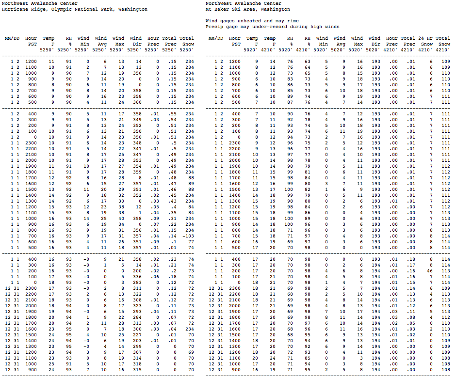
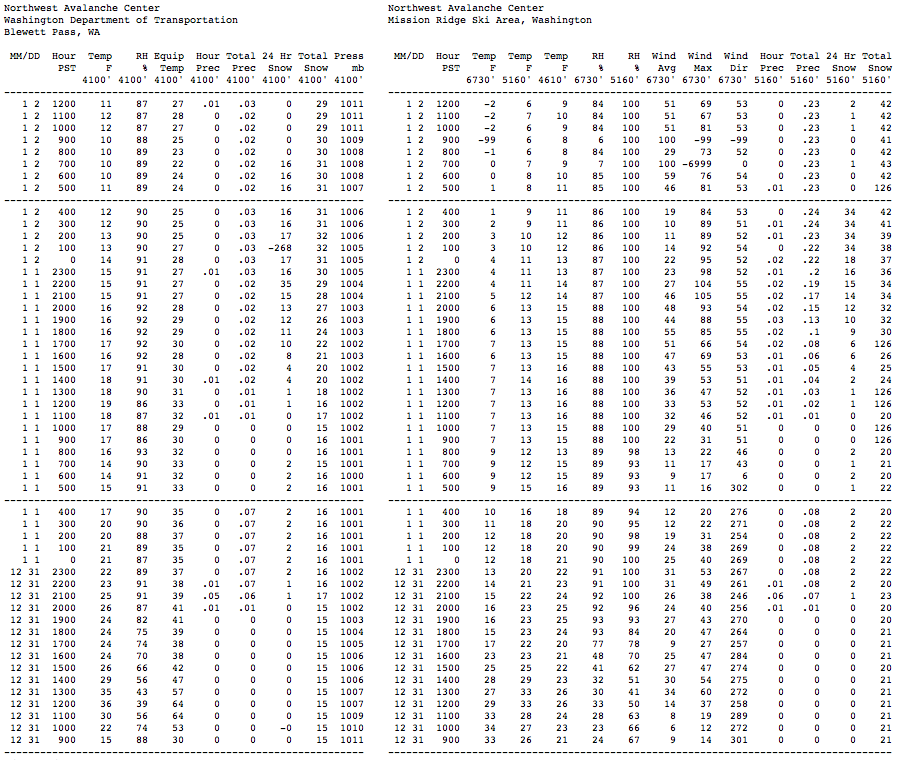
And does NWAC telemetry support the manually reported snowfall amounts? It does so quite well as seen below. I first noticed the extreme snowfall at the Hurricane Ridge and Mission Ridge NWAC telemetry sites on the evening of January 1 (after returning from skiing 13" of blower powder in the backcountry near Stevens Pass), and was immediately shocked and intrigued by what was happening.
At Hurricane Ridge, there is no 24-hour snowdepth sensor, so the change in total snowdepth is the best info available. Starting from about 72" at midnight on the New Year, the depth rapidly increases to 89", implying well over 20" of new snow up to that point. The weight of the new snow makes the older snow compact and settle, so a 17" change in a large snowdepth is never only 17" of new snow, unless the older snowpack is either solidly rain-crusted on top, or else a very dense late-spring / summer snowpack. The 234" values are spurious, that's the height of the snow sensor above the ground, so if falling snow or windblown new snow blocks or obscures the ultrasonic distance sensor, it reads that full height until the sensor opening is cleared. It's too bad the sensor did not register any valid totals after 5pm, even as additional snowfall continued to fall. Also note that the total precip amounts are likely to be incorrect, as very light powdery snowfall with moderate to strong winds causes severe undercatch in the precip gauge, so it's very unlikely that the 27" new contained only 0.66" of precip as recorded from midnight onward (that would imply a density under 2.5%, which is not possible in this area). Total precip was likely at least 1.5" or more, with density of 5-6% or greater (still true blower powder if not wind-hammered).
For comparison at Baker Ski Area, 8" new snow fell by 4am on the New Year and almost no additional snowfall was received after that. Ski patrollers at the area obviously forgot to clear off the 24-hour snow board that morning, an omission which has unfortunately happened on a few other days recently at that site too.
[size=small](These 2-column tables for nearby NWAC sites are generated by my NWAC script .)[/size]
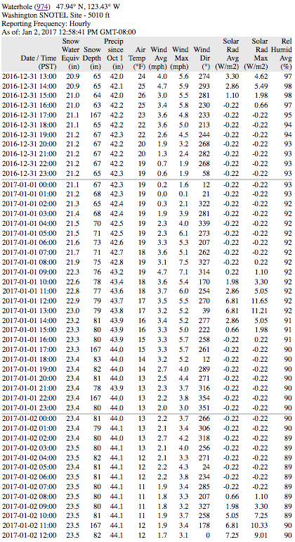
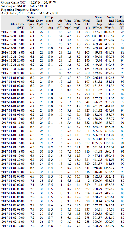
We can also do a comparison with the Waterhole SNOTEL site, located 4 miles SE of Hurricane Ridge along Obstruction Point Road. Like all SNOTEL sites, which are mostly located in remote locations far from daily human activity, there is no 24-hour snow sensor and only total snowdepth. Once again, there is about an 18" increase in snowdepth, implying around 2 ft of new snow or more. The next closest SNOTEL site is the Dungeness SNOTEL, located on the west slope of Mount Townsend, about 21 miles ESE of Hurricane Ridge, and still on the northern slopes of the Olympics. This site shows about an 11" increase in snowdepth, implying perhaps 16" of new snow, so heavy snowfall apparently occurred along much of the northern Olympic slope. The precip amounts at both SNOTEL sites are also much more believable, with 1.8" at Waterhole and 1" at Dungeness, which imply a density of 6-7%, very realistic given the conditions and temperatures.

[size=small](Tables generated by my SNOTEL script .)[/size]
In sharp contrast to these sites in the northern Olympics, the 2 SNOTEL sites in other parts of the Olympic Mountains (Mount Crag and Buckinghorse SNOTEL, normally by far the snowiest site in the Olympics) showed very little snowfall during this event.
The Mission Ridge NWAC telemetry site is located at Midway, and it shows an increase in snowdepth of 23", from 20" up to 43". Even though there is a 24-hour sensor, the heavy snowfall obscured the sensor after 18" was recorded at midnight on January 2, and the 34" values after that are spurious, equal to the height of the sensor above the 24-hour snowfall board. Regardless, the 23" increase in depth is consistent with the reported 27" new snowfall amount. Once again as at Hurricane Ridge, the precip amount of 0.24" is far too low, and total precip was likely at least 1" or more, with density of 4% or greater. I'm not sure where the summit snowstake at Mission Ridge which showed 39" new is located, but perhaps someone who is very familiar with the area can post here and let me know (or even post a pic of the snowstake site). Note in particular the strong winds at the summit, which exceeded 100 mph during 2 hours at the peak of the storm, and gusted over 80 mph during 12 consecutive hours from 6pm January 1 to 5am January 2.
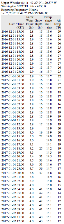
There are also 4 nearby SNOTEL sites which are well worth checking. The closest is the Upper Wheeler SNOTEL, located 1.5 miles east of the Mission Ridge Ski Area base and about 300 ft lower, which shows an increase from 15" up to 42", a 27" increase which given the shallow pre-existing snowpack, implies new snowfall of around 30" or more. The precip amount of 1.3" seems reasonable as it gives a 4% density.
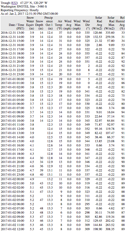
A bit farther eastward is the jackpot: the Trough SNOTEL near Naneum Ridge Rd, located 7 miles SE of the Mission Ridge Ski Area base, and only 9 miles west of the Columbia River, at roughly the same elevation as Midway on Mission. This site shows the largest new snowfall of any telemetry site, with an increase from 14" up to 48", an astonishing 34" increase which given the same shallow pre-existing snowpack, implies new snowfall of almost 40". So this completely matches the number reported from the Mission Ridge summit snowstake. The precip amount of 1" is at least closer to reality than the NWAC site, but is probably still well shy of the true value since it gives a density of only 2.5%, so it's probably over 1.5" which would give a 4% density.
Heading westward, the Grouse Camp SNOTEL, located 3 miles west of the top of Mission Ridge Ski Area and 6 miles SE of Blewett Pass, shows an increase from 23" up to 38", a 15" increase which implies new snowfall near 18". Blewett Pass is only 9 miles WNW of Mission Ridge Ski Area, and the NWAC site there received 17" of snowfall during this event. The Blewett Pass SNOTEL site is actually located near old Blewett Pass, 5 miles WNW of Blewett Pass on US 97 and 14 miles WNW of Mission Ridge Ski Area, and it shows an increase from 22" to 30", implying new snowfall of nearly 1 ft. So there is clearly a gradient of decreasing snowfall heading westward along the Wenatchee Mountains, with maximum amounts near Mission Ridge and extending several miles east of it.
Meanwhile, other locations farther north and west such as the Sasse Ridge SNOTEL, located 1.5 miles east of the Salmon La Sac Road and 23 miles WNW of Blewett Pass, got very little new snowfall, perhaps 2-3" at most, while even farther north and west at Lake Wenatchee, Stevens Pass, and Snoqualmie Pass there was almost none.
So now that it's well verified that this bizzarre snowfall event combining both huge dumps and near-zero amounts actually did occur, the obvious question is what caused it?
The primary cause of both heavy snowfall events was a low-pressure system which moved onto the Pacific Coast and then tracked slowly eastward along roughly the WA-OR border (along the Columbia Gorge, but unrelated to any effects of the Gorge itself), almost stalling during the afternoon and evening hours of January 1. Watching this system on the radar, it was easy to see the obvious counterclockwise swirl of winds and precip around its center as it very slowly crept eastward over several hours. This particular storm track location causes southeasterly upslope winds along the Wenatchee Mountains (an ESE-trending branch of the Cascade Range) and also along the east slopes of the South Washington Cascades. It's the primary (perhaps only?) storm track which produces heavy snowfall in the usually snow-starved eastern end of the Wenatchee Mountains, in particular from around Mission Ridge towards the Columbia River. The non-zero snowfall amounts of a few inches to about 1 ft in the South Washington Cascades and the Oregon Cascades were just regular storm snowfall from this otherwise very typical wintertime low-pressure system.
Here's a plot from the UW WRF-GFS weather model showing the storm system at 4pm January 1, as the period of maximum snowfall intensity was underway at Mission Ridge and winding down at Hurricane Ridge. This graphic shows the initial pressure, temperature, and wind fields at the start of that model run on the 850 mb pressure surface, which is normally about 5000 ft elevation, but more like 4400 ft at this time due to low pressure (the central L of 1332 m = 4370 ft).
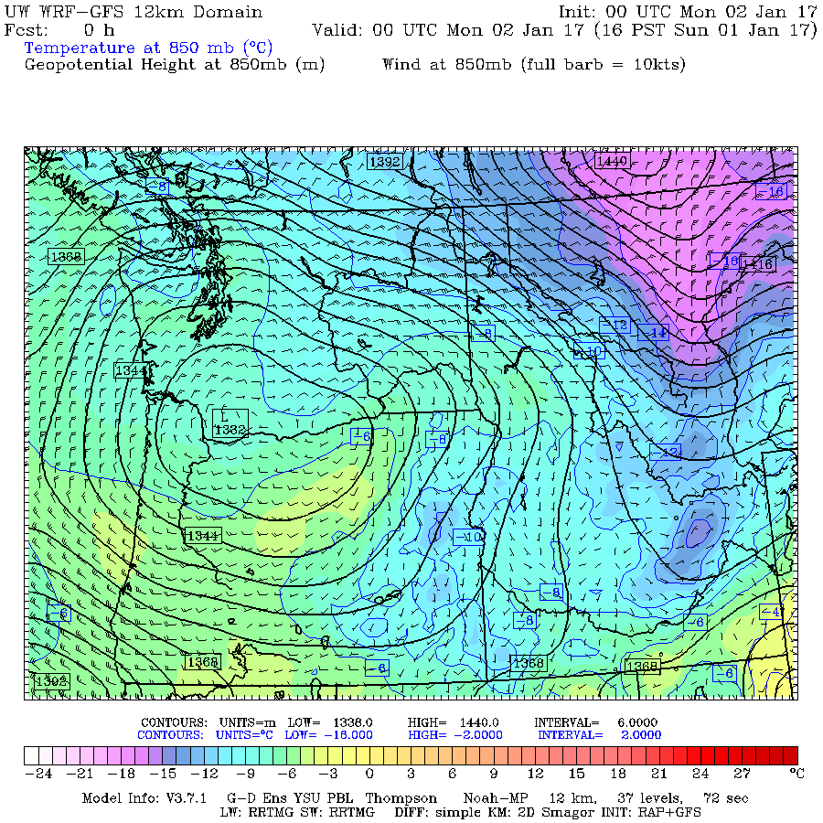
But how did a low-pressure system way down south along the Columbia Gorge cause the heavy snowfall on the northern slope of the Olympics? The very presence of low pressure in that region, combined with incoming extremely cold high pressure far to the northeast over the interior of BC, caused a strong pressure gradient and an increase in northeasterly outflow winds from the Frasier River canyon. This arctic outflow ends up aimed almost directly onto the northern slopes of the Olympic Mountains, and the cold dry air can entrain moisture as it crosses the relatively warm waters of the Salish Sea (Straits of Georgia and Juan de Fuca), resulting in heavy snowfall as the outflow is forced to rise up the northern slopes. Basically, it's ocean effect snowfall, very akin to lake effect snowfall such as on the Great Lakes, and similarly the snowfall rates can be very high at 2-4" per hour, easily producing 2 ft totals or more in favored locations such as Hurricane Ridge. In addition, the graphic shows that the wind field around the low-pressure system in this area is also aimed in the same northeasterly direction as the outflow, further enhancing the effect.
These are my own interpretations of the likely causes, and since I'm no meteorologist, they may have errors in some ways. Please post any corrections or other insights into the causes of this event. It's probably unusual enough to be worth someone writing it up as a published journal article.
Another question of great interest is whether any of this freakish snowfall was predicted at all by any weather forecast: the answer to that is pretty much a solid NO! No forecast was even hinting at these kind of snowfall amounts prior to the onset of the heavy snowfall, or even during the height of the heavy snowfall. As of the morning of January 1, the usually quite-reliable NWS zone forecast ( www.wrh.noaa.gov/total_forecast/getprod....=sew&sid=sew&pil=zfp ) for the Olympics said the following:
[tt]
OLYMPICS-
400 AM PST SUN JAN 1 2017
TODAY...MOSTLY CLOUDY. A CHANCE OF SNOW SHOWERS IN THE MORNING... THEN A SLIGHT CHANCE OF SNOW SHOWERS IN THE AFTERNOON.
SNOW ACCUMULATION NEAR HURRICANE RIDGE AROUND 1 INCH.
[/tt]
Quite a difference between 1" predicted and 27" received!! Just before noon, after heavy snowfall had been occurring for hours, a Winter Weather Advisory was issued, and forecast snowfall amounts increased substantially:
[tt]
OLYMPICS-
1148 AM PST SUN JAN 1 2017
...WINTER WEATHER ADVISORY IN EFFECT UNTIL 6 PM PST THIS EVENING...
REST OF TODAY...NUMEROUS SNOW SHOWERS. NEW SNOW ACCUMULATION NEAR HURRICANE RIDGE OF 4 TO 6 INCHES.
[/tt]
By that time, a foot of new had already fallen at Hurricane Ridge, and over another foot was on the way. Even the late afternoon update was still not really predicting that the heavy snowfall would continue as it did until well past midnight:
[tt]
OLYMPICS-
343 PM PST SUN JAN 1 2017
...WINTER WEATHER ADVISORY IN EFFECT UNTIL 6 PM PST THIS EVENING...
TONIGHT...SNOW SHOWERS LIKELY. SNOW ACCUMULATION NEAR HURRICANE RIDGE OF 3 TO 5 INCHES.
[/tt]
So pretty much a solid miss on those forecasts for the Olympics.
What about near Mission Ridge? Unfortunately, the crest of the Wenatchee Mountains along the Chelan-Kittatas county line forms the border between the county forecast areas covered by the NWS Spokane and NWS Pendleton (OR) forecast offices, and neither office provides a zone forecast that really covers that area to even a minimal standard. They are on the border of the "East Slopes Northern Cascades" and "East Slopes of the Washington Cascades" zones from those 2 offices respectively, and the forecasts for each of those zones have little applicability to the type of highly-specific weather conditions in the Wenatchee Mountains which produce (the very rare) large snowfalls there. Didn't realize that until trying to look up the previous days zone forecasts now, that's a severe omission. So nothing to check there.
What about the UW WRF-GFS weather model , the fabled gold standard of Northwest weather prediction (especially mountain weather prediction) for the last decade or more. Did it see the heavy snowfall coming? Here's the final prediction for 24-hour snowfall through 4am January 2 over Washington, from the highest resolution 4/3-km run made on the morning of January 1:
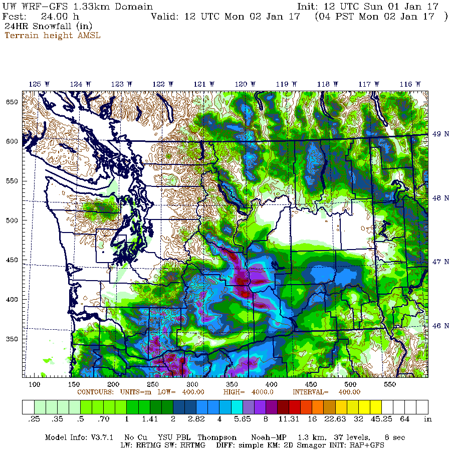
The same graphic, but showing the full 4/3-km domain which was recently expanded to include Oregon:

It certainly has the general idea correct, that there will be snowfall along the northern slopes of the Olympics and heavy snowfall along the crest of the Wenatchee Mountains, along with moderate snowfall throughout much of the South Washington Cascades and heavier snowfall up to 1 ft for the Oregon Cascades, and almost no snowfall for the North and Central Cascades, with amounts of 0-1" for most of that region. But the predicted snowfall amounts in what ended up as the heaviest snowfall areas are grossly incorrect, with only 2" predicted near Hurricane Ridge which turned into 27" and a maximum of 1 ft along the crest of the eastern Wenatchee Mountains near Mission Ridge which turned into over 3 ft.
As an interesting postscript, NWAC just posted their semimonthly snowdepth table for January 1, which showed snowdepths above normal at all sites listed except Mission Ridge, which was sadly well below normal. But only 1 day later, the snowdepth has doubled there, and the new depth of 42" is now about 135% of normal!
[tt]
CLIMATOLOGICAL SNOWDEPTH INFORMATION
NORTHWEST AVALANCHE CENTER SEATTLE WASHINGTON
DAY 1 MONTH 1 YEAR 2017
DATA IN INCHES, -99 DENOTES MISSING DATA
CURRENT CLIMATE PER CENT LAST THRU 2016 THRU 2016
DEPTH AVERAGE OF NORMAL YEAR MAX/YEAR MIN/YEAR
HURRICANE 74 57 130 81 97/2013 11/1981
MT BAKER 114 88 130 105 190/1949 1/1928
STEVENS 76 61 125 56 117/1956 10/1981
SNOQUALMIE 63 53 119 77 136/1949 0/1981
STAMPEDE 61 57 107 68 132/1949 0/1981
MISSION22 42 31 71 135 37 56/1997 6/1976
CRYSTAL 47 42 112 51 72/2007 5/1981
PARADISE 111 91 122 116 163/1969 20/1977
WHITE PASS 49 36 136 59 84/1997 2/2014
TIMBERLINE 104 79 132 90 173/1985 8/1977
MEADOWS 79 71 111 79 145/1985 6/1981
[/tt]
but Near-ZERO Elsewhere in the Olympics and North/Central Cascades!?!?
One of the most bizarre snow events ever observed in the Northwest has just occurred on New Year's Day 2017, extending into January 2. Both Hurricane Ridge on the northern side of the Olympic Mountains and Mission Ridge at the easternmost end of the Central Cascades received over 2-3 ft of new snow in a 24 hour period, while many other normally high-snowfall sites in the North Cascades and Central Cascades got zero new snow over the same time period!
[size=small]Three images from the Hurricane Ridge webcam: before the storm on December 31, at the height of the storm on January 1, and after the storm on January 2.
The wind pit in the first image was over 8 ft deep, as some tourists stood inside it a couple hours later.[/size]
How's this for a truly absurd table of new 24-hour snowfall amounts as of January 2, 2017, at a few selected locations in roughly north-south order:
[tt]
Mt Baker Ski Area 0" ??
Mazama 0" ??
Washington Pass 2" approx
Holden Village 0.5"
Hurricane Ridge 27" !!!
Lake Wenatchee 0" ??
Stevens Pass 0" ??
Snoqualmie Pass 0" ??
Blewett Pass 16"
Mission Ridge, Midway 27" !!!
Mission Ridge, Summit 39" !?!?!
[/tt]
Farther south in the South Washington Cascades and the Oregon Cascades, non-zero snowfall amounts occurred at most sites:
[tt]
Crystal Mountain 4"
Mt Rainier, Sunrise 6" approx
Mt Rainier, Paradise 4" approx
White Pass 11"
Mt Hood, Timberline 12"
Mt Hood, Meadows 13"
Mt Bachelor Ski Area 10"
Crater Lake Park HQ 13"
Mt Ashland Ski Area 14"
[/tt]
It is almost certain that such an event (or anything even remotely similar) has never occurred before in the entire length of the historical weather records at these locations: combining extreme snowfall at those 2 totally-unrelated sites which are about 150 miles apart and located on opposite sides of the formidable weather barrier of the Cascade Crest (not to mention the waters of Puget Sound), along with near-zero snowfall at almost all other regional sites located between those 2 areas.
It boggles belief that this would even be possible at all. So where's the proof? Did it really happen at all?
Here are the reports from Olympic NP and the ski areas in the North and Central Cascades. First the huge dumps of 2-3 ft:
And over the same time period, ZERO at these ski areas which all have average annual snowfalls of 430-650":
And does NWAC telemetry support the manually reported snowfall amounts? It does so quite well as seen below. I first noticed the extreme snowfall at the Hurricane Ridge and Mission Ridge NWAC telemetry sites on the evening of January 1 (after returning from skiing 13" of blower powder in the backcountry near Stevens Pass), and was immediately shocked and intrigued by what was happening.
At Hurricane Ridge, there is no 24-hour snowdepth sensor, so the change in total snowdepth is the best info available. Starting from about 72" at midnight on the New Year, the depth rapidly increases to 89", implying well over 20" of new snow up to that point. The weight of the new snow makes the older snow compact and settle, so a 17" change in a large snowdepth is never only 17" of new snow, unless the older snowpack is either solidly rain-crusted on top, or else a very dense late-spring / summer snowpack. The 234" values are spurious, that's the height of the snow sensor above the ground, so if falling snow or windblown new snow blocks or obscures the ultrasonic distance sensor, it reads that full height until the sensor opening is cleared. It's too bad the sensor did not register any valid totals after 5pm, even as additional snowfall continued to fall. Also note that the total precip amounts are likely to be incorrect, as very light powdery snowfall with moderate to strong winds causes severe undercatch in the precip gauge, so it's very unlikely that the 27" new contained only 0.66" of precip as recorded from midnight onward (that would imply a density under 2.5%, which is not possible in this area). Total precip was likely at least 1.5" or more, with density of 5-6% or greater (still true blower powder if not wind-hammered).
For comparison at Baker Ski Area, 8" new snow fell by 4am on the New Year and almost no additional snowfall was received after that. Ski patrollers at the area obviously forgot to clear off the 24-hour snow board that morning, an omission which has unfortunately happened on a few other days recently at that site too.
[size=small](These 2-column tables for nearby NWAC sites are generated by my NWAC script .)[/size]
We can also do a comparison with the Waterhole SNOTEL site, located 4 miles SE of Hurricane Ridge along Obstruction Point Road. Like all SNOTEL sites, which are mostly located in remote locations far from daily human activity, there is no 24-hour snow sensor and only total snowdepth. Once again, there is about an 18" increase in snowdepth, implying around 2 ft of new snow or more. The next closest SNOTEL site is the Dungeness SNOTEL, located on the west slope of Mount Townsend, about 21 miles ESE of Hurricane Ridge, and still on the northern slopes of the Olympics. This site shows about an 11" increase in snowdepth, implying perhaps 16" of new snow, so heavy snowfall apparently occurred along much of the northern Olympic slope. The precip amounts at both SNOTEL sites are also much more believable, with 1.8" at Waterhole and 1" at Dungeness, which imply a density of 6-7%, very realistic given the conditions and temperatures.
[size=small](Tables generated by my SNOTEL script .)[/size]
In sharp contrast to these sites in the northern Olympics, the 2 SNOTEL sites in other parts of the Olympic Mountains (Mount Crag and Buckinghorse SNOTEL, normally by far the snowiest site in the Olympics) showed very little snowfall during this event.
The Mission Ridge NWAC telemetry site is located at Midway, and it shows an increase in snowdepth of 23", from 20" up to 43". Even though there is a 24-hour sensor, the heavy snowfall obscured the sensor after 18" was recorded at midnight on January 2, and the 34" values after that are spurious, equal to the height of the sensor above the 24-hour snowfall board. Regardless, the 23" increase in depth is consistent with the reported 27" new snowfall amount. Once again as at Hurricane Ridge, the precip amount of 0.24" is far too low, and total precip was likely at least 1" or more, with density of 4% or greater. I'm not sure where the summit snowstake at Mission Ridge which showed 39" new is located, but perhaps someone who is very familiar with the area can post here and let me know (or even post a pic of the snowstake site). Note in particular the strong winds at the summit, which exceeded 100 mph during 2 hours at the peak of the storm, and gusted over 80 mph during 12 consecutive hours from 6pm January 1 to 5am January 2.
There are also 4 nearby SNOTEL sites which are well worth checking. The closest is the Upper Wheeler SNOTEL, located 1.5 miles east of the Mission Ridge Ski Area base and about 300 ft lower, which shows an increase from 15" up to 42", a 27" increase which given the shallow pre-existing snowpack, implies new snowfall of around 30" or more. The precip amount of 1.3" seems reasonable as it gives a 4% density.
A bit farther eastward is the jackpot: the Trough SNOTEL near Naneum Ridge Rd, located 7 miles SE of the Mission Ridge Ski Area base, and only 9 miles west of the Columbia River, at roughly the same elevation as Midway on Mission. This site shows the largest new snowfall of any telemetry site, with an increase from 14" up to 48", an astonishing 34" increase which given the same shallow pre-existing snowpack, implies new snowfall of almost 40". So this completely matches the number reported from the Mission Ridge summit snowstake. The precip amount of 1" is at least closer to reality than the NWAC site, but is probably still well shy of the true value since it gives a density of only 2.5%, so it's probably over 1.5" which would give a 4% density.
Heading westward, the Grouse Camp SNOTEL, located 3 miles west of the top of Mission Ridge Ski Area and 6 miles SE of Blewett Pass, shows an increase from 23" up to 38", a 15" increase which implies new snowfall near 18". Blewett Pass is only 9 miles WNW of Mission Ridge Ski Area, and the NWAC site there received 17" of snowfall during this event. The Blewett Pass SNOTEL site is actually located near old Blewett Pass, 5 miles WNW of Blewett Pass on US 97 and 14 miles WNW of Mission Ridge Ski Area, and it shows an increase from 22" to 30", implying new snowfall of nearly 1 ft. So there is clearly a gradient of decreasing snowfall heading westward along the Wenatchee Mountains, with maximum amounts near Mission Ridge and extending several miles east of it.
Meanwhile, other locations farther north and west such as the Sasse Ridge SNOTEL, located 1.5 miles east of the Salmon La Sac Road and 23 miles WNW of Blewett Pass, got very little new snowfall, perhaps 2-3" at most, while even farther north and west at Lake Wenatchee, Stevens Pass, and Snoqualmie Pass there was almost none.
So now that it's well verified that this bizzarre snowfall event combining both huge dumps and near-zero amounts actually did occur, the obvious question is what caused it?
The primary cause of both heavy snowfall events was a low-pressure system which moved onto the Pacific Coast and then tracked slowly eastward along roughly the WA-OR border (along the Columbia Gorge, but unrelated to any effects of the Gorge itself), almost stalling during the afternoon and evening hours of January 1. Watching this system on the radar, it was easy to see the obvious counterclockwise swirl of winds and precip around its center as it very slowly crept eastward over several hours. This particular storm track location causes southeasterly upslope winds along the Wenatchee Mountains (an ESE-trending branch of the Cascade Range) and also along the east slopes of the South Washington Cascades. It's the primary (perhaps only?) storm track which produces heavy snowfall in the usually snow-starved eastern end of the Wenatchee Mountains, in particular from around Mission Ridge towards the Columbia River. The non-zero snowfall amounts of a few inches to about 1 ft in the South Washington Cascades and the Oregon Cascades were just regular storm snowfall from this otherwise very typical wintertime low-pressure system.
Here's a plot from the UW WRF-GFS weather model showing the storm system at 4pm January 1, as the period of maximum snowfall intensity was underway at Mission Ridge and winding down at Hurricane Ridge. This graphic shows the initial pressure, temperature, and wind fields at the start of that model run on the 850 mb pressure surface, which is normally about 5000 ft elevation, but more like 4400 ft at this time due to low pressure (the central L of 1332 m = 4370 ft).
But how did a low-pressure system way down south along the Columbia Gorge cause the heavy snowfall on the northern slope of the Olympics? The very presence of low pressure in that region, combined with incoming extremely cold high pressure far to the northeast over the interior of BC, caused a strong pressure gradient and an increase in northeasterly outflow winds from the Frasier River canyon. This arctic outflow ends up aimed almost directly onto the northern slopes of the Olympic Mountains, and the cold dry air can entrain moisture as it crosses the relatively warm waters of the Salish Sea (Straits of Georgia and Juan de Fuca), resulting in heavy snowfall as the outflow is forced to rise up the northern slopes. Basically, it's ocean effect snowfall, very akin to lake effect snowfall such as on the Great Lakes, and similarly the snowfall rates can be very high at 2-4" per hour, easily producing 2 ft totals or more in favored locations such as Hurricane Ridge. In addition, the graphic shows that the wind field around the low-pressure system in this area is also aimed in the same northeasterly direction as the outflow, further enhancing the effect.
These are my own interpretations of the likely causes, and since I'm no meteorologist, they may have errors in some ways. Please post any corrections or other insights into the causes of this event. It's probably unusual enough to be worth someone writing it up as a published journal article.
Another question of great interest is whether any of this freakish snowfall was predicted at all by any weather forecast: the answer to that is pretty much a solid NO! No forecast was even hinting at these kind of snowfall amounts prior to the onset of the heavy snowfall, or even during the height of the heavy snowfall. As of the morning of January 1, the usually quite-reliable NWS zone forecast ( www.wrh.noaa.gov/total_forecast/getprod....=sew&sid=sew&pil=zfp ) for the Olympics said the following:
[tt]
OLYMPICS-
400 AM PST SUN JAN 1 2017
TODAY...MOSTLY CLOUDY. A CHANCE OF SNOW SHOWERS IN THE MORNING... THEN A SLIGHT CHANCE OF SNOW SHOWERS IN THE AFTERNOON.
SNOW ACCUMULATION NEAR HURRICANE RIDGE AROUND 1 INCH.
[/tt]
Quite a difference between 1" predicted and 27" received!! Just before noon, after heavy snowfall had been occurring for hours, a Winter Weather Advisory was issued, and forecast snowfall amounts increased substantially:
[tt]
OLYMPICS-
1148 AM PST SUN JAN 1 2017
...WINTER WEATHER ADVISORY IN EFFECT UNTIL 6 PM PST THIS EVENING...
REST OF TODAY...NUMEROUS SNOW SHOWERS. NEW SNOW ACCUMULATION NEAR HURRICANE RIDGE OF 4 TO 6 INCHES.
[/tt]
By that time, a foot of new had already fallen at Hurricane Ridge, and over another foot was on the way. Even the late afternoon update was still not really predicting that the heavy snowfall would continue as it did until well past midnight:
[tt]
OLYMPICS-
343 PM PST SUN JAN 1 2017
...WINTER WEATHER ADVISORY IN EFFECT UNTIL 6 PM PST THIS EVENING...
TONIGHT...SNOW SHOWERS LIKELY. SNOW ACCUMULATION NEAR HURRICANE RIDGE OF 3 TO 5 INCHES.
[/tt]
So pretty much a solid miss on those forecasts for the Olympics.
What about near Mission Ridge? Unfortunately, the crest of the Wenatchee Mountains along the Chelan-Kittatas county line forms the border between the county forecast areas covered by the NWS Spokane and NWS Pendleton (OR) forecast offices, and neither office provides a zone forecast that really covers that area to even a minimal standard. They are on the border of the "East Slopes Northern Cascades" and "East Slopes of the Washington Cascades" zones from those 2 offices respectively, and the forecasts for each of those zones have little applicability to the type of highly-specific weather conditions in the Wenatchee Mountains which produce (the very rare) large snowfalls there. Didn't realize that until trying to look up the previous days zone forecasts now, that's a severe omission. So nothing to check there.
What about the UW WRF-GFS weather model , the fabled gold standard of Northwest weather prediction (especially mountain weather prediction) for the last decade or more. Did it see the heavy snowfall coming? Here's the final prediction for 24-hour snowfall through 4am January 2 over Washington, from the highest resolution 4/3-km run made on the morning of January 1:
The same graphic, but showing the full 4/3-km domain which was recently expanded to include Oregon:
It certainly has the general idea correct, that there will be snowfall along the northern slopes of the Olympics and heavy snowfall along the crest of the Wenatchee Mountains, along with moderate snowfall throughout much of the South Washington Cascades and heavier snowfall up to 1 ft for the Oregon Cascades, and almost no snowfall for the North and Central Cascades, with amounts of 0-1" for most of that region. But the predicted snowfall amounts in what ended up as the heaviest snowfall areas are grossly incorrect, with only 2" predicted near Hurricane Ridge which turned into 27" and a maximum of 1 ft along the crest of the eastern Wenatchee Mountains near Mission Ridge which turned into over 3 ft.
As an interesting postscript, NWAC just posted their semimonthly snowdepth table for January 1, which showed snowdepths above normal at all sites listed except Mission Ridge, which was sadly well below normal. But only 1 day later, the snowdepth has doubled there, and the new depth of 42" is now about 135% of normal!
[tt]
CLIMATOLOGICAL SNOWDEPTH INFORMATION
NORTHWEST AVALANCHE CENTER SEATTLE WASHINGTON
DAY 1 MONTH 1 YEAR 2017
DATA IN INCHES, -99 DENOTES MISSING DATA
CURRENT CLIMATE PER CENT LAST THRU 2016 THRU 2016
DEPTH AVERAGE OF NORMAL YEAR MAX/YEAR MIN/YEAR
HURRICANE 74 57 130 81 97/2013 11/1981
MT BAKER 114 88 130 105 190/1949 1/1928
STEVENS 76 61 125 56 117/1956 10/1981
SNOQUALMIE 63 53 119 77 136/1949 0/1981
STAMPEDE 61 57 107 68 132/1949 0/1981
MISSION
CRYSTAL 47 42 112 51 72/2007 5/1981
PARADISE 111 91 122 116 163/1969 20/1977
WHITE PASS 49 36 136 59 84/1997 2/2014
TIMBERLINE 104 79 132 90 173/1985 8/1977
MEADOWS 79 71 111 79 145/1985 6/1981
[/tt]
Please Log in or Create an account to join the conversation.
- flowing alpy
-
- User
-
Less
More
- Posts: 1272
- Thank you received: 0
9 years 6 months ago #228081
by flowing alpy
Replied by flowing alpy on topic Re: Freak 2-3ft Snowfall at Mission & Hurricane Ridges
Thanks Amar! totally makes sense when you explain it like that.
Please Log in or Create an account to join the conversation.
- aaron_wright
-
- User
-
Less
More
- Posts: 429
- Thank you received: 0
9 years 6 months ago #228082
by aaron_wright
Replied by aaron_wright on topic Re: Freak 2-3ft Snowfall at Mission & Hurricane Ridges
This happens infrequently here at Mission Amar but the cyclonic low pressure systems that track through the Columbia Gorge are well know snow makers here. If they spin up into the basin and get sandwiched between an advancing arctic front and warm front to the south we get these "freak" snowfalls. Last one I remember was 1/10-11/07.
When I drove up yesterday around noon, there were patches of blue sky to the north in town and as I drove further up the canyon the snow steadily increase to near blizzard conditions by the time I got to the lot. I had 8"+ on my car from noon to 4:45 when I left.
When I drove up yesterday around noon, there were patches of blue sky to the north in town and as I drove further up the canyon the snow steadily increase to near blizzard conditions by the time I got to the lot. I had 8"+ on my car from noon to 4:45 when I left.
Please Log in or Create an account to join the conversation.
- Amar Andalkar
-
Topic Author
- User
-
Less
More
- Posts: 635
- Thank you received: 0
9 years 6 months ago - 9 years 6 months ago #228086
by Amar Andalkar
Replied by Amar Andalkar on topic Re: Freak 2-3ft Snowfall at Mission & Hurricane Ridges
Edited the original post to add an analysis of the forecast predictions, which obviously did not see this heavy snowfall coming very well at all . . .
And also added the three-image animation from the Hurricane Ridge webcam.
Later added the 850 mb graphic, the 2nd model snowfall graphic covering both OR and WA, and made several other tweaks.
Note that there was some kind of major data outage around midnight on January 2 which affected all of the over 1100 SNOTEL and SCAN telemetry sites run by NRCS nationwide, so all those sites were missing 6-7 hours of data at the time the original post was written. On January 3, the missing data reappeared, and so the 5 SNOTEL data tables in the original post were updated to include that missing data.
Please Log in or Create an account to join the conversation.
- jtack
-
- User
-
Less
More
- Posts: 126
- Thank you received: 1
9 years 6 months ago - 9 years 6 months ago #228092
by jtack
Replied by jtack on topic Re: Freak 2-3ft Snowfall at Mission & Hurricane Ridges
Amar, while it is unprecedented to get the amount of snow we had yesterday, events like this, all be it much shorter in length happen almost every year. (a non scientific observation of similar conditions)
Jan 1, at the top of the lift, you could see the sun shining through the obscuration formed by the weather piling in from the east. In Wenatchee ten air miles east, we had two inches accumulation from Jan 1 and 2.
The skiing was deep.
Jan 1, at the top of the lift, you could see the sun shining through the obscuration formed by the weather piling in from the east. In Wenatchee ten air miles east, we had two inches accumulation from Jan 1 and 2.
The skiing was deep.
Please Log in or Create an account to join the conversation.
- Stormking
-
- User
-
Less
More
- Posts: 83
- Thank you received: 0
9 years 6 months ago - 9 years 6 months ago #228095
by Stormking
Replied by Stormking on topic Re: Freak 2-3ft Snowfall at Mission & Hurricane Ridges
Nice write up. I did a paper about the northern Olympic Peninsula strait effect snow phenomena while at UW in the early '90s. I was inspired after a similar storm that happened then which dumped 30" of snow at the 500+ foot level in the PA area, while the rest of the PNW was clear and cold. At that time, I did not think to see if there was a connection to Mission Ridge snowfall.
I've noticed that the NWS has mentioned strait effect snow as a possibility a few times in recent years with Fraser Outflow events. Enough that I didn't expect it to happen this time because it wasn't mentioned and figured they had a handle on why it wouldn't.
Also of note was that on the 30th, when the outflow was first beginning, the band of moisture was more at the 4,000' level. Above that elevation was clear, but a fairly heavy snowfall in the band of clouds that changed to rain just at sea level, and then clear again out over the Strait. I have some pictures of that if I can figure out to get them from my phone to this site. Made for a beautiful alpenglow sunset. Also, the snow continued to fall all day on the 2nd at the Ridge, while it was pretty much clear in town.
BTW the skiing was fantastic. (And very unfortunate that the road is now closed at the gate with all that blower pow up there).
Please Log in or Create an account to join the conversation.