- Posts: 635
- Thank you received: 0
Freak 2-3ft Snowfall at Mission & Hurricane Ridges
- Amar Andalkar
-
 Topic Author
- User
-

Less
More
9 years 6 months ago - 9 years 6 months ago #228131
by Amar Andalkar
Replied by Amar Andalkar on topic Re: Freak 2-3ft Snowfall at Mission & Hurricane Ridges
100+ mph Easterly Pass Flow Winds at Crystal and Mount Hood, 04Jan2017!
Another somewhat freakish weather event event occurred today: 100+ mph easterly pass flow winds atop Crystal Mountain and at both upper NWAC sites on Mount Hood! Among the strongest easterly winds I've ever seen at those sites, although normal SW storm winds can exceed that mark a few times per year.
And the extreme easterly winds are related to both the event which is the subject of this thread, and also to the first storm system hitting California as part of their huge storm cycle (see the other thread: 10-20 ft Snowfall Predicted for CA, 02-13Jan2017!! ). I don't want to start a 3rd weather post at the same time now, so I'll just discuss the high wind event here.
First, here's the telemetry from those NWAC sites, showing the rapid increase in easterly wind starting late on the evening of January 3 and continuing until evening the next day:
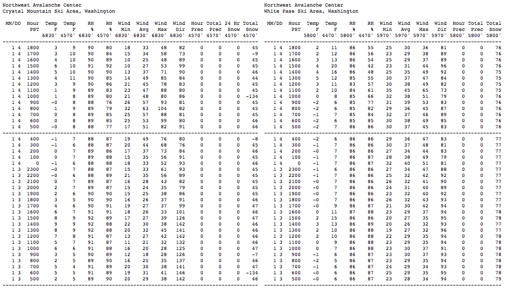
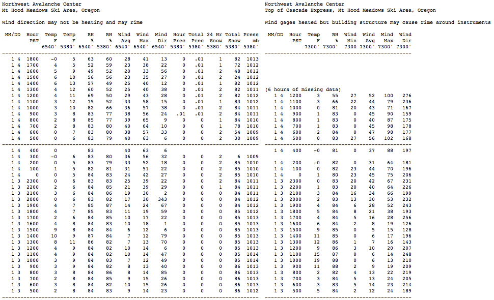
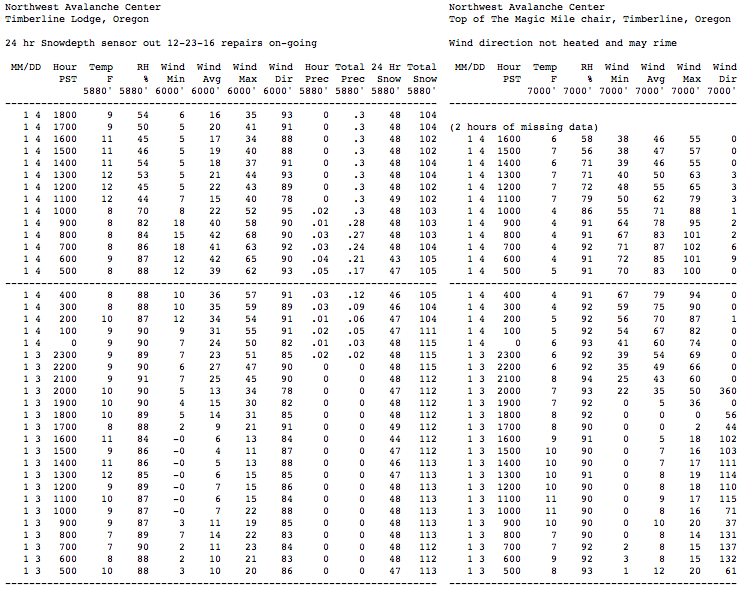
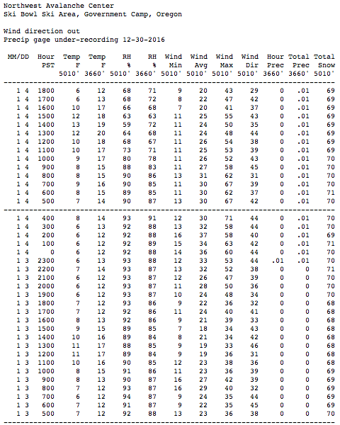
Winds were much less (albeit still quite strong) atop White Pass than atop Crystal, and similarly less at Ski Bowl versus the higher sites on Mount Hood itself. Passes farther north in Washington had even more moderate easterly winds. I also checked several RAWS and AgriMet telemetry sites located in the Columbia Gorge which have wind data, and only light to moderate winds were seen at any of those sites.
So what caused the extreme winds at Crystal and Hood?
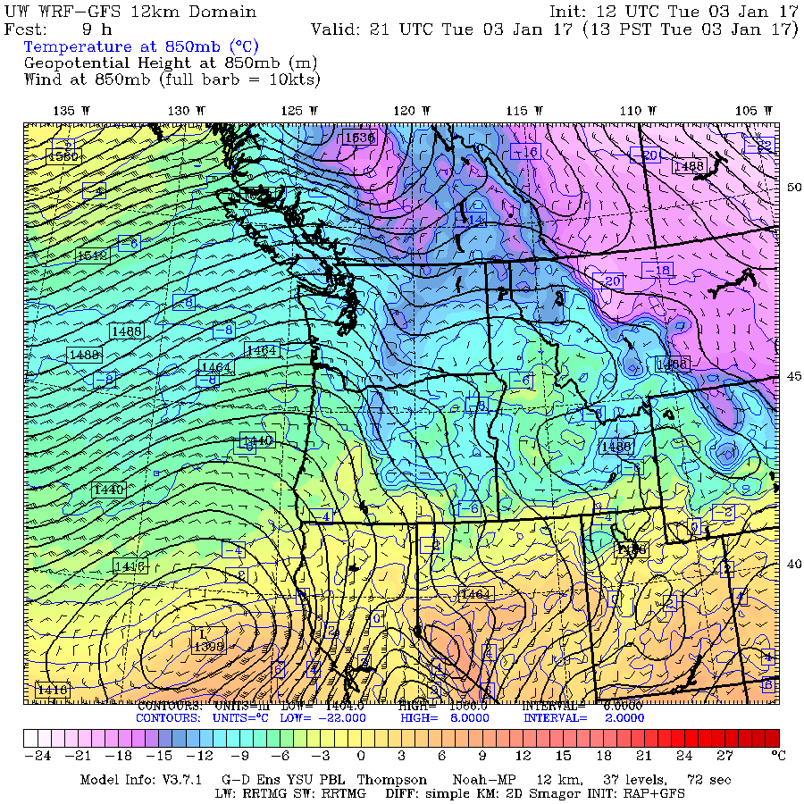
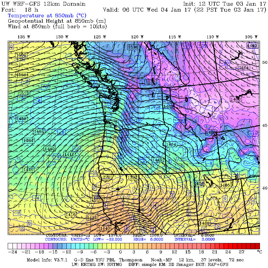
The best tool I've found for viewing the distribution of easterly pass flow winds is the UW WRF-GFS weather model , specifically the 4km 850mb "Temp, winds, heights" plots, since 850mb is right about at the 5000 ft level, which is in the middle of the typical elevation span of such winds (3000 ft at the lowest pass, up to about 8000 ft maximum). The higher resolution 4/3 km version of the same plot is much too hard to read, and not useful. I usually use the zoomed in 4km 850mb "Western WA Temp, winds, heights" for the local winds at my common ski destinations, but the plots below all show the full state of WA in order to see winds down near Mount Hood.
As of early Tuesday morning, the plot shows moderate easterly pass flow winds of 10-20 mph (1 knot = 1.15 mph) across the Cascade Crest:

By Tuesday afternoon, winds have increased only slightly, to 20-30 mph:
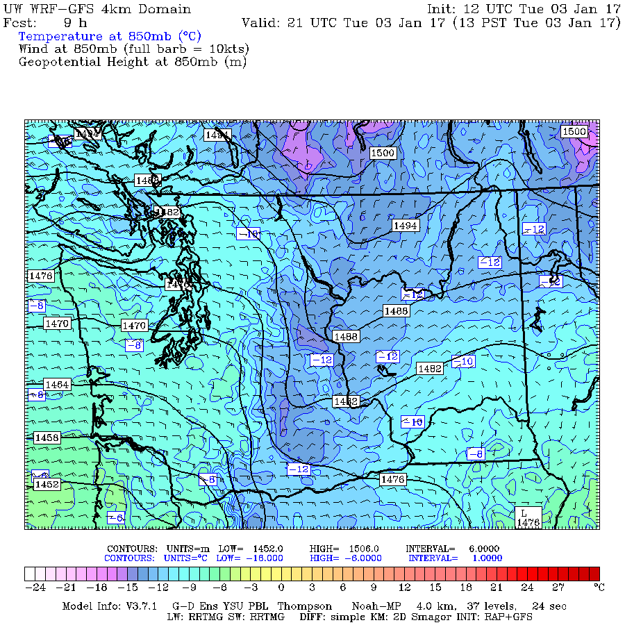
By late Tuesday evening, winds have increased substantially to 40-50 mph in spots, driven by a sharp increase in the pressure gradient as seen by the closely spaced black contours:
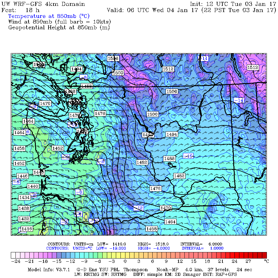
By Wednesday morning, the pressure gradient and winds have reached a maximum, with 50-60 mph winds in spots (the triangular barbs on the wind arrows are 50 knots, almost 60 mph), the same hours that the highest winds are seen in the telemetry data:
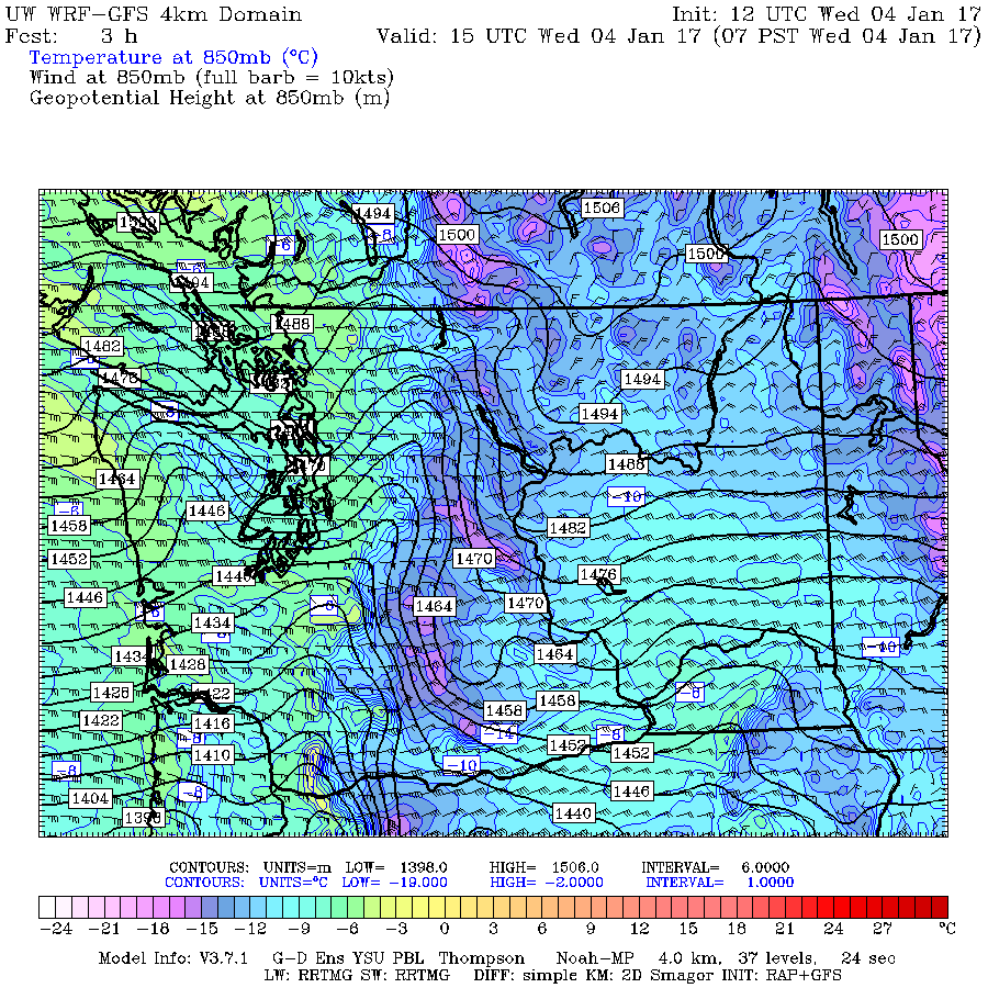
By late Wednesday afternoon (a few hours before this was written), the pressure gradient and winds have begun to diminish substantially:

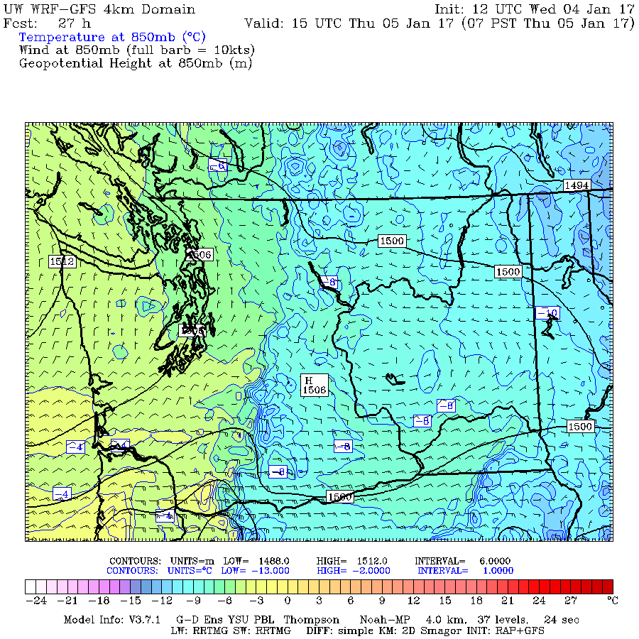
By Thursday morning, the pressure gradient is forecast to vanish almost completely, and winds will diminish to near zero over the northern half of the Crest, and only 10-20 mph farther south near Oregon. Note that temperatures just east of the Crest have will also warm substantially by about 8-10 °C (almost 15-20 °F) from only 24 hours earlier:
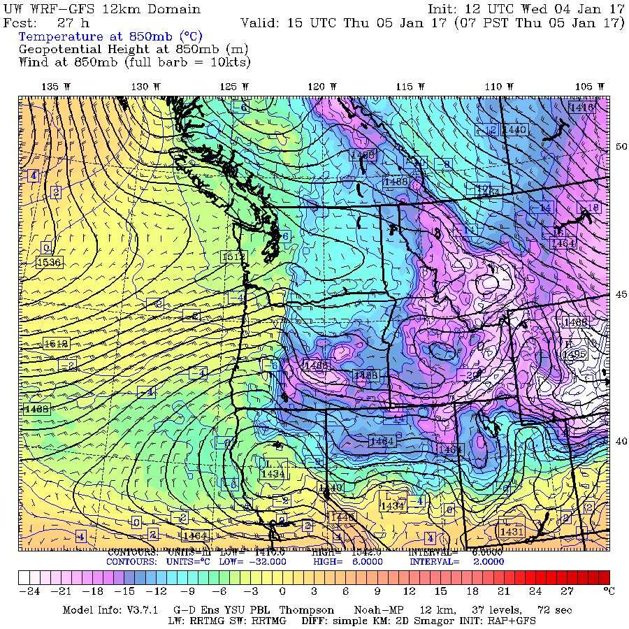
So the link from the high winds to the subject of this thread is the cold Arctic air trapped east of the barrier of the Cascade Range. And the link to the storm system affecting California can be seen by zooming out on the same 850mb plots to show the full domain of the lower 12km resolution. By Tuesday afternoon, a low-pressure center has developed off the California coast:
By late Tuesday evening, the low has intensified greatly and moved onto the coast at the Oregon-California border, causing the sharp increase in the pressure gradient:
By Wednesday morning, this low has intensified slightly more and tracked northward along the coast to its most northern position, which increased the pressure gradient even more up to its maximum value:

By late Wednesday afternoon, the low has weakened substantially and even moved in a retrograde direction, back west and south of its previous position:
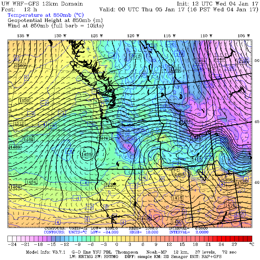
By Thursday morning, the low is forecast to weaken further and move SE into northern California. Over the previous 48 hours, it will have moved in a complete loop! A substantial pressure gradient and easterly pass flow winds exist only over the crest of the Oregon Cascades by that time:
Pretty interesting stuff, especially its connections to the other two major weather events of early January 2017!
Another somewhat freakish weather event event occurred today: 100+ mph easterly pass flow winds atop Crystal Mountain and at both upper NWAC sites on Mount Hood! Among the strongest easterly winds I've ever seen at those sites, although normal SW storm winds can exceed that mark a few times per year.
And the extreme easterly winds are related to both the event which is the subject of this thread, and also to the first storm system hitting California as part of their huge storm cycle (see the other thread: 10-20 ft Snowfall Predicted for CA, 02-13Jan2017!! ). I don't want to start a 3rd weather post at the same time now, so I'll just discuss the high wind event here.
First, here's the telemetry from those NWAC sites, showing the rapid increase in easterly wind starting late on the evening of January 3 and continuing until evening the next day:
Winds were much less (albeit still quite strong) atop White Pass than atop Crystal, and similarly less at Ski Bowl versus the higher sites on Mount Hood itself. Passes farther north in Washington had even more moderate easterly winds. I also checked several RAWS and AgriMet telemetry sites located in the Columbia Gorge which have wind data, and only light to moderate winds were seen at any of those sites.
So what caused the extreme winds at Crystal and Hood?
The best tool I've found for viewing the distribution of easterly pass flow winds is the UW WRF-GFS weather model , specifically the 4km 850mb "Temp, winds, heights" plots, since 850mb is right about at the 5000 ft level, which is in the middle of the typical elevation span of such winds (3000 ft at the lowest pass, up to about 8000 ft maximum). The higher resolution 4/3 km version of the same plot is much too hard to read, and not useful. I usually use the zoomed in 4km 850mb "Western WA Temp, winds, heights" for the local winds at my common ski destinations, but the plots below all show the full state of WA in order to see winds down near Mount Hood.
As of early Tuesday morning, the plot shows moderate easterly pass flow winds of 10-20 mph (1 knot = 1.15 mph) across the Cascade Crest:
By Tuesday afternoon, winds have increased only slightly, to 20-30 mph:
By late Tuesday evening, winds have increased substantially to 40-50 mph in spots, driven by a sharp increase in the pressure gradient as seen by the closely spaced black contours:
By Wednesday morning, the pressure gradient and winds have reached a maximum, with 50-60 mph winds in spots (the triangular barbs on the wind arrows are 50 knots, almost 60 mph), the same hours that the highest winds are seen in the telemetry data:
By late Wednesday afternoon (a few hours before this was written), the pressure gradient and winds have begun to diminish substantially:
By Thursday morning, the pressure gradient is forecast to vanish almost completely, and winds will diminish to near zero over the northern half of the Crest, and only 10-20 mph farther south near Oregon. Note that temperatures just east of the Crest have will also warm substantially by about 8-10 °C (almost 15-20 °F) from only 24 hours earlier:
So the link from the high winds to the subject of this thread is the cold Arctic air trapped east of the barrier of the Cascade Range. And the link to the storm system affecting California can be seen by zooming out on the same 850mb plots to show the full domain of the lower 12km resolution. By Tuesday afternoon, a low-pressure center has developed off the California coast:
By late Tuesday evening, the low has intensified greatly and moved onto the coast at the Oregon-California border, causing the sharp increase in the pressure gradient:
By Wednesday morning, this low has intensified slightly more and tracked northward along the coast to its most northern position, which increased the pressure gradient even more up to its maximum value:
By late Wednesday afternoon, the low has weakened substantially and even moved in a retrograde direction, back west and south of its previous position:
By Thursday morning, the low is forecast to weaken further and move SE into northern California. Over the previous 48 hours, it will have moved in a complete loop! A substantial pressure gradient and easterly pass flow winds exist only over the crest of the Oregon Cascades by that time:
Pretty interesting stuff, especially its connections to the other two major weather events of early January 2017!
Please Log in or Create an account to join the conversation.
- Gary_H
-
- User
-
Less
More
- Posts: 58
- Thank you received: 0
9 years 6 months ago #228132
by Gary_H
Replied by Gary_H on topic Re: Freak 2-3ft Snowfall at Mission & Hurricane Ridges
Outstanding analysis Amar!
My wife Jan and I experienced the Hurricane Ridge storm first hand. We do an annual New Year's Eve/New Year's Day overnight snow camping trip each year. Based on the weather forecast, we elected to stay near the base of Hurricane Hill in an area protected from both strong north and south winds. We set up camp mid-afternoon on the 31st. Weather at the time was similar to the forecast, breezy and light snow showers. The evening NOAA weather radio broadcast still predicted light snow showers tapering off by mid morning.
Snow and wind intensity increased through the night requiring periodic forays out to shovel out the tent site. Again, the morning weather broadcast indicated diminishing snowfall by mid day. Our first hand observations indicated otherwise.............. :")
We debated whether to ski out or sit tight for another night. After learning that the ski area operations team would be working until late afternoon on 1/1/17, we elected to break camp and meet up with them. The ski out from our camp to the parking area (less than 3 miles along the ridge line) took about 4 hours. Strong north winds, blowing snow and white out conditions made for slow travel. This unique weather event also created some unusual travel conditions;
1. Cornice formations on the south facing side of the ridge line, some significant in size by mid-afternoon. These forced us off of the normal travel route.
2. Wind slab formation, again on the south facing side of the ridge line.
3. On a few occasions, when forced off of the ridge line onto steeper south facing slopes, we did experience whomping and related collapse, likely indicating the 12/17/16 weak layer is still active. No evidence of shooting cracks.
4. Ski penetration was about 12" in areas with no wind affect. I agree with your estimate of snow density.
No pictures, as we were more focused on the tasks at hand.
Again, thanks for your in depth analysis,
Gary
My wife Jan and I experienced the Hurricane Ridge storm first hand. We do an annual New Year's Eve/New Year's Day overnight snow camping trip each year. Based on the weather forecast, we elected to stay near the base of Hurricane Hill in an area protected from both strong north and south winds. We set up camp mid-afternoon on the 31st. Weather at the time was similar to the forecast, breezy and light snow showers. The evening NOAA weather radio broadcast still predicted light snow showers tapering off by mid morning.
Snow and wind intensity increased through the night requiring periodic forays out to shovel out the tent site. Again, the morning weather broadcast indicated diminishing snowfall by mid day. Our first hand observations indicated otherwise.............. :
We debated whether to ski out or sit tight for another night. After learning that the ski area operations team would be working until late afternoon on 1/1/17, we elected to break camp and meet up with them. The ski out from our camp to the parking area (less than 3 miles along the ridge line) took about 4 hours. Strong north winds, blowing snow and white out conditions made for slow travel. This unique weather event also created some unusual travel conditions;
1. Cornice formations on the south facing side of the ridge line, some significant in size by mid-afternoon. These forced us off of the normal travel route.
2. Wind slab formation, again on the south facing side of the ridge line.
3. On a few occasions, when forced off of the ridge line onto steeper south facing slopes, we did experience whomping and related collapse, likely indicating the 12/17/16 weak layer is still active. No evidence of shooting cracks.
4. Ski penetration was about 12" in areas with no wind affect. I agree with your estimate of snow density.
No pictures, as we were more focused on the tasks at hand.
Again, thanks for your in depth analysis,
Gary
Please Log in or Create an account to join the conversation.