- Posts: 93
- Thank you received: 0
2014-15 Snow Season Summary, April 2015
- David_Coleman
-

- User
-

Less
More
11 years 3 months ago #224364
by David_Coleman
Replied by David_Coleman on topic Re: 2014-15 Snow Season Summary, April 2015
Awesome Amar; thanks for the more in-depth education. That effort would be deemed exemplary in my line of work. As for heading south, I may join you, depending on when. Trying to get things cleaned off the plate at work.
Please Log in or Create an account to join the conversation.
- Floater
-
- User
-
Less
More
- Posts: 23
- Thank you received: 0
11 years 3 months ago #224366
by Floater
Replied by Floater on topic Re: 2014-15 Snow Season Summary, April 2015
This is was an excellent and fair report with regards to the year I have dubbed the "Harbinger Pig". ???
Amar still tried to dress this pig by trying to put a belt on it by saying it was not the worst lift ski season, but it was. Even in the report he then says the other bad one in 2005 did have a decent spring ski season on the lifts, not this year. If you are a lifty then this was by far the worst. Luckily with this touring gear we can cheat go higher than most of the lift areas and yes the last four times out have been decent powder. Still the report of was of excellent quality. No wonder we found ourselves going big last Wednesday and he was even smart enough to stay at Rainier and go big Thursday where I was stupid and blew it off. So please listen to Amar and not to me.
I will be blunt in my 52 years nothing compares to the Harbinger Pig. This pig was also unusual and I believe is a predictor of what is to come. We will get more precipitation, but the killer will be the high FLs and it will fall as rain. One plus is we still will have moisture, but with the obvious results as far as snowpack. Saying this we still will have good years, but be prepared for ugly ones just like this. We will learn to really fear the word El Nino.
For the end of the year I see some decent skiing even this next weekend, but the huge problem is sun angle. At this point it can not change what is done. Due to the higher sun angle it cooks stuff quick and you are always trying to find that North aspect. Let us be honest way too little way too late! With our touring gear we can cheat a bit more out of this thing and also get some decent spring turns, but we all know the snowpack worth skiing is in a few tiny areas above 5k in elevation and the conditions are awful to work with.
Thanks Amar for a great report.
Please Log in or Create an account to join the conversation.
- Amar Andalkar
-
Topic Author
- User
-
Less
More
- Posts: 635
- Thank you received: 0
11 years 3 months ago #224363
by Amar Andalkar
Thanks, Gordy. There's an old saying, "When life gives you pigs, it's time to make bacon!" And I've made some excellent bacon throughout this season, including some of my best bacon ever: deep powder on the Cowlitz a few days ago, and an epic February road trip with winter summits and ski descents of the 4 highest peaks in the California Cascades in 5 days, Mount Shasta, Shastina, Lassen Peak, and Brokeoff Mountain, in full sunshine and silky-smooth corn snow -- posted a Facebook micro-TR for that, but never got around to writing a full TR here yet, maybe someday. That trip alone was enough to make this a fine season for me.
I hope that others have been making some bacon this season too. It looks like there were lots of skiers making good bacon this weekend based on recent TRs.
We still might have a decent April lift-skiing season, based on current forecasts for heavy snowfall in the Washington and Oregon Cascades over the weekend and into early next week, with snow levels of 2000-3000 ft (see below). Assuming that local ski areas have the ability and desire to reopen for a few weeks if the snow does actually arrive as forecast, as most areas continue to insist on their websites that they are in standby and not closed for the season.
I can already hear the bacon sizzling this weekend and next week!
[hr]Updated Forecast Outlook, 07Apr2015:
For the big Oregon and California snowstorm which is currently underway, more recent model runs (since the last forecast update above 2 days ago) had shifted the timing of the maximum snowfall period about 12 hours later from Monday evening into Tuesday, and had decreased maximum total amounts somewhat into the 2-3 ft range near Mount Shasta, along with decreasing snowfall totals for the Oregon Cascades to 1-2 ft and less than 1 ft for the southern Washington Cascades.
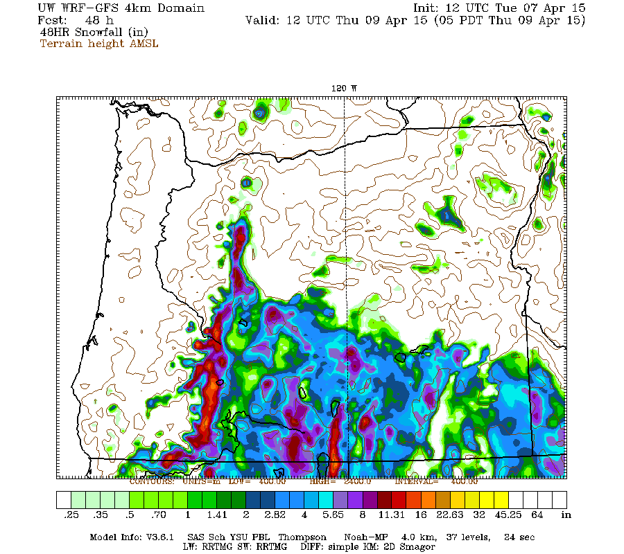
Mount Hood has already picked up 7" new at Timberline Lodge and 5" at Meadows Ski Area in a quick burst Sunday evening as the upper low moved southward off the coast, while Mount Bachelor received 5-8" new and Crater Lake about 9-10" new at Park Headquarters and the Crater Rim the last 2 days. Additional snowfall of up to 1 ft is expected over the southern and Central Oregon Cascades on Tuesday through midday Wednesday, as seen in this plot of 48 hour snowfall through Thursday morning:
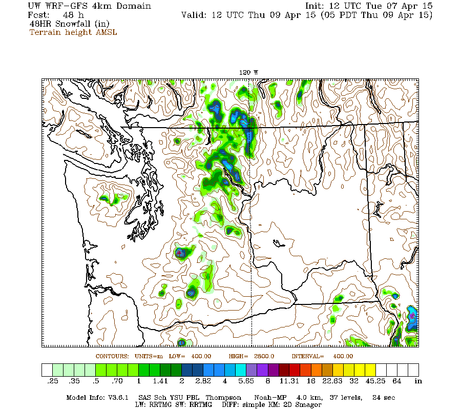
Only a few more inches are expected on Mount Hood and over very scattered parts of the Washington Cascades, mostly on Tuesday:
But fear not, much more snow is coming to Washington shortly, see below!
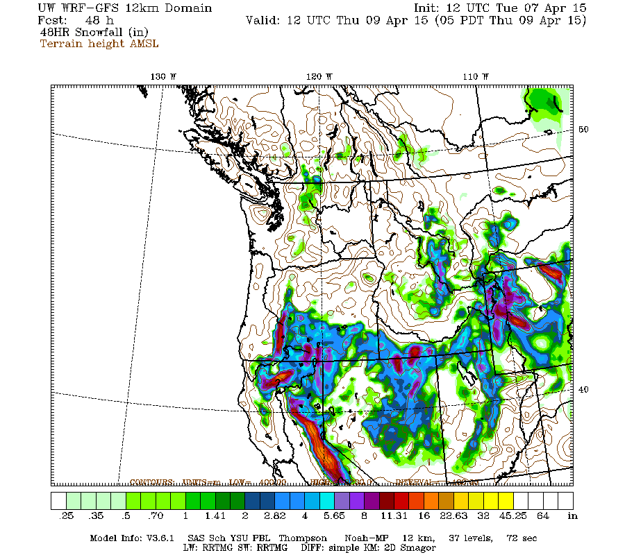
As of Tuesday morning April 7, heavy snowfall has been occurring on Mount Shasta since Monday evening, intensifying greatly after 2am with snowfall rates of 1-2" per hour into late morning. Storm-total snowfall has exceeded 18" already at both the 6750 ft Sand Flat and 7600 ft Old Ski Bowl telemetry sites on Mount Shasta, and heavy snowfall is moving into the Lassen Peak area and the Sierra Nevada for the rest of Tuesday through midday Wednesday, with 1-2 ft expected over much of that region:
Snow levels have plummeted early Tuesday morning to about 1500 ft with accumulating snowfall below 2000 ft along I-5 in the Sacramento River canyon, which carves its way south from Mount Shasta through a rugged eastward projection of the Klamath Mountains. That is even lower than forecast, due to strong evaporative cooling as the intense snow fell into a very dry air mass, a possibility that NWS forecast discussions had mentioned. Here are some views from Caltrans webcams along I-5 showing heavy snowfall extending below 2000 ft on Tuesday morning:
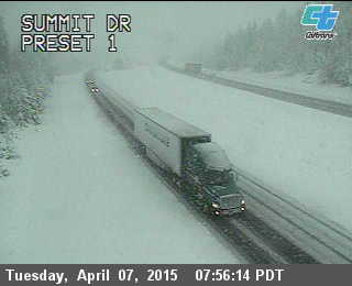
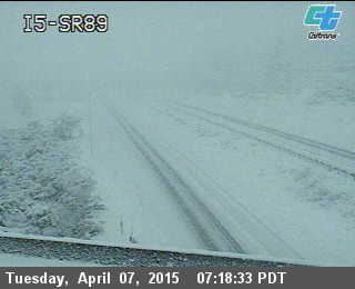
[size=small]I-5 Exit 743, Summit Drive, west flank of Mt Shasta, 3840 ft | I-5 Exit 736, SR 89, SW flank of Mt Shasta, 3530 ft[/size]
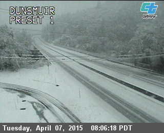
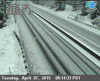
[size=small]I-5 Exit 730, Dunsmuir, SSW of Mt Shasta in Sacramento River canyon, 2420 ft | I-5 Exit 718, Sims Road, SSW of Mt Shasta in Sacramento River canyon, 1820 ft[/size]
But by Thursday, this storm system will be yesterday's news, and the BIG news is expected for this weekend. Here is the story from Tuesday morning's NWAC mountain weather forecast :
The UW model's Tuesday morning run is predicting snowfall amounts of 1-3 ft for the Washington Cascades and southwestern BC from the first system over the weekend, with several inches extending southward into the Oregon Cascades. Here is the 48-hour snowfall through Sunday evening:
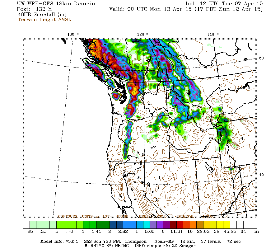
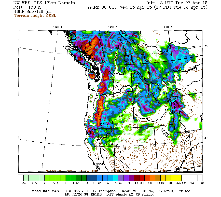
The next system on Monday-Tuesday next week looks comparably strong as of now and aimed a bit farther south at Washington and Oregon, although that's still 6-7 days out and so specifics could possibly change significantly. Here is the snowfall over the subsequent 48-hour period through Tuesday evening April 14, with 1-2 ft for the Washington Cascades and southwestern BC, 1-3 ft for the Oregon Cascades, with several inches extending southward into the California Cascades:
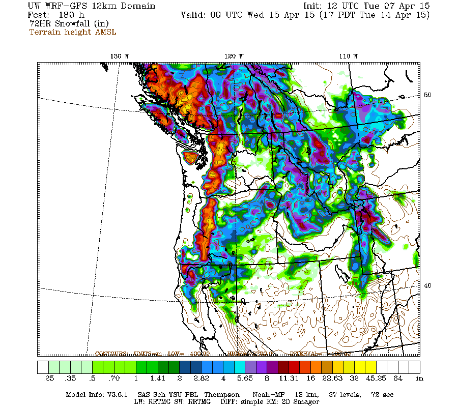
A single 72-hour period can't span both of these systems (we need 96-hour cumulative snowfall graphics from the UW model!), but here is the maximum 72-hour snowfall period currently available through Tuesday evening, with amounts of 1-3 ft for southwestern BC, the Olympics, and the Washington and Oregon Cascades:
Model predictions of these upcoming cold and wet systems have been quite consistent over the last few days, so there is a strong likelihood of the heavy snowfall actually coming true!
Replied by Amar Andalkar on topic Re: 2014-15 Snow Season Summary, April 2015
This is was an excellent and fair report with regards to the year I have dubbed the "Harbinger Pig". ???
Thanks, Gordy. There's an old saying, "When life gives you pigs, it's time to make bacon!" And I've made some excellent bacon throughout this season, including some of my best bacon ever: deep powder on the Cowlitz a few days ago, and an epic February road trip with winter summits and ski descents of the 4 highest peaks in the California Cascades in 5 days, Mount Shasta, Shastina, Lassen Peak, and Brokeoff Mountain, in full sunshine and silky-smooth corn snow -- posted a Facebook micro-TR for that, but never got around to writing a full TR here yet, maybe someday. That trip alone was enough to make this a fine season for me.
I hope that others have been making some bacon this season too. It looks like there were lots of skiers making good bacon this weekend based on recent TRs.
Amar still tried to dress this pig by trying to put a belt on it by saying it was not the worst lift ski season, but it was. Even in the report he then says the other bad one in 2005 did have a decent spring ski season on the lifts, not this year.
We still might have a decent April lift-skiing season, based on current forecasts for heavy snowfall in the Washington and Oregon Cascades over the weekend and into early next week, with snow levels of 2000-3000 ft (see below). Assuming that local ski areas have the ability and desire to reopen for a few weeks if the snow does actually arrive as forecast, as most areas continue to insist on their websites that they are in standby and not closed for the season.
I can already hear the bacon sizzling this weekend and next week!
[hr]Updated Forecast Outlook, 07Apr2015:
For the big Oregon and California snowstorm which is currently underway, more recent model runs (since the last forecast update above 2 days ago) had shifted the timing of the maximum snowfall period about 12 hours later from Monday evening into Tuesday, and had decreased maximum total amounts somewhat into the 2-3 ft range near Mount Shasta, along with decreasing snowfall totals for the Oregon Cascades to 1-2 ft and less than 1 ft for the southern Washington Cascades.
Mount Hood has already picked up 7" new at Timberline Lodge and 5" at Meadows Ski Area in a quick burst Sunday evening as the upper low moved southward off the coast, while Mount Bachelor received 5-8" new and Crater Lake about 9-10" new at Park Headquarters and the Crater Rim the last 2 days. Additional snowfall of up to 1 ft is expected over the southern and Central Oregon Cascades on Tuesday through midday Wednesday, as seen in this plot of 48 hour snowfall through Thursday morning:
Only a few more inches are expected on Mount Hood and over very scattered parts of the Washington Cascades, mostly on Tuesday:
But fear not, much more snow is coming to Washington shortly, see below!
As of Tuesday morning April 7, heavy snowfall has been occurring on Mount Shasta since Monday evening, intensifying greatly after 2am with snowfall rates of 1-2" per hour into late morning. Storm-total snowfall has exceeded 18" already at both the 6750 ft Sand Flat and 7600 ft Old Ski Bowl telemetry sites on Mount Shasta, and heavy snowfall is moving into the Lassen Peak area and the Sierra Nevada for the rest of Tuesday through midday Wednesday, with 1-2 ft expected over much of that region:
Snow levels have plummeted early Tuesday morning to about 1500 ft with accumulating snowfall below 2000 ft along I-5 in the Sacramento River canyon, which carves its way south from Mount Shasta through a rugged eastward projection of the Klamath Mountains. That is even lower than forecast, due to strong evaporative cooling as the intense snow fell into a very dry air mass, a possibility that NWS forecast discussions had mentioned. Here are some views from Caltrans webcams along I-5 showing heavy snowfall extending below 2000 ft on Tuesday morning:
[size=small]I-5 Exit 743, Summit Drive, west flank of Mt Shasta, 3840 ft | I-5 Exit 736, SR 89, SW flank of Mt Shasta, 3530 ft[/size]
[size=small]I-5 Exit 730, Dunsmuir, SSW of Mt Shasta in Sacramento River canyon, 2420 ft | I-5 Exit 718, Sims Road, SSW of Mt Shasta in Sacramento River canyon, 1820 ft[/size]
But by Thursday, this storm system will be yesterday's news, and the BIG news is expected for this weekend. Here is the story from Tuesday morning's NWAC mountain weather forecast :
An upper ridge will begin to move across the area Thursday to maintain fair skies and further gradual warming.
An approaching upper trough offshore and an associated cold front should spread increasing clouds over the area by early Friday with precipitation spreading inland during the afternoon Friday. The moderately strong front, strong for this season, is expected to move quickly across the region Friday night, causing a period of moderate precipitation at rapidly lowering snow levels. Snow levels are expected to lower to near the 2000 foot mark by early Saturday.
Strong westerly flow behind the front should cause significant orographic snowfall along the west slope areas and volcanic peaks Saturday at low snow levels. Showers should continue Saturday night. This looks to be the strongest frontal and orographic combined system in quite some time!
Bonus coverage: Models are showing another relatively strong front with low snow levels for Monday as well.
The UW model's Tuesday morning run is predicting snowfall amounts of 1-3 ft for the Washington Cascades and southwestern BC from the first system over the weekend, with several inches extending southward into the Oregon Cascades. Here is the 48-hour snowfall through Sunday evening:
The next system on Monday-Tuesday next week looks comparably strong as of now and aimed a bit farther south at Washington and Oregon, although that's still 6-7 days out and so specifics could possibly change significantly. Here is the snowfall over the subsequent 48-hour period through Tuesday evening April 14, with 1-2 ft for the Washington Cascades and southwestern BC, 1-3 ft for the Oregon Cascades, with several inches extending southward into the California Cascades:
A single 72-hour period can't span both of these systems (we need 96-hour cumulative snowfall graphics from the UW model!), but here is the maximum 72-hour snowfall period currently available through Tuesday evening, with amounts of 1-3 ft for southwestern BC, the Olympics, and the Washington and Oregon Cascades:
Model predictions of these upcoming cold and wet systems have been quite consistent over the last few days, so there is a strong likelihood of the heavy snowfall actually coming true!
Please Log in or Create an account to join the conversation.
- Amar Andalkar
-
Topic Author
- User
-
Less
More
- Posts: 635
- Thank you received: 0
11 years 3 months ago - 11 years 3 months ago #224369
by Amar Andalkar
Replied by Amar Andalkar on topic Re: 2014-15 Snow Season Summary, April 2015
Afternoon Forecast Outlook Addendum, 07Apr2015:
So it looks like the weather pattern is going to become cold and wet, and therefore very snowy by this weekend and into next week. I thought it might be of interest to some readers to see why this is predicted to happen, for really the first time in 2015 with this intensity, maybe in the entire 2014-15 season including the fall.
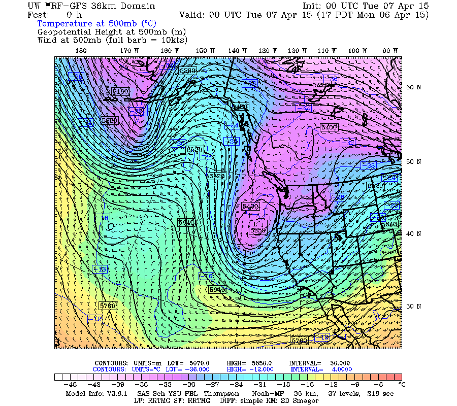
The current closed upper-level low bringing heavy snowfall to southern Oregon and northern California appears to have much to do with that pattern change, as I discovered while taking a more in-depth look through the UW model output now. Here is what yesterday's Monday evening model run showed that the low looked like as of 5pm Monday evening, which looks almost identical to the model prediction from 48 hours earlier (see the same graphic in Reply #1 above):
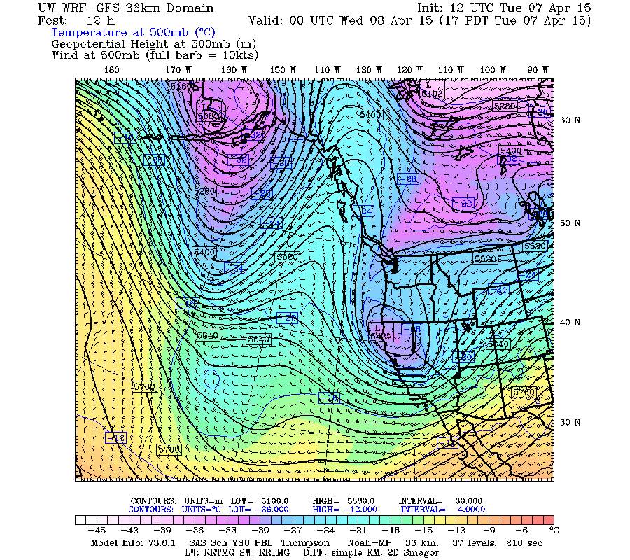
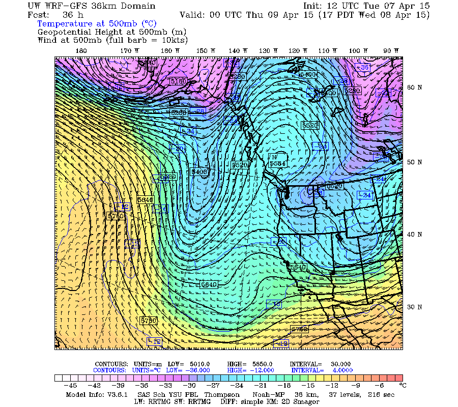
Here is what Tuesday morning's model run predicts that it will look like by 5pm Tuesday evening as it comes ashore on the Oregon-California border:
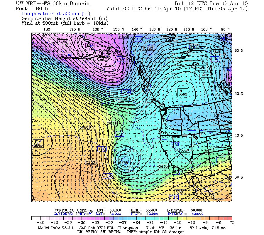
By Wednesday evening, the upper low has moved eastward into the Rockies and almost faded away (its remnant is that slightly-darker blue patch near the Utah-Wyoming-Colorado border). Meanwhile, far out in the Pacific a big lobe of cold upper-level air is sagging far southward, while a weak upper-level ridge aims into the BC coast across Vancouver Island:
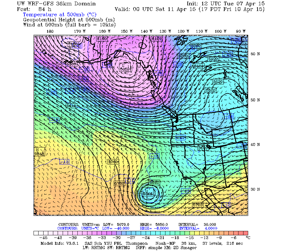
And then the magic happens over the next few hours, as a portion of that lobe pinches off into a beautiful cutoff upper-level low, as seen on Thursday evening, with the weak upper-level ridge still aiming into the coast over the Olympics and towards the Canadian Rockies:
[size=small]Some helpful terminology: a closed upper-level low is a low pressure center with completely closed contour lines encircling it on the 500 mb chart, in contrast to an upper-level trough which is an elongated area of low pressure with no closed contour lines. A cutoff low is a closed low which is detached from the main westerly circulation, the path of the jet stream.[/size]
The cutoff low continues to move southeast on Friday, and meanwhile the weak weak upper-level ridge is vanishing, as seen on Friday evening as the first storm system arrives in the Northwest:
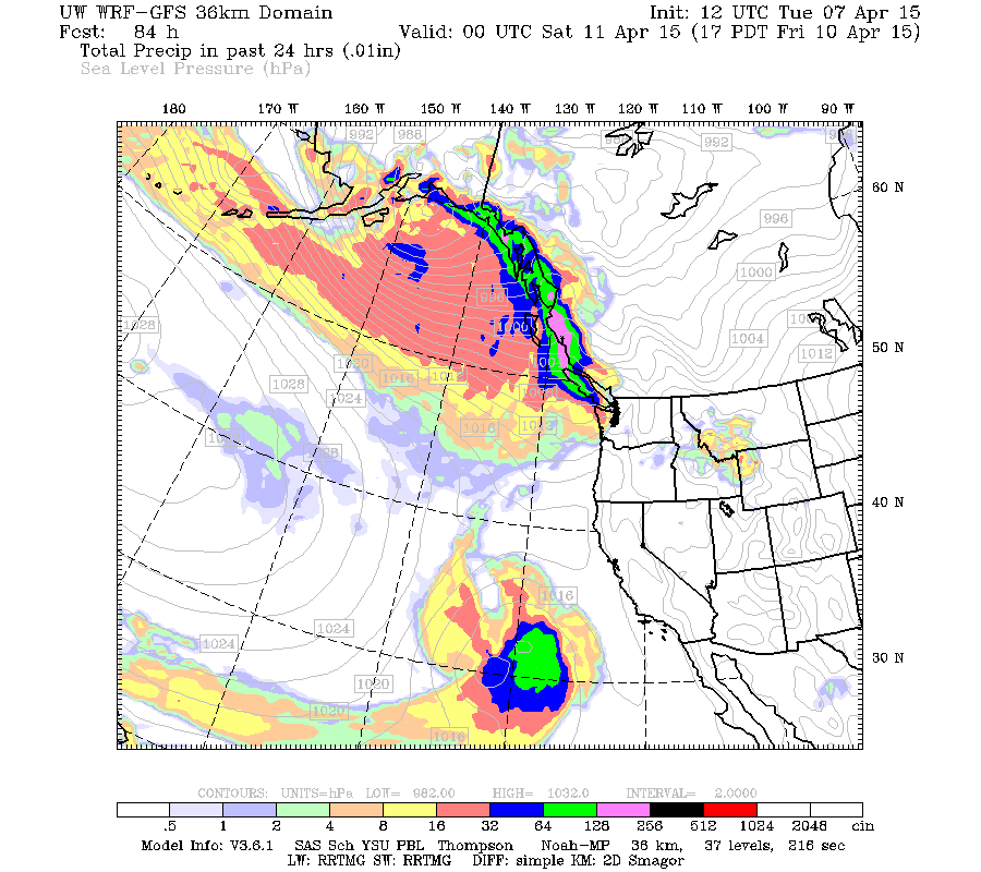
Unfortunately, this cutoff low is way too far off the coast to bring any precip to California, as seen on this 24-hour precip map through Friday evening, with a substantial blob of precip centered where the cutoff low is in the previous image:
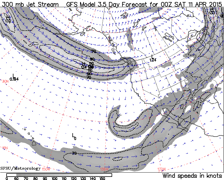
But the magic of this low isn't that it brings water to the rapidly-expanding desert which is California. Its role is to completely eliminate the last chunk of the huge upper-level ridge which has dominated the West Coast's weather for the entire 2014-15 season, bringing untold misery to many Northwest skiers. Here's the GFS prediction of the jet stream at the same time on Friday evening, looking as favorable for Northwest snowfall at low snow levels as it has ever looked in the 2014-15 season:
By Saturday evening, the cutoff low is vanishing to the south, and there is sustained strong westerly and west-northwesterly flow from across the entire North Pacific:
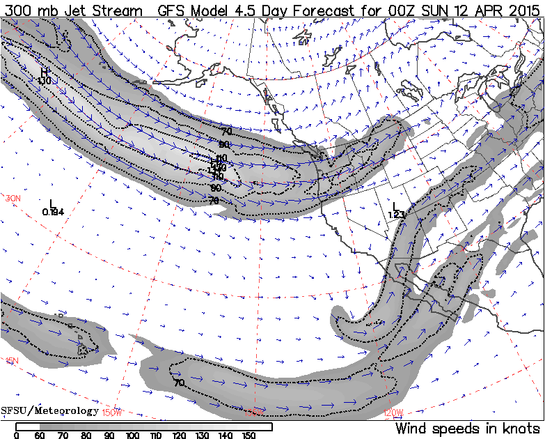
And the jet stream at the same time on Saturday evening, looking even stronger than 24 hours earlier:
The sustained westerly flow (and Northwest snowfall) continues into Sunday evening, when just a hint of what's next can be seen as a small wave in the westerly flow well offshore near 140° W:
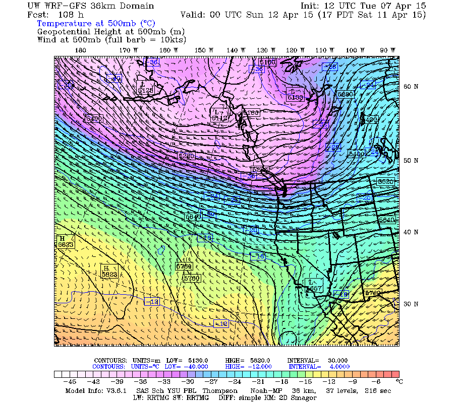
That wave is predicted to develop into a fairly strong upper-level trough which moves ashore on Monday, pulling in more cold air aloft and bringing heavy snowfall to Washington and Oregon. Here is the prediction for Monday evening:
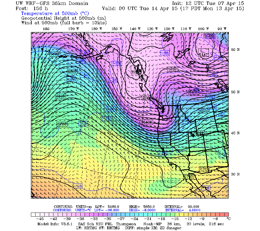
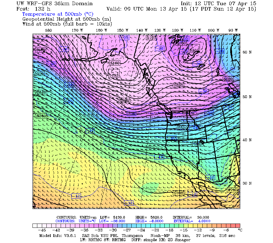
Sustained heavy snowfall is predicted to continue into Tuesday, as the trough digs southeastward and upper-level flow becomes northwesterly:
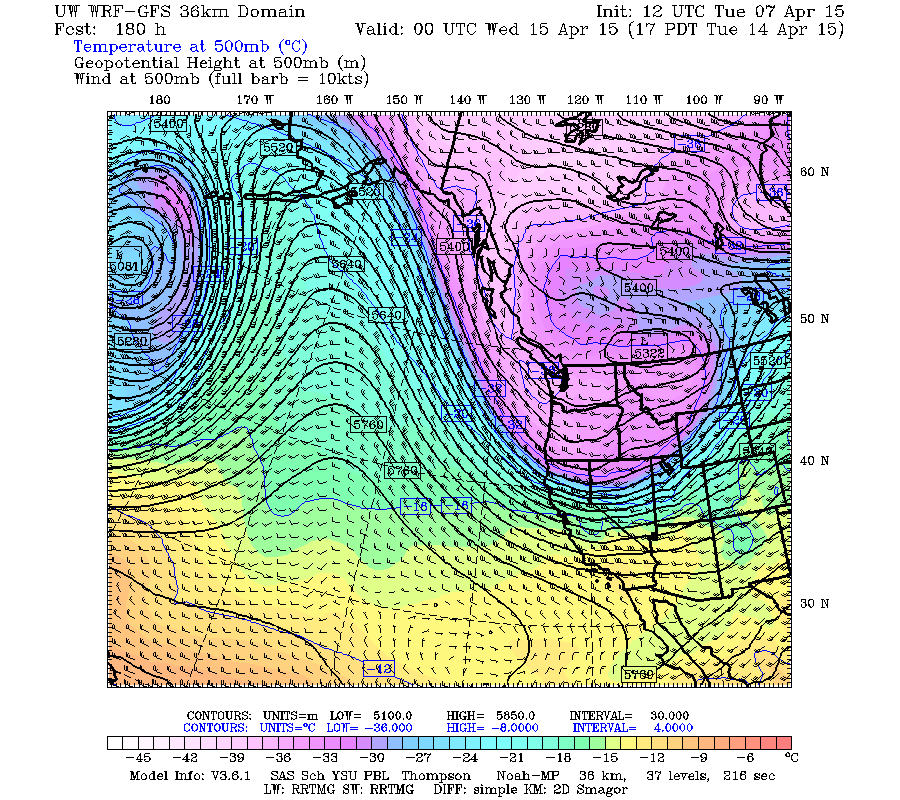
Of course, the details are likely to shift a bit in the latter portion of those predictions 5-7 days out. But I thought it was really interesting how this all works and comes together to produce a major Northwest snowstorm cycle, and figured that it was worth posting about. The Earth's atmosphere and its circulation patterns are beautiful, whether looking at a satellite image or these colorful 500 mb plots.
So it looks like the weather pattern is going to become cold and wet, and therefore very snowy by this weekend and into next week. I thought it might be of interest to some readers to see why this is predicted to happen, for really the first time in 2015 with this intensity, maybe in the entire 2014-15 season including the fall.
The current closed upper-level low bringing heavy snowfall to southern Oregon and northern California appears to have much to do with that pattern change, as I discovered while taking a more in-depth look through the UW model output now. Here is what yesterday's Monday evening model run showed that the low looked like as of 5pm Monday evening, which looks almost identical to the model prediction from 48 hours earlier (see the same graphic in Reply #1 above):
Here is what Tuesday morning's model run predicts that it will look like by 5pm Tuesday evening as it comes ashore on the Oregon-California border:
By Wednesday evening, the upper low has moved eastward into the Rockies and almost faded away (its remnant is that slightly-darker blue patch near the Utah-Wyoming-Colorado border). Meanwhile, far out in the Pacific a big lobe of cold upper-level air is sagging far southward, while a weak upper-level ridge aims into the BC coast across Vancouver Island:
And then the magic happens over the next few hours, as a portion of that lobe pinches off into a beautiful cutoff upper-level low, as seen on Thursday evening, with the weak upper-level ridge still aiming into the coast over the Olympics and towards the Canadian Rockies:
[size=small]Some helpful terminology: a closed upper-level low is a low pressure center with completely closed contour lines encircling it on the 500 mb chart, in contrast to an upper-level trough which is an elongated area of low pressure with no closed contour lines. A cutoff low is a closed low which is detached from the main westerly circulation, the path of the jet stream.[/size]
The cutoff low continues to move southeast on Friday, and meanwhile the weak weak upper-level ridge is vanishing, as seen on Friday evening as the first storm system arrives in the Northwest:
Unfortunately, this cutoff low is way too far off the coast to bring any precip to California, as seen on this 24-hour precip map through Friday evening, with a substantial blob of precip centered where the cutoff low is in the previous image:
But the magic of this low isn't that it brings water to the rapidly-expanding desert which is California. Its role is to completely eliminate the last chunk of the huge upper-level ridge which has dominated the West Coast's weather for the entire 2014-15 season, bringing untold misery to many Northwest skiers. Here's the GFS prediction of the jet stream at the same time on Friday evening, looking as favorable for Northwest snowfall at low snow levels as it has ever looked in the 2014-15 season:
By Saturday evening, the cutoff low is vanishing to the south, and there is sustained strong westerly and west-northwesterly flow from across the entire North Pacific:
And the jet stream at the same time on Saturday evening, looking even stronger than 24 hours earlier:
The sustained westerly flow (and Northwest snowfall) continues into Sunday evening, when just a hint of what's next can be seen as a small wave in the westerly flow well offshore near 140° W:
That wave is predicted to develop into a fairly strong upper-level trough which moves ashore on Monday, pulling in more cold air aloft and bringing heavy snowfall to Washington and Oregon. Here is the prediction for Monday evening:
Sustained heavy snowfall is predicted to continue into Tuesday, as the trough digs southeastward and upper-level flow becomes northwesterly:
Of course, the details are likely to shift a bit in the latter portion of those predictions 5-7 days out. But I thought it was really interesting how this all works and comes together to produce a major Northwest snowstorm cycle, and figured that it was worth posting about. The Earth's atmosphere and its circulation patterns are beautiful, whether looking at a satellite image or these colorful 500 mb plots.
Please Log in or Create an account to join the conversation.
- Floater
-
- User
-
Less
More
- Posts: 23
- Thank you received: 0
11 years 3 months ago #224370
by Floater
Replied by Floater on topic Re: 2014-15 Snow Season Summary, April 2015
Amar it is a bit far off, but like you I got my sights on some Sunday and possibly Monday/Tuesday action. What is great, now days you can watch those meters and then roll to the area where the snow will be most likely the best quality. However, I am not too excited until it materializes......we will see.
I have to admit with the touring gear this late surge in powder has helped us put the "belt" on the pig. One day of hat skiing plus some solid +7s in this year is not bad. Maybe the lifties will get some as well. We can only hope so for the sake of farmers and watersheds.
However, I want to see a string of years where in January everyone is wearing their heavy jackets and goggles due to big dumps rather than me seeing all these women skinning up in halter tops. I want that in April for sure, but not in January. I want winter and walls of snow in Greenwater, Skykomish and at Longmire. That will have me .
.
Keep up the good work and if you keep working at you might become a ghost skier and that has always been hard to do in the PNW...LOL!
I have to admit with the touring gear this late surge in powder has helped us put the "belt" on the pig. One day of hat skiing plus some solid +7s in this year is not bad. Maybe the lifties will get some as well. We can only hope so for the sake of farmers and watersheds.
However, I want to see a string of years where in January everyone is wearing their heavy jackets and goggles due to big dumps rather than me seeing all these women skinning up in halter tops. I want that in April for sure, but not in January. I want winter and walls of snow in Greenwater, Skykomish and at Longmire. That will have me
.Keep up the good work and if you keep working at you might become a ghost skier and that has always been hard to do in the PNW...LOL!
Please Log in or Create an account to join the conversation.
- Jason4
-
- User
-
Less
More
- Posts: 178
- Thank you received: 0
11 years 3 months ago #224372
by Jason4
Replied by Jason4 on topic Re: 2014-15 Snow Season Summary, April 2015
Thank you Amar for the continual optimism and stream of interesting information! I hope I run into you in the mountains sometime to say so in person.
Please Log in or Create an account to join the conversation.