- Posts: 1272
- Thank you received: 0
2014-15 Snow Season Summary, April 2015
- flowing alpy
-

- User
-

Less
More
11 years 3 months ago #224383
by flowing alpy
Replied by flowing alpy on topic Re: 2014-15 Snow Season Summary, April 2015
i'm ok if it fashionable for northern californians to want shasta and lassen be part of the cascade range, if they want.
Please Log in or Create an account to join the conversation.
- Amar Andalkar
-
Topic Author
- User
-
Less
More
- Posts: 635
- Thank you received: 0
11 years 3 months ago - 11 years 3 months ago #224386
by Amar Andalkar
Replied by Amar Andalkar on topic Re: 2014-15 Snow Season Summary, April 2015
No weather updates the last 2 days, I was too busy out skiing powder, unexpectedly good new powder which was a by-product (and also after-effect) of the upper-level low which tracked into the Oregon-California border on Monday-Tuesday. Trip report:
April 8-9, 2015, Rainier, Muir Paradise POWDER x2!
[hr]Updated Forecast Outlook, 10Apr2015:
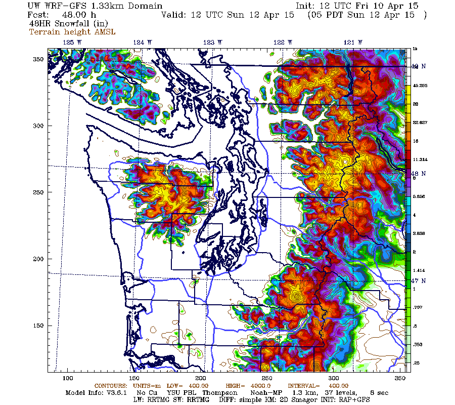
As of Friday afternoon, the very weak upper-level ridge of Wednesday-Thursday is gone, and the first of the two storm systems mentioned in the April 7 update above has reached the Northwest Coast and is pushing inland. The UW model's Friday morning run (72 hours and 6 model runs after the graphics shown above) remains quite consistent with previous runs over the last several days in its snowfall predictions for the Pacific Northwest. A fairly strong cold front will pass through overnight with heavy snowfall, followed by strong westerly flow aloft on Saturday bringing continued snowfall with snow levels in the 2-3000 ft range as predicted all along, lowering to under 2000 ft by Sunday morning as the snowfall ends.
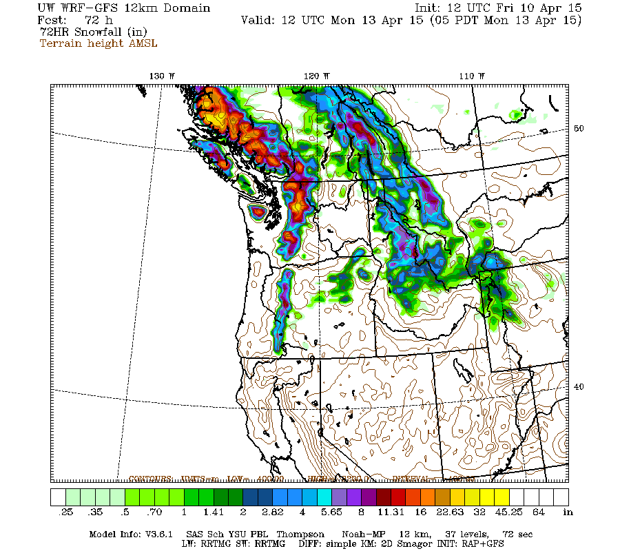
Snowfall amounts of 1-3 ft are predicted to extend through much of southwestern BC, the Olympics, and the Washington Cascades, with lighter amounts of 1-2 ft in the northern Oregon Cascades and only several inches extending into the southern Oregon Cascades. Here is the 72-hour total snowfall through Monday morning April 13, which covers the entire first storm system:
Higher resolution version of that, showing the Pacific Northwest and also zoomed in on Washington and Oregon:
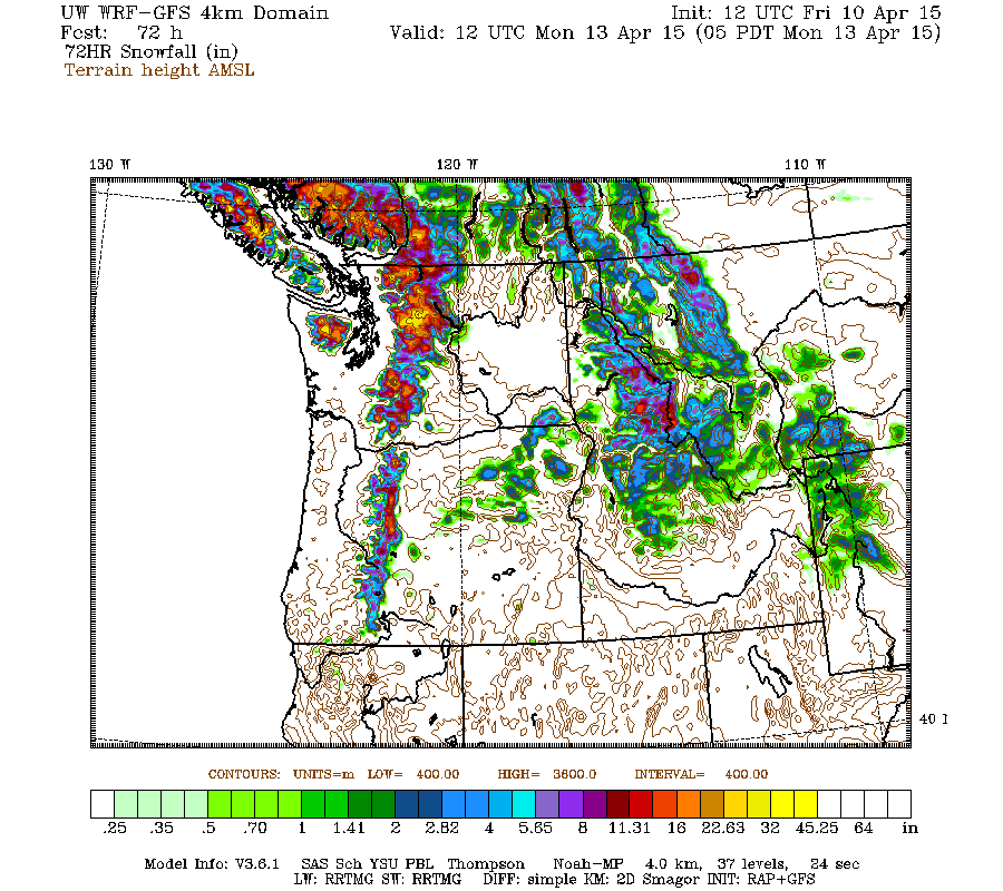
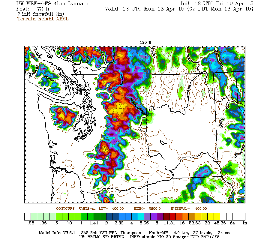
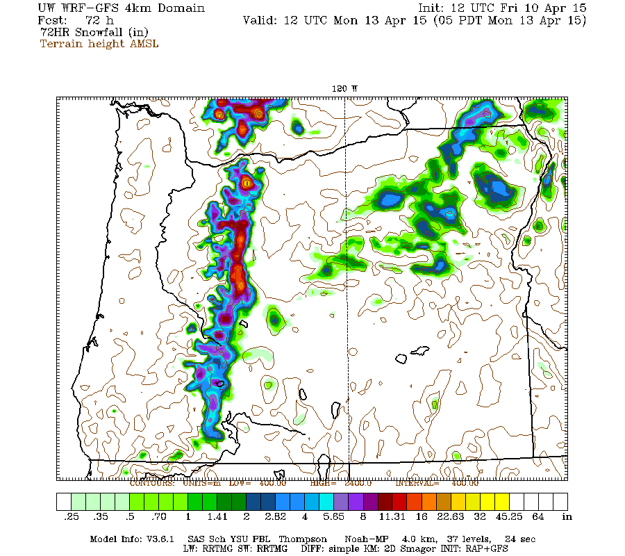
Maximum snowfall amounts of 2-3 ft are shown at higher elevations on Mounts Baker and Rainier, along with the SW slopes of the Olympics and a much larger area of the north-central Cascades including Glacier Peak and perhaps Stevens Pass, where precip will be enhanced by a strong Puget Sound Convergence Zone expected to develop on Saturday. The highest resolution view of this region even shows a maximum of 4+ ft (marked by white inside yellow) on Glacier Peak over the 48-hour period through Sunday morning:
The rest of Sunday will be a break between systems, followed by the next frontal system by midday Monday. Unlike the consistency shown with the first storm system, predictions for the second system have varied considerably in timing, track, and intensity over the last 3-5 days, but eventually seem to be settling somewhere close to what was shown above on April 7, although tracking a bit farther north and thus with less snowfall for the Cascades. Here is the total snowfall over the next 72-hour period through Thursday morning April 16, which covers the entire second storm system which will be over by Tuesday night:
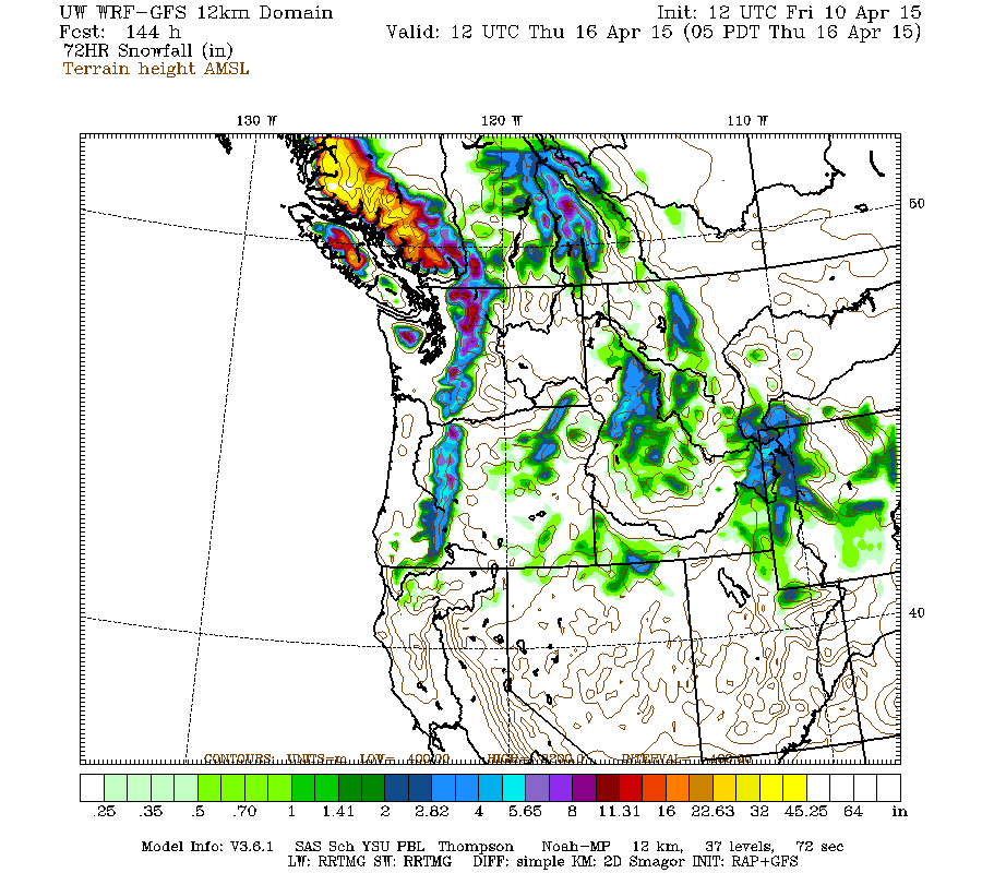
By far the heaviest precip and snowfall from the second system is projected to be along the central BC Coast Mountains, where the snowfall will start earliest on Sunday and end the latest on Wednesday, with 2-4 ft totals shown. Lighter amounts of 1-2 ft are forecast to extend into southwestern BC and the North Cascades, with less than 1 ft farther south and only several inches extending into the Oregon Cascades. Another system aimed at the central BC Coast may bring more snowfall to southwestern BC and the North Cascades next Thursday, although that is too far off to have any confidence, especially with the 2 previous stronger systems yet to develop and pass through.
A ridge of high pressure may bring dry weather for the latter part of next week after that, although that is very uncertain. The extended GFS model out to 384 hours (16 days) shows continued systems and a fairly active weather pattern over the West Coast during the 10-16 day period through April 26, although not as stormy as it has been since March 31 and will be for the next few days. This is the predicted 24-hour precip throughout that period, click "Loop All" to see all the graphics (3 hour intervals up to 240 hours, 12 hour intervals beyond that):
GFS, North Pacific, 04/10/2015 18UTC, precip_p24
April 8-9, 2015, Rainier, Muir Paradise POWDER x2!
[hr]Updated Forecast Outlook, 10Apr2015:
As of Friday afternoon, the very weak upper-level ridge of Wednesday-Thursday is gone, and the first of the two storm systems mentioned in the April 7 update above has reached the Northwest Coast and is pushing inland. The UW model's Friday morning run (72 hours and 6 model runs after the graphics shown above) remains quite consistent with previous runs over the last several days in its snowfall predictions for the Pacific Northwest. A fairly strong cold front will pass through overnight with heavy snowfall, followed by strong westerly flow aloft on Saturday bringing continued snowfall with snow levels in the 2-3000 ft range as predicted all along, lowering to under 2000 ft by Sunday morning as the snowfall ends.
Snowfall amounts of 1-3 ft are predicted to extend through much of southwestern BC, the Olympics, and the Washington Cascades, with lighter amounts of 1-2 ft in the northern Oregon Cascades and only several inches extending into the southern Oregon Cascades. Here is the 72-hour total snowfall through Monday morning April 13, which covers the entire first storm system:
Higher resolution version of that, showing the Pacific Northwest and also zoomed in on Washington and Oregon:
Maximum snowfall amounts of 2-3 ft are shown at higher elevations on Mounts Baker and Rainier, along with the SW slopes of the Olympics and a much larger area of the north-central Cascades including Glacier Peak and perhaps Stevens Pass, where precip will be enhanced by a strong Puget Sound Convergence Zone expected to develop on Saturday. The highest resolution view of this region even shows a maximum of 4+ ft (marked by white inside yellow) on Glacier Peak over the 48-hour period through Sunday morning:
The rest of Sunday will be a break between systems, followed by the next frontal system by midday Monday. Unlike the consistency shown with the first storm system, predictions for the second system have varied considerably in timing, track, and intensity over the last 3-5 days, but eventually seem to be settling somewhere close to what was shown above on April 7, although tracking a bit farther north and thus with less snowfall for the Cascades. Here is the total snowfall over the next 72-hour period through Thursday morning April 16, which covers the entire second storm system which will be over by Tuesday night:
By far the heaviest precip and snowfall from the second system is projected to be along the central BC Coast Mountains, where the snowfall will start earliest on Sunday and end the latest on Wednesday, with 2-4 ft totals shown. Lighter amounts of 1-2 ft are forecast to extend into southwestern BC and the North Cascades, with less than 1 ft farther south and only several inches extending into the Oregon Cascades. Another system aimed at the central BC Coast may bring more snowfall to southwestern BC and the North Cascades next Thursday, although that is too far off to have any confidence, especially with the 2 previous stronger systems yet to develop and pass through.
A ridge of high pressure may bring dry weather for the latter part of next week after that, although that is very uncertain. The extended GFS model out to 384 hours (16 days) shows continued systems and a fairly active weather pattern over the West Coast during the 10-16 day period through April 26, although not as stormy as it has been since March 31 and will be for the next few days. This is the predicted 24-hour precip throughout that period, click "Loop All" to see all the graphics (3 hour intervals up to 240 hours, 12 hour intervals beyond that):
GFS, North Pacific, 04/10/2015 18UTC, precip_p24
Please Log in or Create an account to join the conversation.
- Amar Andalkar
-
Topic Author
- User
-
Less
More
- Posts: 635
- Thank you received: 0
11 years 3 months ago - 11 years 3 months ago #224396
by Amar Andalkar
Replied by Amar Andalkar on topic Re: 2014-15 Snow Season Summary, April 2015
The weekend snowstorm was great, continuing the fine powder conditions of the entire month of April 2015 thus far. Enjoyed excellent powder conditions especially on north-facing terrain near Chinook Pass on Sunday, where we took 2 morning laps on Naches Peak, and then unexpectedly at noon decided to head north to ski the entire traverse to Crystal. Skied 4 more north-facing runs of great powder along the traverse via upper Deadwood Lake and upper Crystal Lake, including skiing all the way out to the base of Crystal Mountain at 4400 ft on barely 4-8" of new snow atop what had been bare ground. We managed to ski and skin the entire route, skinning up on similar amounts of thin new snow atop recently-bare ground on several of the south-facing ascents of the traverse. Big day, and part of our group of 8 took an even bigger and longer variation. Not sure yet if I'll write a full TR.
[hr]Updated Forecast Outlook, 13Apr2015:
The first storm system of the new winter-like, westerly-flow pattern over the weekend brought snowfall amounts of 1-2 ft to favored areas of the Olympics and Washington Cascades, with lesser amounts well under 1 ft in the Oregon Cascades. That is well within the range of amounts expected from the forecasts, although perhaps below the middle of that range. Probably the largest new snow total at any telemetry site over the 2-day period was over 24" new (and a 5" increase in SWE!) at Easy Pass SNOTEL at 5270 ft in the North Cascades, although sadly the snowdepth sensor has been very flaky there, and is reading about 40" too low at this time as verified by manual measurement on April 5. Other large totals included over 20" new at Brown Top SNOTEL (5830 ft) and Mount Baker Ski Area (4200 ft), 19" at Mount Rainier Paradise (5400 ft), 18" at Stevens Pass (3950 ft), and over 16" new at Chinook Pass (5500 ft) and at Buckinghorse SNOTEL (4870 ft) in the Olympics.
Unfortunately there are no snow telemetry sites in the region north of Stevens Pass to Glacier Peak and west of the Crest, where the UW model indicated the maximum convergence-zone-enhanced snowfall amounts of 2-4 ft from this storm. Lyman Lake SNOTEL site (5980 ft) just east of the Crest at the north margin of the convergence region got about 1 ft. The storm was a real bust for Snoqualmie Pass which got almost no snow at pass level. During the early frontal part of the storm, precip amounts were fairly light at Snoqualmie but fell as rain there, while after snow levels dropped below 3000 ft in the post-frontal phase there was little precip directed there, and the convergence zone remained well to the north as forecast.
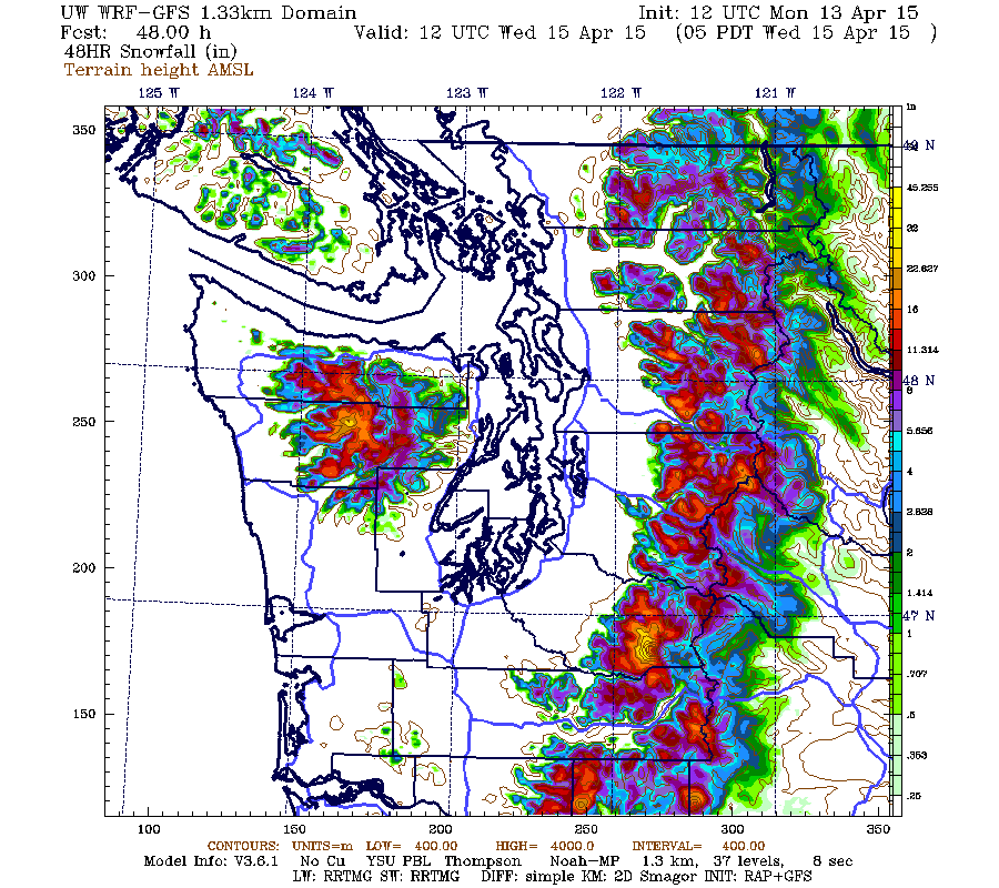
As of Monday morning, the 2nd storm system of this cycle has already reached the Washington Coast and is moving inland. Snowfall amounts of up to 1-2 ft are predicted to extend from southwestern BC through the length of the Washington and Oregon Cascades. Here is the 48-hour total snowfall through Wednesday morning April 15, which covers the entire 2nd storm system:
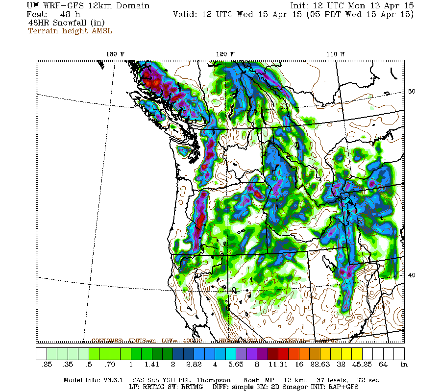
Higher resolution version of that, showing the Pacific Northwest and also zoomed in on Washington and Oregon:
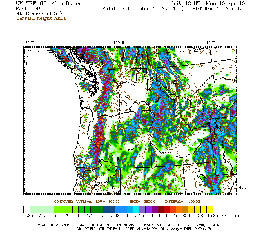
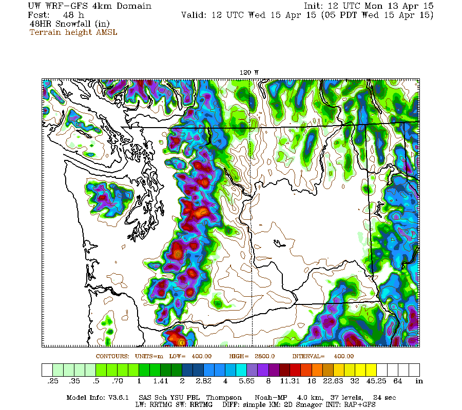
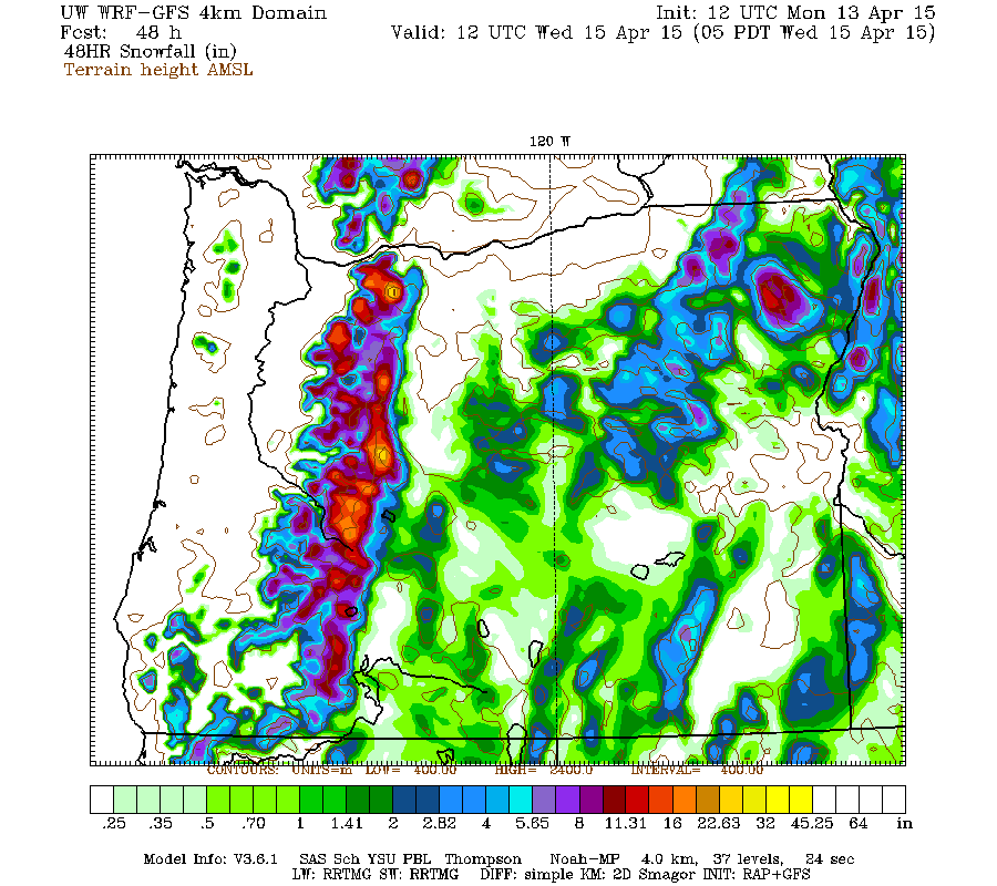
The latest model runs have been leaning towards more snow in the Oregon Cascades than the Washington Cascades. Maximum snowfall amounts of 1.5-2 ft are shown at higher elevations on Mount Hood and the Three Sisters, with amounts over 1 ft predicted at a number of other locations including Mounts Rainier and Jefferson, and near Diamond Peak. The highest resolution view of western Washington even shows a maximum of 2 ft on the westerly slopes of Mount Rainier over that 48-hour period:
So the upcoming April 15 NWAC climatological snowdepth table should look quite a bit better than the April 1 version at almost all of its sites, except Snoqualmie and Mission Ridge.
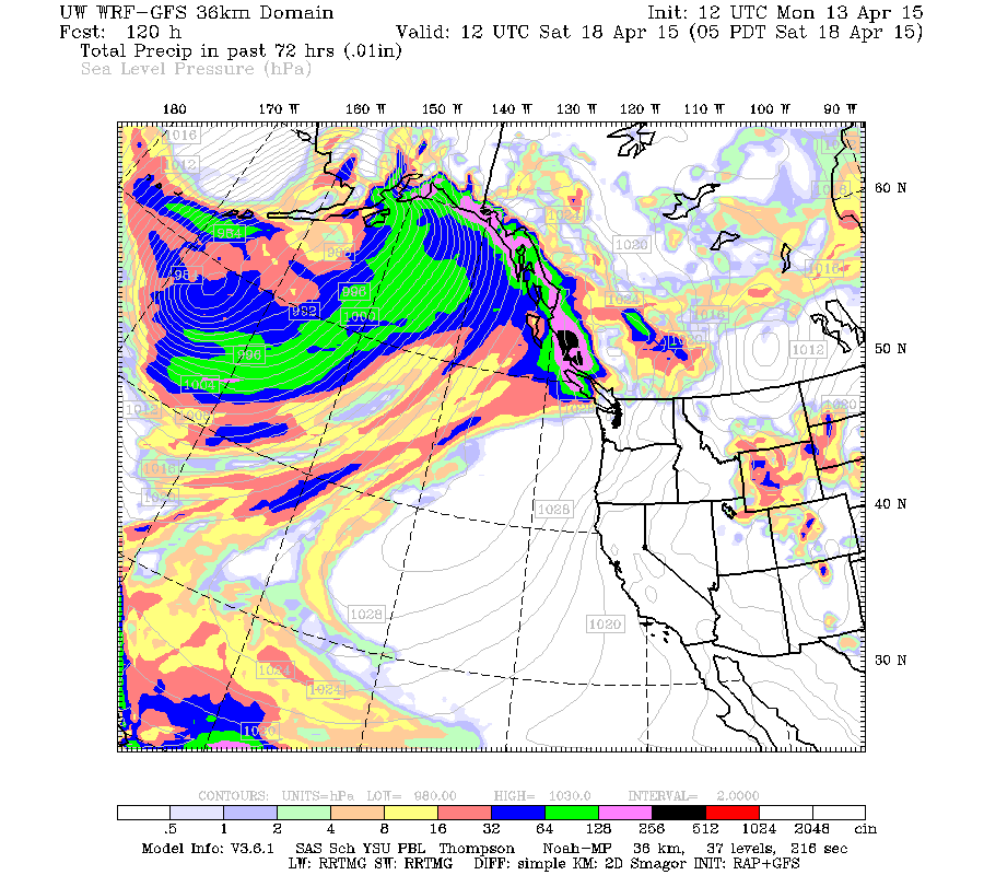
High pressure builds on Wednesday, ending the nice westerly-flow pattern aimed straight across the North Pacific into the Northwest after less than a week. Great to see that pattern at least once in 2015, and sweet while it lasted. The next system is directed well to the north into southeast Alaska and the central BC coast, with dry conditions in Washington, Oregon, and California as seen in the precip map for the next 72-hour period through Saturday morning April 18:
A similar situation is expected through the weekend, with the next system heading even farther north into south-central Alaska as seen in the precip map through Monday evening:
The extended GFS model out to 384 hours (16 days) shows additional storm systems and a fairly active weather pattern over the West Coast during the 9-16 day period from Wednesday April 22 through April 29, although that's still a long way off and subject to major changes. This is the predicted 24-hour precip throughout that period, click "Loop All" to see all the graphics (3 hour intervals up to 240 hours, 12 hour intervals beyond that):
GFS, North Pacific, 04/13/2015 12UTC, precip_p24
[hr]Updated Forecast Outlook, 13Apr2015:
The first storm system of the new winter-like, westerly-flow pattern over the weekend brought snowfall amounts of 1-2 ft to favored areas of the Olympics and Washington Cascades, with lesser amounts well under 1 ft in the Oregon Cascades. That is well within the range of amounts expected from the forecasts, although perhaps below the middle of that range. Probably the largest new snow total at any telemetry site over the 2-day period was over 24" new (and a 5" increase in SWE!) at Easy Pass SNOTEL at 5270 ft in the North Cascades, although sadly the snowdepth sensor has been very flaky there, and is reading about 40" too low at this time as verified by manual measurement on April 5. Other large totals included over 20" new at Brown Top SNOTEL (5830 ft) and Mount Baker Ski Area (4200 ft), 19" at Mount Rainier Paradise (5400 ft), 18" at Stevens Pass (3950 ft), and over 16" new at Chinook Pass (5500 ft) and at Buckinghorse SNOTEL (4870 ft) in the Olympics.
Unfortunately there are no snow telemetry sites in the region north of Stevens Pass to Glacier Peak and west of the Crest, where the UW model indicated the maximum convergence-zone-enhanced snowfall amounts of 2-4 ft from this storm. Lyman Lake SNOTEL site (5980 ft) just east of the Crest at the north margin of the convergence region got about 1 ft. The storm was a real bust for Snoqualmie Pass which got almost no snow at pass level. During the early frontal part of the storm, precip amounts were fairly light at Snoqualmie but fell as rain there, while after snow levels dropped below 3000 ft in the post-frontal phase there was little precip directed there, and the convergence zone remained well to the north as forecast.
As of Monday morning, the 2nd storm system of this cycle has already reached the Washington Coast and is moving inland. Snowfall amounts of up to 1-2 ft are predicted to extend from southwestern BC through the length of the Washington and Oregon Cascades. Here is the 48-hour total snowfall through Wednesday morning April 15, which covers the entire 2nd storm system:
Higher resolution version of that, showing the Pacific Northwest and also zoomed in on Washington and Oregon:
The latest model runs have been leaning towards more snow in the Oregon Cascades than the Washington Cascades. Maximum snowfall amounts of 1.5-2 ft are shown at higher elevations on Mount Hood and the Three Sisters, with amounts over 1 ft predicted at a number of other locations including Mounts Rainier and Jefferson, and near Diamond Peak. The highest resolution view of western Washington even shows a maximum of 2 ft on the westerly slopes of Mount Rainier over that 48-hour period:
So the upcoming April 15 NWAC climatological snowdepth table should look quite a bit better than the April 1 version at almost all of its sites, except Snoqualmie and Mission Ridge.
High pressure builds on Wednesday, ending the nice westerly-flow pattern aimed straight across the North Pacific into the Northwest after less than a week. Great to see that pattern at least once in 2015, and sweet while it lasted. The next system is directed well to the north into southeast Alaska and the central BC coast, with dry conditions in Washington, Oregon, and California as seen in the precip map for the next 72-hour period through Saturday morning April 18:
A similar situation is expected through the weekend, with the next system heading even farther north into south-central Alaska as seen in the precip map through Monday evening:
The extended GFS model out to 384 hours (16 days) shows additional storm systems and a fairly active weather pattern over the West Coast during the 9-16 day period from Wednesday April 22 through April 29, although that's still a long way off and subject to major changes. This is the predicted 24-hour precip throughout that period, click "Loop All" to see all the graphics (3 hour intervals up to 240 hours, 12 hour intervals beyond that):
GFS, North Pacific, 04/13/2015 12UTC, precip_p24
Please Log in or Create an account to join the conversation.
- Floater
-
- User
-
Less
More
- Posts: 23
- Thank you received: 0
11 years 3 months ago #224400
by Floater
Replied by Floater on topic Re: 2014-15 Snow Season Summary, April 2015
Amar - We had an easier day of it one person with us was just learning the ropes. We had great pow in the morning and decent turns even in the after noon. Yes we were all smiling no halter tops!
Mike knows where to go to avoid the people. You just have to be willing to go out a bit further. Yes, those having backcountry equipment and not stuck in the resort are being able to get some decent pow here in April.
Tues/Wed are the next good days then it is warming up and a high is settling in. Do you have a bicycle? If you do give me a post on my email.
Please Log in or Create an account to join the conversation.
- DG
-
- User
-
Less
More
- Posts: 150
- Thank you received: 0
11 years 3 months ago #224402
by DG
Replied by DG on topic Re: 2014-15 Snow Season Summary, April 2015
Thanks Amar for the stellar reporting, as always! Seems like the alpine snowpack is in place for a decent spring touring season in the Cascades.
Please Log in or Create an account to join the conversation.
- Floater
-
- User
-
Less
More
- Posts: 23
- Thank you received: 0
11 years 3 months ago #224414
by Floater
Replied by Floater on topic Re: 2014-15 Snow Season Summary, April 2015
Well Amar I think the big action of the Harbinger Pig is over. However, I have skied super pow on Cinco de Mayo. Paradise glacier was decent today, but that will all be cooked tomorrow.
It is great this touring gear. You can take the worst ski season on record and kick it up a few notches and get some pow. Yep dress that pig and that is what you and I did these last few days.
Why the word "harbinger". I think Cliff Mass says it all and there is not a lot of room on those high volcanoes for all of us. However today we were the only ones out on the Paradise GL. making lovely turns from the top of it to the bottom and out via Mazama Ridge.
cliffmass.blogspot.com/2015/02/the-winter-of-2070.html
No we are screwed, but I am 66 so I only need to milk about ten more years of decent action.
Oh and for the rest of the year go high and ski corn....
cliffmass.blogspot.com/
If you were a resort skier on average this was the worst with most Washington ski areas having snow depths at record lows or tied for record lows.
You do a good job reporting and also a great job trying to dress this pig, but remember you can't make a silk purse out of sow's ear.........
Please Log in or Create an account to join the conversation.