- Posts: 635
- Thank you received: 0
New storm cycle with 4-8 ft snow Feb26-Mar10,2014!
- Amar Andalkar
-
 Topic Author
- User
-

Less
More
12 years 3 months ago - 12 years 3 months ago #221050
by Amar Andalkar
Replied by Amar Andalkar on topic Re: New storm cycle with 4-8 ft snow Feb26-Mar8,2014!
Update #2: 72 hours after initial post, 2-5 ft of snow has already fallen from southwestern BC to California,
with an additional 4-8 ft (or more) predicted over the next week for southwestern BC, Washington, and Oregon!
Just a brief update, during a nice lull between storm systems on Wednesday, following very heavy precip overnight into Wednesday morning, and before even heavier precip arrives on Wednesday evening. Significant snowfall overnight was only recorded at the highest measurement sites in the North Cascades and BC Cascades above 4000-5000 ft with about 6-12" new, but farther northwest in BC snowfall occurred down to below 1000 ft between Whistler and Squamish.
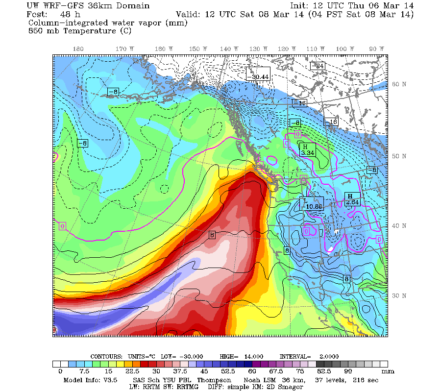
Another day later, and 2 more subsequent runs of the UW WRF-GFS model at 12-hour intervals continue to predict very large precip and snowfall amounts, although the highest snowfall amounts will still occur only at higher elevations due to strong southwesterly flow during the wettest parts of the upcoming systems. The storm cycle still appears likely to continue through next Tuesday.
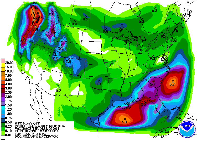
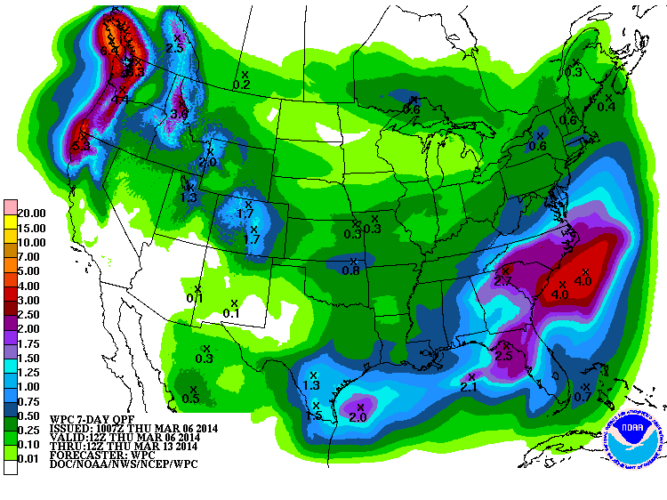
The NWS's GFS model and their Quantitative Precipitation Forecasts are showing up to 5-9" of additional precip over the next week for the mountains of southwestern BC, Washington, Oregon, and northern California, with about 1-2" extending south into the northern Sierra Nevada. Here is total precipitation in inches predicted over the next 7 days through the afternoon of Wednesday March 12:
The next strong system arrives shortly on Wednesday evening, with its trailing cold front on early Thursday, and subsequent post-frontal showers should extend into Friday morning. Snow levels tonight are still expected to be 6000-7000 ft in most of the Washington and Oregon Cascades, but perhaps 5000 ft in the North Cascades and 4000 ft in southwestern BC. They are still expected to drop significantly by Thursday morning and even further by Thursday evening to around 3000-4000 ft.
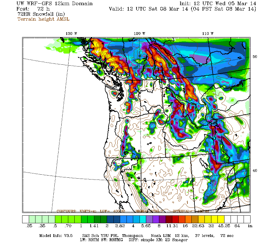
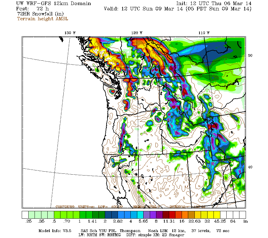
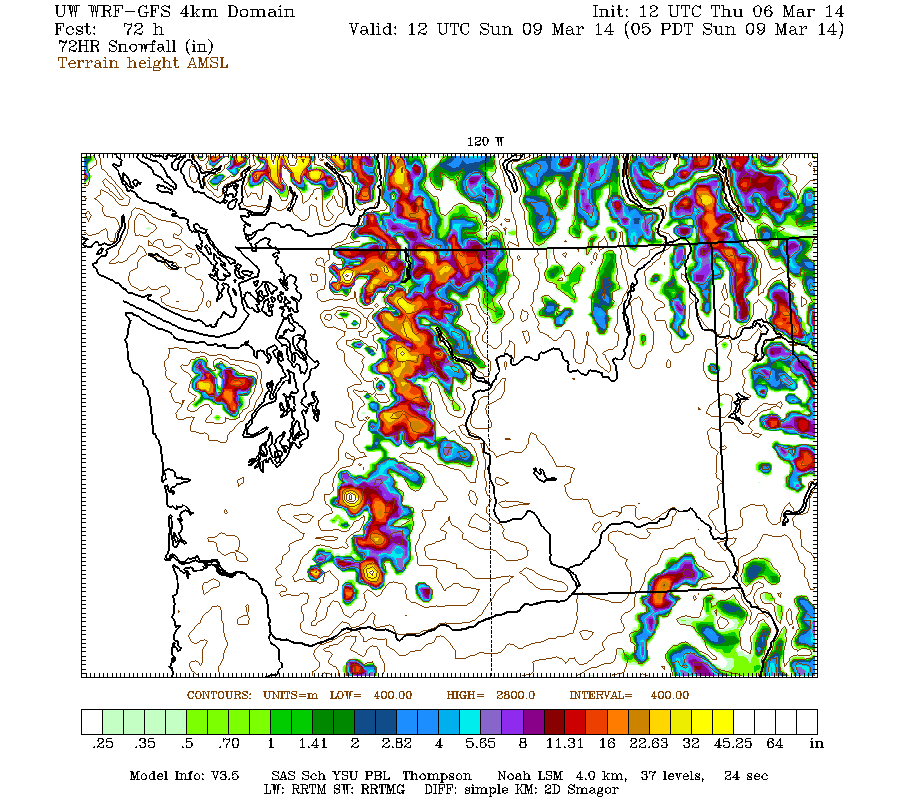
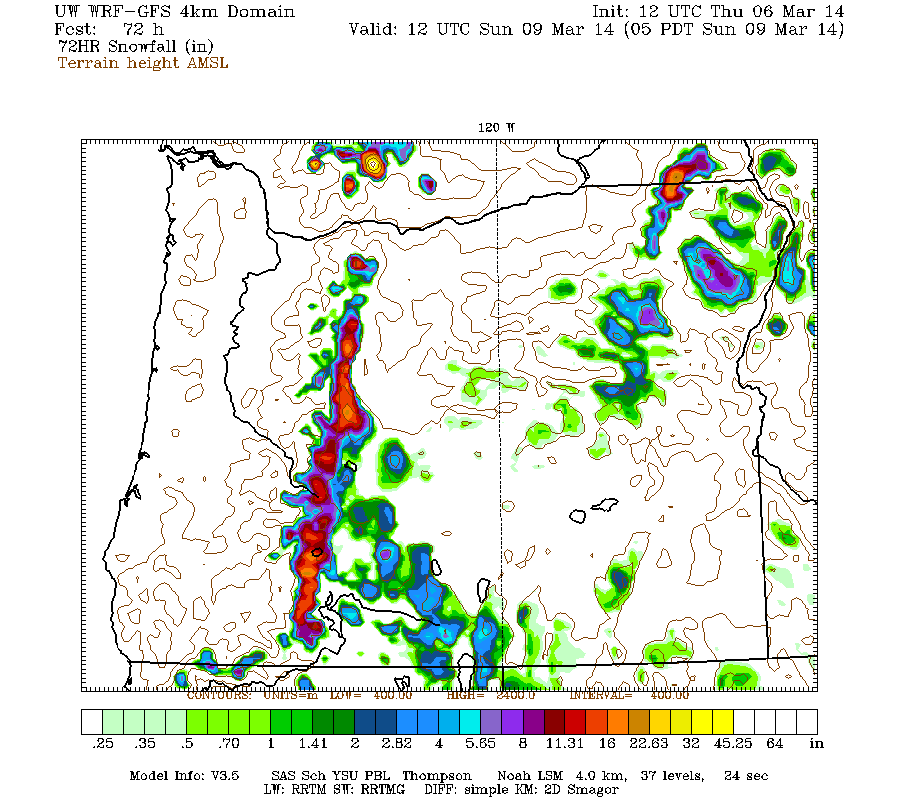
Snowfall during the next 3 days through 4am Saturday is predicted to be 2-7 ft over southwestern BC and the Washington Cascades, around 1-4 ft over the Olympics and Oregon Cascades, with perhaps 1-3 ft extending as far south as Mount Shasta and 1 ft extending into the Sierra Nevada:
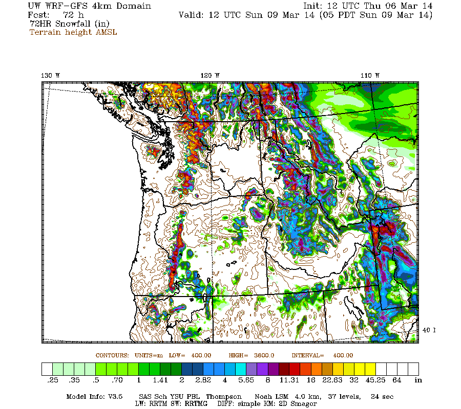
Higher resolution version of that, showing the Pacific Northwest and also zoomed in on Washington and Oregon:
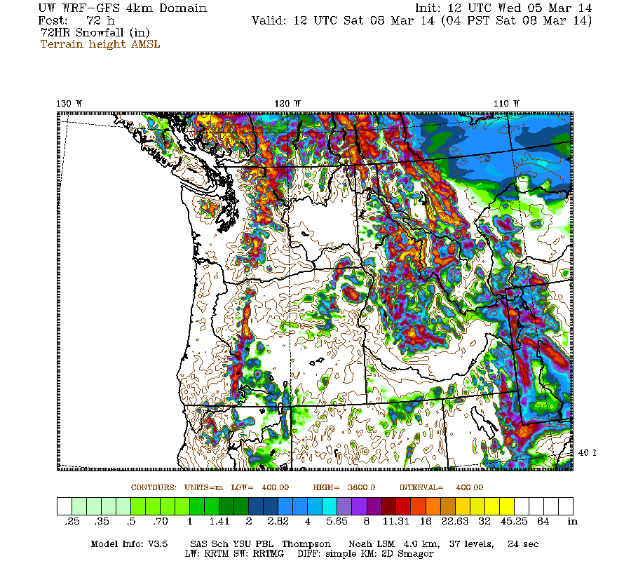
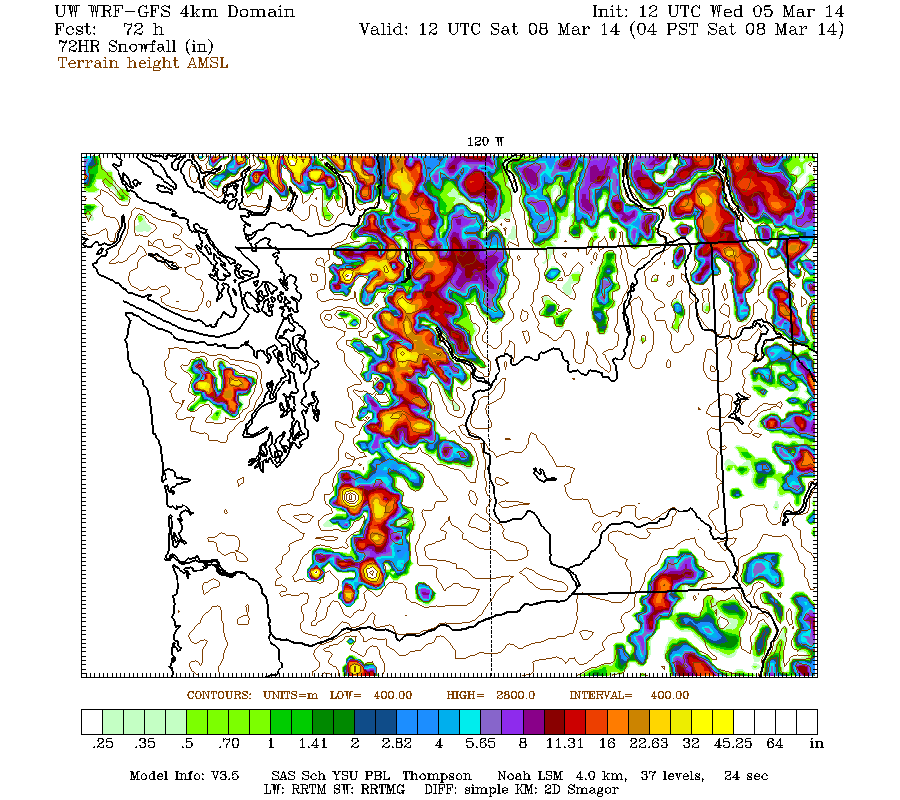
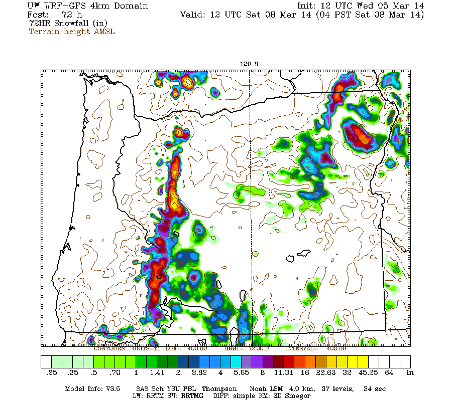
Maximum snowfall amounts of 4-7 ft (marked by white inside yellow) are shown over parts of southwestern BC and the volcanic peaks of the Washington Cascades. The most intense period of snowfall is still expected Thursday through early Friday, and although 24-hour totals have diminished from yesterday's runs they are still predicted to be 2-3 ft on Mounts Baker, Rainier, Adams, and Saint Helens above about 5000-6000 ft.
This loop shows how the model predictions for snowfall during the 3-day period through 4am Saturday have evolved between 10 subsequent runs over the last 5 days, the D(model)/D(t). Very consistent in the overall picture, with ongoing variation in amounts:
www.atmos.washington.edu/~ovens/wxloop.c...2+v2014030812///+-st
There is still expected to be a major lull in precipitation from Friday evening through Saturday for Oregon and Washington, as a transient weak ridge pushes the next incoming system northward towards the central BC coast and Vancouver Island. Eventually that system and its associated atmospheric river shift southward over Washington and Oregon by late Saturday. That weekend system is currently predicted to have even higher snow levels than the one on Wednesday (perhaps 7000-8000 ft), but not quite as much precip either. In any case, snowfall over the weekend will once again be limited to higher elevations only.
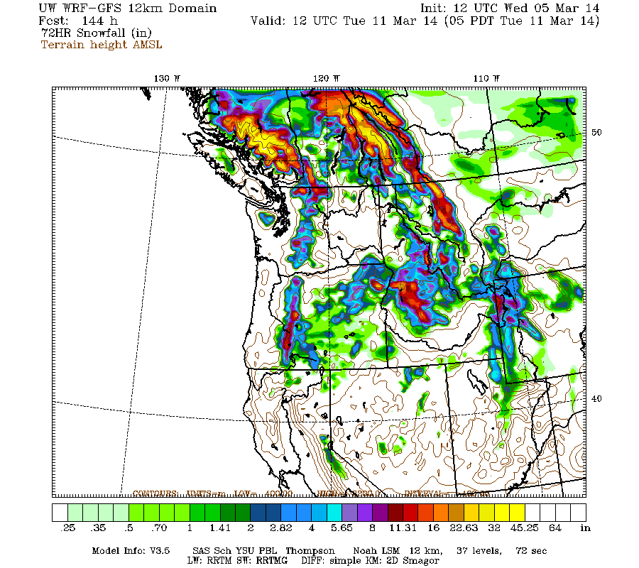
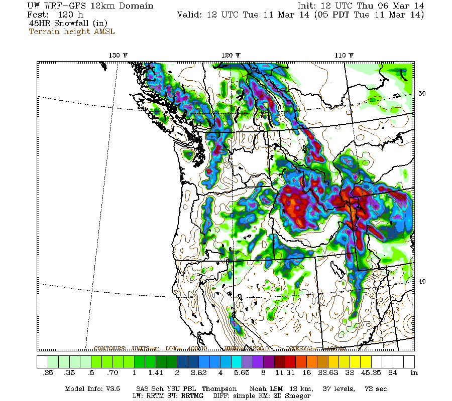
Another system on Monday into Tuesday looks almost certain now, with more reasonable snow levels, and with snowfall now likely to extend through Oregon too. Additional snowfall during the subsequent 3 days ending 5am (PDT already!) next Tuesday is predicted to be 2-4 ft over southwestern BC, with 1-2 ft in the Washington and Oregon Cascades:
The D(model)/D(t) for that 3-day period has changed significantly despite only 4 model runs so far extending out to that period. Precipitation has shifted southward with each subsequent model run, greatly increasing predicted snowfall in Oregon:
www.atmos.washington.edu/~ovens/wxloop.c...2+v2014031112///+-st
Details of that system will likely continue to change as that period draws closer, as it is still 5-6 days out, near the limit of accurate numerical weather prediction, especially given that the evolution of the very strong system on Wednesday will have a significant effect on the development of the subsequent systems, and on upcoming model predictions.
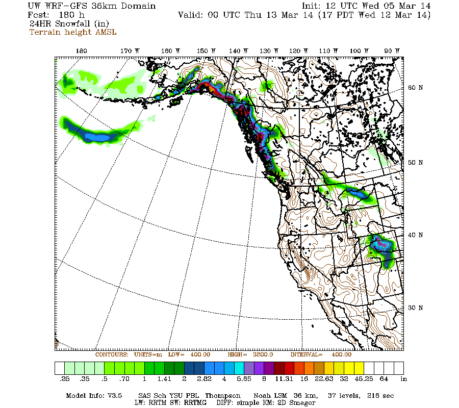
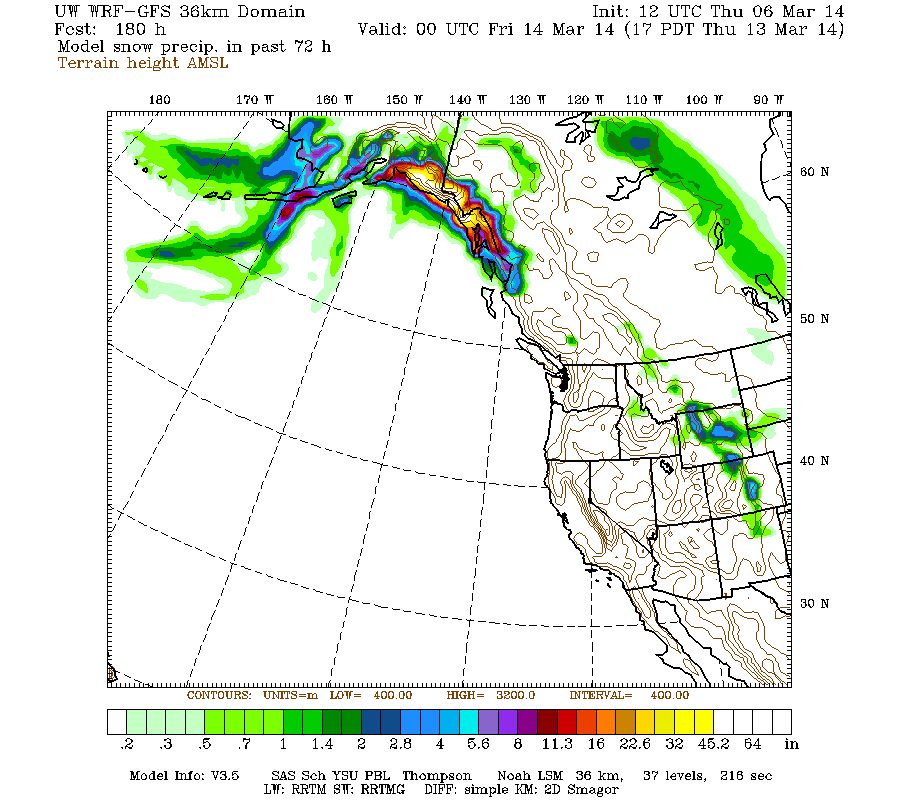
Beyond Tuesday, it currently appears as though this storm cycle is likely to come to an end, with a moderate ridge of high pressure building over the West Coast during the middle of next week, and a new storm cycle developing with heavy precip and snowfall primarily over south-central and southeast Alaska. Here is a broad overview showing 24-hour snowfall through 5pm next Wednesday, with nothing over Washington/Oregon and 1-3 ft predicted in parts of Alaska:
with an additional 4-8 ft (or more) predicted over the next week for southwestern BC, Washington, and Oregon!
Just a brief update, during a nice lull between storm systems on Wednesday, following very heavy precip overnight into Wednesday morning, and before even heavier precip arrives on Wednesday evening. Significant snowfall overnight was only recorded at the highest measurement sites in the North Cascades and BC Cascades above 4000-5000 ft with about 6-12" new, but farther northwest in BC snowfall occurred down to below 1000 ft between Whistler and Squamish.
Another day later, and 2 more subsequent runs of the UW WRF-GFS model at 12-hour intervals continue to predict very large precip and snowfall amounts, although the highest snowfall amounts will still occur only at higher elevations due to strong southwesterly flow during the wettest parts of the upcoming systems. The storm cycle still appears likely to continue through next Tuesday.
The NWS's GFS model and their Quantitative Precipitation Forecasts are showing up to 5-9" of additional precip over the next week for the mountains of southwestern BC, Washington, Oregon, and northern California, with about 1-2" extending south into the northern Sierra Nevada. Here is total precipitation in inches predicted over the next 7 days through the afternoon of Wednesday March 12:
The next strong system arrives shortly on Wednesday evening, with its trailing cold front on early Thursday, and subsequent post-frontal showers should extend into Friday morning. Snow levels tonight are still expected to be 6000-7000 ft in most of the Washington and Oregon Cascades, but perhaps 5000 ft in the North Cascades and 4000 ft in southwestern BC. They are still expected to drop significantly by Thursday morning and even further by Thursday evening to around 3000-4000 ft.
Snowfall during the next 3 days through 4am Saturday is predicted to be 2-7 ft over southwestern BC and the Washington Cascades, around 1-4 ft over the Olympics and Oregon Cascades, with perhaps 1-3 ft extending as far south as Mount Shasta and 1 ft extending into the Sierra Nevada:
Higher resolution version of that, showing the Pacific Northwest and also zoomed in on Washington and Oregon:
Maximum snowfall amounts of 4-7 ft (marked by white inside yellow) are shown over parts of southwestern BC and the volcanic peaks of the Washington Cascades. The most intense period of snowfall is still expected Thursday through early Friday, and although 24-hour totals have diminished from yesterday's runs they are still predicted to be 2-3 ft on Mounts Baker, Rainier, Adams, and Saint Helens above about 5000-6000 ft.
This loop shows how the model predictions for snowfall during the 3-day period through 4am Saturday have evolved between 10 subsequent runs over the last 5 days, the D(model)/D(t). Very consistent in the overall picture, with ongoing variation in amounts:
www.atmos.washington.edu/~ovens/wxloop.c...2+v2014030812///+-st
There is still expected to be a major lull in precipitation from Friday evening through Saturday for Oregon and Washington, as a transient weak ridge pushes the next incoming system northward towards the central BC coast and Vancouver Island. Eventually that system and its associated atmospheric river shift southward over Washington and Oregon by late Saturday. That weekend system is currently predicted to have even higher snow levels than the one on Wednesday (perhaps 7000-8000 ft), but not quite as much precip either. In any case, snowfall over the weekend will once again be limited to higher elevations only.
Another system on Monday into Tuesday looks almost certain now, with more reasonable snow levels, and with snowfall now likely to extend through Oregon too. Additional snowfall during the subsequent 3 days ending 5am (PDT already!) next Tuesday is predicted to be 2-4 ft over southwestern BC, with 1-2 ft in the Washington and Oregon Cascades:
The D(model)/D(t) for that 3-day period has changed significantly despite only 4 model runs so far extending out to that period. Precipitation has shifted southward with each subsequent model run, greatly increasing predicted snowfall in Oregon:
www.atmos.washington.edu/~ovens/wxloop.c...2+v2014031112///+-st
Details of that system will likely continue to change as that period draws closer, as it is still 5-6 days out, near the limit of accurate numerical weather prediction, especially given that the evolution of the very strong system on Wednesday will have a significant effect on the development of the subsequent systems, and on upcoming model predictions.
Beyond Tuesday, it currently appears as though this storm cycle is likely to come to an end, with a moderate ridge of high pressure building over the West Coast during the middle of next week, and a new storm cycle developing with heavy precip and snowfall primarily over south-central and southeast Alaska. Here is a broad overview showing 24-hour snowfall through 5pm next Wednesday, with nothing over Washington/Oregon and 1-3 ft predicted in parts of Alaska:
Please Log in or Create an account to join the conversation.
- DendriteSupertramp
-
- User
-
Less
More
- Posts: 25
- Thank you received: 0
12 years 3 months ago #221052
by DendriteSupertramp
Yes, the MJO has not been a factor this season....although I still watch it. The PNA is always a factor.
I still believe the GFS (even the loop forecasts in your posts) are not as valuable a predictor as the EURO.
BTW...I am only provoking weather discussion, in case you thought there was debate. You know; black swans, signals and noise.
Ed
Replied by DendriteSupertramp on topic Re: New storm cycle with 4-8 ft snow Feb26-Mar8,2014!
I did take a quick look right now at the NWS Climate Prediction Center's Madden–Julian oscillation and Pacific / North American teleconnection pattern forecasts, but it's hard to give much weight to those predictions when even those making them acknowledge their severe limitations and lack of forecast skill. Sure, it looks "good" that the PNA is predicted to turn negative after mid-March, but even if that does come true, it has very limited correlation with the actual occurrence of snowfall or powder at any particular location in the Northwest (it is somewhat correlated with an increase in its likelihood).
... and is currently predicting a change to northwesterly flow over this region by Wednesday March 19, with significant precip.
Yes, the MJO has not been a factor this season....although I still watch it. The PNA is always a factor.
I still believe the GFS (even the loop forecasts in your posts) are not as valuable a predictor as the EURO.
BTW...I am only provoking weather discussion, in case you thought there was debate. You know; black swans, signals and noise.
Ed
Please Log in or Create an account to join the conversation.
- Amar Andalkar
-
Topic Author
- User
-
Less
More
- Posts: 635
- Thank you received: 0
12 years 3 months ago - 12 years 3 months ago #221078
by Amar Andalkar
Replied by Amar Andalkar on topic Re: New storm cycle with 4-8 ft snow Feb26-Mar8,2014!
Update #3: 96 hours after initial post, 2-6 ft of snow has already fallen from southwestern BC to California,
with an additional 3-8 ft predicted through Tuesday for southwestern BC, Washington, and Oregon!
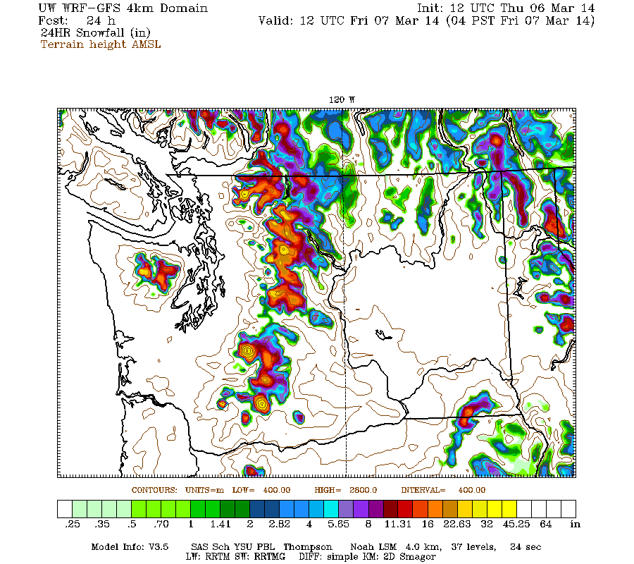
Another update a day later, following 2 more subsequent runs of the UW WRF-GFS model at 12-hour intervals and very heavy precip overnight into Thursday morning from southwestern BC to the northern Sierra Nevada, at snow levels ranging from 5000 ft in BC to 6000 ft in Washington to 8000 ft in Oregon and over 9000 ft in California. The precip changed from rain to snow at higher-elevation sites by midnight, oddly enough earliest in Oregon and southern Washington as an upper trough (cold air aloft) arrived in that region first, while remaining warmest at higher elevations on the west slopes of the North Cascades into Thursday morning. The trailing surface cold front will pass through around midday Thursday, cooling temperatures substantially at all elevations and lowering snow levels to 4000 ft throughout the region from BC to Oregon, with about 5000 ft in northern California.
After all the rain, at least it is finally going to snow very heavily at reasonable elevations! Snowfall over the 24 hour period through 4am Friday is still expected to be 2-3 ft over the west slopes and volcanic peaks of the Olympics and Washington Cascades, with 1-2 in the Oregon Cascades:

The NWS's GFS model and their Quantitative Precipitation Forecasts are showing up to 4-6" of additional precip over the next week for the mountains of southwestern BC, Washington, Oregon, and northern California, with about 1" extending south into the northernmost Sierra Nevada. Here is total precipitation in inches predicted over the next 7 days through Thursday March 12, almost all of which will occur during the first 5 days through Tuesday morning along the West Coast:
There is still expected to be a major lull in precipitation from Friday afternoon through Saturday morning for Oregon and Washington, as a transient weak ridge pushes the next incoming system northward towards the central BC coast and Vancouver Island. Eventually that system and its associated atmospheric river shift southward over Washington and Oregon during the day Saturday. That weekend system is still predicted to have even higher snow levels than the one on Wednesday (perhaps 7000-8000 ft), but not quite as much precip either. In any case, snowfall over the weekend will once again be limited to higher elevations only.
The predictions for this weekend's atmospheric river event (the second of this storm cycle) have remained very consistent over subsequent model runs, compare this image for Saturday morning with the same prediction made 4 days earlier (last image of initial post above), and it looks almost identical:
Or just view the D(model)/D(t) for that to avoid scrolling back up:
www.atmos.washington.edu/~ovens/wxloop.c...v+v2014030812///+-st
Snowfall during the next 3 days through 5am Sunday (PDT already!) is predicted to be 2-6 ft over southwestern BC and the Washington Cascades, around 1-3 ft over the Olympics, with 1-2 ft in the Oregon Cascades and Mount Shasta, and less than 1 ft extending south to Lassen Peak. The majority of that will fall through Friday midday, except at high elevations in southwestern BC and Washington only which will get additional heavy snowfall Saturday and Sunday:
Higher resolution version of that, showing the Pacific Northwest and also zoomed in on Washington and Oregon:
This loop shows how the model predictions for snowfall during the 3-day period through 4am Sunday have evolved between 10 subsequent runs over the last 5 days, the D(model)/D(t). Very consistent in the overall picture, with ongoing variation in amounts and southern extent:
www.atmos.washington.edu/~ovens/wxloop.c...2+v2014030912///+-st
By Sunday evening, some significant snowfall may be occurring in the northern Washington Cascades as temperatures cool. Another system (or a pair of them in rapid succession) will arrive from Sunday evening through Monday, with snowfall ending on Tuesday morning. Snow levels continue to look much more reasonable for these final systems, and with snowfall still likely to extend through Oregon too. Additional snowfall during the subsequent 2 days ending 5am next Tuesday is predicted to be 1-2 ft over southwestern BC and the Washington, with about 1 ft in the Oregon Cascades and perhaps some snowfall extending south to the northern Sierra:
The D(model)/D(t) for that 2-day period has changed significantly despite only 6 model runs so far extending out to that period. Precipitation has shifted southward on later model runs, greatly increasing predicted snowfall in Oregon while reducing it over southwestern BC:
www.atmos.washington.edu/~ovens/wxloop.c...8+v2014031112///+-st
Details of those final systems will likely continue to change as that period draws closer, as it is still 4-5 days out, especially given that the evolution of the very strong system on Saturday will have a significant effect on the development of the subsequent systems, and on upcoming model predictions.
Beyond Tuesday, it still appears likely that this storm cycle will come to an end over the Northwest, with a moderate ridge of high pressure building over the West Coast during the middle of next week. A new storm cycle (or perhaps it's still linked to this one? hard to say for sure looking at jet stream and upper-level forecasts) is expected to develop on Monday with heavy precip and snowfall primarily over south-central and southeast Alaska for several days, and these amounts have increased substantially in more recent model runs. Here is a broad overview from the 36km resolution showing snowfall over the 3-day period through 5pm next Thursday, with nothing over Washington/Oregon (at this low resolution) and 3-6 ft predicted over parts of Alaska:
[size=small](This is actually model snow precip and not snowfall, but that distinction is unimportant for this image.)[/size]
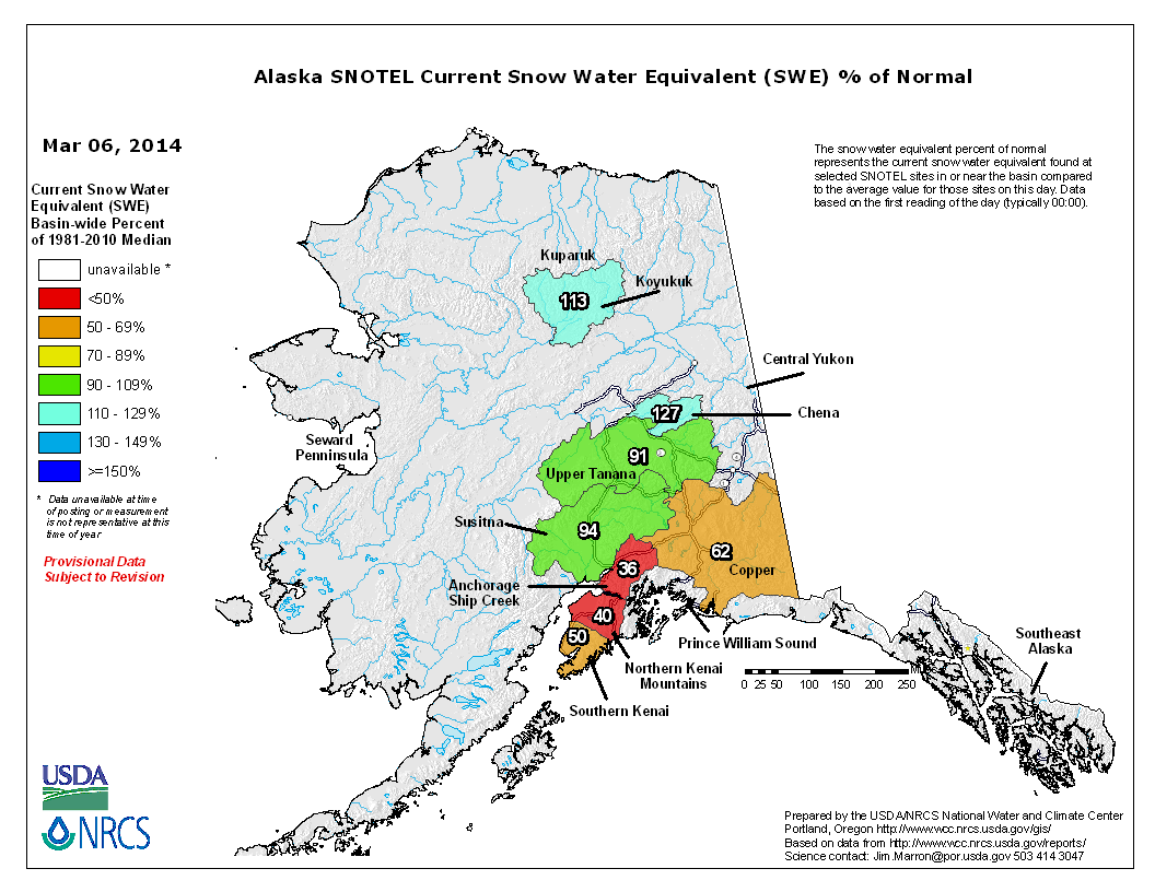
South-central Alaska is also suffering from well-below-normal snowpack this season at elevations of interest for most skiing there and where all SNOTEL sites are located (below 3000-5000 ft). For example, snow depth atop Alyeska at 2750 ft is about half of normal now with less than 70", and snowpack at SNOTEL sites in that region is less than half of normal too:
So a major storm cycle with several feet of snowfall would be very welcome there. However, due to the huge atmospheric river event in mid-late January (during the Northwest's glorious 12-day sunny high-pressure period), which brought torrential rains up to 8000-10000 ft and produced a truly historic avalanche cycle near Valdez, it is likely that snowpack at higher elevations on the numerous icefields is already much closer to normal.
with an additional 3-8 ft predicted through Tuesday for southwestern BC, Washington, and Oregon!
Another update a day later, following 2 more subsequent runs of the UW WRF-GFS model at 12-hour intervals and very heavy precip overnight into Thursday morning from southwestern BC to the northern Sierra Nevada, at snow levels ranging from 5000 ft in BC to 6000 ft in Washington to 8000 ft in Oregon and over 9000 ft in California. The precip changed from rain to snow at higher-elevation sites by midnight, oddly enough earliest in Oregon and southern Washington as an upper trough (cold air aloft) arrived in that region first, while remaining warmest at higher elevations on the west slopes of the North Cascades into Thursday morning. The trailing surface cold front will pass through around midday Thursday, cooling temperatures substantially at all elevations and lowering snow levels to 4000 ft throughout the region from BC to Oregon, with about 5000 ft in northern California.
After all the rain, at least it is finally going to snow very heavily at reasonable elevations! Snowfall over the 24 hour period through 4am Friday is still expected to be 2-3 ft over the west slopes and volcanic peaks of the Olympics and Washington Cascades, with 1-2 in the Oregon Cascades:
The NWS's GFS model and their Quantitative Precipitation Forecasts are showing up to 4-6" of additional precip over the next week for the mountains of southwestern BC, Washington, Oregon, and northern California, with about 1" extending south into the northernmost Sierra Nevada. Here is total precipitation in inches predicted over the next 7 days through Thursday March 12, almost all of which will occur during the first 5 days through Tuesday morning along the West Coast:
There is still expected to be a major lull in precipitation from Friday afternoon through Saturday morning for Oregon and Washington, as a transient weak ridge pushes the next incoming system northward towards the central BC coast and Vancouver Island. Eventually that system and its associated atmospheric river shift southward over Washington and Oregon during the day Saturday. That weekend system is still predicted to have even higher snow levels than the one on Wednesday (perhaps 7000-8000 ft), but not quite as much precip either. In any case, snowfall over the weekend will once again be limited to higher elevations only.
The predictions for this weekend's atmospheric river event (the second of this storm cycle) have remained very consistent over subsequent model runs, compare this image for Saturday morning with the same prediction made 4 days earlier (last image of initial post above), and it looks almost identical:
Or just view the D(model)/D(t) for that to avoid scrolling back up:
www.atmos.washington.edu/~ovens/wxloop.c...v+v2014030812///+-st
Snowfall during the next 3 days through 5am Sunday (PDT already!) is predicted to be 2-6 ft over southwestern BC and the Washington Cascades, around 1-3 ft over the Olympics, with 1-2 ft in the Oregon Cascades and Mount Shasta, and less than 1 ft extending south to Lassen Peak. The majority of that will fall through Friday midday, except at high elevations in southwestern BC and Washington only which will get additional heavy snowfall Saturday and Sunday:
Higher resolution version of that, showing the Pacific Northwest and also zoomed in on Washington and Oregon:
This loop shows how the model predictions for snowfall during the 3-day period through 4am Sunday have evolved between 10 subsequent runs over the last 5 days, the D(model)/D(t). Very consistent in the overall picture, with ongoing variation in amounts and southern extent:
www.atmos.washington.edu/~ovens/wxloop.c...2+v2014030912///+-st
By Sunday evening, some significant snowfall may be occurring in the northern Washington Cascades as temperatures cool. Another system (or a pair of them in rapid succession) will arrive from Sunday evening through Monday, with snowfall ending on Tuesday morning. Snow levels continue to look much more reasonable for these final systems, and with snowfall still likely to extend through Oregon too. Additional snowfall during the subsequent 2 days ending 5am next Tuesday is predicted to be 1-2 ft over southwestern BC and the Washington, with about 1 ft in the Oregon Cascades and perhaps some snowfall extending south to the northern Sierra:
The D(model)/D(t) for that 2-day period has changed significantly despite only 6 model runs so far extending out to that period. Precipitation has shifted southward on later model runs, greatly increasing predicted snowfall in Oregon while reducing it over southwestern BC:
www.atmos.washington.edu/~ovens/wxloop.c...8+v2014031112///+-st
Details of those final systems will likely continue to change as that period draws closer, as it is still 4-5 days out, especially given that the evolution of the very strong system on Saturday will have a significant effect on the development of the subsequent systems, and on upcoming model predictions.
Beyond Tuesday, it still appears likely that this storm cycle will come to an end over the Northwest, with a moderate ridge of high pressure building over the West Coast during the middle of next week. A new storm cycle (or perhaps it's still linked to this one? hard to say for sure looking at jet stream and upper-level forecasts) is expected to develop on Monday with heavy precip and snowfall primarily over south-central and southeast Alaska for several days, and these amounts have increased substantially in more recent model runs. Here is a broad overview from the 36km resolution showing snowfall over the 3-day period through 5pm next Thursday, with nothing over Washington/Oregon (at this low resolution) and 3-6 ft predicted over parts of Alaska:
[size=small](This is actually model snow precip and not snowfall, but that distinction is unimportant for this image.)[/size]
South-central Alaska is also suffering from well-below-normal snowpack this season at elevations of interest for most skiing there and where all SNOTEL sites are located (below 3000-5000 ft). For example, snow depth atop Alyeska at 2750 ft is about half of normal now with less than 70", and snowpack at SNOTEL sites in that region is less than half of normal too:
So a major storm cycle with several feet of snowfall would be very welcome there. However, due to the huge atmospheric river event in mid-late January (during the Northwest's glorious 12-day sunny high-pressure period), which brought torrential rains up to 8000-10000 ft and produced a truly historic avalanche cycle near Valdez, it is likely that snowpack at higher elevations on the numerous icefields is already much closer to normal.
Please Log in or Create an account to join the conversation.
- BillK
-
- User
-
Less
More
- Posts: 151
- Thank you received: 0
12 years 3 months ago #221079
by BillK
Replied by BillK on topic Re: New storm cycle with 4-8 ft snow Feb26-Mar8,2014!
Man, these threads are hell if you have dial-up!
Please Log in or Create an account to join the conversation.
- elliotts
-
- User
-
Less
More
- Posts: 6
- Thank you received: 0
12 years 3 months ago #221081
by elliotts
Replied by elliotts on topic Re: New storm cycle with 4-8 ft snow Feb26-Mar8,2014!
What is dial-up? ")
Please Log in or Create an account to join the conversation.
- DendriteSupertramp
-
- User
-
Less
More
- Posts: 25
- Thank you received: 0
12 years 3 months ago #221089
by DendriteSupertramp
Replied by DendriteSupertramp on topic Re: New storm cycle with 4-8 ft snow Feb26-Mar8,2014!
Who cares about AK and California too!...
Let's talk about another Storm Cycle starting next weekend.(pattern shift?)
Also, why does the CPC seem to indicate mild conditions in the 8-14?
Again, the PNA and MJO are primed.
Let's talk about another Storm Cycle starting next weekend.(pattern shift?)
Also, why does the CPC seem to indicate mild conditions in the 8-14?
Again, the PNA and MJO are primed.
Please Log in or Create an account to join the conversation.