- Posts: 635
- Thank you received: 0
New storm cycle with 4-8 ft snow Feb26-Mar10,2014!
- Amar Andalkar
-
 Topic Author
- User
-

Less
More
12 years 3 months ago - 12 years 3 months ago #221115
by Amar Andalkar
Replied by Amar Andalkar on topic Re: New storm cycle with 4-8 ft snow Feb26-Mar8,2014!
Sunrise, sunset, and sunrise again between the storms:
[size=small]Enjoyed an awesome mostly-sunny day at Crystal Mountain Friday during a major lull between warm wet storm systems, yo-yoing 73,500 vert in 45 laps off Rainier Express and the gondola (and Forest Queen at day's end after the upper lifts had closed), my biggest ski day since 2010. About 4-8" of very dense "powder" atop a very uneven chunky surface left by previous days' skiers. Unfortunately I'd brought my alpine skis which were far too narrow (Volkl 7 24 Pro, 115-77-104) to enjoy those type of hidden minefield conditions, with potentially knee-twisting chunks lying just barely-buried and hidden everywhere, and any of my wider skis (88, 89, 106, or 125 mm underfoot) would have been a better choice for the morning. Made the best of it though to maximize my own enjoyment on the day, cautiously skied a few quick laps of the untracked powder to start the day before the increasing sunshine started cooking it, and then switched to lapping groomers at high speed after 9:30am. Shockingly there were no crowds or lines at all anytime (on a sunny powder day?!? although I once again avoided High Campbell), not even a morning rush this time and the gondola started loading at 8:45am. It was great to have a Friday that actually felt like a nice uncrowded midweek day the way it always used to be, not the overcrowded semi-Saturday that it often is the past few years given the increase in job-flexibility for so many people. Maybe most people think the ski season is over already (or never started)? It was not nearly as amazing conditions as my previous day at Crystal ( deep powder on February 19 during the previous huge storm cycle ), but made up for with glorious sunshine and minimal winds, easily the best day so far at Crystal during the current storm cycle. Anyway, first some photos and then on to the update later:[/size]
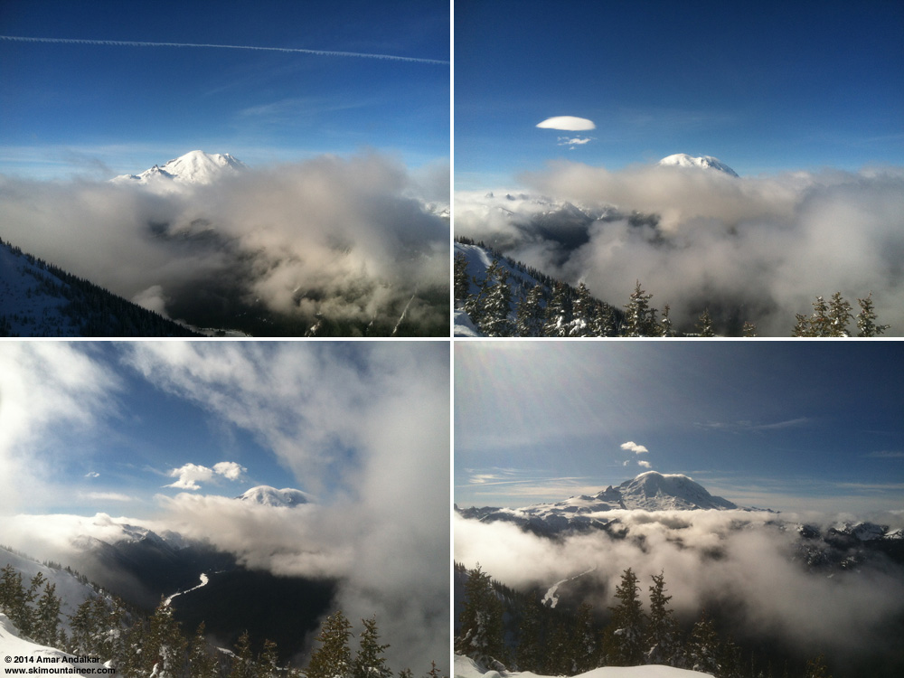
[size=small]Four views of Mount Rainier from atop Crystal Mountain, March 7 (iPhone photos, forgot real camera in the car):
The Mountain is already out at 9am. Incipient lenticular atop Rainier and full-fledged lee-wave cloud hovering off to its east, 11am.
Fleeting view through a swirl of clouds, 1pm. Clearest view of the day at 2:30pm, still tightly capped by a lenticular.[/size]
The strong and very wet system which moved into the Pacific Northwest on Wednesday evening and continued throughout Thursday finally moved out on Friday morning, leaving behind several inches of rain and eventually 3-15" of snow in the Washington and Oregon Cascades, significantly less than the forecasts and models had predicted. Almost the entire US West Coast cleared out during the major lull from Friday morning into Saturday morning between the two major atmospheric river events of this storm cycle, but southwestern BC never quite did. As usual, clearing was most complete farther south towards California.
While it was sunny to the south along the US West Coast, heavy precip and snowfall from the incoming storm and atmospheric river already started during the day Friday along the coast of BC and southeast Alaska. Mount Washington on Vancouver Island reported 3" new snow as of Saturday, and Whistler 2", but the real jackpot was much farther north with 14" new at Shames Mountain near Terrace, BC, and even 4" at Hudson Bay Mountain near Smithers, 70 miles farther inland from the coast. Lighter precip and snowfall extended into southeast Alaska with 2" new at Eaglecrest near Juneau.
Here is a selection of interesting webcam views showing weather conditions during the lull:
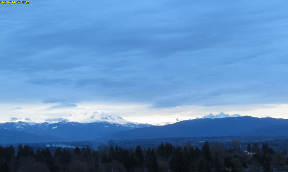
[size=small]Skies almost clearing by sunset Friday on Mount Baker and Twin Sisters Mountain, as seen on the visibility camera from Ferndale .[/size]
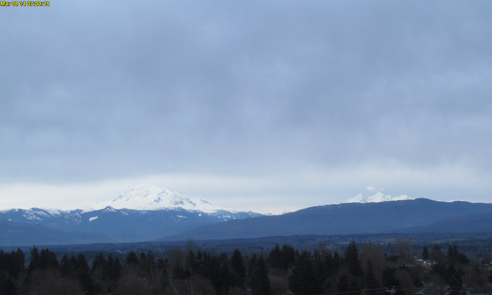
[size=small]Brief view of Mount Baker and Twin Sisters Mountain at sunrise Saturday before the next system arrived, as seen on the visibility camera from Ferndale .[/size]
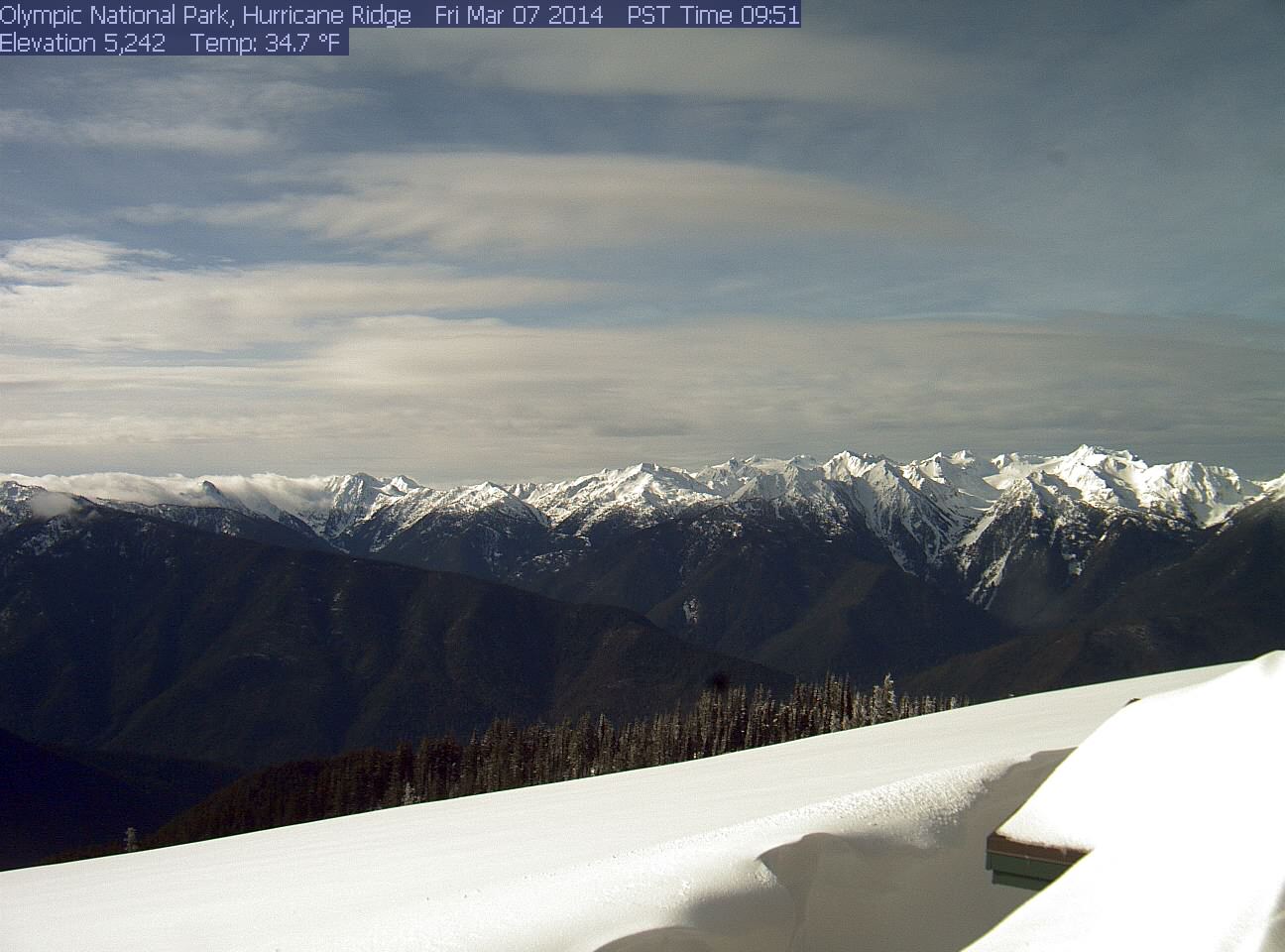
[size=small]Morning sun on the Olympics Friday from Hurricane Ridge .[/size]
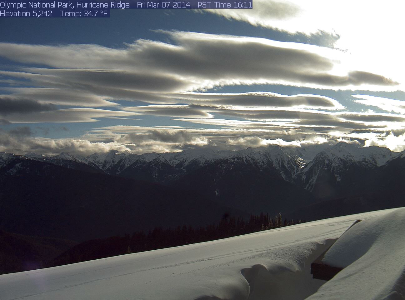
[size=small]Harbingers of the alien invasion (or maybe just the next incoming system): an entire fleet of alien spacecraft (or perhaps lenticulars) cruises the skies above the Olympics on Friday afternoon.[/size]
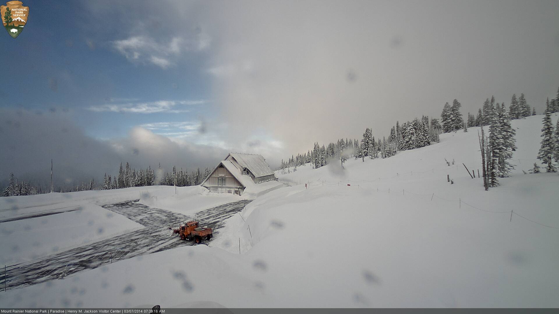
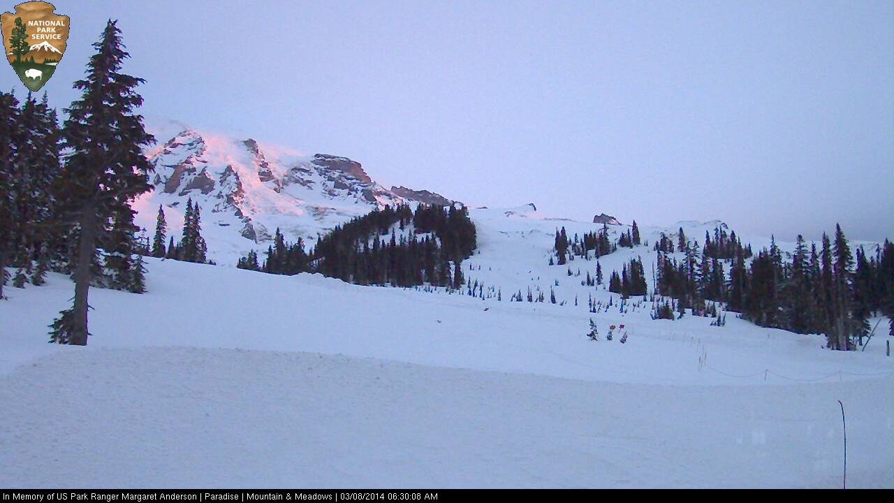
[size=small]Plowing deep snow at dawn on Friday in the parking lot at Paradise .[/size]
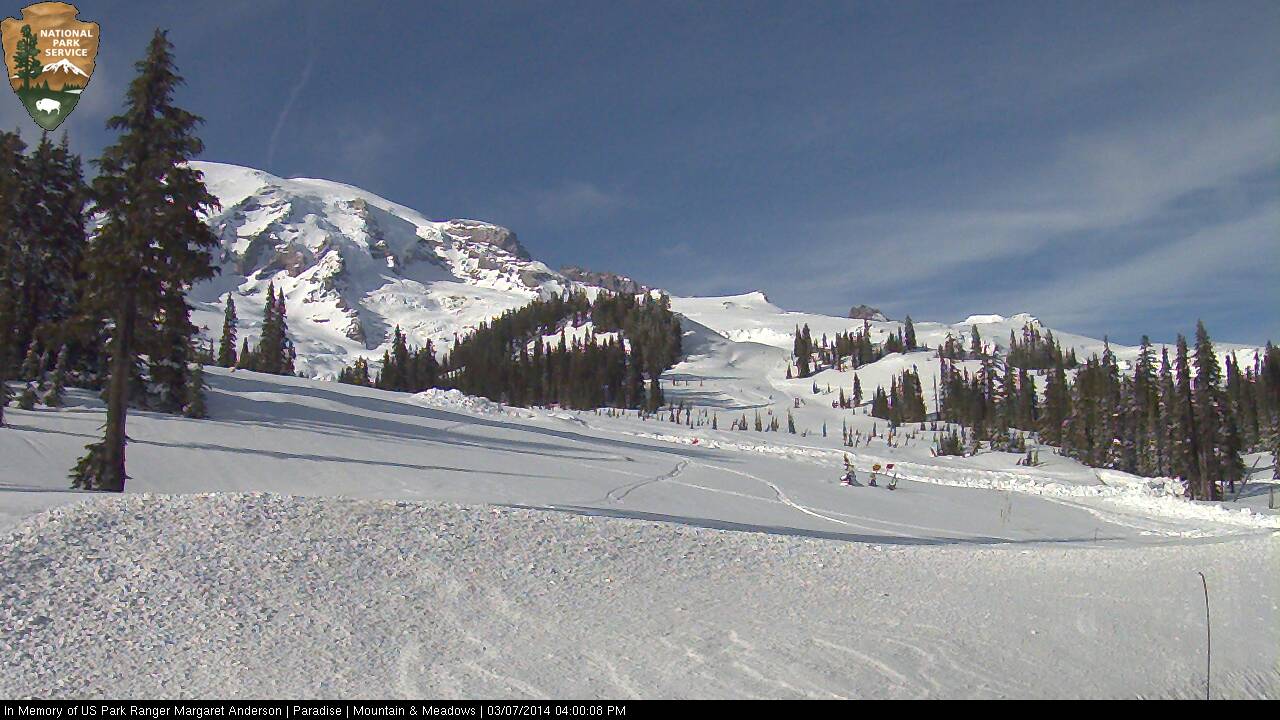
[size=small]Clouds obscured this side of the Mountain for most of Friday, but by late afternoon it was finally fully visible from Paradise .[/size]
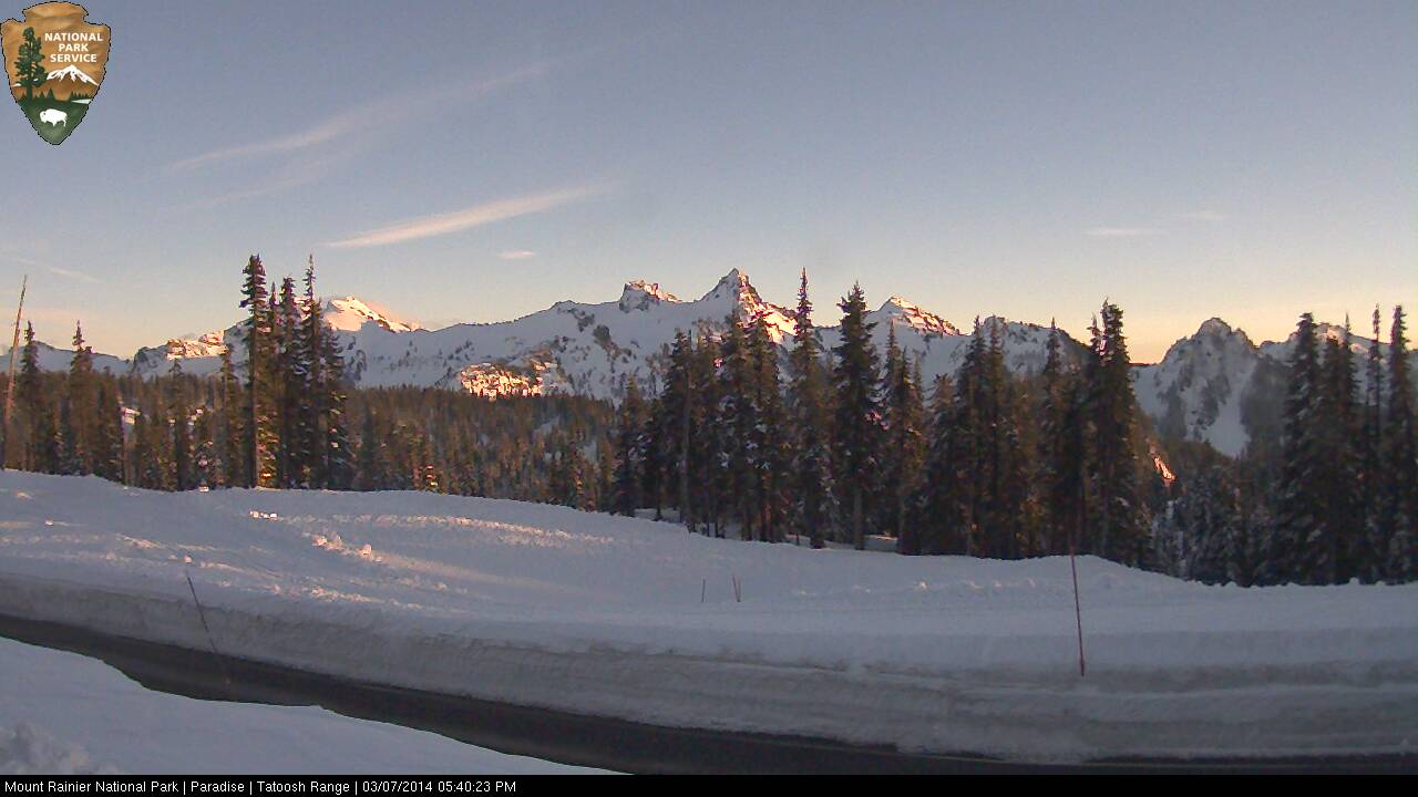
[size=small]Sunset on the Tatoosh Range Friday seen from Paradise .[/size]
[size=small]Brief glow of dawn on the Mountain Saturday, but quickly obscured by the incoming storm.[/size]
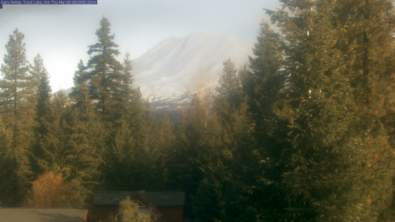
[size=small]Mount Adams looking ready to ski on Friday morning, as seen from Trout Lake .[/size]
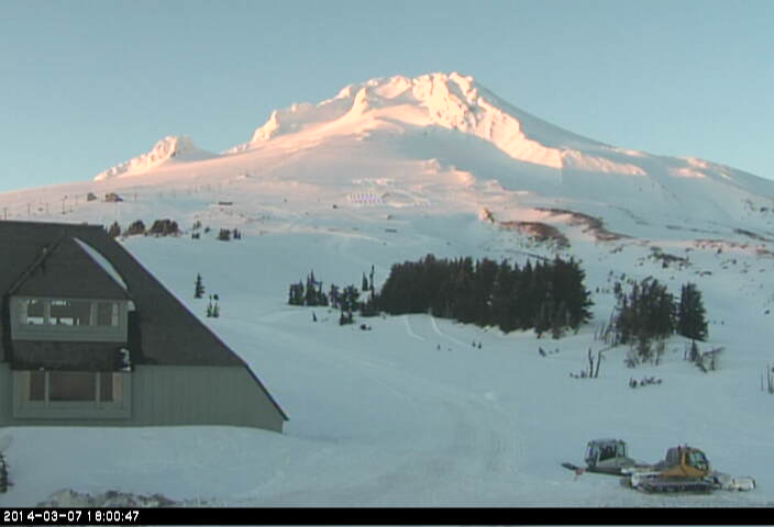
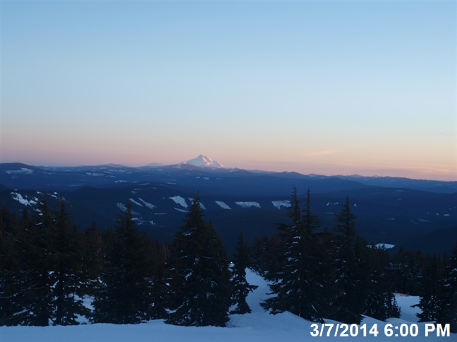
[size=small]Last light on Mount Hood Friday, as seen from Timberline .[/size]
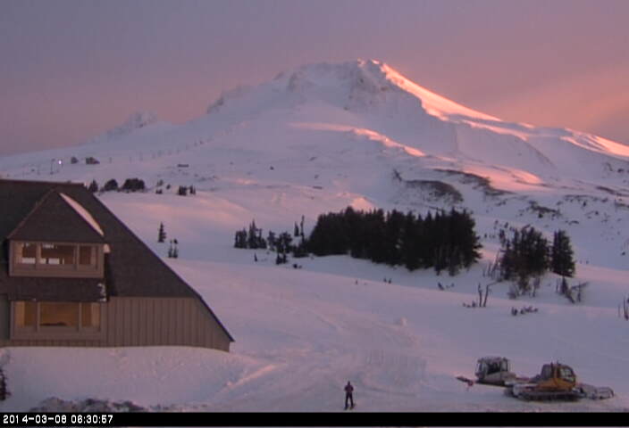
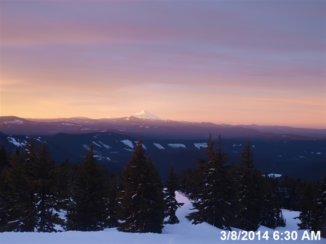
[size=small]First light on Mount Hood Saturday, as seen from Timberline .[/size]
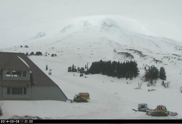
[size=small]But the storm arrives shortly on Mount Hood Saturday morning, as seen from Timberline .[/size]
[size=small]Sunset glow on Mount Jefferson Friday, looking south from Timberline Lodge on Mount Hood .[/size]
[size=small]Sunrise glow on Mount Jefferson Saturday, looking south from Timberline Lodge on Mount Hood .[/size]
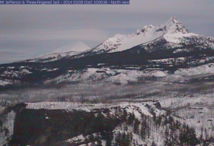
[size=small]Lenticular growing above Mount Jefferson on Saturday morning behind Three Fingered Jack at right, looking NE from Hoodoo Butte .[/size]
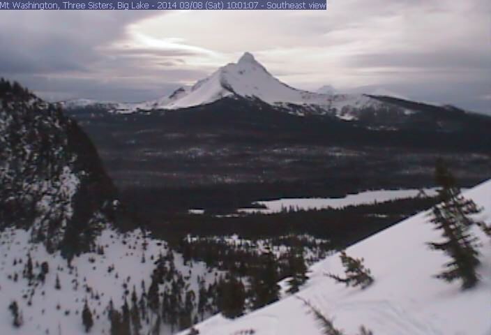
[size=small]A hole in the cloud deck above Mount Washington on Saturday morning, looking SE from Hoodoo Butte .[/size]
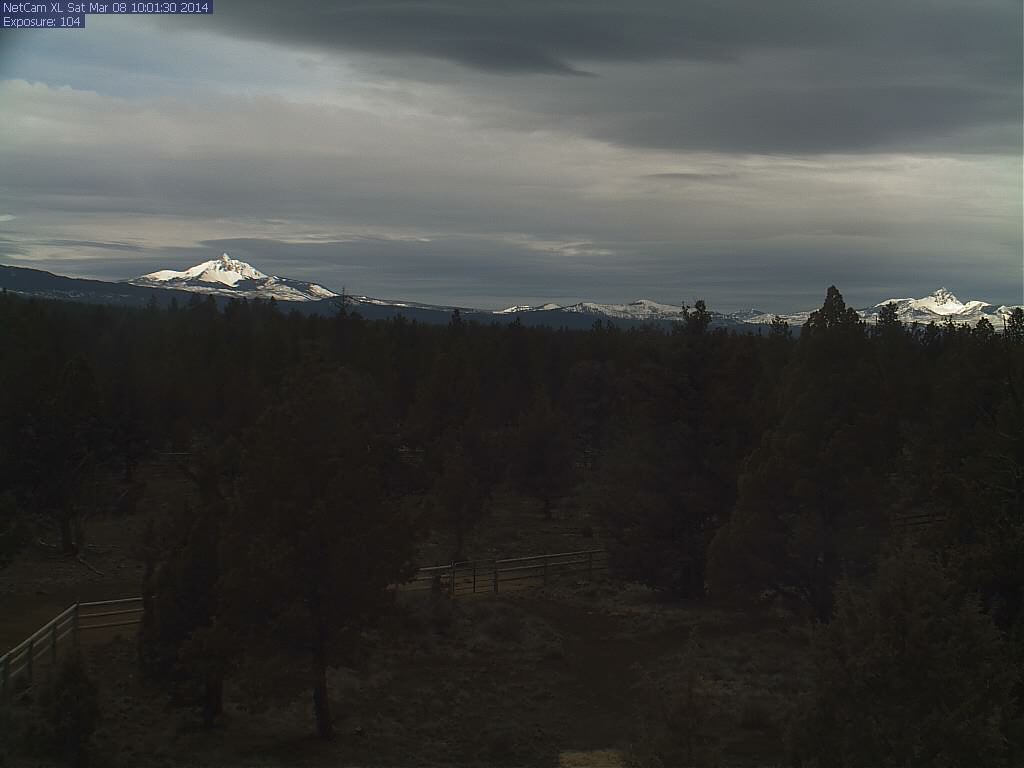
[size=small]Sunlight shining from above on Mount Washington (left) and Three Fingered Jack (right) on Saturday morning, at the same time as the previous 2 images but from the opposite side at Lucas ranch between Bend and Sisters.[/size]
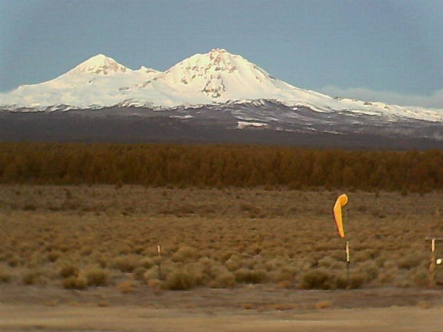
[size=small]Sunrise on North Sister and Middle Sister Friday, as seen on the Cascade Flyers webcam between Bend and Sisters (2014-03-07 6:20am).[/size]
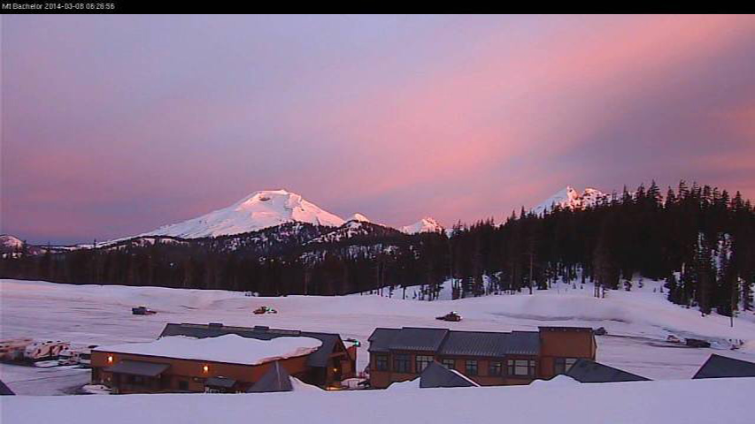
[size=small]Sunrise glow on South Sister, Middle Sister, North Sister, and Broken Top (left to right) Saturday as seen from Mount Bachelor .[/size]
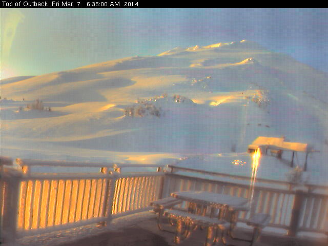
[size=small]Sunrise glow on Mount Bachelor Friday as seen from Pine Marten Lodge at 7700 ft.[/size]
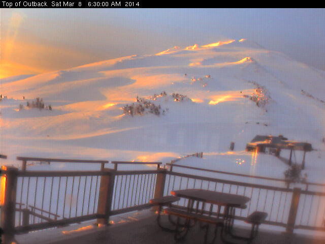
[size=small]Sunrise glow on Mount Bachelor Saturday as seen from Pine Marten Lodge at 7700 ft, same glow but less rime.[/size]
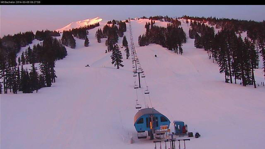
[size=small]Sunrise glow on Mount Bachelor Saturday as seen from West Village at 6300 ft.[/size]
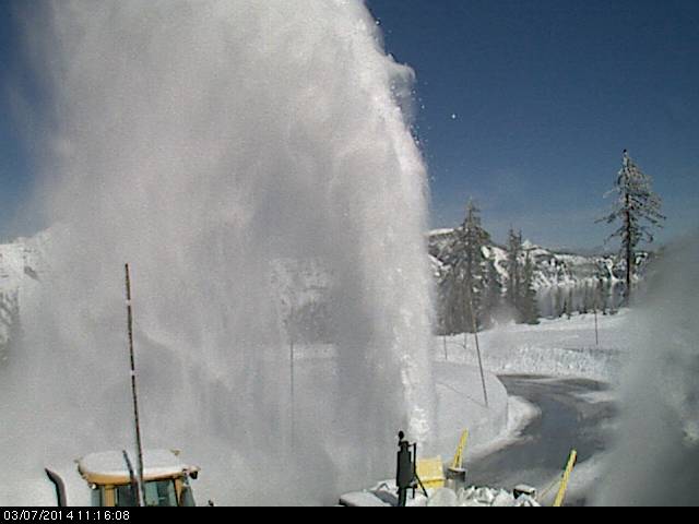
[size=small]Snow blower dealing with deep snow on Friday at Crater Lake .[/size]
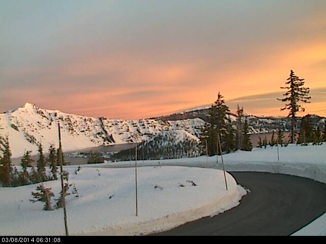
[size=small]Sunrise glow on Saturday at Crater Lake .[/size]
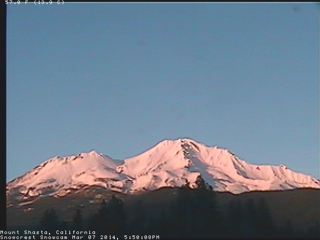
[size=small]Mount Shasta at sunset Friday, as seen on the SnowCrest webcam .[/size]
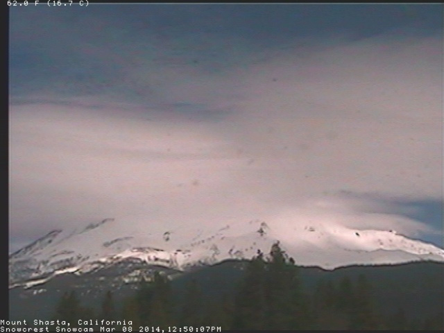
[size=small]Mount Shasta capped by an awesome jumble of lenticular clouds midday Saturday as the next storm approaches, as seen on the SnowCrest webcam .[/size]
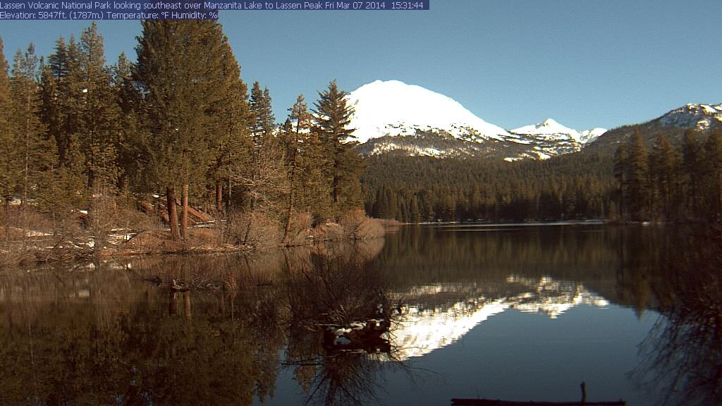
[size=small]Lassen Peak glowing far too brightly but reflected nicely in the Manzanita Lake webcam on Friday afternoon.[/size]
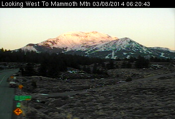
[size=small]Sunrise glow on Mammoth Mountain Saturday, as seen on the Caltrans webcam .[/size]
Update #4 to be posted shortly...
[size=small]Enjoyed an awesome mostly-sunny day at Crystal Mountain Friday during a major lull between warm wet storm systems, yo-yoing 73,500 vert in 45 laps off Rainier Express and the gondola (and Forest Queen at day's end after the upper lifts had closed), my biggest ski day since 2010. About 4-8" of very dense "powder" atop a very uneven chunky surface left by previous days' skiers. Unfortunately I'd brought my alpine skis which were far too narrow (Volkl 7 24 Pro, 115-77-104) to enjoy those type of hidden minefield conditions, with potentially knee-twisting chunks lying just barely-buried and hidden everywhere, and any of my wider skis (88, 89, 106, or 125 mm underfoot) would have been a better choice for the morning. Made the best of it though to maximize my own enjoyment on the day, cautiously skied a few quick laps of the untracked powder to start the day before the increasing sunshine started cooking it, and then switched to lapping groomers at high speed after 9:30am. Shockingly there were no crowds or lines at all anytime (on a sunny powder day?!? although I once again avoided High Campbell), not even a morning rush this time and the gondola started loading at 8:45am. It was great to have a Friday that actually felt like a nice uncrowded midweek day the way it always used to be, not the overcrowded semi-Saturday that it often is the past few years given the increase in job-flexibility for so many people. Maybe most people think the ski season is over already (or never started)? It was not nearly as amazing conditions as my previous day at Crystal ( deep powder on February 19 during the previous huge storm cycle ), but made up for with glorious sunshine and minimal winds, easily the best day so far at Crystal during the current storm cycle. Anyway, first some photos and then on to the update later:[/size]
[size=small]Four views of Mount Rainier from atop Crystal Mountain, March 7 (iPhone photos, forgot real camera in the car):
The Mountain is already out at 9am. Incipient lenticular atop Rainier and full-fledged lee-wave cloud hovering off to its east, 11am.
Fleeting view through a swirl of clouds, 1pm. Clearest view of the day at 2:30pm, still tightly capped by a lenticular.[/size]
The strong and very wet system which moved into the Pacific Northwest on Wednesday evening and continued throughout Thursday finally moved out on Friday morning, leaving behind several inches of rain and eventually 3-15" of snow in the Washington and Oregon Cascades, significantly less than the forecasts and models had predicted. Almost the entire US West Coast cleared out during the major lull from Friday morning into Saturday morning between the two major atmospheric river events of this storm cycle, but southwestern BC never quite did. As usual, clearing was most complete farther south towards California.
While it was sunny to the south along the US West Coast, heavy precip and snowfall from the incoming storm and atmospheric river already started during the day Friday along the coast of BC and southeast Alaska. Mount Washington on Vancouver Island reported 3" new snow as of Saturday, and Whistler 2", but the real jackpot was much farther north with 14" new at Shames Mountain near Terrace, BC, and even 4" at Hudson Bay Mountain near Smithers, 70 miles farther inland from the coast. Lighter precip and snowfall extended into southeast Alaska with 2" new at Eaglecrest near Juneau.
Here is a selection of interesting webcam views showing weather conditions during the lull:
[size=small]Skies almost clearing by sunset Friday on Mount Baker and Twin Sisters Mountain, as seen on the visibility camera from Ferndale .[/size]
[size=small]Brief view of Mount Baker and Twin Sisters Mountain at sunrise Saturday before the next system arrived, as seen on the visibility camera from Ferndale .[/size]
[size=small]Morning sun on the Olympics Friday from Hurricane Ridge .[/size]
[size=small]Harbingers of the alien invasion (or maybe just the next incoming system): an entire fleet of alien spacecraft (or perhaps lenticulars) cruises the skies above the Olympics on Friday afternoon.[/size]
[size=small]Plowing deep snow at dawn on Friday in the parking lot at Paradise .[/size]
[size=small]Clouds obscured this side of the Mountain for most of Friday, but by late afternoon it was finally fully visible from Paradise .[/size]
[size=small]Sunset on the Tatoosh Range Friday seen from Paradise .[/size]
[size=small]Brief glow of dawn on the Mountain Saturday, but quickly obscured by the incoming storm.[/size]
[size=small]Mount Adams looking ready to ski on Friday morning, as seen from Trout Lake .[/size]
[size=small]Last light on Mount Hood Friday, as seen from Timberline .[/size]
[size=small]First light on Mount Hood Saturday, as seen from Timberline .[/size]
[size=small]But the storm arrives shortly on Mount Hood Saturday morning, as seen from Timberline .[/size]
[size=small]Sunset glow on Mount Jefferson Friday, looking south from Timberline Lodge on Mount Hood .[/size]
[size=small]Sunrise glow on Mount Jefferson Saturday, looking south from Timberline Lodge on Mount Hood .[/size]
[size=small]Lenticular growing above Mount Jefferson on Saturday morning behind Three Fingered Jack at right, looking NE from Hoodoo Butte .[/size]
[size=small]A hole in the cloud deck above Mount Washington on Saturday morning, looking SE from Hoodoo Butte .[/size]
[size=small]Sunlight shining from above on Mount Washington (left) and Three Fingered Jack (right) on Saturday morning, at the same time as the previous 2 images but from the opposite side at Lucas ranch between Bend and Sisters.[/size]
[size=small]Sunrise on North Sister and Middle Sister Friday, as seen on the Cascade Flyers webcam between Bend and Sisters (2014-03-07 6:20am).[/size]
[size=small]Sunrise glow on South Sister, Middle Sister, North Sister, and Broken Top (left to right) Saturday as seen from Mount Bachelor .[/size]
[size=small]Sunrise glow on Mount Bachelor Friday as seen from Pine Marten Lodge at 7700 ft.[/size]
[size=small]Sunrise glow on Mount Bachelor Saturday as seen from Pine Marten Lodge at 7700 ft, same glow but less rime.[/size]
[size=small]Sunrise glow on Mount Bachelor Saturday as seen from West Village at 6300 ft.[/size]
[size=small]Snow blower dealing with deep snow on Friday at Crater Lake .[/size]
[size=small]Sunrise glow on Saturday at Crater Lake .[/size]
[size=small]Mount Shasta at sunset Friday, as seen on the SnowCrest webcam .[/size]
[size=small]Mount Shasta capped by an awesome jumble of lenticular clouds midday Saturday as the next storm approaches, as seen on the SnowCrest webcam .[/size]
[size=small]Lassen Peak glowing far too brightly but reflected nicely in the Manzanita Lake webcam on Friday afternoon.[/size]
[size=small]Sunrise glow on Mammoth Mountain Saturday, as seen on the Caltrans webcam .[/size]
Update #4 to be posted shortly...
Please Log in or Create an account to join the conversation.
- Amar Andalkar
-
Topic Author
- User
-
Less
More
- Posts: 635
- Thank you received: 0
12 years 3 months ago - 12 years 3 months ago #221136
by Amar Andalkar
Replied by Amar Andalkar on topic Re: New storm cycle with 4-8 ft snow Feb26-Mar10,2014!
Update #4: 168 hours (1 week) after initial post, 2-8 ft of snow has already fallen from southwestern BC to California,
with an additional 0.5-2 ft predicted through late Monday for southern Washington, Oregon, and northern California!
[size=small]Never did finish the partially-written update (referred to above) enough to post it by Saturday evening as planned, so I skipped it and just rolled it all into today's update:[/size]
The final days of this storm cycle have arrived, following the second of two atmospheric river events which brought heavy precipitation and high-elevation snowfall from southeastern Alaska to northern California starting on Friday and lasting through Sunday. Snow levels during the heaviest precip from Saturday midday into Sunday morning ranged from about 4000 ft in parts of southwestern BC and Vancouver Island (if far enough northwest), to 5000-6000 ft in the Olympics, BC Cascades, and North Cascades, 7000-8000 ft in the southern Washington and northern Oregon Cascades, and 9000 ft for most of the Oregon Cascades and northern California. The last system from tonight through Monday evening will bring additional significant precip and snowfall at much lower snow levels, but primarily for Oregon and northern California with only a limited amount extending into southern Washington, followed by several days of high pressure and sunshine from Tuesday through Thursday.
Despite pouring rain at most locations, very heavy snowfall was recorded during the second atmospheric river at sites far enough northwest and high enough up, with 24-hour totals through midday Sunday of 1-2 ft at some measurement sites. The largest amounts include 12" new at Shames Mountain near Terrace, BC, 23" at Mount Washington on Vancouver Island (4500 ft), over 20" at the Squamish River BCRFC site west of Whistler (which stayed all snow despite its modest 4500 ft elevation), 15" at Whistler Mountain (5400 ft), about 15" at the Chilliwack River BCRFC site (5300 ft in the BC Cascades just north of the US border near Mount Baker), over 18" at Brown Top SNOTEL (5800 ft near Mount Redoubt in the North Cascades), and about 16" at Harts Pass SNOTEL (6500 ft). Very little snowfall was recorded at any measurement sites south of the North Cascades, as all sites farther south were below the snow level.
Precip amounts through midday Sunday were generally in the 2-4" range at most mountain sites from southwestern BC to southern Oregon, with a sharp drop-off to about 1" or less in northern California. However, heavy precip continues on Sunday evening in northern California and southern Oregon, as the atmospheric river has moved steadily southward over the past 2 days, and although now much weaker is aimed directly at that region as of 5pm Sunday:
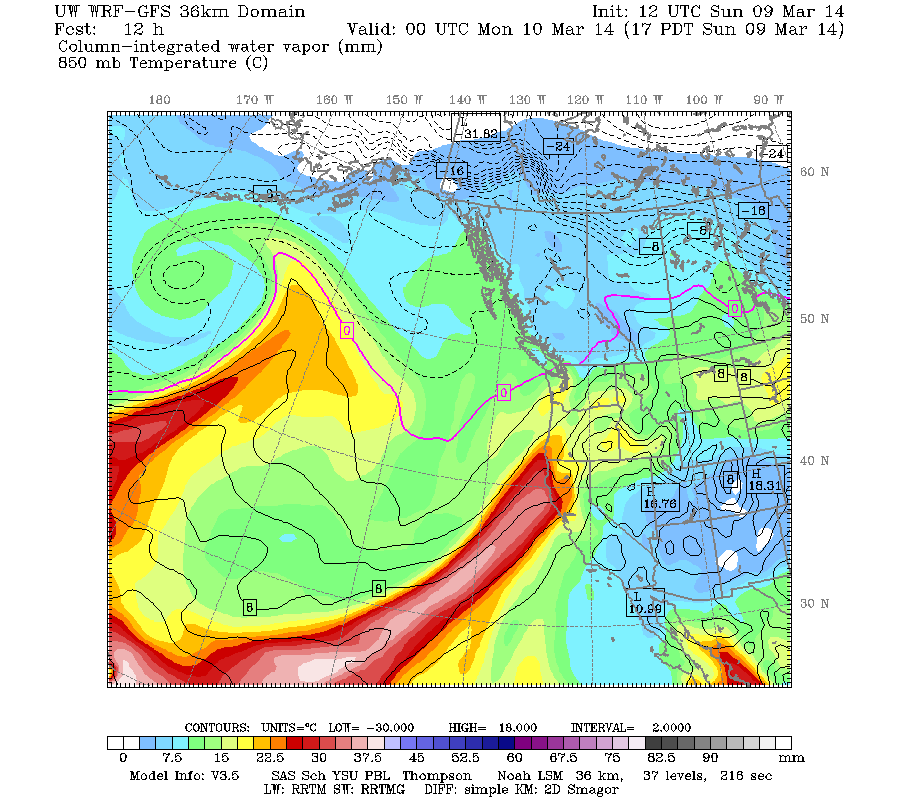
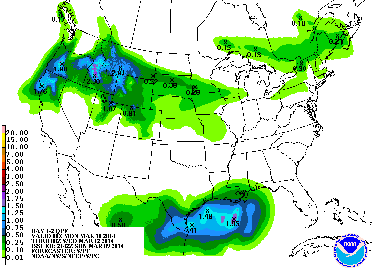
The NWS's GFS model and their Quantitative Precipitation Forecasts are showing up to 1-2" of additional precip during this storm cycle for the mountains of Oregon and northern California, with much less extending north into Washington. Here is the total precipitation in inches predicted over the next 2 days through Tuesday:
As the atmospheric river fades away, there will be a brief change to northwesterly flow which will only last through Monday night (and eventually northerly on Tuesday), as seen in the jet stream forecasts . Here is the current strong southwesterly jet as of 5pm Sunday, and the complete change predicted 24 hours later by 5pm Monday:
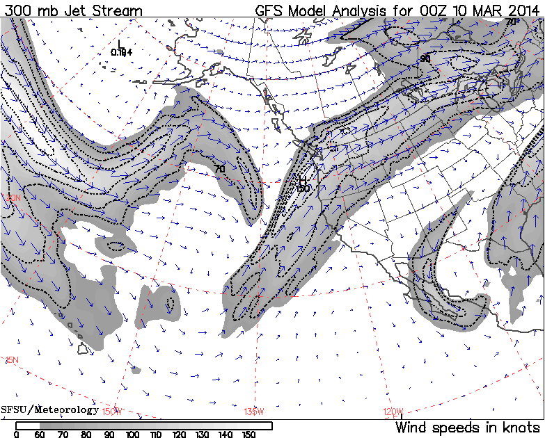
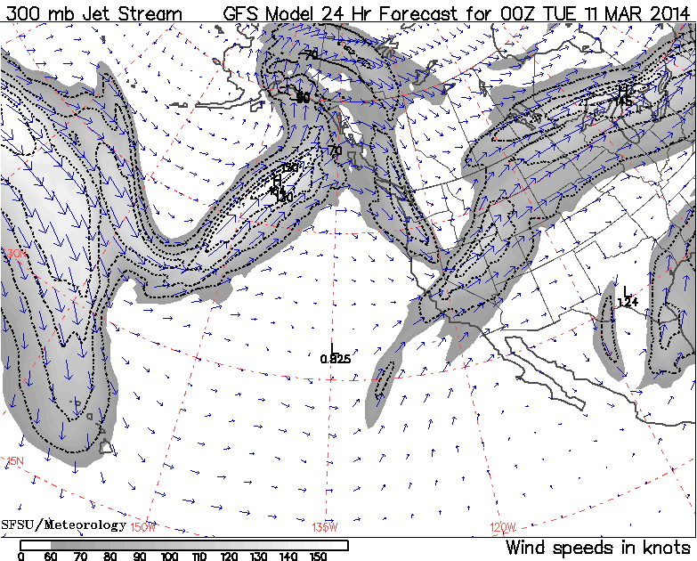
Also visible in the second image is another strong new jet stream that will be aimed directly into south-central and southeast Alaska by Monday, lasting through midweek (more on that below).
The incoming northwesterly flow is expected to lower snow levels greatly by Monday, and produce heavy snowfall where it interacts with remnants of the southwesterly moisture plume. Snowfall during the 2-day period through 5am Tuesday is predicted to be 1-2 ft in the Oregon Cascades, with less than 1 ft in the southern Washington Cascades and California Cascades, and a few inches extending into the northern Sierra Nevada:
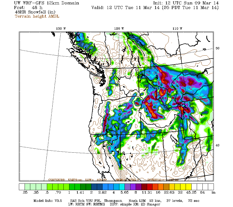
Higher resolution version of that, showing the Pacific Northwest and also zoomed in on Washington and Oregon:
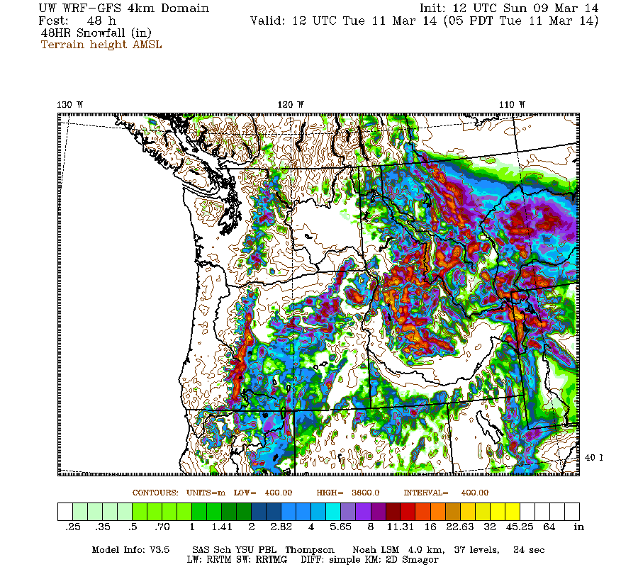
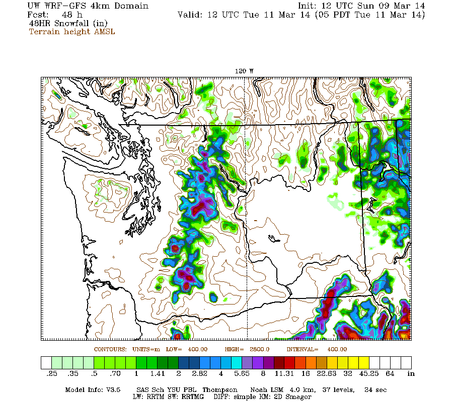
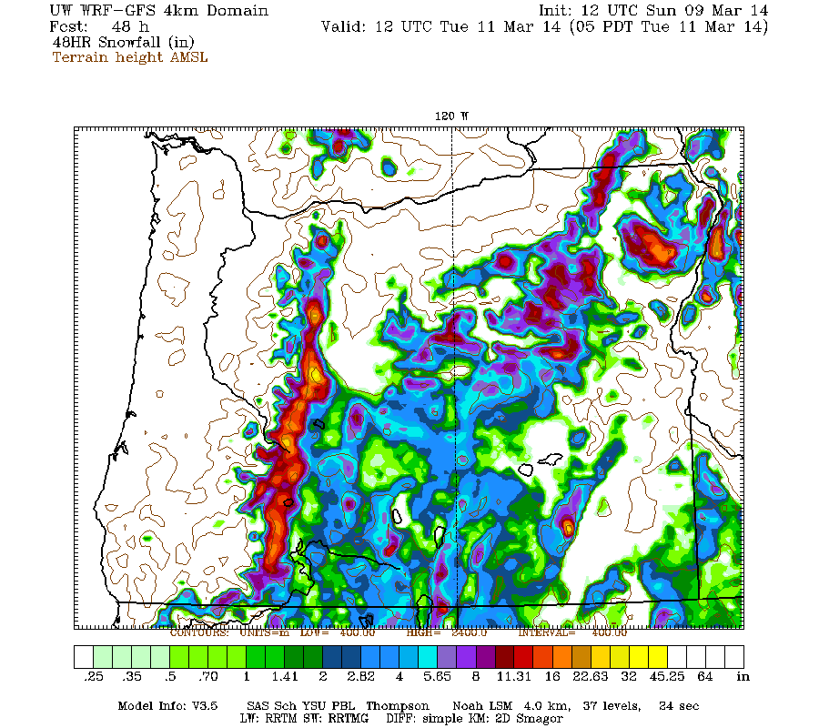
Maximum snowfall amounts of about 2 ft are shown over several of the volcanic peaks of the Oregon Cascades, with perhaps 2-3 ft in the Three Sisters region.
This loop shows how the model predictions for snowfall during the 2-day period through 5am Tuesday have evolved between 12 subsequent runs over the last 6 days, the D(model)/D(t). Lots of major changes early on, but eventually settling into a somewhat more consistent picture over the past 2-3 days, but with ongoing variation in amounts and geographic extent:
www.atmos.washington.edu/~ovens/wxloop.c...8+v2014031112///+-st
Based on that large degree of run-to-run variation, the snowfall amounts from the remaining system remain quite uncertain.
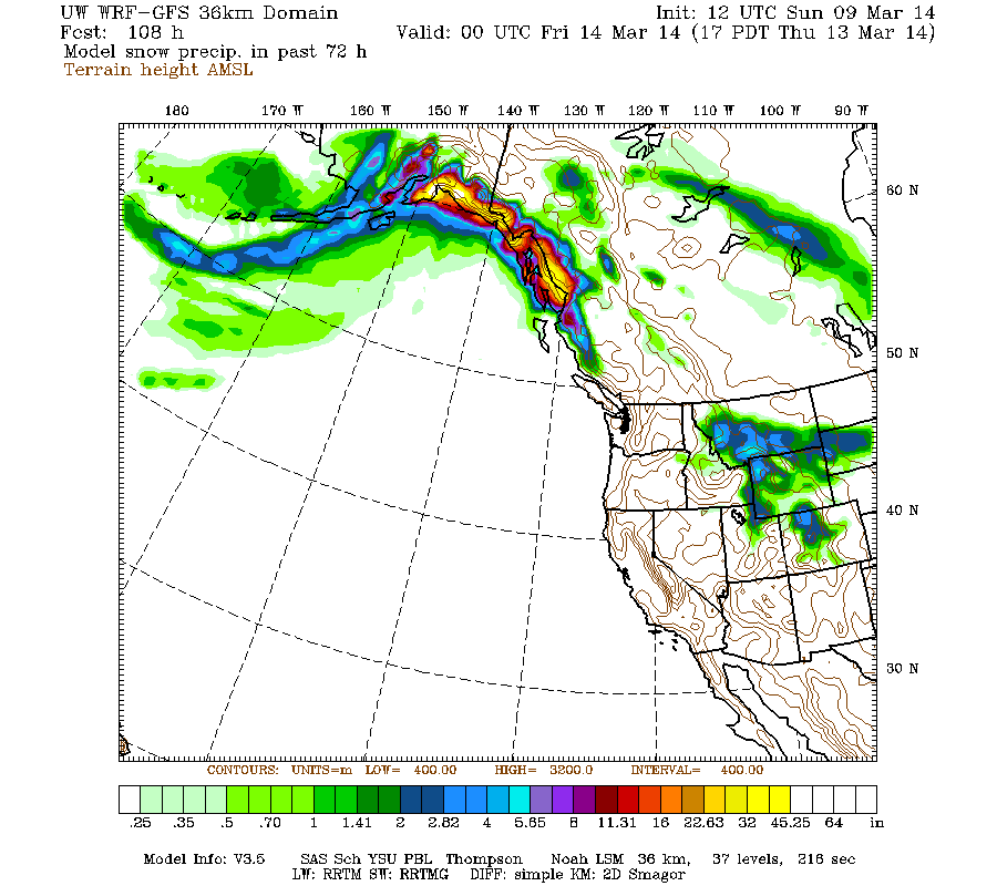
What does not appear to be uncertain is that high pressure will build on Tuesday, bringing clear skies throughout the US West Coast, although with lingering clouds in southwestern BC. Meanwhile, a very strong low pressure system has already developed Sunday south of the Aleutians and will moved eastward into the Gulf of Alaska on Monday. A series of additional storm systems will develop in the wake of that one, bringing very heavy precip and snowfall to south-central and southeast Alaska for several days through the end of the week. Here is a broad overview from the 36km resolution showing snowfall over the 3-day period through 5pm next Thursday, with 3-6 ft still predicted over most of the coastal mountains of south-central and southeast Alaska (compare with the same image in Update #3 above, looks very similar):
Or just view the D(model)/D(t) for that to avoid scrolling back up, very consistent throughout 7 model runs over the past 4 days:
www.atmos.washington.edu/~ovens/wxloop.c...2+v2014031400///+-st
Here is predicted snowfall over the subsequent 3-day period through 5pm next Sunday, with another 2-3 ft for Alaska and now also for most of the BC coast, with just a bit extending south into Washington:
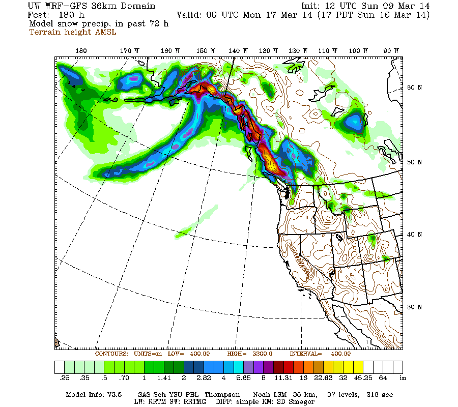
[size=small](The previous 2 images are actually model snow precip and not snowfall, but that distinction is unimportant here.)[/size]
The higher-resolution 12km version of that shows up to 1 ft of snowfall in the Washington Cascades, with one system predicted for Friday and another stronger system for next Sunday:
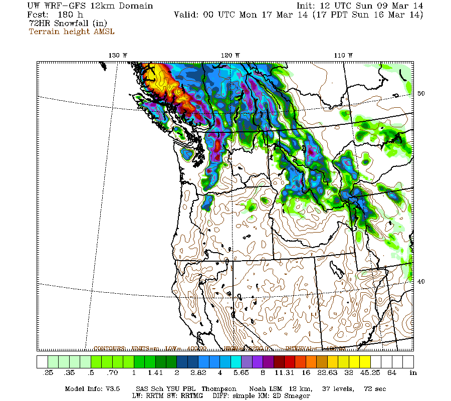
But that's still 5-7 days out, near the limit of accurate numerical weather prediction, so those storms are no sure thing quite yet. And all of that is still arriving on primarily southwest flow, wrapping around the strong lows in the Gulf of Alaska, but with northwesterly flow temporarily over the region on Friday as the flow moves around the northern end of high pressure over the northeast Pacific (see the jet stream forecasts again). Perhaps not the perfect powder pattern that some people are pining for, but perhaps enough.
The extended GFS model out to 384 hours (16 days) shows no evidence of a lengthy change to northwest flow anymore, although it produces additional storm systems during the 8-16 day period. This is the predicted 24-hour precip and sea level pressure isobars, click "Loop All" to see all the graphics (3 hour intervals up to 192 hours, 12 hour intervals beyond that):
GFS, North Pacific, 03/09/2014 18UTC, precip_p24
with an additional 0.5-2 ft predicted through late Monday for southern Washington, Oregon, and northern California!
[size=small]Never did finish the partially-written update (referred to above) enough to post it by Saturday evening as planned, so I skipped it and just rolled it all into today's update:[/size]
The final days of this storm cycle have arrived, following the second of two atmospheric river events which brought heavy precipitation and high-elevation snowfall from southeastern Alaska to northern California starting on Friday and lasting through Sunday. Snow levels during the heaviest precip from Saturday midday into Sunday morning ranged from about 4000 ft in parts of southwestern BC and Vancouver Island (if far enough northwest), to 5000-6000 ft in the Olympics, BC Cascades, and North Cascades, 7000-8000 ft in the southern Washington and northern Oregon Cascades, and 9000 ft for most of the Oregon Cascades and northern California. The last system from tonight through Monday evening will bring additional significant precip and snowfall at much lower snow levels, but primarily for Oregon and northern California with only a limited amount extending into southern Washington, followed by several days of high pressure and sunshine from Tuesday through Thursday.
Despite pouring rain at most locations, very heavy snowfall was recorded during the second atmospheric river at sites far enough northwest and high enough up, with 24-hour totals through midday Sunday of 1-2 ft at some measurement sites. The largest amounts include 12" new at Shames Mountain near Terrace, BC, 23" at Mount Washington on Vancouver Island (4500 ft), over 20" at the Squamish River BCRFC site west of Whistler (which stayed all snow despite its modest 4500 ft elevation), 15" at Whistler Mountain (5400 ft), about 15" at the Chilliwack River BCRFC site (5300 ft in the BC Cascades just north of the US border near Mount Baker), over 18" at Brown Top SNOTEL (5800 ft near Mount Redoubt in the North Cascades), and about 16" at Harts Pass SNOTEL (6500 ft). Very little snowfall was recorded at any measurement sites south of the North Cascades, as all sites farther south were below the snow level.
Precip amounts through midday Sunday were generally in the 2-4" range at most mountain sites from southwestern BC to southern Oregon, with a sharp drop-off to about 1" or less in northern California. However, heavy precip continues on Sunday evening in northern California and southern Oregon, as the atmospheric river has moved steadily southward over the past 2 days, and although now much weaker is aimed directly at that region as of 5pm Sunday:
The NWS's GFS model and their Quantitative Precipitation Forecasts are showing up to 1-2" of additional precip during this storm cycle for the mountains of Oregon and northern California, with much less extending north into Washington. Here is the total precipitation in inches predicted over the next 2 days through Tuesday:
As the atmospheric river fades away, there will be a brief change to northwesterly flow which will only last through Monday night (and eventually northerly on Tuesday), as seen in the jet stream forecasts . Here is the current strong southwesterly jet as of 5pm Sunday, and the complete change predicted 24 hours later by 5pm Monday:
Also visible in the second image is another strong new jet stream that will be aimed directly into south-central and southeast Alaska by Monday, lasting through midweek (more on that below).
The incoming northwesterly flow is expected to lower snow levels greatly by Monday, and produce heavy snowfall where it interacts with remnants of the southwesterly moisture plume. Snowfall during the 2-day period through 5am Tuesday is predicted to be 1-2 ft in the Oregon Cascades, with less than 1 ft in the southern Washington Cascades and California Cascades, and a few inches extending into the northern Sierra Nevada:
Higher resolution version of that, showing the Pacific Northwest and also zoomed in on Washington and Oregon:
Maximum snowfall amounts of about 2 ft are shown over several of the volcanic peaks of the Oregon Cascades, with perhaps 2-3 ft in the Three Sisters region.
This loop shows how the model predictions for snowfall during the 2-day period through 5am Tuesday have evolved between 12 subsequent runs over the last 6 days, the D(model)/D(t). Lots of major changes early on, but eventually settling into a somewhat more consistent picture over the past 2-3 days, but with ongoing variation in amounts and geographic extent:
www.atmos.washington.edu/~ovens/wxloop.c...8+v2014031112///+-st
Based on that large degree of run-to-run variation, the snowfall amounts from the remaining system remain quite uncertain.
What does not appear to be uncertain is that high pressure will build on Tuesday, bringing clear skies throughout the US West Coast, although with lingering clouds in southwestern BC. Meanwhile, a very strong low pressure system has already developed Sunday south of the Aleutians and will moved eastward into the Gulf of Alaska on Monday. A series of additional storm systems will develop in the wake of that one, bringing very heavy precip and snowfall to south-central and southeast Alaska for several days through the end of the week. Here is a broad overview from the 36km resolution showing snowfall over the 3-day period through 5pm next Thursday, with 3-6 ft still predicted over most of the coastal mountains of south-central and southeast Alaska (compare with the same image in Update #3 above, looks very similar):
Or just view the D(model)/D(t) for that to avoid scrolling back up, very consistent throughout 7 model runs over the past 4 days:
www.atmos.washington.edu/~ovens/wxloop.c...2+v2014031400///+-st
Here is predicted snowfall over the subsequent 3-day period through 5pm next Sunday, with another 2-3 ft for Alaska and now also for most of the BC coast, with just a bit extending south into Washington:
[size=small](The previous 2 images are actually model snow precip and not snowfall, but that distinction is unimportant here.)[/size]
The higher-resolution 12km version of that shows up to 1 ft of snowfall in the Washington Cascades, with one system predicted for Friday and another stronger system for next Sunday:
But that's still 5-7 days out, near the limit of accurate numerical weather prediction, so those storms are no sure thing quite yet. And all of that is still arriving on primarily southwest flow, wrapping around the strong lows in the Gulf of Alaska, but with northwesterly flow temporarily over the region on Friday as the flow moves around the northern end of high pressure over the northeast Pacific (see the jet stream forecasts again). Perhaps not the perfect powder pattern that some people are pining for, but perhaps enough.
The extended GFS model out to 384 hours (16 days) shows no evidence of a lengthy change to northwest flow anymore, although it produces additional storm systems during the 8-16 day period. This is the predicted 24-hour precip and sea level pressure isobars, click "Loop All" to see all the graphics (3 hour intervals up to 192 hours, 12 hour intervals beyond that):
GFS, North Pacific, 03/09/2014 18UTC, precip_p24
Please Log in or Create an account to join the conversation.
- DendriteSupertramp
-
- User
-
Less
More
- Posts: 25
- Thank you received: 0
12 years 3 months ago #221277
by DendriteSupertramp
Replied by DendriteSupertramp on topic Re: New storm cycle with 4-8 ft snow Feb26-Mar10,2014!
This supports what I have been talking about.....we'll see.
snowbrains.com/winter-coming-end-tahoewill-just-beginning/
Ed
snowbrains.com/winter-coming-end-tahoewill-just-beginning/
Ed
Please Log in or Create an account to join the conversation.