- Posts: 27
- Thank you received: 0
Paradise telemetry 65 degrees at 3:00 pm!!
- runcle
-
 Topic Author
- User
-

Less
More
12 years 5 months ago #219733
by runcle
Paradise telemetry 65 degrees at 3:00 pm!! was created by runcle
This in incredible to me! Is this accurate?
Please Log in or Create an account to join the conversation.
- Gary Vogt
-
- User
-
Less
More
- Posts: 511
- Thank you received: 8
12 years 5 months ago #219737
by Gary Vogt
Replied by Gary Vogt on topic Re: Paradise telemetry 65 degrees at 3:00 pm!!
FWIW, I was wearing a pile coat skiing down at about 6K in the ice caves reflector oven at that hour. The wind velocity has been broken for weeks and the daily snowfall erroneous for days, so perhaps the temperature telemetry is suspect as well?
Please Log in or Create an account to join the conversation.
- bfree32
-
- User
-
Less
More
- Posts: 62
- Thank you received: 0
12 years 5 months ago #219739
by bfree32
Replied by bfree32 on topic Re: Paradise telemetry 65 degrees at 3:00 pm!!
That's no fluke, Muir hit 43 today. Pretty toasty above the inversion layer.
Please Log in or Create an account to join the conversation.
- kylesw
-
- User
-
Less
More
- Posts: 2
- Thank you received: 0
12 years 5 months ago #219778
by kylesw
Replied by kylesw on topic Re: Paradise telemetry 65 degrees at 3:00 pm!!
"In the name of science", I had to head up today and confirm the telemetry is not broken. Short sleeves and sunscreen today.
Paradise telemetry:69 F at 3 pm
Paradise telemetry:69 F at 3 pm
Please Log in or Create an account to join the conversation.
- Amar Andalkar
-
- User
-
Less
More
- Posts: 635
- Thank you received: 0
12 years 5 months ago #219782
by Amar Andalkar
Replied by Amar Andalkar on topic Re: Paradise telemetry 65 degrees at 3:00 pm!!
The temperatures at Paradise are surprising, but definitely real and not a sensor error. The data for the last 2 days is below, with an explanation of what is causing this.
First of all, there has been quite an amazing contrast in high temperatures in western Washington between the lowlands (in the 30s-40s °F, lowest in the fog belt) versus the foothills and lower mountain slopes (60s-70s °F). This is a plot of high temperatures for January 17 from Mesowest (which collects telemetry from many different networks of sites including NWAC, SNOTEL, RAWS, AgriMet, DOT, airports, railroads, etc.), go to www.wrh.noaa.gov/mesowest/gmap.php?map=sew , select "24 hr Max/Min", "24Hr Max Temp", and set "Density" to 2x:
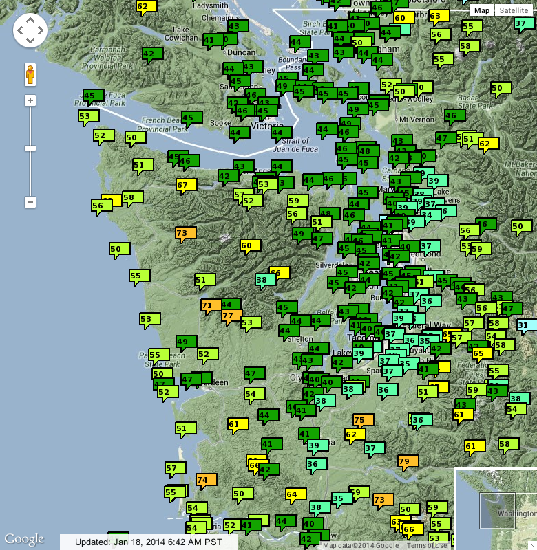
The coldest highs in the 30s °F are almost all clustered along the lowlands east of Puget Sound, with warmer highs in the 40s °F closer to the water throughout Puget Sound. But along the Washington coast, the highs are much warmer than in Puget Sound, in the 50s °F. And the warmest highs are found along the foothills and lower mountain slopes in both the Olympics and Cascades, mostly above 60 °F and some nearly hitting 80 °F. What on earth is going on??
Here is a summary of high and low temperatures within and adjacent to Mount Rainier National Park on January 16-17:
[tt]
Jan 16 Jan 17
Site Elevation Lo Hi Lo Hi Notes
Camp Muir 10110 ft 34 43 36 43
Sunrise 6410 ft 39 52 46 59 Located on a broad ridge
Crystal Mtn Top 6830 ft 38 48 44 54 Located atop a sharp ridge
Crystal Green Valley 6230 ft 34 43 35 48 Located within a wide basin
Crystal Mtn Base 4570 ft 33 37 33 39 Located within a valley
Cayuse Pass SNOTEL 5240 ft 42 54 47 58 Above Cayuse Pass near SR 410 switchback
Paradise NWAC 5400 ft 39 65 47 69
Paradise SNOTEL 5130 ft 36 48 44 61 0.6 mile SW of Paradise visitor center
Mowich SNOTEL 3160 ft 46 59 51 67 Atop a ridge outside Mowich entrance
Longmire 2760 ft 30 39 31 -- Located within a deep valley
[/tt]
Such a bizarre assortment of high and low temperatures within a small region!
So what makes the mountains and foothills so warm under these conditions, while leaving the valleys icy cold? There is now a strong ridge of upper-level high pressure over the West Coast and extending as far north as eastern Alaska and Yukon on the 17th. Here is the ridge as of Friday afternoon as seen on the UW WRF-GFS model :
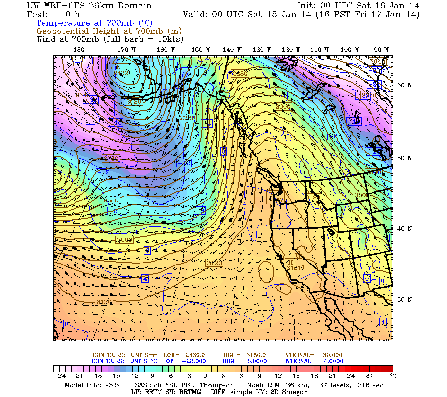
(The blue numbers are temperatures in °C at roughly 10,000 ft elevation, or more precisely, at the elevations shown as 4-digit numbers in meters.)
Upper-level high pressure basically means that air is sinking at mid and upper levels of the troposphere (call it very roughly 5,000-30,000 ft in this case) due to the influence of large-scale atmospheric circulation patterns. The sinking air warms due to adiabatic heating , which is a consequence of the ideal gas law, PV = nRT, because the pressure increases lower down in the atmosphere.
When unsaturated air (less than 100% relative humidity) rises or descends, its temperature changes at an approximate rate (assuming all other things being constant, rapid-enough motion, etc.) known as the dry adiabatic lapse rate (DALR), which is 5.4 °F per 1000 ft. This makes the air in the lower mountains and foothills very warm as it sinks downward, but lower down in the valleys, cold air is trapped and can't go anywhere quickly, so the warming air can only descend so far. The valleys and lowlands thus remain cold (and the wintertime sun is too weak and low-angle to effectively warm them), while the highest temperatures are found on lower mountain slopes and foothills.
In addition to that large-scale warming effect of sinking air, there is an additional local warming effect due to downslope winds below mountain slopes, similar to the well-known Chinook wind and Foehn wind . This effect is causing the warming along the Washington coast, and may be contributing to making Paradise so much warmer than other mountain sites. The current NNW flow at upper levels over WA (see wind barbs on the graphic above) is caused by the ridge adjacent to the coast, resulting in unusual winds flowing from Muir towards Paradise (which does not happen under other normal circumstances). Dry air flowing downslope from Camp Muir to Paradise (10100 - 5400 ft = 4700 ft drop) should warm by roughly 4.7 x 5.4 = 25 °F! Which is almost exactly the temperature difference between those two sites that the telemetry shows during the afternoons of January 16 and 17:
[tt][size=small]
Northwest Avalanche Center Northwest Avalanche Center
Paradise, Mt Rainier National Park, Washington Camp Muir, Mt Rainier National Park, Washington
Wind speed not reliable and may record periodically Wind gages unheated and may rime
24 hr snow board broken and to be repaired late Jan'14
MM/DD Hour Temp RH Wind Wind Wind Hour Total 24 Hr Total Solar MM/DD Hour Temp RH Wind Wind Wind Wind Solar
PST F % Avg Max Dir Prec. Prec. Snow Snow W/m2 PST F % Min Avg Max Dir W/m2
5400' 5400' 5380' 5380' 5380' 5400' 5400' 5400' 5400' 5400' 10110' 10110' 10110' 10110' 10110' 10110' 10110'
1 16 500 41 50 0 0 337 0 0 88 97 0 1 16 500 39 18 8 14 18 238 0
1 16 600 39 66 0 0 338 0 0 87 96 0 1 16 600 37 22 13 17 21 241 0
1 16 700 39 60 0 0 12 0 0 85 96 0 1 16 700 34 26 2 9 16 231 0
1 16 800 40 59 0 0 18 0 0 83 96 4 1 16 800 35 22 0 5 16 146 9
1 16 900 41 59 0 0 20 0 0 80 95 59 1 16 900 36 21 0 3 9 179 74
1 16 1000 46 57 0 0 21 0 0 79 96 203 1 16 1000 38 19 0 2 6 164 92
1 16 1100 49 51 0 0 18 0 0 73 95 347 1 16 1100 38 26 0 2 6 178 205
1 16 1200 50 55 0 0 13 0 0 83 94 391 1 16 1200 42 9 1 6 16 230 423
1 16 1300 52 57 0 0 9 0 0 79 94 369 1 16 1300 43 7 4 9 23 190 436
1 16 1400 61 32 0 0 10 0 0 80 95 340 1 16 1400 40 7 8 14 19 221 333
1 16 1500 65 30 0 0 11 0 0 78 94 332 1 16 1500 40 8 9 17 22 225 353
1 16 1600 52 48 0 0 11 0 0 75 95 182 1 16 1600 38 9 10 19 31 228 180
1 16 1700 45 61 0 0 334 0 0 73 95 47 1 16 1700 37 10 7 14 23 220 46
1 16 1800 45 47 0 0 358 0 0 76 95 0 1 16 1800 37 6 13 19 24 223 0
1 16 1900 45 50 0 0 20 0 0 78 96 0 1 16 1900 38 10 11 18 23 228 0
1 16 2000 45 36 0 0 27 0 0 78 96 0 1 16 2000 39 9 13 16 22 218 0
1 16 2100 47 30 0 0 357 0 0 78 96 0 1 16 2100 39 10 5 14 25 217 0
1 16 2200 47 23 0 0 347 0 0 78 96 0 1 16 2200 38 9 4 11 23 194 0
1 16 2300 48 19 0 0 3 0 0 77 95 0 1 16 2300 37 10 3 9 17 218 0
1 17 0 47 18 0 0 16 0 0 77 95 0 1 17 0 38 7 2 9 20 206 0
1 17 100 47 18 0 0 19 0 0 77 95 0 1 17 100 37 7 3 9 24 196 0
1 17 200 47 14 0 0 16 0 0 77 95 0 1 17 200 39 7 4 10 26 208 0
1 17 300 48 13 0 0 20 0 0 77 96 0 1 17 300 39 9 3 9 18 205 0
1 17 400 49 12 0 0 30 0 0 76 95 0 1 17 400 39 7 7 12 20 217 0
1 17 500 50 10 0 0 28 0 0 76 95 0 1 17 500 36 12 12 16 21 218 0
1 17 600 48 11 0 0 17 0 0 75 95 0 1 17 600 37 12 16 22 28 233 0
1 17 700 49 9 0 0 16 0 0 76 95 0 1 17 700 37 10 14 20 23 226 0
1 17 800 50 8 0 0 353 0 0 78 96 3 1 17 800 37 10 14 19 24 230 9
1 17 900 55 8 0 0 352 0 0 68 96 90 1 17 900 38 12 14 22 28 230 101
1 17 1000 56 11 0 0 303 0 0 74 95 260 1 17 1000 39 10 11 21 26 232 165
1 17 1100 58 9 0 0 281 0 0 71 95 358 1 17 1100 40 12 9 15 21 230 243
1 17 1200 58 10 0 0 346 0 0 72 94 408 1 17 1200 41 10 7 14 19 229 423
1 17 1300 61 6 0 0 17 0 0 71 94 465 1 17 1300 41 8 2 7 17 195 474
1 17 1400 67 6 0 0 76 0 0 72 93 419 1 17 1400 43 8 1 6 13 143 426
1 17 1500 69 5 0 0 46 0 0 72 93 339 1 17 1500 43 9 0 7 16 154 338
1 17 1600 62 8 0 0 133 0 0 68 93 215 1 17 1600 40 8 6 11 16 215 181
1 17 1700 53 11 0 0 20 0 0 67 94 47 1 17 1700 39 7 5 11 17 223 42
1 17 1800 52 10 0 0 25 0 0 71 94 0 1 17 1800 38 6 4 9 16 200 0
1 17 1900 51 10 0 0 21 0 0 62 94 0 1 17 1900 38 6 2 6 9 204 0
1 17 2000 51 9 0 0 28 0 0 64 94 0 1 17 2000 39 7 2 6 11 203 0
1 17 2100 51 10 0 0 25 0 0 64 94 0 1 17 2100 36 6 0 3 7 232 0
1 17 2200 52 9 0 0 16 0 0 64 94 0 1 17 2200 37 6 0 2 6 229 0
1 17 2300 50 10 0 0 7 0 0 64 94 0 1 17 2300 36 8 0 1 4 213 0
[/size][/tt]
There is another independent telemetry site nearby, the Paradise SNOTEL , which provides a separate set of temperature data to compare with. Interestingly, the temperatures are much lower at this site on the 16th (only reaching 48 °F), but do reach 61 °F on the 17th. It appears that the sinking air and downslope-flow heating effects were insufficient to reach the extra 300 ft lower to this less-exposed site on the 16th, but did begin to do so on the 17th:
[tt][size=small]
PARADISE SNOTEL 5130 ft
Located 0.6 mile SW of Paradise visitor center
Snow Precip
Water Snow since Air
Date / Time Equiv Depth Oct 1 Temp
(PST) (in) (in) (in) (°F)
2014-01-16 00:00 30.1 82 38.4 37
2014-01-16 01:00 30.0 82 38.5 36
2014-01-16 02:00 30.1 82 38.5 36
2014-01-16 03:00 30.1 81 38.5 36
2014-01-16 04:00 30.1 80 38.5 36
2014-01-16 05:00 30.1 81 38.5 36
2014-01-16 06:00 30.2 81 38.4 36
2014-01-16 07:00 30.1 81 38.5 36
2014-01-16 08:00 30.2 81 38.5 37
2014-01-16 09:00 30.2 81 38.4 37
2014-01-16 10:00 30.2 81 38.4 41
2014-01-16 11:00 30.2 80 38.5 43
2014-01-16 12:00 30.2 81 38.4 45
2014-01-16 13:00 30.2 80 38.4 48
2014-01-16 14:00 30.2 80 38.5 46
2014-01-16 16:00 30.4 81 38.4 45
2014-01-16 17:00 30.4 81 38.4 41
2014-01-16 18:00 30.4 80 38.4 41
2014-01-16 19:00 30.2 80 38.4 44
2014-01-16 20:00 30.4 81 38.4 41
2014-01-16 21:00 30.2 80 38.4 45
2014-01-16 22:00 30.4 80 38.4 45
2014-01-16 23:00 30.4 80 38.4 45
2014-01-17 00:00 30.4 80 38.4 44
2014-01-17 01:00 30.4 80 38.4 44
2014-01-17 02:00 30.4 80 38.4 45
2014-01-17 03:00 30.2 80 38.4 45
2014-01-17 04:00 30.3 80 38.4 46
2014-01-17 05:00 30.3 80 38.4 47
2014-01-17 06:00 30.3 80 38.4 46
2014-01-17 07:00 30.3 81 38.4 47
2014-01-17 08:00 30.3 80 38.4 48
2014-01-17 09:00 30.3 81 38.4 50
2014-01-17 10:00 30.3 80 38.4 53
2014-01-17 11:00 30.2 79 38.4 59
2014-01-17 12:00 30.4 81 38.4 57
2014-01-17 13:00 30.4 79 38.4 61
2014-01-17 14:00 30.2 80 38.4 59
2014-01-17 15:00 30.4 80 38.4 58
2014-01-17 16:00 30.3 80 38.4 55
2014-01-17 17:00 30.5 80 38.4 49
2014-01-17 18:00 30.5 80 38.5 51
2014-01-17 19:00 30.4 79 38.4 48
2014-01-17 20:00 30.4 80 38.4 48
2014-01-17 21:00 30.4 80 38.4 49
2014-01-17 22:00 30.4 80 38.4 50
2014-01-17 23:00 30.5 80 38.4 49
[/size][/tt]
Here is the data from Sunrise too, which also shows temps in the upper 50s °F:
[tt][size=small]
Northwest Avalanche Center
Sunrise, Mount Rainier National Park, Washington
Wind gages unheated and may rime
Prec. gage out for season
MM/DD Hour Temp Temp RH RH Wind Wind Wind Hour Total Total
PST F F % % Avg Max Dir Prec. Prec. Snow
6880' 6410' 6880' 6410' 6880' 6880' 6880' 6410' 6410' 6410'
1 16 500 40 54 0 38
1 16 600 39 61 0 38
1 16 700 40 57 0 37
1 16 800 46 50 0 37
1 16 900 47 48 0 38
1 16 1000 47 46 0 38
1 16 1100 52 35 0 38
1 16 1200 51 42 0 36
1 16 1300 50 42 0 37
1 16 1400 51 30 0 37
1 16 1500 51 38 0 36
1 16 1600 47 26 0&nb
First of all, there has been quite an amazing contrast in high temperatures in western Washington between the lowlands (in the 30s-40s °F, lowest in the fog belt) versus the foothills and lower mountain slopes (60s-70s °F). This is a plot of high temperatures for January 17 from Mesowest (which collects telemetry from many different networks of sites including NWAC, SNOTEL, RAWS, AgriMet, DOT, airports, railroads, etc.), go to www.wrh.noaa.gov/mesowest/gmap.php?map=sew , select "24 hr Max/Min", "24Hr Max Temp", and set "Density" to 2x:
The coldest highs in the 30s °F are almost all clustered along the lowlands east of Puget Sound, with warmer highs in the 40s °F closer to the water throughout Puget Sound. But along the Washington coast, the highs are much warmer than in Puget Sound, in the 50s °F. And the warmest highs are found along the foothills and lower mountain slopes in both the Olympics and Cascades, mostly above 60 °F and some nearly hitting 80 °F. What on earth is going on??
Here is a summary of high and low temperatures within and adjacent to Mount Rainier National Park on January 16-17:
[tt]
Jan 16 Jan 17
Site Elevation Lo Hi Lo Hi Notes
Camp Muir 10110 ft 34 43 36 43
Sunrise 6410 ft 39 52 46 59 Located on a broad ridge
Crystal Mtn Top 6830 ft 38 48 44 54 Located atop a sharp ridge
Crystal Green Valley 6230 ft 34 43 35 48 Located within a wide basin
Crystal Mtn Base 4570 ft 33 37 33 39 Located within a valley
Cayuse Pass SNOTEL 5240 ft 42 54 47 58 Above Cayuse Pass near SR 410 switchback
Paradise NWAC 5400 ft 39 65 47 69
Paradise SNOTEL 5130 ft 36 48 44 61 0.6 mile SW of Paradise visitor center
Mowich SNOTEL 3160 ft 46 59 51 67 Atop a ridge outside Mowich entrance
Longmire 2760 ft 30 39 31 -- Located within a deep valley
[/tt]
Such a bizarre assortment of high and low temperatures within a small region!
So what makes the mountains and foothills so warm under these conditions, while leaving the valleys icy cold? There is now a strong ridge of upper-level high pressure over the West Coast and extending as far north as eastern Alaska and Yukon on the 17th. Here is the ridge as of Friday afternoon as seen on the UW WRF-GFS model :
(The blue numbers are temperatures in °C at roughly 10,000 ft elevation, or more precisely, at the elevations shown as 4-digit numbers in meters.)
Upper-level high pressure basically means that air is sinking at mid and upper levels of the troposphere (call it very roughly 5,000-30,000 ft in this case) due to the influence of large-scale atmospheric circulation patterns. The sinking air warms due to adiabatic heating , which is a consequence of the ideal gas law, PV = nRT, because the pressure increases lower down in the atmosphere.
When unsaturated air (less than 100% relative humidity) rises or descends, its temperature changes at an approximate rate (assuming all other things being constant, rapid-enough motion, etc.) known as the dry adiabatic lapse rate (DALR), which is 5.4 °F per 1000 ft. This makes the air in the lower mountains and foothills very warm as it sinks downward, but lower down in the valleys, cold air is trapped and can't go anywhere quickly, so the warming air can only descend so far. The valleys and lowlands thus remain cold (and the wintertime sun is too weak and low-angle to effectively warm them), while the highest temperatures are found on lower mountain slopes and foothills.
In addition to that large-scale warming effect of sinking air, there is an additional local warming effect due to downslope winds below mountain slopes, similar to the well-known Chinook wind and Foehn wind . This effect is causing the warming along the Washington coast, and may be contributing to making Paradise so much warmer than other mountain sites. The current NNW flow at upper levels over WA (see wind barbs on the graphic above) is caused by the ridge adjacent to the coast, resulting in unusual winds flowing from Muir towards Paradise (which does not happen under other normal circumstances). Dry air flowing downslope from Camp Muir to Paradise (10100 - 5400 ft = 4700 ft drop) should warm by roughly 4.7 x 5.4 = 25 °F! Which is almost exactly the temperature difference between those two sites that the telemetry shows during the afternoons of January 16 and 17:
[tt][size=small]
Northwest Avalanche Center Northwest Avalanche Center
Paradise, Mt Rainier National Park, Washington Camp Muir, Mt Rainier National Park, Washington
Wind speed not reliable and may record periodically Wind gages unheated and may rime
24 hr snow board broken and to be repaired late Jan'14
MM/DD Hour Temp RH Wind Wind Wind Hour Total 24 Hr Total Solar MM/DD Hour Temp RH Wind Wind Wind Wind Solar
PST F % Avg Max Dir Prec. Prec. Snow Snow W/m2 PST F % Min Avg Max Dir W/m2
5400' 5400' 5380' 5380' 5380' 5400' 5400' 5400' 5400' 5400' 10110' 10110' 10110' 10110' 10110' 10110' 10110'
1 16 500 41 50 0 0 337 0 0 88 97 0 1 16 500 39 18 8 14 18 238 0
1 16 600 39 66 0 0 338 0 0 87 96 0 1 16 600 37 22 13 17 21 241 0
1 16 700 39 60 0 0 12 0 0 85 96 0 1 16 700 34 26 2 9 16 231 0
1 16 800 40 59 0 0 18 0 0 83 96 4 1 16 800 35 22 0 5 16 146 9
1 16 900 41 59 0 0 20 0 0 80 95 59 1 16 900 36 21 0 3 9 179 74
1 16 1000 46 57 0 0 21 0 0 79 96 203 1 16 1000 38 19 0 2 6 164 92
1 16 1100 49 51 0 0 18 0 0 73 95 347 1 16 1100 38 26 0 2 6 178 205
1 16 1200 50 55 0 0 13 0 0 83 94 391 1 16 1200 42 9 1 6 16 230 423
1 16 1300 52 57 0 0 9 0 0 79 94 369 1 16 1300 43 7 4 9 23 190 436
1 16 1400 61 32 0 0 10 0 0 80 95 340 1 16 1400 40 7 8 14 19 221 333
1 16 1500 65 30 0 0 11 0 0 78 94 332 1 16 1500 40 8 9 17 22 225 353
1 16 1600 52 48 0 0 11 0 0 75 95 182 1 16 1600 38 9 10 19 31 228 180
1 16 1700 45 61 0 0 334 0 0 73 95 47 1 16 1700 37 10 7 14 23 220 46
1 16 1800 45 47 0 0 358 0 0 76 95 0 1 16 1800 37 6 13 19 24 223 0
1 16 1900 45 50 0 0 20 0 0 78 96 0 1 16 1900 38 10 11 18 23 228 0
1 16 2000 45 36 0 0 27 0 0 78 96 0 1 16 2000 39 9 13 16 22 218 0
1 16 2100 47 30 0 0 357 0 0 78 96 0 1 16 2100 39 10 5 14 25 217 0
1 16 2200 47 23 0 0 347 0 0 78 96 0 1 16 2200 38 9 4 11 23 194 0
1 16 2300 48 19 0 0 3 0 0 77 95 0 1 16 2300 37 10 3 9 17 218 0
1 17 0 47 18 0 0 16 0 0 77 95 0 1 17 0 38 7 2 9 20 206 0
1 17 100 47 18 0 0 19 0 0 77 95 0 1 17 100 37 7 3 9 24 196 0
1 17 200 47 14 0 0 16 0 0 77 95 0 1 17 200 39 7 4 10 26 208 0
1 17 300 48 13 0 0 20 0 0 77 96 0 1 17 300 39 9 3 9 18 205 0
1 17 400 49 12 0 0 30 0 0 76 95 0 1 17 400 39 7 7 12 20 217 0
1 17 500 50 10 0 0 28 0 0 76 95 0 1 17 500 36 12 12 16 21 218 0
1 17 600 48 11 0 0 17 0 0 75 95 0 1 17 600 37 12 16 22 28 233 0
1 17 700 49 9 0 0 16 0 0 76 95 0 1 17 700 37 10 14 20 23 226 0
1 17 800 50 8 0 0 353 0 0 78 96 3 1 17 800 37 10 14 19 24 230 9
1 17 900 55 8 0 0 352 0 0 68 96 90 1 17 900 38 12 14 22 28 230 101
1 17 1000 56 11 0 0 303 0 0 74 95 260 1 17 1000 39 10 11 21 26 232 165
1 17 1100 58 9 0 0 281 0 0 71 95 358 1 17 1100 40 12 9 15 21 230 243
1 17 1200 58 10 0 0 346 0 0 72 94 408 1 17 1200 41 10 7 14 19 229 423
1 17 1300 61 6 0 0 17 0 0 71 94 465 1 17 1300 41 8 2 7 17 195 474
1 17 1400 67 6 0 0 76 0 0 72 93 419 1 17 1400 43 8 1 6 13 143 426
1 17 1500 69 5 0 0 46 0 0 72 93 339 1 17 1500 43 9 0 7 16 154 338
1 17 1600 62 8 0 0 133 0 0 68 93 215 1 17 1600 40 8 6 11 16 215 181
1 17 1700 53 11 0 0 20 0 0 67 94 47 1 17 1700 39 7 5 11 17 223 42
1 17 1800 52 10 0 0 25 0 0 71 94 0 1 17 1800 38 6 4 9 16 200 0
1 17 1900 51 10 0 0 21 0 0 62 94 0 1 17 1900 38 6 2 6 9 204 0
1 17 2000 51 9 0 0 28 0 0 64 94 0 1 17 2000 39 7 2 6 11 203 0
1 17 2100 51 10 0 0 25 0 0 64 94 0 1 17 2100 36 6 0 3 7 232 0
1 17 2200 52 9 0 0 16 0 0 64 94 0 1 17 2200 37 6 0 2 6 229 0
1 17 2300 50 10 0 0 7 0 0 64 94 0 1 17 2300 36 8 0 1 4 213 0
[/size][/tt]
There is another independent telemetry site nearby, the Paradise SNOTEL , which provides a separate set of temperature data to compare with. Interestingly, the temperatures are much lower at this site on the 16th (only reaching 48 °F), but do reach 61 °F on the 17th. It appears that the sinking air and downslope-flow heating effects were insufficient to reach the extra 300 ft lower to this less-exposed site on the 16th, but did begin to do so on the 17th:
[tt][size=small]
PARADISE SNOTEL 5130 ft
Located 0.6 mile SW of Paradise visitor center
Snow Precip
Water Snow since Air
Date / Time Equiv Depth Oct 1 Temp
(PST) (in) (in) (in) (°F)
2014-01-16 00:00 30.1 82 38.4 37
2014-01-16 01:00 30.0 82 38.5 36
2014-01-16 02:00 30.1 82 38.5 36
2014-01-16 03:00 30.1 81 38.5 36
2014-01-16 04:00 30.1 80 38.5 36
2014-01-16 05:00 30.1 81 38.5 36
2014-01-16 06:00 30.2 81 38.4 36
2014-01-16 07:00 30.1 81 38.5 36
2014-01-16 08:00 30.2 81 38.5 37
2014-01-16 09:00 30.2 81 38.4 37
2014-01-16 10:00 30.2 81 38.4 41
2014-01-16 11:00 30.2 80 38.5 43
2014-01-16 12:00 30.2 81 38.4 45
2014-01-16 13:00 30.2 80 38.4 48
2014-01-16 14:00 30.2 80 38.5 46
2014-01-16 16:00 30.4 81 38.4 45
2014-01-16 17:00 30.4 81 38.4 41
2014-01-16 18:00 30.4 80 38.4 41
2014-01-16 19:00 30.2 80 38.4 44
2014-01-16 20:00 30.4 81 38.4 41
2014-01-16 21:00 30.2 80 38.4 45
2014-01-16 22:00 30.4 80 38.4 45
2014-01-16 23:00 30.4 80 38.4 45
2014-01-17 00:00 30.4 80 38.4 44
2014-01-17 01:00 30.4 80 38.4 44
2014-01-17 02:00 30.4 80 38.4 45
2014-01-17 03:00 30.2 80 38.4 45
2014-01-17 04:00 30.3 80 38.4 46
2014-01-17 05:00 30.3 80 38.4 47
2014-01-17 06:00 30.3 80 38.4 46
2014-01-17 07:00 30.3 81 38.4 47
2014-01-17 08:00 30.3 80 38.4 48
2014-01-17 09:00 30.3 81 38.4 50
2014-01-17 10:00 30.3 80 38.4 53
2014-01-17 11:00 30.2 79 38.4 59
2014-01-17 12:00 30.4 81 38.4 57
2014-01-17 13:00 30.4 79 38.4 61
2014-01-17 14:00 30.2 80 38.4 59
2014-01-17 15:00 30.4 80 38.4 58
2014-01-17 16:00 30.3 80 38.4 55
2014-01-17 17:00 30.5 80 38.4 49
2014-01-17 18:00 30.5 80 38.5 51
2014-01-17 19:00 30.4 79 38.4 48
2014-01-17 20:00 30.4 80 38.4 48
2014-01-17 21:00 30.4 80 38.4 49
2014-01-17 22:00 30.4 80 38.4 50
2014-01-17 23:00 30.5 80 38.4 49
[/size][/tt]
Here is the data from Sunrise too, which also shows temps in the upper 50s °F:
[tt][size=small]
Northwest Avalanche Center
Sunrise, Mount Rainier National Park, Washington
Wind gages unheated and may rime
Prec. gage out for season
MM/DD Hour Temp Temp RH RH Wind Wind Wind Hour Total Total
PST F F % % Avg Max Dir Prec. Prec. Snow
6880' 6410' 6880' 6410' 6880' 6880' 6880' 6410' 6410' 6410'
1 16 500 40 54 0 38
1 16 600 39 61 0 38
1 16 700 40 57 0 37
1 16 800 46 50 0 37
1 16 900 47 48 0 38
1 16 1000 47 46 0 38
1 16 1100 52 35 0 38
1 16 1200 51 42 0 36
1 16 1300 50 42 0 37
1 16 1400 51 30 0 37
1 16 1500 51 38 0 36
1 16 1600 47 26 0&nb
Please Log in or Create an account to join the conversation.
- blackdog102395
-
- User
-
Less
More
- Posts: 161
- Thank you received: 1
12 years 5 months ago #219783
by blackdog102395
Replied by blackdog102395 on topic Re: Paradise telemetry 65 degrees at 3:00 pm!!
These temperatures blow my mind. How rare is it to approach 70 degrees at Paradise in January?
Please Log in or Create an account to join the conversation.