- Posts: 635
- Thank you received: 0
New snowfall on Rainier, Oct 2012: webcam photos!
- Amar Andalkar
-
 Topic Author
- User
-

Less
More
13 years 8 months ago #206600
by Amar Andalkar
New snowfall on Rainier, Oct 2012: webcam photos! was created by Amar Andalkar
A brief period of clear skies on Monday morning allowed a nice view of the new snowfall on Mount Rainier over the last few days. This animation of a pair of images from the Paradise Mountain webcam (
www.nps.gov/webcams-mora/mountain.jpg
) shows conditions at 10:40am on October 15 and the same time on October 11, the last day of our glorious extended Northwest summer. The lowest rock visible in the image is the bottom of Wilson Cleaver at about 8500 ft, and accumulating snowfall has occurred down to that elevation and lower:
Full size version: www.skimountaineer.com/TR/Images2012/mountain-2012Oct11+15.gif
The Camp Muir webcam ( www.nps.gov/webcams-mora/muir.jpg ) has been back online since October 4, after an outage since November 20, 2011, caused by physical damage from repeated impacts. It has been upgraded to a higher resolution (3 MP) and now updates every 10 minutes instead of hourly, since it transmits over the new higher-speed NPS link to the Muir ranger hut, instead of the slow NWAC telemetry link. As expected, the camera rapidly iced up during the storm, but the ice cleared off on its own about an hour before sunset on Monday, enough to see a few images. This animation of a pair of images shows conditions at 5:40pm on October 15 and at noon on October 11, the last clear day. Looks like the snow drifts are 3-4 ft deep in spots:
Full size version: www.skimountaineer.com/TR/Images2012/muir-2012Oct11+15.gif (which is actually reduced 50% from the original, except the timestamp which is 100% to maintain legibility)
(I made these animations just for fun, to show to a friend of mine, each took only a few minutes to create in Photoshop.)
Please Log in or Create an account to join the conversation.
- Amar Andalkar
-
Topic Author
- User
-
Less
More
- Posts: 635
- Thank you received: 0
13 years 8 months ago - 13 years 8 months ago #206603
by Amar Andalkar
Replied by Amar Andalkar on topic Re: New snowfall on Rainier, Oct 2012: webcam photos!
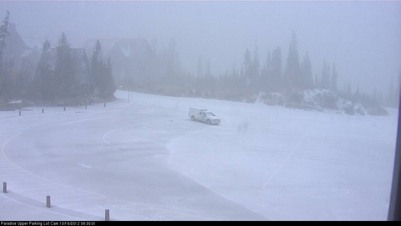
The snow level dropped from 10000 ft overnight down to 5000 ft at Rainier this morning, and the Paradise East webcam (
www.nps.gov/webcams-mora/east.jpg
) caught the parking lot at 5400 ft fully snowcovered for a brief period, before sunbreaks and the warmth of the ground melted it away:
Here is yesterday evening's Rainier forecast for reference:
[tt]MOUNT RAINIER RECREATIONAL FORECAST
NATIONAL WEATHER SERVICE SEATTLE WA
404 PM PDT MON OCT 15 2012
SYNOPSIS...A VIGOROUS FRONT WILL BRING MORE RAIN AND WIND TONIGHT. DECREASING SHOWERS WILL FOLLOW ON TUESDAY AS AN UPPER TROUGH MOVES THROUGH. DRY WEATHER IS LIKELY WEDNESDAY INTO THURSDAY. ANOTHER FRONT WILL MOVE THROUGH AROUND THURSDAY NIGHT WITH COOL SHOWERY WEATHER LIKELY THIS WEEKEND.
MONDAY NIGHT...ISOLATED THUNDERSTORMS. RAIN AND SNOW EARLY THIS EVENING...THEN SHOWERS IN THE LATE EVENING AND OVERNIGHT. BREEZY. PRECIPITATION MAY BE HEAVY AT TIMES EARLY THIS EVENING. SNOW LEVEL 10000 FEET.
TUESDAY...SHOWERS...BREEZY. TOTAL SNOW ACCUMULATION UP TO 6 INCHES. SNOW LEVEL 5000 FEET.
TUESDAY NIGHT...SHOWERS LIKELY IN THE EVENING...THEN MOSTLY CLOUDY WITH A CHANCE OF SHOWERS AFTER MIDNIGHT. BREEZY. SNOW LEVEL 4500 FEET.
WEDNESDAY...PARTLY SUNNY. FREEZING LEVEL 5500 FEET.
TEMPERATURE AND WIND FORECASTS FOR SELECTED LOCATIONS.
MON TUE TUE WED
NIGHT NIGHT
SUMMIT (14411 FT) 7 0 12 18
W 74 NW 66 NW 67 NW 47
CAMP MUIR(10188 FT) 23 13 19 26
W 52 W 46 NW 41 NW 23
PARADISE (5420 FT) 35 38 29 42
SW 14 W 16 W 12 NW 4
LONGMIRE (2700 FT) 41 45 34 50
SW 14 W 15 W 11 NW 3
++ TEMPERATURES AND WIND FOR THE SUMMIT AND CAMP MUIR ARE AVERAGE
CONDITIONS EXPECTED IN THE FREE AIR AT THOSE ELEVATIONS.
++ TEMPERATURES FOR PARADISE AND LONGMIRE ARE THE EXPECTED HIGHS AND
LOWS. WIND IS THE AVERAGE WIND EXPECTED DURING THAT PERIOD.
EXTENDED FORECAST...
WEDNESDAY NIGHT AND THURSDAY...MOSTLY CLOUDY. FREEZING LEVEL 9000 FEET.
THURSDAY NIGHT...RAIN AND SNOW LIKELY. SNOW LEVEL 9500 FEET.
FRIDAY...SHOWERS LIKELY. BREEZY. SNOW LEVEL 7500 FEET.
FRIDAY NIGHT AND SATURDAY...SHOWERS. SNOW LEVEL 4000 FEET.
SATURDAY NIGHT...SHOWERS LIKELY. LOCALLY HEAVY RAINFALL POSSIBLE. SNOW LEVEL 4500 FEET.
SUNDAY...SHOWERS LIKELY. BREEZY. SNOW LEVEL 3000 FEET.
SUNDAY NIGHT AND MONDAY...CLOUDY WITH A CHANCE OF SHOWERS. SNOW LEVEL 3000 FEET.
[/tt]
The NWAC telemetry from Paradise and Camp Muir nicely shows the frontal passage and roughly 20 °F temperature drop:
[tt]10-16-2012
Northwest Weather and Avalanche Center
Paradise, Mt Rainier National Park, Washington
MM/DD Hour Temp RH Wind Wind Wind Hour Total 24 Hr Total Solar
PST F % Avg Max Dir Prec. Prec. Snow Snow W/m2
5400' 5400' 5380' 5380' 5380' 5400' 5400' 5400' 5400' 5400'
10 15 900 41 94 14 21 277 0 0 2 13 116
10 15 1000 42 93 13 18 281 0 0 3 13 162
10 15 1100 43 91 16 23 280 0 0 2 10 173
10 15 1200 45 86 13 21 279 0 0 2 15 172
10 15 1300 43 88 9 18 277 0 0 3 12 65
10 15 1400 45 98 8 13 276 .14 .14 1 11 26
10 15 1500 46 99 10 18 264 .12 .26 2 12 7
10 15 1600 47 99 11 15 272 .32 .58 1 10 1
10 15 1700 47 99 14 25 269 .31 .89 1 9 2
10 15 1800 49 100 21 32 270 .36 1.25 1 3 0
10 15 1900 49 100 23 36 268 .05 1.3 1 8 0
10 15 2000 49 100 24 34 269 .03 1.33 1 5 0
10 15 2100 47 100 27 45 271 .08 1.41 1 11 0
10 15 2200 47 100 24 34 269 .05 1.46 2 10 0
10 15 2300 46 100 22 33 264 .04 1.5 3 10 0
10 16 0 44 100 25 40 272 .03 1.53 3 11 0
10 16 100 41 99 30 47 271 .03 1.56 1 12 0
10 16 200 38 99 24 40 264 .01 1.57 3 14 0
10 16 300 36 99 26 52 267 .1 1.67 3 13 0
10 16 400 33 99 37 60 273 .01 1.68 3 15 0
10 16 500 32 100 32 62 274 .01 1.69 3 11 0
10 16 600 30 95 35 57 273 0 1.69 1 13 0
10 16 700 30 99 20 34 268 .01 1.7 1 11 1
10 16 800 29 99 21 38 267 .04 1.74 1 12 30
Northwest Weather and Avalanche Center
Camp Muir, Mt Rainier National Park, Washington
Wind gages unheated and may rime
MM/DD Hour Temp RH Wind Wind Wind Wind Solar
PST F % Min Avg Max Dir W/m2
10110' 10110' 10110' 10110' 10110' 10110' 10110'
10 15 900 29 65 0 0 0 226 402
10 15 1000 28 68 0 0 0 249 469
10 15 1100 27 62 0 0 0 267 395
10 15 1200 29 73 0 0 0 268 256
10 15 1300 30 100 0 0 0 268 86
10 15 1400 32 100 0 0 0 263 59
10 15 1500 32 100 0 0 0 244 23
10 15 1600 33 100 0 0 0 226 11
10 15 1700 34 100 0 0 0 239 9
10 15 1800 35 100 0 0 0 230 1
10 15 1900 34 100 0 70 101 240 0
10 15 2000 32 100 42 73 100 247 0
10 15 2100 31 100 42 74 94 248 0
10 15 2200 30 100 37 64 90 244 0
10 15 2300 29 100 21 37 56 253 0
10 16 0 29 100 20 31 43 253 0
10 16 100 24 100 19 32 45 253 0
10 16 200 22 100 13 23 33 253 0
10 16 300 21 99 4 17 26 253 0
10 16 400 16 98 9 20 30 253 0
10 16 500 15 97 4 21 30 253 0
10 16 600 12 96 12 20 26 253 0
10 16 700 13 97 3 13 21 253 11
10 16 800 12 95 0 5 18 253 103
[/tt]
Please Log in or Create an account to join the conversation.
- BrianT
-
- User
-
Less
More
- Posts: 174
- Thank you received: 0
13 years 8 months ago #206604
by BrianT
Replied by BrianT on topic Re: New snowfall on Rainier, Oct 2012: webcam photos!
You coming tomorrow amar?
Please Log in or Create an account to join the conversation.
- Dustin_B
-
- User
-
Less
More
- Posts: 23
- Thank you received: 0
13 years 8 months ago #206605
by Dustin_B
Replied by Dustin_B on topic Re: New snowfall on Rainier, Oct 2012: webcam photos!
whats up with the anomalous 24-hour snow totals at Paradise starting on about the 12th. looking at the past 10-day telemetry for Paradise, 24-hr snow totals range from 1-4 inches with no consistency. The corresponding temps are way to warm for that to be snow obviously so its some kind of glitch I suppose.
Also just noticed the total snow, which is definitely not accurate as there is no accumulation or even left over snow from last year that low.
Also just noticed the total snow, which is definitely not accurate as there is no accumulation or even left over snow from last year that low.
Please Log in or Create an account to join the conversation.
- Charlie Hagedorn
-
- User
-
Less
More
- Posts: 913
- Thank you received: 1
13 years 8 months ago #206606
by Charlie Hagedorn
Replied by Charlie Hagedorn on topic Re: New snowfall on Rainier, Oct 2012: webcam photos!
Ullr and Amar deliver!
Even this late in the morning, Tahoma's not the only peak with webcam snow:
Even this late in the morning, Tahoma's not the only peak with webcam snow:
Please Log in or Create an account to join the conversation.
- Amar Andalkar
-
Topic Author
- User
-
Less
More
- Posts: 635
- Thank you received: 0
13 years 8 months ago #206607
by Amar Andalkar
Still trying to figure out my ski plans for Wednesday.
The total snowdepth gauge (a downward-looking ultrasonic distance sensor, mounted on an arm atop a 20-30 ft tower) generally reads bushes at most telemetry sites during early season. A quick glance through www.nwac.us/data/ALL shows that most sites have non-zero snowdepth readings, some up to 1-2 ft, even though none currently have snowpack. Sometimes in years past, some NWAC site data files have even had a message added stating that "Total snow sensor may measure bushes in early season".
The 24-hour gauge is a similar sensor mounted on a 4-ft post attached to a movable board, which must be manually cleared of snow. So depending on where that gauge has been left sitting, some other loose debris or plant material may have fallen on the board, giving the randomly varying false "depth" readings.
Replied by Amar Andalkar on topic Re: New snowfall on Rainier, Oct 2012: webcam photos!
You coming tomorrow amar?
Still trying to figure out my ski plans for Wednesday.
whats up with the anomalous 24-hour snow totals at Paradise starting on about the 12th. looking at the past 10-day telemetry for Paradise, 24-hr snow totals range from 1-4 inches with no consistency. The corresponding temps are way to warm for that to be snow obviously so its some kind of glitch I suppose.
Also just noticed the total snow, which is definitely not accurate as there is no accumulation or even left over snow from last year that low.
The total snowdepth gauge (a downward-looking ultrasonic distance sensor, mounted on an arm atop a 20-30 ft tower) generally reads bushes at most telemetry sites during early season. A quick glance through www.nwac.us/data/ALL shows that most sites have non-zero snowdepth readings, some up to 1-2 ft, even though none currently have snowpack. Sometimes in years past, some NWAC site data files have even had a message added stating that "Total snow sensor may measure bushes in early season".
The 24-hour gauge is a similar sensor mounted on a 4-ft post attached to a movable board, which must be manually cleared of snow. So depending on where that gauge has been left sitting, some other loose debris or plant material may have fallen on the board, giving the randomly varying false "depth" readings.
Please Log in or Create an account to join the conversation.