- Posts: 31
- Thank you received: 0
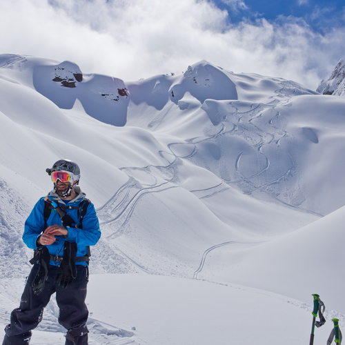
Silver Peak Route/Map
- thatoneguydave
-
 Topic Author
- User
-

Less
More
13 years 11 months ago #205854
by thatoneguydave
Silver Peak Route/Map was created by thatoneguydave
Planning on heading up tomorrow, but have never actually skied Silver Peak. Any info on the route? I'm assuming it's clear as day, but would rather have an idea prior. Trying to get my first year of turns all year with my wife AND see the Euro Cup Final tomorrow. Silver looks ideal for this.
Thanks!
Thanks!
Please Log in or Create an account to join the conversation.
- r1de
-
- User
-
Less
More
- Posts: 90
- Thank you received: 0
13 years 11 months ago #205856
by r1de
Replied by r1de on topic Re: Silver Peak Route/Map
Hey, did you end up finding it okay? I've only been there once myself, but it's pretty straight-forward. You go up the road on skins and keep watch to the left for tracks veering off toward the peak. You'll enter the bowl on the NW side. A topo map should help.
Please Log in or Create an account to join the conversation.
- thatoneguydave
-
Topic Author
- User
-
Less
More
- Posts: 31
- Thank you received: 0
13 years 11 months ago #205859
by thatoneguydave
Replied by thatoneguydave on topic Re: Silver Peak Route/Map
I like to make things complicated.
Started off on the PCT TH because I didn't fathom that the road would take me through all the brush and couldn't understand how one would bush whack the jungle at the bottom of the clearcut. SO....I went in on the PCT to the raging creek and followed to the snowline then met back up at the top of the clearcut and found the tracks and such to the peak.
On the way out I thought I learned my lesson so I followed my instincts through the snow in the clear cut, followed a bunch of tracks till they found portion of the road, but went towards a dead end in the road aiming at the PCT. Saw on my GPS I was about 500 ft from it so took my wife through some awesome bush whacking and navigating some soggy wetlands. After getting soaked through the brush and getting back to the PCT I soon realized I should have gone the other direction on the road and avoided the brush.
In the end...priceless. Oh and we saw a bear in the morning on the drive in on the road.
Please Log in or Create an account to join the conversation.
- mtngirl
-
- User
-
Less
More
- Posts: 14
- Thank you received: 0
13 years 11 months ago #205869
by mtngirl
Replied by mtngirl on topic Re: Silver Peak Route/Map
I am planning to go to Silver Peak for the first time Wednesday the 4th. Someone told me I can just drive up the road until I hit snow and start skinning. My Ski and Snowboard routes book has winter directions, that don't involve driving on a road, so can anyone tell me what road I am going to drive up? Then it sounds like I skin up until I see tracks going off to the left.
Can anyone weigh in on avi danger? It's my understanding that it's pretty consolidated, but I am not normally a late spring bc skier, so I don't have a ton of experience at this time of year.
Thanks!!
Can anyone weigh in on avi danger? It's my understanding that it's pretty consolidated, but I am not normally a late spring bc skier, so I don't have a ton of experience at this time of year.
Thanks!!
Please Log in or Create an account to join the conversation.
- JPH
-
- User
-
Less
More
- Posts: 165
- Thank you received: 1
13 years 11 months ago #205871
by JPH
Replied by JPH on topic Re: Silver Peak Route/Map
Mtngirl, It's like driving to Hyak, but you go past the parking lots and drive the road to windy pass (the saddle between Silver and Margaret).
I'd be more worried about getting crapped on by birds than avalanches at snoq pass at this point.
I'd be more worried about getting crapped on by birds than avalanches at snoq pass at this point.
Please Log in or Create an account to join the conversation.
- Jim Oker
-
- User
-
Less
More
- Posts: 901
- Thank you received: 0
13 years 11 months ago #205872
by Jim Oker
Replied by Jim Oker on topic Re: Silver Peak Route/Map
FR 9070 (Margaret is over on the other side of the highway by the way ") ). Drive as close to the pass as snow allows. There is a clearcut over on the north side of the pass - roughly follow its edge uphill (left off the road) until you get to the high point of the clearcut. You may need to wander around a bit down low to find the best way through the tree farm - at some point it will have melted enough that it's easiest to keep driving the road well up into the clearcut until you're blocked by snow or earth berm and walk/ski the road up to the high point (in some seasons I've also found that there is good snow on the south side of the creek in the woods from very close to the pass all the way up to where you can cross back over on snow bridges to the well-covered upper clearcut). From there most of us traverse around a rib to get into the NW lobe of the north basin. Topo map and navigational sense should help you here. Follow that up up up until the peak is above you and head right to gain the NW ridge. Some follow the ridge to the peak proper but many focus on the skiing opportunities at this point.
). Drive as close to the pass as snow allows. There is a clearcut over on the north side of the pass - roughly follow its edge uphill (left off the road) until you get to the high point of the clearcut. You may need to wander around a bit down low to find the best way through the tree farm - at some point it will have melted enough that it's easiest to keep driving the road well up into the clearcut until you're blocked by snow or earth berm and walk/ski the road up to the high point (in some seasons I've also found that there is good snow on the south side of the creek in the woods from very close to the pass all the way up to where you can cross back over on snow bridges to the well-covered upper clearcut). From there most of us traverse around a rib to get into the NW lobe of the north basin. Topo map and navigational sense should help you here. Follow that up up up until the peak is above you and head right to gain the NW ridge. Some follow the ridge to the peak proper but many focus on the skiing opportunities at this point.
I'm wary of giving much advice regarding avalanche hazard in general, but it sure did seem pretty well consolidated when I was up there on the solstice, and I think falling into unseen snowbridged holes or having a fall and sliding into rocks or trees is a bigger hazard on that route right now.
). Drive as close to the pass as snow allows. There is a clearcut over on the north side of the pass - roughly follow its edge uphill (left off the road) until you get to the high point of the clearcut. You may need to wander around a bit down low to find the best way through the tree farm - at some point it will have melted enough that it's easiest to keep driving the road well up into the clearcut until you're blocked by snow or earth berm and walk/ski the road up to the high point (in some seasons I've also found that there is good snow on the south side of the creek in the woods from very close to the pass all the way up to where you can cross back over on snow bridges to the well-covered upper clearcut). From there most of us traverse around a rib to get into the NW lobe of the north basin. Topo map and navigational sense should help you here. Follow that up up up until the peak is above you and head right to gain the NW ridge. Some follow the ridge to the peak proper but many focus on the skiing opportunities at this point.I'm wary of giving much advice regarding avalanche hazard in general, but it sure did seem pretty well consolidated when I was up there on the solstice, and I think falling into unseen snowbridged holes or having a fall and sliding into rocks or trees is a bigger hazard on that route right now.
Please Log in or Create an account to join the conversation.