- Posts: 158
- Thank you received: 0
Baker south side reports?
- samthaman
-
 Topic Author
- User
-

Less
More
14 years 1 month ago #205271
by samthaman
Baker south side reports? was created by samthaman
Anyone know where the snowline currently is? Are the sledders still active?
If the weather cooperates, I'm thinking of bringing my girlfriend and her friend up the south side this weekend, and I'd love to have a handle on how much of a road approach there will be.
Thanks in advance
sam
If the weather cooperates, I'm thinking of bringing my girlfriend and her friend up the south side this weekend, and I'd love to have a handle on how much of a road approach there will be.
Thanks in advance
sam
Please Log in or Create an account to join the conversation.
- nbsar
-
- User
-
Less
More
- Posts: 9
- Thank you received: 0
14 years 1 month ago #205274
by nbsar
Replied by nbsar on topic Re: Baker south side reports?
There is snow to the final switchback. Baker has the best spring riding in Washington State, so expect lots of sledders until the Forrest Service says no more. You can sneak up the Sauk side where it is a little quieter, or go just about anywhere else above tree line, where sleds are not allowed.
Please Log in or Create an account to join the conversation.
- snoholic
-
- User
-
Less
More
- Posts: 120
- Thank you received: 1
14 years 1 month ago #205282
by snoholic
Replied by snoholic on topic Re: Baker south side reports?
Saw sledders all the way up to the crater via the Easton on Friday. Is that legit?
Please Log in or Create an account to join the conversation.
- nbsar
-
- User
-
Less
More
- Posts: 9
- Thank you received: 0
14 years 1 month ago #205287
by nbsar
Replied by nbsar on topic Re: Baker south side reports?
That is usually legit. You can check the wilderness boundary on the USGS map.
Please Log in or Create an account to join the conversation.
- Amar Andalkar
-
- User
-
Less
More
- Posts: 635
- Thank you received: 0
14 years 1 month ago #205289
by Amar Andalkar
Wrong, it is never legit! Yes, you really should check the wilderness boundary on the USGS map. The legal snowmobile area goes nowhere near the crater, as the triangle of the Baker NRA tops out atop Sherman Peak.
Any snowmobile approaching the crater rim at the 9720 ft saddle west of Sherman Peak is more than 1500 ft inside the wilderness boundary. Even the large flat area where snowmobilers like to park and rest is over 600 ft inside the wilderness boundary.
See this map scanned from the official USFS Mount Baker Wilderness Map (2005) and annotated (originally posted in this TR: May 29, 2011, Mt Baker, Easton Above the Clouds ). The Wilderness boundary runs in a straight line from the cliffs which divide the Easton and Deming Glaciers up to the summit of Sherman Peak. This imaginary line is very easy to observe from any location above 7000 ft on the Easton or Deming, and any snowmobile seen to the west of this line is illegally trespassing.
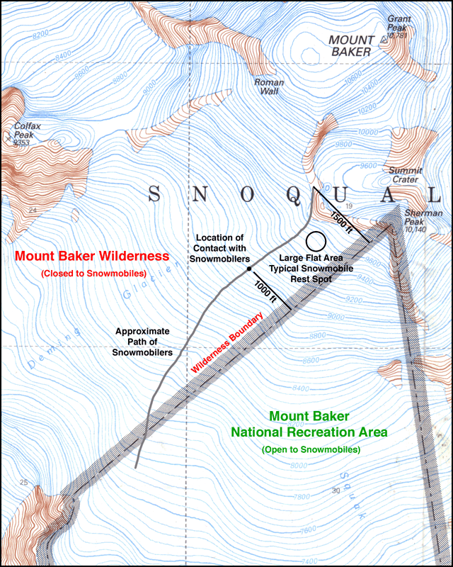
Everyone should be sick and tired of people driving their snowmobiles in illegal areas. If you want to go there, then park your snowmobile inside the legal area, and walk or ski over to the crater to take a look. Everyone has an equal right to go there, but just not with your vehicles.
Here is a Google map with all wilderness boundaries in the WA Cascades and eastern WA highlighted, zoomed in to show the south side of Baker:
www.mappingsupport.com/p/gmap4.php?q=htt...121.813913&t=t4&z=14
(if map fails to load, try again, it will work)
Replied by Amar Andalkar on topic Re: Baker south side reports?
Saw sledders all the way up to the crater via the Easton on Friday. Is that legit?
That is usually legit. You can check the wilderness boundary on the USGS map.
Wrong, it is never legit! Yes, you really should check the wilderness boundary on the USGS map. The legal snowmobile area goes nowhere near the crater, as the triangle of the Baker NRA tops out atop Sherman Peak.
Any snowmobile approaching the crater rim at the 9720 ft saddle west of Sherman Peak is more than 1500 ft inside the wilderness boundary. Even the large flat area where snowmobilers like to park and rest is over 600 ft inside the wilderness boundary.
See this map scanned from the official USFS Mount Baker Wilderness Map (2005) and annotated (originally posted in this TR: May 29, 2011, Mt Baker, Easton Above the Clouds ). The Wilderness boundary runs in a straight line from the cliffs which divide the Easton and Deming Glaciers up to the summit of Sherman Peak. This imaginary line is very easy to observe from any location above 7000 ft on the Easton or Deming, and any snowmobile seen to the west of this line is illegally trespassing.
Everyone should be sick and tired of people driving their snowmobiles in illegal areas. If you want to go there, then park your snowmobile inside the legal area, and walk or ski over to the crater to take a look. Everyone has an equal right to go there, but just not with your vehicles.
Here is a Google map with all wilderness boundaries in the WA Cascades and eastern WA highlighted, zoomed in to show the south side of Baker:
www.mappingsupport.com/p/gmap4.php?q=htt...121.813913&t=t4&z=14
(if map fails to load, try again, it will work)
Please Log in or Create an account to join the conversation.
- snoholic
-
- User
-
Less
More
- Posts: 120
- Thank you received: 1
14 years 1 month ago #205290
by snoholic
Replied by snoholic on topic Re: Baker south side reports?
According the Amar's map the sledders I saw were out of the allowed area. They were right of to the rim of the crater / col between Sherman peak and the Roman. No climbers/skiers were on the Easton that day so I guess there was nobody around to annoy, but looking down from Grant peak is was a little suprising to see/hear sledders in that area.
Please Log in or Create an account to join the conversation.