- Posts: 6
- Thank you received: 0
Snowpack in WA now ABOVE normal & DEEPER than 2011
- nhluhr
-

- User
-

Less
More
14 years 4 months ago #203573
by nhluhr
Replied by nhluhr on topic Re: Snowpack in WA now ABOVE normal & DEEPER than 2011
true The SnowWaterEquivalent doesn't affect the current skiing conditions but it will have an effect in the late season when routes either melt earlier than usual (low SWEq) or stay deep into the summer (high SWeq). Still, many places are indeed above normal in their SWEq measurements, which is great news.Evaluating the amount of settling of the current snowpack in a week or two will be rather difficult if it continues to precipitate on top of the current snowpack. I think the water equivalent is a better measure. On the other hand even that is not all that great a measure, since we can't know how much water drained from the concrete snowpack that we had at this time last year.
If I remember correctly, things did not really restart in earnest until the second week of Feb. last year, so maybe we should be comparing snowpack equivalents in two weeks.
Since I am not a farmer, water equivalents don't much matter to me. I ski snow. And if that snow happens to be low water equivalent deep stuff, then I guess I can suffer through such a period.
If the current weather pattern remains active as it did once it got restarted last year, I don't think we will be too worried about the remainder of the season.
Please Log in or Create an account to join the conversation.
- Amar Andalkar
-
Topic Author
- User
-
Less
More
- Posts: 635
- Thank you received: 0
14 years 4 months ago #203575
by Amar Andalkar
The SNOTEL graphs (which show SWE and precip compared to averages) are not updating daily, they appear to be over a week behind (I think they all go through January 15 as of now). All of the recent snowfall from January 15 to now is missing. Here is Paradise SNOTEL, which is reporting 38.1" of SWE as of January 23, but the graph shows only about 30" and is entirely missing the past week's large increase:
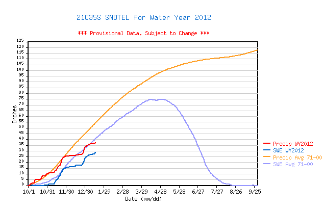
So that makes up most of what appeared to be 7-8" below the average. Coincidentally, the Paradise SWE on January 23, 2011, was 38.2", within 0.1" of today's value.
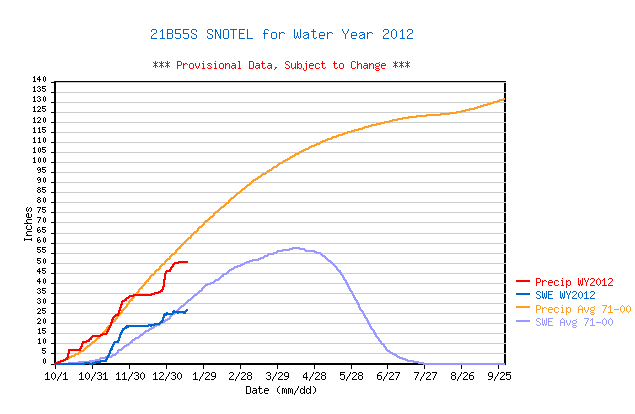
I checked several other SNOTEL site graphs, and all appear to have not been updated since mid-January. For example Olallie Meadows:
Another point: nearly half of the current depth is NOT unconsolidated fluff. There was rain (to about 7000 ft in WA, and 9000 ft in OR) twice during this 9-day storm cycle, so the several feet of recent snowfall is actually fairly well consolidated, except for the uppermost 1-2 ft of it. And the bottom half of the snowpack (what was there as of January 14) is much more consolidated and dense than an average January 23 snowpack. The overall snowpack densities at most of those SNOTEL sites appear to be roughly 30-35% (based on a quick check with mental calculations), which is denser than normal for late January.
The Summary of Western US SNOTEL Snow/Precipitation Update Report for January 23 shows that overall throughout WA, the SWE is at 97% of average, despite precip still being only 87% of average.
Replied by Amar Andalkar on topic Re: Snowpack in WA now ABOVE normal & DEEPER than 2011
Although actual snowpack depth is above normal almost everywhere at the moment, I think snow-water equivalent is still below normal in many places. Paradise, for example is still 7-8" below the 40yr average for SWEq.
I guess what I'm trying to say is that nearly half of the current depth is unconsolidated fluff. In a week or two, we'll see how deep it still is.
The SNOTEL graphs (which show SWE and precip compared to averages) are not updating daily, they appear to be over a week behind (I think they all go through January 15 as of now). All of the recent snowfall from January 15 to now is missing. Here is Paradise SNOTEL, which is reporting 38.1" of SWE as of January 23, but the graph shows only about 30" and is entirely missing the past week's large increase:
So that makes up most of what appeared to be 7-8" below the average. Coincidentally, the Paradise SWE on January 23, 2011, was 38.2", within 0.1" of today's value.
I checked several other SNOTEL site graphs, and all appear to have not been updated since mid-January. For example Olallie Meadows:
Another point: nearly half of the current depth is NOT unconsolidated fluff. There was rain (to about 7000 ft in WA, and 9000 ft in OR) twice during this 9-day storm cycle, so the several feet of recent snowfall is actually fairly well consolidated, except for the uppermost 1-2 ft of it. And the bottom half of the snowpack (what was there as of January 14) is much more consolidated and dense than an average January 23 snowpack. The overall snowpack densities at most of those SNOTEL sites appear to be roughly 30-35% (based on a quick check with mental calculations), which is denser than normal for late January.
The Summary of Western US SNOTEL Snow/Precipitation Update Report for January 23 shows that overall throughout WA, the SWE is at 97% of average, despite precip still being only 87% of average.
Please Log in or Create an account to join the conversation.
- RonL
-
- User
-
Less
More
- Posts: 259
- Thank you received: 0
14 years 4 months ago #203576
by RonL
Replied by RonL on topic Re: Snowpack in WA now ABOVE normal & DEEPER than 2011
Guilty as charged. A lot of runs just don't ski right without a hundred inches or so. I am spoiled. You should hear our friends in other states bag on me when I complain about the snowpack here. They have no sense of humor.
Please Log in or Create an account to join the conversation.
- hyak.net
-
- User
-
Less
More
- Posts: 601
- Thank you received: 0
14 years 4 months ago #203606
by hyak.net
Replied by hyak.net on topic Re: Snowpack in WA now ABOVE normal & DEEPER than 2011
Tonight is the first real rain we have had since the storm cycle started on Snoqualmie Pass. We had a brief 1 1/2 hrs of mist/drizzle but it didn't even amount to enough to make crust on the snow (and temps were in the mid 20's). It is raining good now so whatever snow we have should start packing down now. (currently 32 degrees and raining )
As far as Snoq Pass snow totals this season, Nov was average, Dec was about 25% of normal and this month is on par to be average as long as the snow keeps coming. My snow totals are very consistent with the ski area. The DOT is almost always registering more then actual over the past 3 yrs.
FWIW....
Please Log in or Create an account to join the conversation.
- christoph benells
-
- User
-
Less
More
- Posts: 49
- Thank you received: 0
14 years 4 months ago #203617
by christoph benells
Replied by christoph benells on topic Re: Snowpack in WA now ABOVE normal & DEEPER than 2011
amar you are a great asset to pnw backcountry skiers. thank you.
Please Log in or Create an account to join the conversation.
- nhluhr
-
- User
-
Less
More
- Posts: 6
- Thank you received: 0
14 years 4 months ago #203668
by nhluhr
I wonder if the new security measure has made it more difficult to update the graphs? The data is clearly coming in.
Either way, they updated again a couple days ago but appear to be stuck again on roughly the 25th.
Replied by nhluhr on topic Re: Snowpack in WA now ABOVE normal & DEEPER than 2011
I was noticing that too... but if you clicked on their "Last 7 Days" hourly data table, it was all there. Why would the data be there but not updating through to the graph? Perhaps that was related to the security concern they had (you may recall several weeks ago the graphs were removed and a message saying something about security concerns was in its place).The SNOTEL graphs (which show SWE and precip compared to averages) are not updating daily, they appear to be over a week behind (I think they all go through January 15 as of now). All of the recent snowfall from January 15 to now is missing. Here is Paradise SNOTEL, which is reporting 38.1" of SWE as of January 23, but the graph shows only about 30" and is entirely missing the past week's large increase:
I wonder if the new security measure has made it more difficult to update the graphs? The data is clearly coming in.
Either way, they updated again a couple days ago but appear to be stuck again on roughly the 25th.
Please Log in or Create an account to join the conversation.