- Posts: 601
- Thank you received: 0
A very cool find!
- hyak.net
-
 Topic Author
- User
-

Less
More
19 years 11 months ago #175823
by hyak.net
A very cool find! was created by hyak.net
I recently scored a WA ski guide from 1936 full with maps of ski trails from the more popular ski areas in the state. Only one area was shown on the maps to have had a ski lift and that was Baker (the ski escalator as rope tows didn't hit the other areas until '37) The Snoqualmie map shows ski trails all the way from Martin to past Red Mtn, Chair Peak, Silver Peak, etc... Pretty cool (if your into the old ski stuff like I am). It also shows Lodge Lk, Beaver Lk, etc.... anyway, if interested I can scan and upload for viewing.
Please Log in or Create an account to join the conversation.
- Lowell_Skoog
-

- User
-
Less
More
- Posts: 1460
- Thank you received: 16
19 years 11 months ago - 19 years 9 months ago #175824
by Lowell_Skoog
Replied by Lowell_Skoog on topic Re: A very cool find!
That does sound cool, Jack!
I'm curious, is it the Eddie Bauer Winter Sports Guide? The Washington State Historical Museum has a copy of the 1936-37 guide in their research center, but they don't allow people to photocopy it. I have notes about that guide here . I'd certainly be interested to see what you have.
It's not nearly so cool, but the following item prompted some nostalgia when I found it in my old scrapbook recently. I think it was designed as a flag that would go on your car's antenna. I presume it was created around the time that Crystal Mountain opened in the early 1960s. My dad was a founding stockholder (as were many others) and I've had this thing squirreled away for over forty years. It's nice to imagine a string of cars heading up the original Crystal Mountain road with these things flapping away, but I doubt many people actually did that. (The pennant is made of felt.)
www.alpenglow.org/misc/2006/cm-pennant.jpg
(I posted a link instead of an "image" so you can use the thread quota, if you wish.)
Please Log in or Create an account to join the conversation.
- hyak.net
-
Topic Author
- User
-
Less
More
- Posts: 601
- Thank you received: 0
19 years 11 months ago - 19 years 11 months ago #175825
by hyak.net
Replied by hyak.net on topic Re: A very cool find!
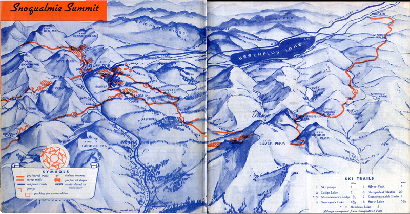
Yes, the Eddie Bauer guide for the 1936/37 season. I mostly wanted it for the ski area maps so I could see where the old ski area slopes were located, trails and such. I've attached a copy of the Snoqulamie map. It is a quick scan (had to do it in 2 parts and paste together), but it gives an idea.
1936 Snoqualmie Map
Cool Crystal pennant.... I have a few Snoqualmie Pass Ski pennants too. I think it was just a 50s-60s kinda thing that kids hung on their walls. Its amazing the kind of strange ski items that were sold at the Summit Inn... One of the weirdest was a pen with a floatie ski jumper that goes across, sorta suppose to look like he's jumping and says "Snoqualmie Pass".
Please Log in or Create an account to join the conversation.
- Lowell_Skoog
-
- User
-
Less
More
- Posts: 1460
- Thank you received: 16
19 years 11 months ago - 19 years 11 months ago #175826
by Lowell_Skoog
Replied by Lowell_Skoog on topic Re: A very cool find!
Thanks Jack. That's quite a treasure you've got there! The Washington State Historical Society guards their copy like the crown jewels.
I love looking at maps like that. The 1936-37 Eddie Bauer guide seems to have been created by skiers who really knew the local ski country. There are many subtle but important details shown.
Notice the tour to Melakwa Lake. It starts at the Mountaineers Lodge at Lodge Lake, from which you have to go DOWN to the highway, across the Snoqualmie River, then ski up Denny Creek to the lake. Although it's not depicted fully, I'm sure that the line from Melakwa Lake is supposed to connect to the line at Snow Lake. That's the Chair Peak loop, which was regarded as one of the finest tours in the area in those days.
It's interesting how Commonweath Basin is depicted as almost a larger ski area than Snoqualmie summit itself. For reference, the summit ski area was established during the 1933-34 season as a Seattle city park. So it was still very small in 1936-37, with no rope tows yet, as you know.
The most prominent feature on the whole map is the Snoqualmie-to-Stampede Pass route, where the Mountaineers ran their annual Patrol Race . That's the long trail that spans the entire map. It's also fascinating to see slopes near Lodge Lake (site of the original Mountaineers Lodge) depicted as "preferred slopes." I don't know how much the trees have grown in 70 years but I can testify that there isn't much skiing there today.
Notice how the tour to Commonwealth Basin is shown extending to (and possibly over) the saddle between Red Mountain and Mt Snoqualmie. In the 1930s, skiers occasionally followed this route from Snoqualmie Pass to the cabin at Goldmyer Hot Springs on the Middle Fork Snoqualmie River. In the 1934 American Ski Annual , Veida Morrow described skiing to the cabin this way:
"Then for four miles downhill running, carefree and as happy as the winds that flew with us. Gone and far behind--the noise and clamor of the city. Not even the beasts of the forests trespassed upon this ground we were skimming. Forgotton all the petty sordid things that ever surround one in this greedy rush to exist among the smokestacks of the city, for here, in the covert of the towering, unchanging mountains, for a few brief days, we lived."
Please Log in or Create an account to join the conversation.
- alpentalcorey
-
- User
-
Less
More
- Posts: 180
- Thank you received: 0
19 years 11 months ago #175842
by alpentalcorey
Goldmeyer is a really nice hotspring. For those that haven't been there it is set in a cave and is quite warm. I'd really like to ski this route sometime, although I wonder if it would be continuously skiable the whole way even in winter (if I am not mistaken Goldmeyer is at ~2,000' or less?).
Really nice find Jack, that is quite a score!
Replied by alpentalcorey on topic Re: A very cool find!
Notice how the tour to Commonwealth Basin is shown extending to (and possibly over) the saddle between Red Mountain and Mt Snoqualmie. In the 1930s, skiers occasionally followed this route from Snoqualmie Pass to the cabin at Goldmyer Hot Springs on the Middle Fork Snoqualmie River.
Goldmeyer is a really nice hotspring. For those that haven't been there it is set in a cave and is quite warm. I'd really like to ski this route sometime, although I wonder if it would be continuously skiable the whole way even in winter (if I am not mistaken Goldmeyer is at ~2,000' or less?).
Really nice find Jack, that is quite a score!
Please Log in or Create an account to join the conversation.
- ron j
-
- User
-
Less
More
- Posts: 1091
- Thank you received: 0
19 years 11 months ago #175843
by ron j
Replied by ron j on topic Re: A very cool find!
Yes, a very nice find.
And, Lowell, great background info from you as well.
Thanks to you both.
And, Lowell, great background info from you as well.
Thanks to you both.
Please Log in or Create an account to join the conversation.