May 24, 2008; Sundial Peak - The Needles (Olympic Ntl. Park)
5/15/08
WA Olympics
6194
13
Having not skied in a few weeks, Phil was anxious to get out the first part of Memorial Day Weekend. He was interested in a return trip up Royal Basin in the Olympics, which definitely sparked my interest. He had a couple of things in mind, one of which was Sundial Peak of The Needles Group (name based on Phil's research from the Olympic Guide). Left the trailhead at 8AM, reaching the middle portion of Royal Basin before NOON. Anyway, we had both eyed this couloir on looker's right of the Needles Group during our respective tours last year (Phil's Mt. Deception descent and my descent of Mt. Mystery w/in 1 week of another).
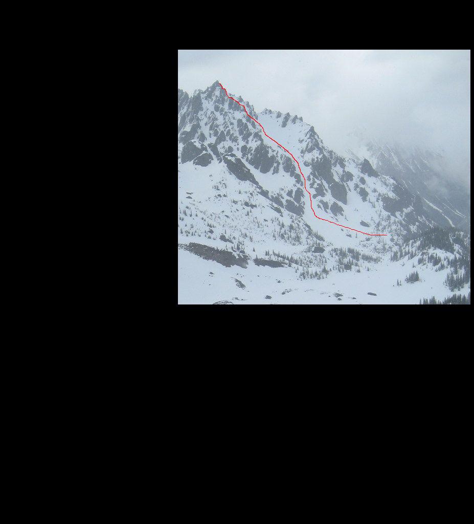
After a quick lunch break, by 12:30 we were booting up the face. The lower flanks were a bit runnelled due to avi debri, but smooth for skiing. Toward the middle of the face, the route doglegs to the left heading to the highest snowpoint below the summit. Conditions for booting were excellent on the upper E/NE Face. Dropped in some time after 2pm and sluff management was our main concern.
After we sidestepped through the upper rock portions, Phil cut the upper face, which was fairly steep, sending a waterfall of snow over the cliffs below (a cool site, wish I had video running). Only a handful of turns could be made at a time on the upper face due to the sluff factor. We sidestepped to the hourglass section on the lower portion of the upper face which required a short straightline through the rocks, connecting us with the lower face.
From here, we opened up turns down the lower half, which upon exiting, a slow cascade of snow ran from the lower face, through the chute to the top of the apron.
So much for the bad weather, we had sun the entire day and perfect views of the San Juans and portions of the Olympics to the south & east. We both left our cameras at home (although Phil did take some with his phone). The attached picture was taken on our trip to the area in April 20, 2007, courtesy Mike Zaretzke, showing the descent.
Approach beta: 10 hrs. roundtrip. Almost 2 hrs. (~4+ miles) on foot before there was continuous snow to skin.
So much for the crop job, that's why I'm in real estate......
Way to make me jealous.
Another photo:

Another photo:
According to the Olympic guide, this peak is called Sundial. The summit was short scramble to the south from the ridge-top, but I didn't feel like doing class 3 in my ski boots.
Martin Pk looked like it had a nice line off the summit, but the bottom was melted out. A direct line right off the top of Deception looked like it might just barely go with some traversing, but would have been a bad idea given the sluffing snow.
Pic of Dave navigating the rocks just below the summit ridge:

Other than a family a short distance from the trailhead, we only saw one other person all day. A guy walking around in the upper basin with what looked like a large outdoor TV antenna.
Martin Pk looked like it had a nice line off the summit, but the bottom was melted out. A direct line right off the top of Deception looked like it might just barely go with some traversing, but would have been a bad idea given the sluffing snow.
Pic of Dave navigating the rocks just below the summit ridge:
Other than a family a short distance from the trailhead, we only saw one other person all day. A guy walking around in the upper basin with what looked like a large outdoor TV antenna.
author=philfort link=topic=10153.msg40802#msg40802 date=1211746004]
Other than a family a short distance from the trailhead, we only saw one other person all day. A guy walking around in the upper basin with what looked like a large outdoor TV antenna.
Maybe for tracking radio-collared wildlife?
That does look like a nice ski line. But you guys don't mention how long the hike on bare trail was to get to it . . .
I'd guess the snow started about 2/3 of the way into the basin, but I don't recall for sure. I'd say we were on bare trail for at least two hours.
I've modified the original TR to include approach info, etc.
Would have been fun to have a little Black Velvet & your humor on the trip ;D
Would have been fun to have a little Black Velvet & your humor on the trip ;D
Sounds like a great trip and impressive line! Nice work!
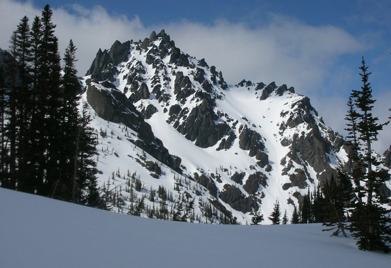
Here is a picture of Sundial from Upper Royal Basin taken Memorial Day:

Great looking line. We could not see your tracks from the basin but it is good that you got it when you did because it rained consistently Sunday night through Monday morning. That line was on our short list of tours while deciding where to ski Monday but the rain limited our options.
Great looking line. We could not see your tracks from the basin but it is good that you got it when you did because it rained consistently Sunday night through Monday morning. That line was on our short list of tours while deciding where to ski Monday but the rain limited our options.
I don't think one could have seen our tracks immediately after skiing it (with the exception of the very top) because the sluffs did a good job erasing them all.
Nice line guys, looks like a lot of fun!
Yeah Ryan - it was your cup of tea, too. A little spicey w/ a couple of shenanigans up top that would likely keep most away - esp. considering the snow conditions.
author=philfort link=topic=10153.msg40802#msg40802 date=1211746004]
we only saw one other person all day. A guy walking around in the upper basin with what looked like a large outdoor TV antenna.
We ran into a guy doing the same up near eagle point when I asked him what he was doing he said he was tracking the Marmots. According to him the Olympics have the biggest marmots in the world.
author=David_Coleman link=topic=10153.msg40799#msg40799 date=1211742591]
So much for the bad weather, we had sun the entire day
So much for the wet and rowdy weekend!
:)
Nice TR. It sounds like a great ski!
We definitely had some "wet", but we couldn't quite rope in the rowdy factor; rather, the stoke factor!
Reply to this TR
Please login first: