Jan 1, 2011, Mt Rainier, Muir: Warm, Sunny and Calm
1/1/11
WA Cascades West Slopes South (Mt Rainier)
8318
4
The Rainier forecast looked too good to pass up: sunny, not as cold as the last few days, and very light winds. My last-minute, early AM decision to drive down there and head up to Camp Muir, turned out to be exceptional. It felt like a once-in-a-lifetime experience: skinning up to Camp Muir on NEW YEARS DAY in warm sunshine, with temps in the mid-20s, and almost no wind at all.

The weather was SO NICE, the snow conditions almost didn't matter -- but they were fairly good, certainly much better than typical winter above-treeline nastiness. Wind-packed powder, mostly smooth with minimal sastrugi, no sun crust yet. A bit of breakable wind crust in some areas and small pockets, which provided the worst (most-challenging) turns of the day, while much larger sections had smooth medium-density powder which offered the best turns. Sure, I had skied much lighter and nicer powder above Source Lake near Alpental on New Years Eve yesterday, but that's fine -- today was about enjoying the sunshine and scenery, as high up as you can get right now in the Northwest in an easy day.
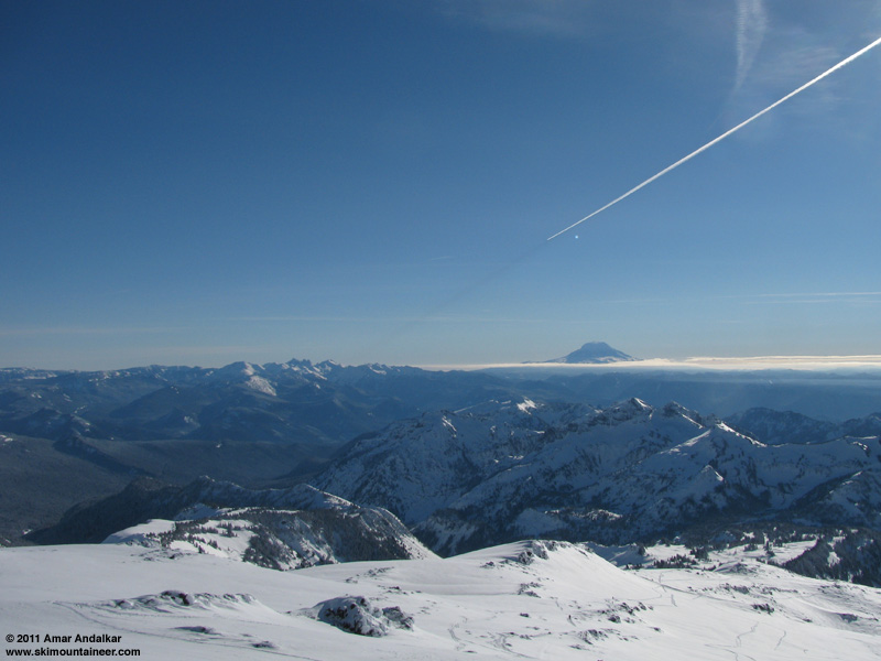
Jet contrail and its visible shadow, with Mount Adams and Goat Rocks (left) in the distance.
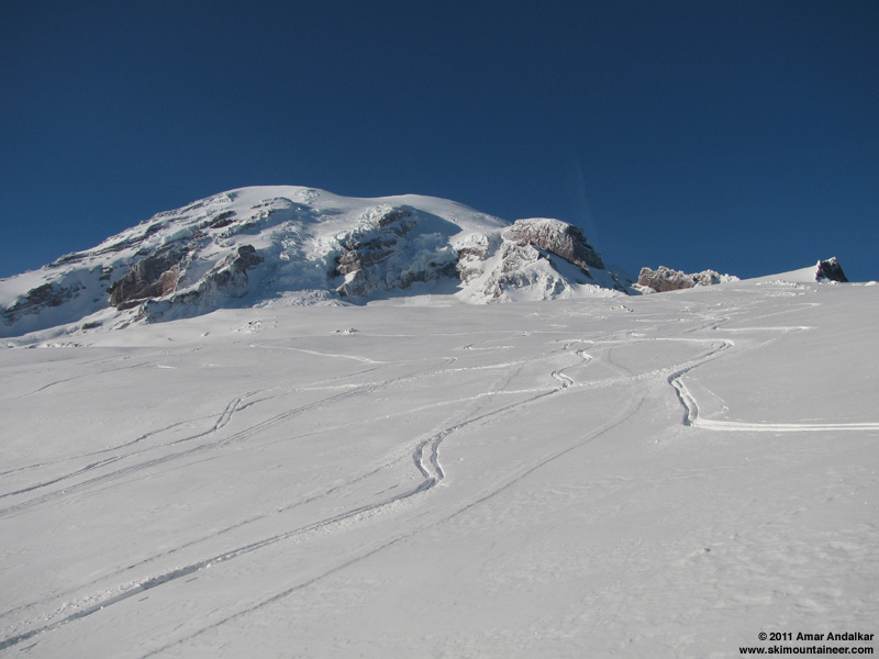
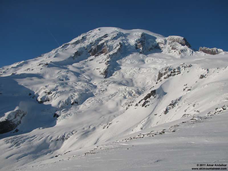
Looking up Cowlitz Cleaver towards the summit dome from Camp Muir.
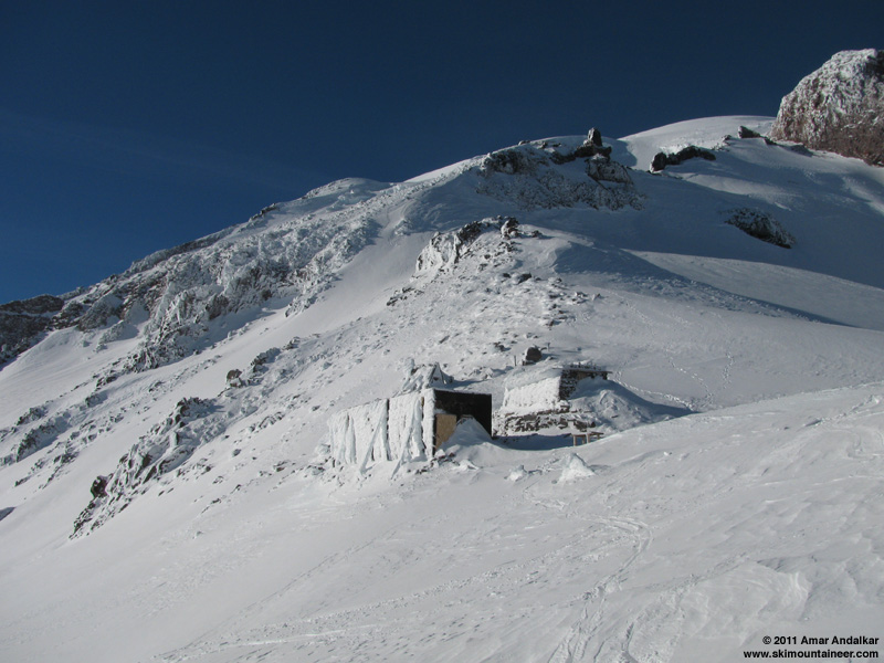
I reached Camp Muir just after 2pm, and took a long break basking in the sunshine and stillness. The buildings at Muir are heavily rimed (including the solidly-frozen NWAC wind gauges), but the Public Shelter is in great shape with easy access via the entire door (not just the upper half) and almost no snow inside. The Snowfield was fairly deserted, only a handful of skiers up there today (a few still skinning up at 3pm), plus another handful of snowshoers. The emptiness up high was in sharp contrast to the absolute mob scene at Paradise when I skied back down to the car around 3:30pm, with sleds and tubes and kids everywhere.
A pair of climbers had attempted to summit via Gib Ledges in the early morning, but they turned around below 12K (before starting across the Ledges) due to avy concerns. I saw three large avalanches fall from Nisqually Icefall and Ice Cliff between noon and 2pm, a clear product of sunshine and warming.
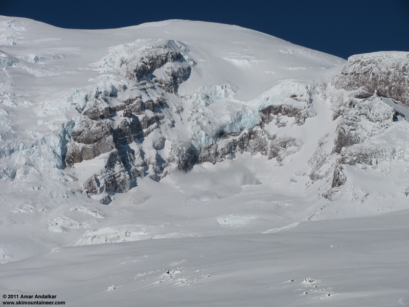
Avalanche from Nisqually Ice Cliff just after noon.
However, snow stability appeared to be excellent along the entire route from Paradise to Muir though, with no signs of anything sliding (or even looking risky) on Pan Face and the steep rolls above Pan Point. No one had yet dared to ski Nisqually Chute, there were no tracks visible in there.
A great start to 2011! Happy New Year!!
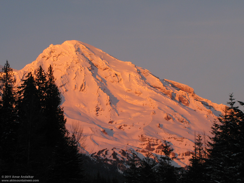
Sunset glow on Point Success and Kautz Glacier.
By the way, the road to Paradise opened at 8am (although I got there about 90 minutes later), and the drive up was no problem, luckily I didn't get stuck behind any slowpokes. The entire 18 miles of park road was compact snow, but not icy and with good traction. Chains were required on all vehicles, except AWD/4WD, and rangers were checking at Longmire if those with AWD/4WD had chains in the vehicle.
[tt]MOUNT RAINIER RECREATIONAL FORECAST
NATIONAL WEATHER SERVICE SEATTLE WA
400 AM PST SAT JAN 1 2011
SYNOPSIS...A STRONG UPPER LEVEL RIDGE OVER THE REGION COUPLED WITH OFFSHORE LOW LEVEL FLOW WILL KEEP WESTERN WASHINGTON MOSTLY CLEAR AND DRY INTO EARLY NEXT WEEK...WITH CONTINUED COLD WEATHER THROUGH MONDAY. THE UPPER RIDGE WILL GRADUALLY BREAK DOWN...WITH A WEAK WEATHER SYSTEM POSSIBLY REACHING WESTERN WASHINGTON AROUND WEDNESDAY.
SATURDAY...SUNNY. FREEZING LEVEL 2000 FEET.
SATURDAY NIGHT...PARTLY CLOUDY. FREEZING LEVEL 3500 FEET.
SUNDAY...MOSTLY SUNNY. FREEZING LEVEL 2500 FEET.
SUNDAY NIGHT...PARTLY CLOUDY. FREEZING LEVEL 1500 FEET.
MONDAY...MOSTLY SUNNY. FREEZING LEVEL 500 FEET.
MONDAY NIGHT...PARTLY CLOUDY. FREEZING LEVEL 1000 FEET.
TUESDAY AND TUESDAY NIGHT...MOSTLY CLOUDY. FREEZING LEVEL 1500 FEET.
WEDNESDAY...MOSTLY CLOUDY WITH A CHANCE OF SNOW AND RAIN. SNOW LEVEL 500 FEET.
WEDNESDAY NIGHT AND THURSDAY...SNOW AND RAIN LIKELY. SNOW LEVEL 3000 FEET.
THURSDAY NIGHT...SHOWERS LIKELY. SNOW LEVEL 3000 FEET.
FRIDAY...SNOW SHOWERS LIKELY.
TEMPERATURE AND WIND FORECASTS FOR SELECTED LOCATIONS.
SAT SAT SUN SUN MON
NIGHT NIGHT
SUMMIT (14411 FT) 3 2 5 6 6
NW 7 NW 16 NE 18 N 19 NW 23
CAMP MUIR(10188 FT) 18 17 20 23 21
NW 8 NW 13 N 7 N 11 NW 17
PARADISE (5420 FT) 25 24 27 14 32
E 4 N 1 NE 4 NE 6 NE 2
LONGMIRE (2700 FT) 29 22 31 21 34
E 6 NE 3 NE 4 NE 7 NE 3
[/tt]
[tt]
Northwest Weather and Avalanche Center Northwest Weather and Avalanche Center
Paradise, Mt Rainier National Park, Washington Camp Muir, Mt Rainier National Park, Washington
Data also courtesy Mt Rainier National Park
Wind sensors unheated and may rime
MM/DD Hour Temp RH Wind Wind Wind Hour Total 24 Hr Total Solar MM/DD Hour Temp RH Wind Wind Wind Wind Solar
PST F % Avg Max Dir Prec. Prec. Snow Snow W/m2 PST F % Min Avg Max Dir W/m2
5550' 5550' 5500' 5500' 5500' 5550' 5550' 5550' 5550' 5500' 10100' 10100' 10100' 10100' 10100' 10100' 10100'
----------------------------------------------------------------------- -------------------------------------------------------------
1 1 0 15 93 5 9 67 0 0 1 98 0 1 1 0 12 93 0 0 0 253 0
1 1 100 18 93 5 9 61 0 0 1 98 0 1 1 100 12 93 0 0 0 253 0
1 1 200 21 94 3 6 39 0 0 1 98 0 1 1 200 10 92 0 0 0 253 0
1 1 300 20 94 4 6 59 0 0 1 98 0 1 1 300 11 92 0 0 0 253 0
1 1 400 20 94 4 8 51 0 0 1 98 0 1 1 400 11 92 0 0 0 253 0
1 1 500 20 94 3 6 40 0 0 1 97 0 1 1 500 10 92 0 0 0 253 0
1 1 600 21 94 3 5 37 0 0 1 98 0 1 1 600 11 92 0 0 0 253 0
1 1 700 22 94 4 6 41 0 0 0 97 0 1 1 700 11 92 0 0 0 253 0
1 1 800 21 94 4 5 45 0 0 1 98 2 1 1 800 11 92 0 0 0 253 6
1 1 900 24 94 2 4 6 0 0 0 97 59 1 1 900 13 92 0 0 0 253 63
1 1 1000 26 94 0 1 13 0 0 0 97 195 1 1 1000 17 92 0 0 0 253 197
1 1 1100 27 94 1 3 284 0 0 0 97 318 1 1 1100 20 92 0 0 0 256 254
1 1 1200 29 95 1 4 257 0 0 0 97 383 1 1 1200 26 91 0 0 0 283 284
1 1 1300 32 100 1 3 260 0 0 0 96 392 1 1 1300 26 93 0 0 0 246 285
1 1 1400 37 96 0 0 239 0 0 0 96 346 1 1 1400 25 93 0 0 0 235 266
1 1 1500 37 96 0 1 275 0 0 -0 95 259 1 1 1500 23 94 0 0 0 235 344
1 1 1600 31 100 0 2 275 0 0 0 95 129 1 1 1600 19 94 0 0 0 243 141
1 1 1700 26 100 0 0 41 0 0 0 96 19 1 1 1700 15 94 0 0 0 234 31
1 1 1800 25 100 0 0 7 0 0 0 96 0 1 1 1800 13 93 0 0 0 226 1
1 1 1900 25 100 0 0 64 0 0 1 96 0 1 1 1900 13 93 0 0 0 226 0
1 1 2000 25 100 0 0 345 0 0 0 96 0 1 1 2000 12 93 0 0 0 226 0
1 1 2100 26 100 0 0 325 0 0 1 96 0 1 1 2100 13 92 0 0 0 226 0
1 1 2200 26 100 0 0 307 0 0 0 95 0 1 1 2200 12 93 0 0 0 226 0
1 1 2300 27 100 0 2 304 0 0 0 95 0 1 1 2300 12 92 0 0 0 226 0
[/tt]
(Edited Jan2 to add NWAC telemetry.)
The weather was SO NICE, the snow conditions almost didn't matter -- but they were fairly good, certainly much better than typical winter above-treeline nastiness. Wind-packed powder, mostly smooth with minimal sastrugi, no sun crust yet. A bit of breakable wind crust in some areas and small pockets, which provided the worst (most-challenging) turns of the day, while much larger sections had smooth medium-density powder which offered the best turns. Sure, I had skied much lighter and nicer powder above Source Lake near Alpental on New Years Eve yesterday, but that's fine -- today was about enjoying the sunshine and scenery, as high up as you can get right now in the Northwest in an easy day.
Jet contrail and its visible shadow, with Mount Adams and Goat Rocks (left) in the distance.
Looking up Cowlitz Cleaver towards the summit dome from Camp Muir.
I reached Camp Muir just after 2pm, and took a long break basking in the sunshine and stillness. The buildings at Muir are heavily rimed (including the solidly-frozen NWAC wind gauges), but the Public Shelter is in great shape with easy access via the entire door (not just the upper half) and almost no snow inside. The Snowfield was fairly deserted, only a handful of skiers up there today (a few still skinning up at 3pm), plus another handful of snowshoers. The emptiness up high was in sharp contrast to the absolute mob scene at Paradise when I skied back down to the car around 3:30pm, with sleds and tubes and kids everywhere.
A pair of climbers had attempted to summit via Gib Ledges in the early morning, but they turned around below 12K (before starting across the Ledges) due to avy concerns. I saw three large avalanches fall from Nisqually Icefall and Ice Cliff between noon and 2pm, a clear product of sunshine and warming.
Avalanche from Nisqually Ice Cliff just after noon.
However, snow stability appeared to be excellent along the entire route from Paradise to Muir though, with no signs of anything sliding (or even looking risky) on Pan Face and the steep rolls above Pan Point. No one had yet dared to ski Nisqually Chute, there were no tracks visible in there.
A great start to 2011! Happy New Year!!
Sunset glow on Point Success and Kautz Glacier.
By the way, the road to Paradise opened at 8am (although I got there about 90 minutes later), and the drive up was no problem, luckily I didn't get stuck behind any slowpokes. The entire 18 miles of park road was compact snow, but not icy and with good traction. Chains were required on all vehicles, except AWD/4WD, and rangers were checking at Longmire if those with AWD/4WD had chains in the vehicle.
[tt]MOUNT RAINIER RECREATIONAL FORECAST
NATIONAL WEATHER SERVICE SEATTLE WA
400 AM PST SAT JAN 1 2011
SYNOPSIS...A STRONG UPPER LEVEL RIDGE OVER THE REGION COUPLED WITH OFFSHORE LOW LEVEL FLOW WILL KEEP WESTERN WASHINGTON MOSTLY CLEAR AND DRY INTO EARLY NEXT WEEK...WITH CONTINUED COLD WEATHER THROUGH MONDAY. THE UPPER RIDGE WILL GRADUALLY BREAK DOWN...WITH A WEAK WEATHER SYSTEM POSSIBLY REACHING WESTERN WASHINGTON AROUND WEDNESDAY.
SATURDAY...SUNNY. FREEZING LEVEL 2000 FEET.
SATURDAY NIGHT...PARTLY CLOUDY. FREEZING LEVEL 3500 FEET.
SUNDAY...MOSTLY SUNNY. FREEZING LEVEL 2500 FEET.
SUNDAY NIGHT...PARTLY CLOUDY. FREEZING LEVEL 1500 FEET.
MONDAY...MOSTLY SUNNY. FREEZING LEVEL 500 FEET.
MONDAY NIGHT...PARTLY CLOUDY. FREEZING LEVEL 1000 FEET.
TUESDAY AND TUESDAY NIGHT...MOSTLY CLOUDY. FREEZING LEVEL 1500 FEET.
WEDNESDAY...MOSTLY CLOUDY WITH A CHANCE OF SNOW AND RAIN. SNOW LEVEL 500 FEET.
WEDNESDAY NIGHT AND THURSDAY...SNOW AND RAIN LIKELY. SNOW LEVEL 3000 FEET.
THURSDAY NIGHT...SHOWERS LIKELY. SNOW LEVEL 3000 FEET.
FRIDAY...SNOW SHOWERS LIKELY.
TEMPERATURE AND WIND FORECASTS FOR SELECTED LOCATIONS.
SAT SAT SUN SUN MON
NIGHT NIGHT
SUMMIT (14411 FT) 3 2 5 6 6
NW 7 NW 16 NE 18 N 19 NW 23
CAMP MUIR(10188 FT) 18 17 20 23 21
NW 8 NW 13 N 7 N 11 NW 17
PARADISE (5420 FT) 25 24 27 14 32
E 4 N 1 NE 4 NE 6 NE 2
LONGMIRE (2700 FT) 29 22 31 21 34
E 6 NE 3 NE 4 NE 7 NE 3
[/tt]
[tt]
Northwest Weather and Avalanche Center Northwest Weather and Avalanche Center
Paradise, Mt Rainier National Park, Washington Camp Muir, Mt Rainier National Park, Washington
Data also courtesy Mt Rainier National Park
Wind sensors unheated and may rime
MM/DD Hour Temp RH Wind Wind Wind Hour Total 24 Hr Total Solar MM/DD Hour Temp RH Wind Wind Wind Wind Solar
PST F % Avg Max Dir Prec. Prec. Snow Snow W/m2 PST F % Min Avg Max Dir W/m2
5550' 5550' 5500' 5500' 5500' 5550' 5550' 5550' 5550' 5500' 10100' 10100' 10100' 10100' 10100' 10100' 10100'
----------------------------------------------------------------------- -------------------------------------------------------------
1 1 0 15 93 5 9 67 0 0 1 98 0 1 1 0 12 93 0 0 0 253 0
1 1 100 18 93 5 9 61 0 0 1 98 0 1 1 100 12 93 0 0 0 253 0
1 1 200 21 94 3 6 39 0 0 1 98 0 1 1 200 10 92 0 0 0 253 0
1 1 300 20 94 4 6 59 0 0 1 98 0 1 1 300 11 92 0 0 0 253 0
1 1 400 20 94 4 8 51 0 0 1 98 0 1 1 400 11 92 0 0 0 253 0
1 1 500 20 94 3 6 40 0 0 1 97 0 1 1 500 10 92 0 0 0 253 0
1 1 600 21 94 3 5 37 0 0 1 98 0 1 1 600 11 92 0 0 0 253 0
1 1 700 22 94 4 6 41 0 0 0 97 0 1 1 700 11 92 0 0 0 253 0
1 1 800 21 94 4 5 45 0 0 1 98 2 1 1 800 11 92 0 0 0 253 6
1 1 900 24 94 2 4 6 0 0 0 97 59 1 1 900 13 92 0 0 0 253 63
1 1 1000 26 94 0 1 13 0 0 0 97 195 1 1 1000 17 92 0 0 0 253 197
1 1 1100 27 94 1 3 284 0 0 0 97 318 1 1 1100 20 92 0 0 0 256 254
1 1 1200 29 95 1 4 257 0 0 0 97 383 1 1 1200 26 91 0 0 0 283 284
1 1 1300 32 100 1 3 260 0 0 0 96 392 1 1 1300 26 93 0 0 0 246 285
1 1 1400 37 96 0 0 239 0 0 0 96 346 1 1 1400 25 93 0 0 0 235 266
1 1 1500 37 96 0 1 275 0 0 -0 95 259 1 1 1500 23 94 0 0 0 235 344
1 1 1600 31 100 0 2 275 0 0 0 95 129 1 1 1600 19 94 0 0 0 243 141
1 1 1700 26 100 0 0 41 0 0 0 96 19 1 1 1700 15 94 0 0 0 234 31
1 1 1800 25 100 0 0 7 0 0 0 96 0 1 1 1800 13 93 0 0 0 226 1
1 1 1900 25 100 0 0 64 0 0 1 96 0 1 1 1900 13 93 0 0 0 226 0
1 1 2000 25 100 0 0 345 0 0 0 96 0 1 1 2000 12 93 0 0 0 226 0
1 1 2100 26 100 0 0 325 0 0 1 96 0 1 1 2100 13 92 0 0 0 226 0
1 1 2200 26 100 0 0 307 0 0 0 95 0 1 1 2200 12 93 0 0 0 226 0
1 1 2300 27 100 0 2 304 0 0 0 95 0 1 1 2300 12 92 0 0 0 226 0
[/tt]
(Edited Jan2 to add NWAC telemetry.)
Living vicariously. Thanks, Amar. Happy New Year, you all!
Absolutely beautiful. Great way to start off 2011.
Mid 20's? Good call, Amar!
We were jogging across Snow Lake at about the same time, about 5 degrees in the shade with a 40mph tailwind . . .
We were jogging across Snow Lake at about the same time, about 5 degrees in the shade with a 40mph tailwind . . .
-3 at the Smith Brook TH at 9AM. It felt colder at the shaded end of Lichtenwasser Lake around noon. What a contrast.
Reply to this TR
Please login first: