Dec 19, 2009, Rogers Pass, BC
12/19/09
Canada BC
4630
7
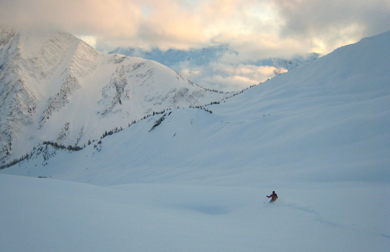
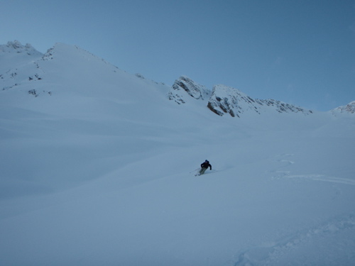
Skierlyles and I skinned up towards Balu Pass and then skied below below Video Peak near Ursus tress. It was Canadian bluebird, which means the sun was out for about an hour before setting at 3:30. It actually rained a bit the night before so there was a thin rain crust but not enough to screw with the powder bliss. Stunning scenery.
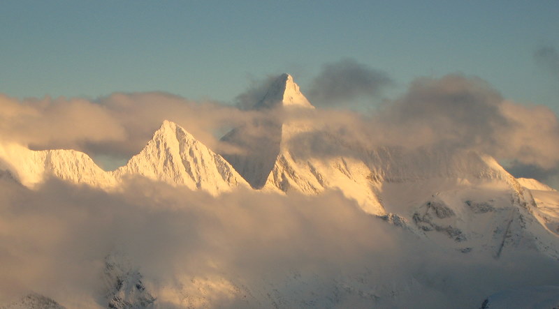
Awesome 2nd photo, sometimes the scenery is worth it even when the skiing isn't. It's always nice when the two coincide though:)
Thanks for the great Pics....
Nice shots! I was there about 5 years ago and loved it. Everyone (well only those hardy enough to make the drive) should ski up there.
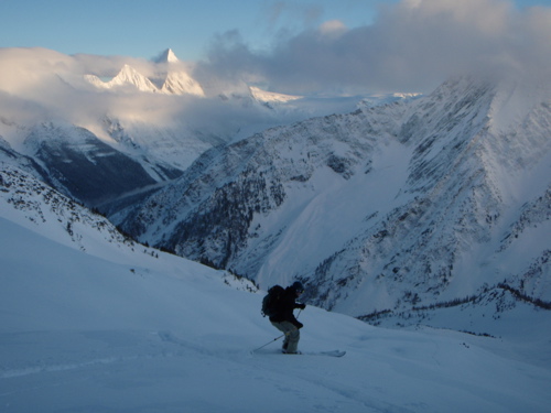
Beautiful! Looks like Chris is having an okay time in the first pic ;)
Had an amazing time out at Roger's Pass and enjoyed skiing the new Revelstoke ski area as well. Ski area is still in it's infancy but has alot of potential to be a great area. Soon enough they will get those kinks ironed out, and the skiing will only get better as they open up more terrain and add more lifts. Cycling the goods usually took two chair rides and lots of groomer bombing before riding back up (legs trashed of course).
Backcountry was epic- I highly recommend getting out there if you never have, and although it is quite a drive, it is well worth it (esp. when is is raining in Washington).
The snowpack was a new experience for me as I have done most of my backcountry skiing in Washington and have not yet experienced the subtleties of a more "Continental like" snowpack. Facets provided some sketch factor as they lie 40 to 50 cm deep and are below a somewhat heavy, upside down snowpack structure. New wet snow (5 to 10 cm) and temps near 0 C on Sunday was cause for some concern, so we stuck to the trees and lowered our exposure from above. Several locals mentioned the snowpack seeming pretty stable Saturday (below the alpine), and that the windloading was the real concern near the passes and on N to NE facing slopes. Thin, easily breakable rain crust evident on south aspects and open windswept terrain features about 10-20 cm down but not noticeable on N to NE facing slopes (due to wind loading). This layer is no doubt covered up by now with their recent precip.
In the Resort- trees at lower elevations (below 1,500 m) and on South facing slopes had noticeable chicken-heads poking out (from tree bombs) and a firmer crust (rain event a week or so ago). This was not noticed in North Bowl treed areas at similar elevations. Experienced a weak slab release when ski cutting a convexity on Monday (inbounds). This entrained the new wet snow surface and did not propagate down to the faceted layer (did not really have a chance to as it was a ~40 deg convexity in trees with a short run-out (slope was only 20 meters long at most before flattening out). Snow quality was still quite good despite being a bit heavy.
All in all a great trip out. The one thing we wished we had done was to build in a half day skiing on the drive out and back. 8 hrs each way is a long way to drive without skiing and there were some great peaks along the way. Next time I would make a short detour out to the Coquahilla area or just right off the highway before heading back home.
Maybe GaryandJan can chime in with more recent/ additional info? Sorry we missed you guys. I am sure you had a blast.
Now bring us more winter here in Washington. All I want for Christmas is some powder!
More pics:
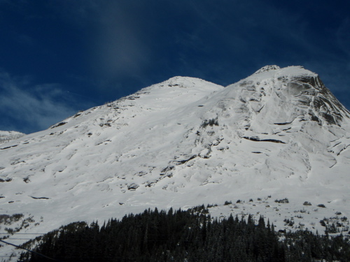
1st- some peak off of 1 on the way home, probably near Hope (anybody know it?)
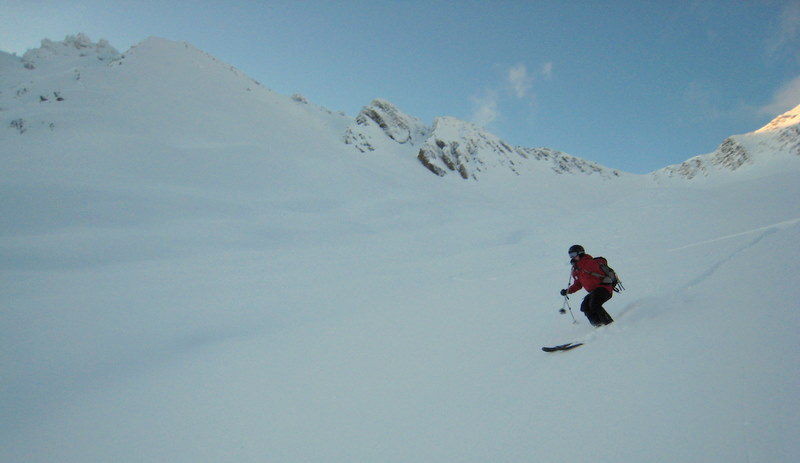
2nd- Jay with Video Peak in the background
3rd- Jay with Cheops
Backcountry was epic- I highly recommend getting out there if you never have, and although it is quite a drive, it is well worth it (esp. when is is raining in Washington).
The snowpack was a new experience for me as I have done most of my backcountry skiing in Washington and have not yet experienced the subtleties of a more "Continental like" snowpack. Facets provided some sketch factor as they lie 40 to 50 cm deep and are below a somewhat heavy, upside down snowpack structure. New wet snow (5 to 10 cm) and temps near 0 C on Sunday was cause for some concern, so we stuck to the trees and lowered our exposure from above. Several locals mentioned the snowpack seeming pretty stable Saturday (below the alpine), and that the windloading was the real concern near the passes and on N to NE facing slopes. Thin, easily breakable rain crust evident on south aspects and open windswept terrain features about 10-20 cm down but not noticeable on N to NE facing slopes (due to wind loading). This layer is no doubt covered up by now with their recent precip.
In the Resort- trees at lower elevations (below 1,500 m) and on South facing slopes had noticeable chicken-heads poking out (from tree bombs) and a firmer crust (rain event a week or so ago). This was not noticed in North Bowl treed areas at similar elevations. Experienced a weak slab release when ski cutting a convexity on Monday (inbounds). This entrained the new wet snow surface and did not propagate down to the faceted layer (did not really have a chance to as it was a ~40 deg convexity in trees with a short run-out (slope was only 20 meters long at most before flattening out). Snow quality was still quite good despite being a bit heavy.
All in all a great trip out. The one thing we wished we had done was to build in a half day skiing on the drive out and back. 8 hrs each way is a long way to drive without skiing and there were some great peaks along the way. Next time I would make a short detour out to the Coquahilla area or just right off the highway before heading back home.
Maybe GaryandJan can chime in with more recent/ additional info? Sorry we missed you guys. I am sure you had a blast.
Now bring us more winter here in Washington. All I want for Christmas is some powder!
More pics:
1st- some peak off of 1 on the way home, probably near Hope (anybody know it?)
2nd- Jay with Video Peak in the background
3rd- Jay with Cheops
Sounds like a fine trip. It's good someone is getting the wild goods of CAN.
Skierlyles, that first photo you posted is of Yak Peak, home to some long rock routes.
Skierlyles, that first photo you posted is of Yak Peak, home to some long rock routes.
author=skierlyles link=topic=14893.msg62523#msg62523 date=1261602170]
More pics:
1st- some peak off of 1 on the way home, probably near Hope (anybody know it?)
The slabby peak is Yak Peak- it looks nice and easy from highway and has suckered many: http://www.matthewbuckle.net/climb/tripreports/yak.php
http://www.bivouac.com/PhotoPg.asp?PhotoId=1995
- keep quiet about Roger's would ya - next thing you'll be telling everyone about the hot tub and skier specials at the best western .... shhh!
Reply to this TR
Please login first: